Dvaravati
Dvaravati | |||||||||||||||||||||||||||||||||||
|---|---|---|---|---|---|---|---|---|---|---|---|---|---|---|---|---|---|---|---|---|---|---|---|---|---|---|---|---|---|---|---|---|---|---|---|
| 6th–11th century | |||||||||||||||||||||||||||||||||||
Dvaravati civilization and contemporary Asian polities, 800 CE | |||||||||||||||||||||||||||||||||||
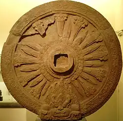
Spread of Dvaravati culture and Mon Dvaravati sites Mon wheel of the law (Dharmacakra), art of Dvaravati period, c. 8th century CE Buddha, art of Dvaravati period, c. 8th–9th century CE Bronze double denarius of the Gallic Roman emperor Victorinus (269–271 AD) found at U Thong, Thailand Khao Khlang Nai was a Buddhist sanctuary. The central stupa, rectangular in shape and oriented toward the east, is characteristic of dvaravati architectural style, dated back around 6th–7th century CE. Khao Khlang Nok, was an ancient Dvaravati-style stupa in Si Thep, dated back around 8th–9th century CE, at present, it is large laterite base. | |||||||||||||||||||||||||||||||||||
| Capital | |||||||||||||||||||||||||||||||||||
| Common languages | Old Mon | ||||||||||||||||||||||||||||||||||
| Religion | |||||||||||||||||||||||||||||||||||
| Historical era | Post-classical era | ||||||||||||||||||||||||||||||||||
• Established | 6th century | ||||||||||||||||||||||||||||||||||
• Disestablished | 11th century | ||||||||||||||||||||||||||||||||||
| |||||||||||||||||||||||||||||||||||





Dvaravati[a] refers to a network of early historic polities in present-day central Thailand, conventionally dated from about the 6th to the 11th century;[5][6]: 234 archaeological evidence, however, places the beginnings of its culture several centuries earlier, in a phase usually called Proto-Dvaravati. It is tentatively regarded as a successor to the polity Chinese sources call Lang-chia or Lang-ya-hsiu.[7]: 268–270, 281 Chinese Buddhist accounts of the mid-7th century place a Buddhist kingdom called To-lo-po-ti west of Isanapura in Cambodia, east of Sri Ksetra in Burma,[8]: 76 [9]: 37 and north of Pan Pan.[7]: 267, 269 To the north it bordered Jiā Luó Shě Fú (迦逻舍佛), identified with Canasapura in the upper Mun-Chi basin[10] and with Si Thep in the Pa Sak basin.[11]: 38–9 Dvaravati is recorded to have sent embassies to the Chinese court in 583,[12] around 605–616,[7]: 264 in 638, 640, 643, 647, and 649.[13]: 132 Baker and Pasuk count three under the name To-lo-po-ti, in 638, 640 and 649.[14]: 16
The term also denotes a wider cultural and artistic sphere associated with a loose conglomeration of Mon principalities rather than a centralized state.[3] Mon communities, possibly including maritime traders, are thought to have contributed to the emergence and spread of Dvaravati culture in the Chao Phraya valley by the early centuries CE,[15]: 32 following a transitional Proto-Dvaravati phase in the 2nd to 5th centuries associated with principalities such as Chin Lin and Tun Sun in the western plains alongside Tou Yuan to the east.[3]
Dvaravati's early political centre is disputed. Proposed centers include Ayojjhapura (Si Thep),[2] Sambuka (Nakhon Pathom),[16]: 10–1 and Avadhyapura (Si Mahosot).[11] Prominence appears to have passed by the mid-7th century to Lavo's Lavapura, after Tou Yuan was absorbed in 647. Some scholars date the shift later, to the 10th or 11th centuries and the decline of Si Thep;[2] others treat Lavapura as a separate polity, later the Lavo Kingdom, lying within the Dvaravati sphere.[16]: 10–1, 43
Its decline probably had several overlapping causes rather than one:[7]: 283 [17]: 41 the expansion of Angkor from the lower Mekong between the 11th and 13th centuries,[18] northward campaigns by Tambralinga under King Sujita in the mid-10th century, reported to have taken Lavo,[7]: 283 [17]: 16 Angkorian instability and warfare in the early 11th century reaching the Menam valley,[19] and Pagan incursions into central Thailand in the 11th and 12th.[17]: 41 [20]: 4 Jean Boisselier held that Dvaravati lost the eastern centres such as Lavo by the 10th or 11th century while the Mon principalities of the western plains lasted into the early 12th, coming briefly under Angkorian influence under Jayavarman VII (r. 1181–1218).[16]: 262–3 Thereafter, the region entered the Xiān period, marked by the emergence of Suphannabhum, Phrip Phri, and Ayodhya, the latter reasserting control over Lavo by the 14th century.
History


Dvaravati culture is marked by moated urban settlements, of which U Thong in present-day Suphan Buri Province is generally taken to be the earliest; other major sites are Nakhon Pathom, Pong Tuek, Si Thep, Khu Bua and Si Mahosot.[3] The name comes from coins inscribed in Sanskrit śrī dvāravatī, "that which has gates".[21]: 301 The Wat Phra Ngam Inscription (N.Th. 21), found in 2019 in Nakhon Pathom province and dated to the 6th century, names three cities, Śrīyānaṁdimiriṅga or Śrīyānaṁdimiriṅgapratipura, Hastināpurī and Dvāravatī, which suggests that Nakhon Pathom was Dvāravatī's central place.[22]: 281 [23] Dvāravatī is Krishna's city in Indian tradition, and Sukhothai inscriptions 2 and 11 call a city that is probably Nakhon Pathom nakhon phra krit, the city of Lord Krishna. Chris Baker and Pasuk Phongpaichit take this as some support for the identification.[14]: 18 The coins are small silver medallions. Four published groups come from Nakhon Pathom, from Noen Hin in the same province, from the Brahmanical sanctuary of Khok Chang Din at U Thong and from Sing Buri province, with at least twenty-two further examples recorded. All read śrī-dvāravatī-īśvara-puṇya, "merit of the glorious Lord of Dvāravatī"; Peter Skilling rejects the common segmentation śrīdvāravatī śvarapuṇya, there being no word śvara. Since they come consistently from sanctuary foundations, Cœdès and later Skilling took them for ritual deposits rather than currency, so that their distribution maps the reach of the ruler's merit and not a monetary zone.[13]: 50, 74, 76, 100 The toponym is otherwise rare in Khmer epigraphy, occurring as a place name in an inscription of 952 and as a personal name in one of 1002.[13]: 137
The conventional chronology rests on Chinese texts and art-historical comparison. Excavations at Chan Sen and the Tha Muang mound at U Thong have unsettled it: newly dated Dvaravati material from U Thong may take the tradition's beginnings back to about 200 CE.[24][3] Archaeological, art-historical and epigraphic evidence nonetheless places the main period in the seventh to ninth centuries.[3] Dvaravati culture also spread into Isan and lowland Laos from the sixth century, with major sites at Mueang Fa Daet in Kalasin Province and Sema in Nakhon Ratchasima Province.[25][26] Ian Glover named the interval between the two bodies of evidence the "Pre-Dvāravatī Gap". Late prehistoric assemblages are rich in iron tools and finely worked hard-stone beads. Dvaravati collections hold little iron and much poorer bead work, but add brick religious architecture and moated enclosures. Glover left open whether this is a break in occupation or simply sites not yet found.[13]: 16 AMS radiocarbon dates on brick and plaster at U Thong have since taken occupation back to the fifth or perhaps the fourth century, on which Andrew Barram and Glover argued that the conventional range of about 600–1000 CE should move back some two centuries, the added phase being called Early or Proto-Dvaravati.[13]: 85, 99–100
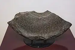
The earliest reference to Dvaravati on stone is the Wat Chanthuek Inscription (N.M. 4; K.1009) from Pak Chong, Nakhon Ratchasima Province, in Sanskrit in the Pallava script, a south Indian type now more often called Late Southern Brahmi,[14]: 11 recording that a queen who was a daughter of the Lord of Dvaravati set up a stone image of the Tathāgata. Kannika Wimonkasem and Chirapat Prapandvidya date the script to about 550–650, Claude Jacques to the sixth century.[13]: 67–68 [27] What it shows about Dvaravati's extent is disputed. John Guy takes it to carry the zone well into northeastern Thailand; Skilling argues that calling the donor the ruler's daughter places the site outside Dvaravati and marks a marriage alliance with a neighbouring realm.[13]: 60, 81
Proto-Dvaravati: 1st – 5th centuries
The phase predates the 6th century[28]: 4 and is usually placed in the 1st to 5th centuries,[28]: 1, 9 though some scholars restrict it to the 4th and 5th.[3] Its sites lie mainly in the western Menam valleys: the unmoated settlement of Pong Tuek (พงตึก),[13]: 30 [29]: 46 proposed as one of the five capitals of Tun Sun;[30]: 52 the moated city of Mueang Uthong, sometimes identified as the centre of Chin Lin;[28]: 2 and Ban Don Ta Phet. Pong Tuek's place in this phase rests on Cœdès's chronology of 1928. He dated a small bronze Buddha found there to about the 2nd century on an Amarāvatī attribution, and a metal lamp to the 1st or 2nd, which made the settlement the earliest known Dvaravati site. Both have since been redated, the lamp to an early Byzantine origin of about the 5th or 6th century and the Buddha to the 8th, along with four further bronze Buddhas Cœdès had placed in the 6th.[31]: 23
The region was occupied from at least c. 1000 BCE. Between about 900 and 200 BCE the material record suggests growing participation in maritime exchange, possibly reaching present-day Taiwan, the Philippines and Vietnam, and settlement continued and expanded through the Bronze and Iron Ages;[28]: 2–4 by the 1st or 2nd century CE contacts extended to South Asia, China and lands further west.[28]: 3, 4 [31]: 23 Finds at several sites have been read as evidence of exchange networks tied to Funan,[28]: 3, 4 though the political relationship remains debated.[28]: 3 The cemetery of Ban Don Ta Phet in Kanchanaburi province, 25 km south of U Thong and radiocarbon-dated to the late centuries BCE, shows their reach. Excavated by the Fine Arts Department from 1975 and by a Thai–British team under Glover between 1980 and 1985, it yielded over a thousand iron tools and weapons, more than any other reported prehistoric site in Thailand, with glass and etched carnelian beads, high-tin bronze bowls, a jade nephrite ear pendant of Sa Huỳnh type thought to come from Taiwan, a Dong Son bronze situla, and figurines of a haṃsa and a peacock pointing to contact with Indian religious traditions.[13]: 15–16, 19, 22
In the eastern plain, the Sup Champa site (เมืองโบราณซับจำปา) in Lopburi Province points to a complex society by about 500 BCE,[29]: 49–50 but it is too little excavated for its regional role to be established. By the 5th or 6th century CE Mueang Uthong still held its central place, while Nakhon Pathom was growing alongside it.[16]: 39–40 From approximately the 6th to the 10th centuries CE, Nakhon Pathom is widely regarded as a supra-regional center of the Dvaravati cultural sphere,[32]: 8–9 [33]: 55 alongside other major centers such as Si Thep in the eastern plain.[34]: 151–2
Origin traditions and migration narratives
The Tai Yuan Legend of Singhanavati calls the lower Menam Basin before the Dvaravati period Lava-rāṣṭra (ลวรัฐ; lit. 'land of the Lawa people'),[35]: 33 [36]: 60 meeting Yonok around the mouth of the Ping River.[35]: 37 This fits Gordon Luce’s view that the Lawa once held much of central Thailand as far south as Lopburi, an argument resting on a supposed link between Lavapuri of the seventh-century Lavo Kingdom and the ethnonym Lawa.[37]
The same text records continuing dealings between Tai Yuan and Lawa or Lua groups from the founding of Yonok,[35]: 32, 41–2 the first ruler Singhanavati subduing several existing settlements, some of them implicitly Lawa.[35]: 32 Marriage followed: the third Yonok king, Achutraraj (พญาอชุตราช), took a Lawa princess of Doi Tung as chief queen,[35]: 36–7 and their son succeeded him.[35]: 49 The Lawa town of Wiang Phang Kham served the Singhanavati kings as their base in the campaign to recover Yonok from Umongkasela in the late 4th century.[35]: 73–4
Late in the Yonok period Chaiyasiri is said to have faced invasion by the Mon kingdom of Thaton, and in 444 CE to have led some 100,000 households south into the upper Chao Phraya basin, founding a settlement at present-day Kamphaeng Phet.[35]: 90–3 No relationship has been shown between this narrative and the earliest epigraphic occurrence of the ethnonym syam, in the Funan inscription K.557 of 611 CE.[38]: 21 From a separate tradition, the Tang Huiyao and the Cefu Yuangui record an independent polity, Duō Miè, small in extent but populous, lying against the western border of Dvaravati's Tou Yuan, which was centred either at Lopburi or at Si Mahosot.[39][40]: 20 The migration story also shaped later reconstructions of Tai-speaking movement, which posit two routes, one from the northwest by way of the later Möng Mao[41]: 5 and one from the northeast by way of Muang Then.[41]: 3
Western accounts of the Ayutthaya period record that King Phrom of the Singhanavati dynasty, father of Chaiyasiri, was held to be Ayutthaya's first monarch. Jeremias van Vliet, Guy Tachard and Simon de La Loubère report the belief as widespread and reinforced by court tradition under Maha Chakkraphat, Prasat Thong and Narai, which traced the royal line to Phrom.[42] It has also shaped readings of the Burmese chronicle Hmannan Yazawin, which records that in 1056 the Gywans of Ayoja, or Arawsa, southeast of Thaton,[43] attacked the Mon centre there.[44][45]: 25 George Cœdès identified Ayoja with Ayodhya or Siam;[46] Francis H. Giles took the Gywans for descendants of the Tai Yuan.[47]
Early Dvaravati: 6th – 9th centuries
Pre-Dvaravati communities grew denser[28]: 3, 9 and larger,[14]: 8 developing without a break until the major religious monuments of the early and middle Dvaravati period, built between roughly the first half of the 7th century and the first half of the 9th.[28]: 9 The phase is often described as one of competition between two supra-regional centres, Nakhon Pathom in the western valley and Si Thep in the eastern plain,[48] and after reported Chenla incursions in the 7th century several Dvaravati polities are thought to have been drawn into wider conflicts.[11]: 54–5
A 7th-century marriage between a Tai Yuan princess and the Mon prince of Lavo has been proposed, said to have produced King Sai Thong Som.[49]: 5 The Laotian Legend of Khun Borom has Khun Borom, whom David K. Wyatt tentatively placed in the 7th century,[50] send his nine sons to found domains of their own. One, Khoun Kôm (ขุนกม or ลกกม), founded Indaprasthanagara,[51]: 5 which the Ayutthaya Testimonies place east of Sankhaburi in the Phraek Si Racha region;[52]: 5–6 another, Ngua In (งัวอิน), founded Ayutthaya.[51]: 5
Both attributions are hard to reconcile with the Legend of Singhanavati, in which Indaprasthanagara already exists under Phrom of Yonok (r. 379–438): Phrom drives the forces of a vassal of Umongasela south towards present-day Kamphaeng Phet, and they flee to Indaprasthanagara in the Chao Phraya basin,[35]: 82 an area the same text counts as part of Lava-rāṣṭra.[35]: 33 [36]: 60 The site of modern Ayutthaya before the 9th or 10th century, moreover, is described as low-lying swamp flooded each monsoon to about four metres above the dry-season level,[53]: 44–6 and so unfit for settlement.
Rivalry among Dvaravati polities
Rivalry between regional centres such as Nakhon Pathom and Si Thep has been proposed, and later local traditions are commonly read as reflecting it, though interpretations differ.
Support for competition among the largest centres has been drawn from the moats themselves. Eight of the moated settlements of the central plain were enlarged, and five of these are either a regional centre or that centre's nearest neighbour.[32]: 19–20 Before Nakhon Pathom added the second moat that took it to 602 ha it enclosed about 300 ha, close to Suphanburi and to the 315 ha Phraek Si Racha reached after its own enlargement from 81 ha. Mudar suggested that if the three stood at that size at the same time they may have been the capitals of competing polities, and that Nakhon Pathom's doubling marks the outcome; the expansions have not been dated against one another, which the argument requires.[32]: 11, 19–20, 24
The earliest narratives of conflict survive in versions of the Legend of Nakhon Chai Si and the Legend of Phra Praton Chedi. In these, Siddhijaya came from Manohana[54]: 11–2 [49]: 3–4 (a name identified with Ayojjhapura in the Pali Ratanabimbavaṃsa and Jinakalamali,[49]: 4 and in turn with Si Thep[2]) to the Nakhon Pathom region and took power there about 590 CE,[54]: 11–2 defeating a ruler already in place, Kakabhadra.[49]: 2 His rule may have run into the early 7th century: a Dvaravati mission to the Chinese court in 616 is entered under Tou-he (投和國) with the ruler named Pu-xie-qi-yao (脯邪乞遙), compared phonetically with Siddhijaya.[16]: 130 Tradition, against this, has Kakabhadra holding parts of the region until 641, when his elder son Kalavarnadisharaja succeeded him,[54]: 12 which has prompted the suggestion that the two names denote one man.[49]: 4


Later tradition has Brahmins from Nakhon Pathom ordered about 629 CE[b] to found a new city in what is now Lopburi, south of Si Thep,[54]: 11–4 completed in 648 with Kalavarnadisharaja, son of Kakabhadra, as its first ruler, which these sources treat as the founding of the Lavo Kingdom.[55][56] The Northern Chronicle makes his reign one of expansion[55]: 25 reaching Chiang Saen in northern Thailand, where he is said to have held influence and formed dynastic ties with Tai Yuan rulers.[49]: 4 The traditions say nothing of his dealings with Si Thep,[55]: 25 ruled in the 6th and 7th centuries by the line attested in the Ban Wang Pai inscription (K.978)[57]: 17–9 and later linked in the Jinakalamali to Rajadhiraj,[2] a king of Ayojjhapura.[58]: 97, 125–6 The foundation story cannot be reconciled with the Cāmadevivaṃsa, in which Lavo in 647,[59]: 19 a year before Kalavarnadisharaja's supposed accession, was already ruled by Navaratna (นพรัตน์),[59]: 23 a king without an heir who adopted Camadevi and married her to Ramaraj,[59]: 17 a prince of Ramburi whom some Thai scholars identify with Kalavarnadisharaja. Xuanzang likewise knew Lavo as Luó-wō-guó (罗涡国) by 629,[60]: 83 and some sources put its foundation as early as 538.[61]: 34
Authority in the Menam basin seems to have been reordered after the last tribute mission credited to Dvaravati, the Tou-he kingdom (投和國) of Chinese records, in the Zhenguan period (貞觀, 627–649).[62] Reading the Chinese sources, Tatsuo Hoshino puts the shift as early as about 665, when Pú jiā yuè mó,[13]: 133 associated with Si Thep, is said to have brought both the Si Thep and Nakhon Pathom regions under one authority.[11]: 54 It did not hold. Within the same century the Jinakalamali has Anuruddha, ruler of Arimaddanapura, often taken to be Nakhon Pathom, campaign against Ayojjhapura or Si Thep and carry off its ruler Manohanaraj,[49]: 4 and the Northern Chronicle has him press on towards Indaprasthanagara in the Phraek Si Racha region.[63]: 88–91 The tribute sequence had begun in 638 with an embassy arriving without Linyi, through which most South Seas missions then passed; the Cefu Yuangui notes at this first appearance that the state belonged to the Kunlun category. Missions followed in 640, 643 and 649, and in 643 and 647 embassies also came from Tuoheng, which the Jiu Tang shu calls a dependency of Dvaravati.[13]: 128–129 In 649 the ruler sent ivory and fire-beads and asked for fine horses, Tuoheng having asked for horses and a bronze bell two years before. Lin Ying and Huang Jiaxin note that such requests were unusual where return gifts were normally silk, the only recorded grant of horses to a South Seas polity under the Tang being two sent to the king of Linyi in 713, and read Dvaravati's willingness to ask as a mark of the standing of a polity by which Chinese sources routinely located others.[13]: 128–129
Late in the 7th century, by the Legend of the Arhat (ตำนานนิทานพระอรหันต์), Balidhiraja, eldest son of Kalavarnadisharaja of Lavo and ruler of Sukhothai, marched south into the western valley, deposed its ruler and installed his youngest son Sai Thong Som, said to be of mixed Mon and Tai descent, while his elder son Balipatijaya took Lavo about 700 CE.[49]: 3–5 A ruler called Padumasuriyavamsa then appears at Indaprasthanagara in the central Menam valley[c] by 757.[d] Later traditions give him Lavo and Sukhothai and a reach east across the Korat Plateau as far as Mueang Talung (เมืองตลุง or ตะลุมดอ) in present-day Prakhon Chai district,[66]: 8 and several later Siamese monarchs claimed descent from him.[65][52]: 11, 38, 43–4 [67]: 127, 133 The Legend of Mueang Phaya Re (ตำนานเมืองพญาเร่) gives the city's revival differently, to King Sudarśana (สุทัศน์), who rebuilt it as his capital in the same year.[68]: 127 An 8th-century terracotta Buddha from Mueang Uthong carries the name of a King Maratha (มะระตา) and nothing further, so how he or his polity stood to the other centres cannot be determined.[69][70]: 253
In the early 9th century the Ratanabimbavaṃsa has Adītaraj of Ayojjhapura, that is Si Thep, besiege Indaprasthanagara after the death of its great ruler.[2][71]: 51 The Si Thep line remained a regional power, as Bhagadatta shows, his reign dated from 859 CE by the Śrī Canāśa Inscription (K.949),[72]: 122 and is said to have lasted until 949, when incursions from Angkor ended it.[73]: 3546 A possible ethnographic trace survives among the Nyah Kur people of Thep Sathit District, next to Si Thep in southern Phetchabun Province. They speak an archaic Mon-related language carrying Khmer loanwords,[e] and their oral traditions tell of ancestors driven into the highlands after Khmer seized their settlement. Their spread across the borders of Phetchabun, Lopburi, Chaiyaphum and Nakhon Ratchasima has been linked to the expansion of Angkorian influence in the 10th and 11th centuries,[74]: 77–80 and Khmer ceramics and Chinese Song dynasty celadon from the highland zone attest activity there between the 10th and 12th.[74]: 83
After Adītaraj's campaign, the Northern Chronicle and the Ratanabimbavamsa have Bhūpati (ภูบดี) of Vajraprākārapura (วชิรปาการปุระ, modern Kamphaeng Phet), on good terms with both Ayojjhapura[63]: 101 [71]: 52 and Ngoenyang Chiang Rai,[63]: 104 send a son whose regnal name is not recorded to rule Lavo Lavapura,[63]: 101 which had been under Indaprasthanagara since Padumasuriyavamsa's reign.[66]: 8 The Ayutthaya Testimonies make Vajraprākārapura itself a foundation of one of Padumasuriyavamsa's descendants.[52]: 11 A few decades later the Jinakalamali and Cāmadevivaṃsa bring in Uchitthaka, a cakravartin who lost Lavapura to Sujita of Tambralinga in 927 CE in a campaign bound up with Haripuñjaya, then marched north, took Haripuñjaya and ruled there until 930.[75] Local ruling lines in the upper, central and western regions appear to have lasted into the late 10th and 11th centuries[16]: 262–3 before pressure and invasion from Pagan,[17]: 41 [20]: 4 Tambralinga,[76]: 70 Angkor,[77] Chola[8]: 143 and Ngoenyang Chiang Saen.[63]: 17–8
Khorat Plateau and Middle Mekong region

The Khorat Plateau and the middle Mekong, east of the core Dvāravatī centres, appear not to have belonged to the Dvāravatī political network but to have developed as a loose landscape of small fortified and moated settlements. Working from the site inventories of Thiva Supajanya and Srisakra Vallibhotama, Charles F. Keyes argued that local traditions, above all the legend of Phadaeng Nang Ai and the Tamnan Fa Daet Song Yang (ตำนานฟ้าแดดสงยาง), preserve the names of early settlements there.[78]: 497–8 One of these is Mueang Fa Daet Song Yang, the first site in northeastern Thailand identified as "Dvāravatī" by H. G. Quaritch Wales,[78]: 502 and traditionally attributed to the foundation of Chao Fa Ra-ngum in 621 CE.[79] Keyes warned against applying "Dvāravatī", "Mon" or even "Buddhist" uncritically to the plateau.[78]: 504 The traditions show instead a fragmented landscape of largely autonomous muang, some holding subordinate settlements and others independent, and Buddhist practice alongside fertility cults and local spirit beliefs coloured by Hindu deities.[78]: 504–5 The region's sema stones, Buddhist boundary markers, show the same mixture. Narrative carvings from Mueang Fa Daet Song Yang and Ban Nong Chat, generally dated to the 7th to 11th centuries and counted as Dvāravatī work, depict jātaka scenes and the life of the Buddha while marking the consecrated ground needed for ordination and other formal rites.[80]: 352–4 An earlier theory took this tradition to have been carried to the Kalyāṇī sīmā at Thaton in lower Myanmar by Mon fleeing Angkorian expansion in northeast Thailand; more recent comparison finds substantial differences of form, composition and style between the two corpora, and suggests that the lower Myanmar tradition developed independently.[80]: 352, 371
Epigraphic and Chinese evidence agrees with Keyes in showing the plateau divided among many small polities between the 6th and 9th centuries, several inscriptions naming local rulers or nobles as religious donors. The Sanskrit Phimai Inscription No. 1 (K.1000) of the 7th or 8th century names a Buddhist ruler, Sauryavarman, in the Phimai region;[81] the Hĭn K‘ôn inscriptions (K.388 and K.389) a Buddhist noble, Nrpendradhiphativarman, with his similarly named father;[82]: 77 the Don Mueang Toei inscription King Pravarasena of Śaṅkhapura;[83]: 83–4 the Wat Ban Waan inscription (ศก. 13) King Srimanya;[84][85]: 275 and the Wat Pa Nong Peng inscription King Śrīmānarājā, whose reign it describes as a time of political turmoil.[84]: 275 [86] Together they attest multiple local polities before Angkorian authority arose to the south.
During roughly the same period, corresponding to the reign of Mahendravarman of Chenla (r. 600–615), parts of the Khorat Plateau may have come under temporary Chenla influence. Victory inscriptions of Mahendravarman are spread across the Mun–Chi basin from Dong Mueang Aem in present-day Khon Kaen Province to the Phimai region and the mouth of the Mun in Ubon Ratchathani province.[87]: 49 One (K. 969 / P.Ch. 5), from Prasat Khao Chong Sa Chaeng in Ta Phraya district, Sa Kaeo province, records the digging of a water tank, the Śaṅkara Taṭāka, carrying the pattern south of the Dângrêk range, while others place him up the Mekong as far as Champasak in southern Laos.[31]: 50 These were long read as evidence of Chenla administering conquered territory through vassals. Since they proclaim victories without indicating lasting control, Michael Vickery argued that they do not show direct Chenla authority beyond the Dongrek Mountains,[88]: 462 [82]: 76 [89]: 79 the campaigns being temporary expeditions of limited political effect,[31]: 50 after which regional inscriptions name no ruler from the Tonlé Sap basin for several centuries.[87]: 103

A firmer connection with Chenla may date from the reign of Isanavarman I (r. 616–637), Chinese records placing a polity called Bhīmapura under him which some identify with Vimayapura, Phimai.[7]: 49 Others read Chinese accounts of Zhu Jiang and Can Ban as allies of Chenla by marriage to mean that polities of the central plateau and upper Pa Sak basin formed dynastic ties with his court.[90] Much of the plateau seems to have lain where the Chenla and Dvaravati spheres overlapped, but its northeast, covering present-day Nakhon Phanom and Sakon Nakhon with Khammouane province in Laos, appears in Chinese sources of the early 7th century as a Tang division of two districts, Changzhou Prefecture (長州 or 裳州).[11]: 49–51 Hoshino has proposed that the early Tai polities of Gǔ Láng Dòng (古郎洞)[11]: 49 and Jūn Nà Lú (君那盧)[11]: 60–1 were situated within this region. However, Changzhou is not mentioned again in the Chinese records after the emergence of Wen Dan, although the relationship between the two remains unclear.
From the mid-7th century Chinese sources suggest Chenla's influence on the plateau weakening, with several polities appearing in the record on their own account. One was Zhān Bó, often placed at Champasri,[11]: 38 which sent tribute to China in 657 and may have formed by the merger of Zhān Guo (瞻國) and Bó Guo (博國).[11]: 47–8 Another, Pó Àn (婆岸) in the New Book of Tang, has been tentatively placed around modern Phon District.[11]: 30 Hoshino read Zhān Bó, Po An and several states of the Menam valley and the Cham coast as a trans-Mekong trade confederation[11]: 42 distinct from the Dvaravati polities of the coast.[11]: 30 Following the reign of Jayavarman I (r. 657–681), scholars have proposed that Wen Dan, a polity located in the central Khorat Plateau, separated from Chenla sometime between 681[7]: 123 and 707[7]: 59 before sending its first recorded tributary mission to China in 717.[11]: 41, 47 George Cœdès identified this polity with Mūladeśa,[91]: 87 a toponym attested in the K.187 inscription.[92]: 90 Chinese records further state that, in 755, Wen Dan assisted a native Nghean lord in the wars against the Chinese governor at Jiaozhou, which they won, conquering Jiaozhou, after which the native lord enthroned himself as Hei-ti (lit. 'Black Emperor'). Woodward has likewise suggested that Wen Dan's influence extended beyond the Khorat Plateau into the Si Thep and northern Tonlé Sap regions, where several pre-Angkorian Buddhist and architectural remains have been interpreted as reflecting connections with the Wen Dan cultural sphere.[91]: 87–94
References to the plateau grow rarer from the 9th century, Wen Dan's last recorded mission to China falling in 799. The plateau and much of present-day Laos are generally held to have entered the "Java Period" in the 9th century, as Angkor rose in the Tonlé Sap basin.[11]: 61–2 [91]: 93 Since Java also runs through the Angkorian foundation narratives,[21]: 56 what it denotes is much debated: the island of Java, Cham-related polities on the mainland, or other maritime powers of the region.[11]: 61–2 [21]: 56 [93]: 71–5 Woodward, surveying the same problem, adds the northern Malay Peninsula, a principality far up the Mekong, and Wen Dan itself to the proposals, and notes that the whole tradition has also been treated as a late myth.[91]: 93 Inscriptions of Jayavarman VII (r. 1181–1218) complicate it further, naming a "King of Yavana" beside a "King of Java" and two kings of Champa in one context, so that the terms denote distinct entities that remain unidentified.[93]: 62
Hunter Watson divides the Old Mon corpus of Thailand into three phases, of which the plateau represents the second, of about the eighth to tenth centuries and in a post-Pallava script. Most plateau examples are short texts on sema stones recording meritorious acts and donors' names. They come from Chaiyaphum, Khon Kaen, Udon Thani, Sakon Nakhon, more recently Phetchabun, and a Kalasin province group one of which is dated to 771 CE. Another has long been known from Vientiane province in Laos. Watson cautions that the distribution is not by itself evidence for Dvaravati's extent, since a site yielding such an inscription need not have been affiliated with it.[13]: 87–88, 92–93 Skilling has likewise suggested that the exceptionally large stone images from Wat Chanthuek and Sung Noen indicate a centre of power and wealth in the area of old Khorat in its own right.[13]: 81
That these religious systems reached small polities far inland is shown by a hoard of silver and gold found in 2008 at Nong Hua Thong in Savannakhet province, Laos, at a fortified settlement on the Xe Bang Fai. Broadly of the eighth to tenth centuries, it holds silver vessels in late Tang style, a silver Garuda and a repoussé plaque of a seated ascetic tentatively identified as Kubera; it is held by the provincial government and closed to study.[13]: 56, 59–60
Dvaravati–Chenla relations

Dvaravati polities of the Chao Phraya basin have been held to have kept dynastic ties with those of the Tonlé Sap basin and the Mekong Delta since the Funan period.[94]: 43 George Cœdès suggested that Chakravartin, the father of Prathivindravarman of Si Thep named in the Wang Pai Inscription (K.978), was Rudravarman, last ruler of Funan's Candravaṃśa line.[95]: 156–8 After the brothers Bhavavarman I and Mahendravarman I of the Suryavaṃśa line of Chenla besieged the Funan capital, Rudravarman is said to have fled to Champa and his kin to have scattered to polities such as Pan Pan.
Claude Jacques instead identified Chakravartin with Mahārājādhirāja Śrī Devanika, whom the early 5th-century Devanika Inscription (K.365) describes as having come from a distant land. On his reading Devanika ruled from Si Thep and sent princes to govern cities along the trans-Mekong trade route, perhaps Dong Mueang Aem in Khon Kaen province, Dong Muang Toey in Yasothon province and Vat Phou in southern Laos, the Vat Phou line being later identified as the founding line of Chenla.[96]: 68–9 Zakharova disputes the identification.[97]: 143
Cœdès and Jacques first dated the Wang Pai Inscription to the mid-6th century and took its Bhavavarman for Bhavavarman I of Chenla. Jacques later reread it as naming a local ruler of Si Thep.[94]: 37–9 Kangwon Katchima argues on epigraphic style for a date after 637, which would make the man Bhavavarman II or another local ruler rather than Bhavavarman I,[57]: 17–9 whose authority may have reached no further than south of the Dângrêk Mountains.[94]: 41 Anurak Depimai supports Katchima and adds that he cannot be Bhavavarman II either, since the Wat Kud Tae Inscription makes Bhavavarman II the son of Isanavarman I.[94]: 40–2

During the reign of Isanavarman I of Chenla (r. 616–637), attempts were made to extend influence into the Menam Basin, particularly toward the Tou Yuan Kingdom,[90][98] whose principal center has been proposed to correspond to modern Lopburi[11]: 36, 54 or Si Mahosot.[99] A local fable of the Chao Phraya valley ends the conflict in a marriage between a Chenla princess and a Dvaravati ruler.[100] Michael Vickery proposed separately that Harshavarman, who claims descent from Isanavarman as a grandson in the Copper Plate Inscription of Mueang Uthong and later ruled that polity, headed a branch of the Chenla house with a centre of its own in what is now central or eastern Thailand; the plate records the descent but not the marriage it would have come from.[31]: 51 Karen Mudar read the plate against the settlement record instead. U Thong's moat encloses 73.3 ha, a district centre in her four-level hierarchy, and on that footing she suggested the inscription may mark lost autonomy rather than a court.[32]: 8, 20, 25 Chenla under Isanavarman I also married into Champa[94]: 44–6 and into Dvaravati-sphere polities including Zhu Jiang and Can Ban,[101] and the art of the Menam basin, in the west especially, carries influence from both Chenla and Champa.[31]: 49–53 [94]: 44–6 Dvaravati is also recorded to have established a dynastic connection with a polity in the upper Mun Basin through the marriage of a Dvaravati princess to its ruler, as recorded in the Wat Chanthuek Inscription (K.1009);[94]: 48 Skilling has suggested, without deciding, that the polity may have been Cānāśa.[13]: 66, 81
After Isanavarman I's death his successor Bhavavarman II (r. 639–657) appears in the Wat Kud Tae Inscription at war with Dvaravati Sambuka, commonly identified with modern Nakhon Pathom.[102]: 24–25, 30 [103][104]: 10 Tatsuo Hoshino argued that these wars drew in several polities, among them Qiān Zhī Fú (later Gē Luó Shě Fēn), Xiū Luó Fēn and Gān Bì, the New Book of Tang giving 20,000 warriors each to Gē Luó Shě Fēn and Xiū Luó Fēn, 40,000 to the two together and 5,000 to Gān Bì.[11]: 46, 54–55 Tou Yuan, earlier a target of Chenla expansion, is recorded in 647 as a vassal of Dvaravati,[7]: 269 and the next year Kalavarnadisharaja (r. 641–700) of Dvaravati Nakhon Pathom founded or refounded the Lavo Kingdom.[11]: 54 During the reign of Bhavavarman II of Chenla, Dvaravati polities from the western Menam Basin are described as extending their influence eastward as far as the ancient town of Mueang Phai (เมืองไผ่) in modern Aranyaprathet district, which together with the area around Prasat Khao Noi probably corresponds to the polity named Jyesthapura in the inscriptions,[104]: 10 the former seat of Bhavavarman II between 637 and 639.[94]: 47 Two pre-Angkorian inscriptions name lords of Jyesthapura in the preceding decades. The badly worn Khao Noi inscription (K. 506 / P.Ch. 16), dated 637, records Vaiṣṇava dedications by Isvarakumara, svāmi of Jyesthapura and bhṛtya or servant of a king identified by Vickery as Isanavarman I and by Claude Jacques as Bhavavarman II; the undated Wat Kud Tae inscription (K. 1150 / P.Ch. 26) gives the same office to Sivadatta, a son of Isanavarman I and elder brother of Bhavavarman II.[31]: 50–1 This period of close contact coincides with a cluster of pre-Angkorian references to syam as toponym or ethnonym, in K.557 (611 CE), K.79 (639), K.127 (683), K.154 (685) and K.904 (713), where it names enslaved persons and at least one landholding official.[105]: 21, 69, 89, 123 [106]: 54 Scholars read it at this stage as probably a toponym for somewhere in the lower Chao Phraya basin.[107]: 69 It disappears from the record after Chenla fragmented in the early 8th century.
In the same period the country northwest of the Tonlé Sap, south of the Dângrêk Mountains and around present-day Battambang Province, is described as breaking into four polities that sent their own embassies to China after leaving Chenla,[94]: 48 and by the 720s as falling under Wen Dan, a polity of the Dvaravati sphere. Two sets of Buddhist boundary stones (Bai sema) on Mount Kulen were originally proposed as Wen Dan foundations of the 8th century, an argument its author later withdrew as incautious on the ground that the stones cannot be dated closely enough to establish whether they precede or follow Jayavarman II's accession in 802;[91]: 88 the case now rests chiefly on the scarcity of inscriptions and the apparent cessation of monumental building across the Angkor region from about the 720s.[91]: 90 Based on this evidence, Hiram W. Woodward suggested that the northern Tonlé Sap region during this period was not under the authority of Lower Chenla but instead formed part of the sphere of Wen Dan,[91]: 87–8, 91 which maintained close relations with,[91]: 91–2 or exercised authority over, Si Thep.[91]: 94 Population movements from this region toward Si Thep in the early 8th century are also described as occurring under the auspices of Wen Dan.[91]: 91
The Tonlé Sap polities were then reunified, moving their principal centre north to the Angkor region in the early 9th century.[108] Jayavarman II (r. 780–850), ruler of Lower Chenla and later counted the founder of the Angkorian monarchy, is recorded renewing relations with the Mun–Chi basins, where the former ally Zhu Jiang lay, and meeting Dvaravati Si Thep in the Menam–Pa Sak valleys. Woodward has further proposed that Jayavarman II defeated Wen Dan during this period, after which the remaining Dvaravati-associated Wen Dan region in the Chi valley entered the Javā era.[91]: 93 Archaeological and textual evidence suggests that Dvaravati's political predominance was already declining by the early 8th century.[54]: 60 Angkor under Rajendravarman II (r. 944–968) took Si Thep in 946,[f][109] after which the city declined and was abandoned by about the 13th century, as Sukhothai and Ayutthaya rose.[110] Lavapura of Lavo came under Angkorian influence from the 10th century[14]: 23 and under Angkorian authority in 1005, under Suryavarman I (r. 1002–1050),[19] who also recovered polities lost to Dvaravati since the 8th century, Jyesthapura in present-day Sa Kaeo Province and Candhrapura in Chanthaburi Province, and took the former Dvaravati vassal Avadhyapura in Prachin Buri Province.[104]: 10–4
Si Thep dominance
After Chenla fragmented in the early 8th century, Si Thep was then the principal regional power left in the Menam basin. Chinese records place a polity called Qian Zhi Fu (千支弗)[111] at Si Thep in the eastern-central plain, sending its first tribute to the Chinese court about 656–661 under Emperor Gaozong of Tang.[11]: 30, 32 The same passage names Duō Mó Cháng (多摩長) as its northern neighbour, and it is Duō Mó Cháng, not Qiān Zhī Fú, that the annals credit with an army of 20,000 men without horses and a territory traversable in a month from east to west and twenty-five days from north to south.[11]: 30 Tatsuo Hoshino places Duō Mó Cháng in the river country of present-day northern Thailand, later the Lan Na sphere, which would put Qiān Zhī Fú's northern limit in the upper Menam basin.[11]: 31–4, 60
By the 8th century Chinese sources add Gē Luó Shě Fēn (歌羅舍分), placed west of Dvaravati.[11]: 38–9 It has been tentatively identified with Qiān Zhī Fú, partly on its phonological match with Jiā Luó Shě Fú (迦逻舍佛), which Hoshino centres at Si Thep with Mueang Sema as a subordinate rather than the seat.[11]: 32–4 On that reading the change of name marks Si Thep's reach spreading over much of the lower Chao Phraya valley, including the former Dvaravati centre at Nakhon Pathom, while Lavo to the east stayed within the older Dvaravati network.[11]: 38–9 Hoshino further took Qiān Zhī Fú for an early Siamese polity, one of several that prospered on the trans-Mekong routes linking Champa with the Menam basin,[11]: 54 supported in part by the resemblance of qiān (千) to the later xiān (暹), the term Chinese and Đại Việt sources use for the Siamese polities of the lower basin.[112]: 37–9
Hiram Woodward reaches a comparable picture from art history rather than the Chinese texts, and from a different premise, that Si Thep itself lay within Wen Dan. A Si Thep strong enough to dominate the 8th century may, he suggests, have held not only Lopburi, which the reading above places outside its sphere, but Nakhon Pathom, U Thong and even Khu Bua further west. Central Dvaravati might then divide into pre- and post-Wen Dan phases. He offers this as a possibility, with the alternative that the Dvaravati features at Si Thep came from a peaceful movement of monks before Wen Dan's rise rather than from conquest.[91]: 93 On Hoshino's identification of Chinese toponyms other than Wen Dan with Si Thep, which the reading above rests on, Woodward reserves judgement and holds that historical geographers who know the Chinese texts will have to review the evidence.[91]: 92
The proposed expansion of Si Thep's sphere is also consistent with a lapse in the later dynastic traditions of both upper and lower basins. The tradition records Sai Thong Som at Nakhon Pathom and his brother Balipatijaya at Lavo as the last recorded rulers of this line, but names no successors.[49]: 3–5 The only later ruler associated with the area is known from an inscription: K.577, found at Lopburi and dated to the 8th or 9th century, identifies Nāyaka Ārjava as a son of the king of Sambuka,[113] a name several scholars have associated with Nakhon Pathom.[102] The tradition records no successor to Balidhiraja at Sukhothai either,[49]: 3–5 leading some local scholars to suggest that the city was abandoned.[76]: 8 Hoshino's reading of the Chinese records instead places the area within the territory of Qiān Zhī Fú, extending northward to the mountain range.[11]: 31–4, 60 These dynastic gaps fall within the period in which Si Thep has been proposed to have extended its influence across the Menam basin, although no study has explicitly connected the two.
By the 9th century, Indaprasthanagara, situated in the central plain between Nakhon Pathom and Si Thep, had entered a period of instability marked by rapid succession. The chronicle describes a major flood followed by an attack from Ayojjhapura,[114]: 94 [71]: 51 which some scholars identify with Si Thep,[2] after which much of the population dispersed.[114]: 94 [71]: 51 Meanwhile, epigraphic evidence indicates continued political activity in the Si Thep region through the 9th and early 10th centuries, with the Śrī Canāśa Inscription (K.949) recording Bhagadatta and his successors from 859 CE.[72]: 122 Si Thep's dominance potentially ended with its conquest by Angkor in 946.[73]: 3546
Late Dvaravati: 9th – 11th centuries


Economic and archaeological transformations
Some scholars date this period to the 9th and 10th centuries,[28]: 3 others carry the Dvaravati cultural horizon into the 11th.[28]: 6 Economic conditions in the western Menam valley changed,[28]: 9 and trade with the Tang dynasty along Maritime Silk Road routes is attested,[28]: 9 while the valley polities suffered the incursions the sources associate with the end of the Dvaravati period in the 11th century. Survey around the former centre at Mueang Uthong shows low settlement density in this phase[28]: 4 and abandonment in the 12th century,[28]: 3 though trade between U Thong and Tang China in the 9th and 10th is documented.[28]: 5 Against this contraction, Tambralinga's conquest of the lower Menam basin in the early 10th century shifted the balance: Nakhon Pathom, identified as Mevilimbangam, prospered on maritime trade as Srivijaya rose, with little political weight,[54]: 60 and local traditions call the city Śrīvijaya,[80]: 25 while Lavo rose as a regional centre under Angkorian control from the 11th century.[16]: 262–3 [116]: 46
Regional power reconfiguration
After Tambralinga briefly took Lavo[g] in 927[75] and Angkor annexed Si Thep in 949,[73]: 3546 authority over the Sukhothai region named in the Northern Chronicle seems to have passed to Haripuñjaya kings in the 950s.[117]: 6–10 [63]: 8–10 Several Dvaravati polities were attacked or displaced in these years. The Yonok Chronicle has Suphannaphum in the western Menam valley assaulted in the 930s, its two princes fleeing north into Haripuñjaya,[114]: 191 while Tambralinga campaigns launched from Lavo towards Haripuñjaya all failed.[118] In the same years the Ayutthaya Testimonies has Sudhammaraja move the centre of the early Siamese polity north from the central Menam valley to Phitsanulok in 937.[52]: 37 By the mid-10th century, Lavo itself is said to have come under the authority of Indaprasthanagara, a transition associated with the tradition of Sricandradhipati, described as a commoner from Lavo who rose to become ruler of Sukhothai in 959.[63]: 27–9 Later in the same century, Ipoia Sanne Thora Thesma Teperat is said to have transferred his seat of power from Indaprasthanagara to Lavo's Lavapura.
By circa 1001–1005, Lavo had fallen under Angkorian authority during the reign of Suryavarman I,[119][19] prompting the Siamese monarch Visnuraja at Phitsanulok to relocate southwestward to Phetchaburi.[52]: 38 The main evidence for the campaign is the Khmer inscription K.1198 of 1014, now in the National Museum of Cambodia, recording the career of Lakṣmīpativarman, a general charged by Suryavarman I with governing Rāmanya, a form of Rāmañña denoting the Mon, "who occupy the western region". Its Sanskrit verses lament that Lavapura had been reduced to jungle by the defects of the Kali Age and state that its long-abandoned western districts were to be restored and repopulated. U-tain Wongsathit and his co-authors, publishing the Sanskrit portion in 2019, read one campaign running from Angkor by way of Phanom Rung and Phanom Wan, where a rebellion of two local families was put down in 1011, to Lavapura, and call it the first explicit epigraphic notice of Dvaravati falling to a Khmer army; on their reading the conquest falls between 1011 and 1014 rather than at the century's opening.[13]: 137, 139–141 Walailak Songsiri rejects the chain of identifications that reading rests on. The earliest attested Mon form, rmeñ, occurs in an inscription of Kyansittha of Pagan dated 1102, nearly a century after Suryavarman I, and the Middle Mon rman was probably taken from Pali by way of Haripuñjaya, while the ramañ of the pre-Angkorian Prasat Bassac inscription (K.71) is a slave's name.[120]: 3 She adds that the inscription calls the region Madhyadeśa, that Lakṣmīpativarman's family came from the Mekong basin in the east, that inscriptions at Lavo about ten years later record accommodation between Brahmanical and Mahayana practice, that none describes a war leaving the country deserted, and that no Angkorian inscription of the whole period records a western campaign on the scale of the wars with Champa.[120]: 2–3 In 1052, the Angkorian ruler at Lavo was defeated by a king of Haripuñjaya, who installed his younger brother Chandrachota as the new ruler;[121][122] shortly thereafter, the Siamese ruler Srisimha returned from Phetchaburi to the central Menam valley.[52]: 40 The Burmese chronicle Hmannan Yazawin records that in 1056 the Gywan warriors — described as descendants of the Thai Yuan[47] and located by the chronicle in a southeastern land called Ayoja[43] — marched against the Thaton kingdom, then in the process of annexation by Pagan, an episode corroborated by Burmese inscriptions from the Arakan Pagoda in Mandalay.[44] The chronicles of Thaton likewise mention an attack by the Krom, with both ethnonyms likely referring to the Khom people.[45]: 25 George Cœdès proposed that Ayoja corresponds to Ayudhya or Siam.[46]
Events at Angkor shaped the region too. The Mahidharapura line of the Phimai region lost Angkor and Preah Vihear to Suryavarman I about 1010 in a succession struggle, and the rival claimant Jayavirahvarman withdrew towards Phimai, where an inscription of 1008 records his donation to the god Vimāya after the loss of Angkor.[13]: 138–139 [123][124]: 120–1 Readings of the Preah Vihear inscription suggest the ruling elite was then stripped of authority, some scholars proposing a displacement into what is now upper northeastern Thailand.[125] The line reappears in the north late in the following century, and here the evidence is epigraphic rather than chronicle. Pha Mueang, lord of Mueang Rad, received from the ruler at Angkor a Khmer title, a regalia sword and a princess in marriage.[14]: 35 The princess is named Sukhara Mahadevi and associated with the court of Jayavarman VII, and the marriage has been read as the means by which the displaced line recovered standing in the region through the Tai Lueang (ไทเลือง) house.[126]
These northern developments met events in the upper Menam valley. The Northern Chronicle has a coalition of Tai Yuan mueang under Śrīdharmatripiṭaka (ศรีธรรมไตรปิฎก) of Ngoenyang Chiang Saen move south during the reign of Suvacanaraja of Mueang Chaliang, which began about the 1050s. The conflict was settled by negotiation and by Suvacanaraja giving his only daughter to Śrīdharmatripiṭaka in marriage,[63]: 17–8 who is also credited with rebuilding Phitsanulok.[63]: 19–24 In the lower basin the death of Narai of Ayodhya in 1087 without an heir set off a two-year succession war among nine royal houses, won by Phra Chao Luang.[63]: 40–2 [122] Śrīdharmatripiṭaka is said to have moved from Chiang Saen to Phitsanulok in 1106 and ruled there until his death.[127] Scholars generally assign these campaigns to a later period[127] than the text's own date of about 1500 BE (957/58 CE).[63]: 23
The union of the Śrīdharmatripiṭaka and Suvacanaraja houses is said to have produced two princes, the elder of whom, Kesariraja, became ruler of Lavo,[63]: 18 his reign generally dated from about 1106.[127] A son of his, Duangkrian Krishnaraja (ดวงเกรียนกฤษณะราช), is said to have married a Xiān princess, a daughter of Phra Chao Luang (r. 1089–1111) of Ayodhya,[63]: 23–4 [117]: 104 extending the ties between the northern Tai Lueang houses and the Siamese polities downstream. From the late 12th to the mid-14th century a Tai Lueang house traced to Sri Naw Nam Thum appears to have held the upper eastern Menam valley, above all the lower Nan River basin in Uttaradit and Phitsanulok province. It passed to the Xiān line of Si Inthrathit under Maha Thammaracha I,[128]: 9 who is said to have moved the capital from Sukhothai to Phitsanulok in 1349.
Against this background, the traditions of the middle Mekong and Khorat Plateau have been discussed in relation to the proposed displacement of members of the Angkorian Mahidharapura ruling elite mentioned above.[125] These traditions consistently refer to regional rulers as Phaya Khom (พญาขอม), an epithet commonly associated with rulers of the Angkorian sphere, and preserve accounts of political relationships among the principal muang of the region.[78]: 503
Power networks of Khorat Plateau and Middle Mekong
The middle Mekong and Khorat Plateau long formed a transitional zone between the Dvāravatī sphere and the pre-Angkorian polities. Wen Dan last sent an embassy to the Tang court in 799 and then leaves the record, as Angkor became the dominant power and, on the archaeological evidence, the middle Mekong was drawn into its sphere from about the 9th century. Contemporary written sources are scarce thereafter, so later local traditions carry much of the weight in reconstructing the region between Dvāravatī and Angkor.
Among these traditions, the Urangkhathat (ตำนานอุรังคธาตุ), the foundation legend of Phra That Phanom, preserves the broadest account of the political geography of the middle Mekong.[129] Its political network has been dated to the 10th century and after, chiefly from the earliest architectural phase of Phra That Phanom's stupa, which predates the later Lao and Isan renovations.[80]: 18 The Urangkhathat presents not a unified kingdom but a network of connected polities. Its centres are Sri Kotabun (ศรีโคตรบอง), Nong Han Luang (หนองหานหลวง), identified with Sakon Nakhon, and Nong Han Noi (หนองหานน้อย) or Khun Khom Nakhon (ขุนขอมนคร), in the Kumphawapi area of Udon Thani province. It sets these centres in a wider landscape reaching Candrapuri (Vientiane), Sri Sattanak (Luang Prabang), Chulani Phromathat, associated with the Cham polity at modern Huế, and Indaprasthanagara, whose location is disputed.[129] That chronology places this world in the transition during which Dvāravatī influence receded and Angkorian integration moved north across the middle Mekong.
Within this political landscape, the Urangkhathat assigns particular prominence to Saket Nakhon Roi Et Pratu (สาเกตุนครร้อยเอ็ดประตู; lit. 'Saket, city of a hundred-and-one gates'), describing it as a paramount centre paired in status with Yothika (โยธิกา), or Kurunta (กุรุนทะ), or Ayodhya in the Menam Valley.[129] Its ruler, Phaya Suriyawongsa Sitthidet, is read as holding ritual overlordship over subordinate polities whose rulers acknowledged him by presenting gold and silver flowers each year.[130] "Roi Et", a hundred and one, is generally taken as a symbol of pre-eminence rather than a count of dependent towns,[130] and "Saket", an Indian toponym tied to Ayodhya in Hindu, Buddhist and Jain tradition, as borrowed sacred geography legitimising regional kingship rather than evidence of contact with India.[130]
A more localized account of political organization on the northern Khorat Plateau, focused specifically on the Nong Han–Sakon Nakhon area already named in the Urangkhathat, survives in the legend of Phadaeng Nang Ai. The legend portrays a monarch known by the common epithet Phaya Khom (พญาขอม) as the ruler of Muang Nong Han. Charles F. Keyes, followed by some later local traditions, identified this polity with present-day Nong Han in Udon Thani Province. Both Nong Han Udon Thani and Nong Han Sakon Nakhon have rectangular, Angkorian-style moated plans. The earliest Lao accounts, however, anchor the Phaya Khom narrative to the Sakon Nakhon site, against the reading that ties the legend to Udon Thani. According to these accounts, Phaya Khom appointed his two sons to govern Muang Chiang Hian–Ban Iat (เมืองเชียงเหียน–บ้านเอียด, in present-day Mueang Maha Sarakham district) and Muang Si Kaeo–Phak Waen (เมืองสีแก้ว–ผักแว่น, in modern Changhan district), while his two grandsons were assigned to rule Muang Hong–Muang Thong (เมืองหงส์–เมืองทอง, in Chaturaphak Phiman district) and Muang Pheng (เมืองแพง, in modern Ban Phaeng in Kosum Phisai district), a structure the legend preserves.[78]: 498–503 Some versions of the legend also incorporate Muang Fa Daet into this dynastic network.[131] The final episode has Phaya Khom's Muang Nong Han sink beneath the water.[78]: 500 That fits Sakon Nakhon better than Nong Han in Udon Thani, since the northern sector of the old moated city at Sakon Nakhon lies low and floods seasonally. The Urangkhathat attaches the same submersion motif to Khun Khom Nakhon in its account of Nong Han Noi.[129] Beyond the dynastic successions and inter-polity relations they state, these traditions have not been systematically interpreted.
The lower Mun basin followed a different course. In the late pre-Angkorian period the southern plateau belonged to the loosely organised "land Chenla", where Dvāravatī culture spread without a strong central authority, giving rise to a polity generally identified as Canasapura centred on Mueang Sema in present-day Nakhon Ratchasima province.[132] From the 9th century the region was drawn into the Angkorian sphere. Angkorian influence overlaid the existing Dvāravatī landscape rather than replacing it, producing a mixed Dvāravatī and Khmer material culture across southern Isan, while inscriptions from Mueang Sema still placed the polity outside "Kambujadesa", Angkor proper.[132] Integration continued through the 10th and into the 11th century, visible under Jayavarman V (r. 968–1001), whose court brahmin Yajñavaraha founded religious establishments and left inscriptions at Mueang Sema, and under Suryavarman I (r. 1002–1050), when Prasat Preah Vihear was built on the Dângrêk escarpment above the region.[132] Where local tradition on the middle Mekong preserved a network of semi-autonomous centres, the southern Mun basin was absorbed piece by piece into the Angkorian state.[133][134]
Pagan expansion and final decline
The 1056 Gywan incursion has been taken to mark Anawrahta of the Pagan Kingdom extending his authority into the lower Menam basin, in the course of which Dvaravati Nakhon Pathom may have been destroyed about 1058[17]: 95, 105 and Lavo submitted.[135]: 18–9 [63]: 37–9 Several urban centres appear to have been destroyed,[20]: 4 [17]: 41 and Nakhon Pathom to have lost most of its population between the 11th and 12th centuries.[17]: 63, 167–8 It had already been weakened by the wars between Haripuñjaya and Lavo in the early 10th century[17]: 105 and was reportedly raided in the late 1020s or early 1030s during the Southeast Asian campaign of the Chola ruler Rajendra I.[h]
The Northern Chronicle further records that the Pagan noble Kar Tayy exercised political authority over the Suphannaphum–Mueang Uthong region[63]: 60 from approximately 1081 to 1121,[138]: 43–4 after which Mueang Uthong was abandoned[28]: 3 and Suphannaphum to have lacked a ruler.[63]: 61 Another passage of the chronicle recounts a Pagan invasion of the newly refounded Ayodhya in 1087; although Ayodhya is said to have prevailed, its ruler, Narai I, is recorded as having died in the same year.[63]: 40–2 [122] Around the same period, the Legend of Nakhon Si Thammarat refers to a foreign ruler, Sri Dharmasokaraja I, said to have originated from Pagan's Hanthawaddy, who governed Indaprasthanagara–Lavo in the east–central Menam valley until around 1117 before moving southward to establish his rule at Nakhon Si Thammarat;[139]: 36–43 this interval also witnessed the relocation of the Xiān royal seat under Surindraraja northward from Phraek Si Racha to Chai Nat.[52]: 41 [i]
Taken together these accounts suggest about a century of Pagan penetration into the Menam valley, which agrees with the early 13th-century Zhu Fan Zhi placing Pagan on Chenla's western border.[60]: 99 After Sri Dharmasokaraja I left, Angkor recovered Lavo[139]: 39 and pushed into the Menam basin again,[54]: 170–88 which fits the Banteay Chhmar Inscription, where Jayavarman VII and his son march against an invasion from the west, and the Prasat Tor Inscription, where he defeats the monarch of the west in 1189/90 or 1195/96.[45]: 24 Baker and Pasuk read the Banteay Chhmar text more narrowly. It has Jayavarman VII and his son resisting an army in the west without saying how far west, so it does not fix how far Angkorian arms reached.[14]: 22
Post-Dvaravati: 12th – 13th centuries


Regional transformation
The 12th and 13th centuries were a transitional phase of fragmentation and competition among new centres in the Menam and Mae Klong River basins, several of which became the attested Siamese states of Phrip Phri, Suphannaphum, Suvarnapura, Sukhothai and Ayutthaya. The old supra-regional centres lost their prominence. Si Thep stayed under Angkorian authority[21]: 303, 308–309 but declined politically and economically[141] and is generally held to have been abandoned by about the 13th century.[110] Nakhon Pathom and its associated site of Khu Bua appear to have lost much of their population,[54]: 190–3 [116]: 55–6 while authority moved to the Mae Klong basin, to modern Ratchaburi and Mueang Sa Kosi Narai (เมืองสระโกสินารายณ์).[54]: 186–9 These two sites have respectively been identified with Jaya Rajapuri and Sambukapattana as mentioned in the Preah Khan Inscription (K.904),[116]: 53 both exhibit clear Angkorian cultural influence,[54]: 190–3 [116]: 47 as does the nearby site of Pong Tuek.[142]


The principal power in the western Menam valleys now seems to have been Mueang Sing, in the present-day Mueang Sing Historical Park, with the eastern plain based at Lopburi, which alternated between Angkorian control and local autonomy.[143] The Preah Khan Inscription names them Sri Jayasimhapuri and Lavodayapura.[116]: 53 How far Angkorian authority reached over the Menam valleys from Jayavarman VII's time is debated. The hospitals (arogyasala) and fire houses (vahnigrha) built along the roads out of Angkor reach no further west than Prachin Buri, which suggests that the same inscription's dispatch of the image Jayabuddhamahanatha to at least six Menam polities was cultural diplomacy rather than direct control.[14]: 24 Baker and Pasuk point to several forms of negative evidence. Angkorian inscriptions and reliefs record numerous campaigns to the east but only one ambiguous notice of a western campaign, the Banteay Chhmar text. The Menam plain lacks the temple-endowment inscriptions typical of Angkorian provinces, while references to officials bearing Khmer titles are sparse. Angkorian records also detail resource transfers without documenting flows from the plain, and Hermann Kulke argues that the Angkorian heartland was largely self-sufficient. Angkorian influence in the plain was therefore uneven, and Srisakra Vallibhotama argues that local rulers selectively adopted Angkorian political and ritual forms without necessarily falling under direct Angkorian administration.[14]: 22–3
Mueang Sing in Kanchanaburi shows how mixed that interaction was. Its architecture and ornament closely follow the Bayon style of Jayavarman VII's reign,[144]: 2 [145] but archaeologists suggest that only the master craftsmen came from Angkor or from the Angkorian centre at Lavodayapura, the rest of the work being local.[145] The site lacks symmetry and proportional coherence and places some structures inconsistently, and the inscriptions on the sandstone sculpture bases are in Late Angkorian script and language, so parts of it may have been finished or altered after his reign.[146] Excavation has yielded a little Ming Chinese ceramic alongside Sukhothai wares, too little to show sustained occupation after the Angkorian period.[144]: 2
How Lavo's relationship with Angkor over the 10th to 13th centuries should be read is disputed. On one account Lavo was under Angkorian control throughout, sent independent missions to China when Angkor was distracted by succession disputes, and broke free before 1289. Baker and Pasuk prefer a relationship that was always somewhat flexible. In Suryavarman II's procession on the southern gallery at Angkor Wat, Jayasinhavarman of Lavo rides almost as grandly as the king himself, his troops in elaborate animal-head helmets; Suryavarman II patronised Buddhism at Lopburi rather than the Saivism of his own capital; and the Lopburi rulers married into Pagan as well as Angkor.[14]: 23–4
During this period, several polities were recorded by Chinese merchants between 1103 and 1115, during the Song dynasty. A number of these have been tentatively identified as being located in the lower Menam basin, including Zhēn Lǐ Fù (真里富), Róng Lǐ (茸里), Luó Hú (罗斛), and Xún Fān (浔番).[147] : 129 It is possible that conflicts among these polities occurred during this transitional phase.[148]: 13 Epigraphy suggests growing linguistic diversity in the lower Menam basin. Thai lexical items have been identified inside inscriptions otherwise in Pali, Sanskrit and Old Khmer: the Dong Mae Nang Mueang inscription (K.766) of 1167, the Phra Phuttharup Nak Prok inscription (K.995) of 1213, and the Mueang Sing inscription (กจ. 4), tentatively of the 13th or 14th century.[149]: 50–1 Their script also differs markedly from that of inscriptions in Jayavarman VII's sphere, in the Phimai, Surin, Buriram and Angkor regions.[149]: 52–4 The latest of these inscriptions records the name of a local ruler, Phraya Chaiyakon (พฺรญาไชยกร).[149]: 50–1 Comparable evidence of linguistic development may also be found in an original section of the Pre-Ayutthaya legal manuscript Phra Aiyakan Betset, which contains an internal date corresponding to 1224 CE and is written entirely in Thai, exhibiting archaic linguistic features and phraseology reminiscent of the Sukhothai Ram Khamhaeng Inscription.[150]: 45–59 [151]
Emergence of Siamese polities
Later traditions and epigraphy show several regional ruling lines emerging in the Menam valley during the 12th century. After Sri Dharmasokaraja I moved to Nakhon Si Thammarat in 1117, readings of the Dong Mè Nang Mưo'ng Inscription (K.766)[152] of 1168[139]: 38 have his successor Sri Dharmasokaraja II recover Lavo in 1157[139]: 47 and push north towards present-day Nakhon Sawan,[139]: 40 [148]: 12 consolidating the central valley by winning the loyalty of Dhanyapuri, named in the same inscription.[148]: 13
Around the same period, later traditions describe a northward shift of several Siamese political centres. The Ayutthaya Testimonies record that Suryaraja relocated to Kamphaeng Phet in 1156,[52]: 11 while Pra Poa Noome Thele Seri — according to Du Royaume de Siam and the Instructions Given to the Siamese Envoys Sent to Portugal (1684) — moved to the Nakhon Thai–Sukhothai region in 1155,[65][67]: 127 and his younger brother Uthong I is mentioned in the Northern Chronicle as having established himself at Mueang Chaliang.[63]: 60–1 Subsequent sources indicate that these Siamese rulers later moved to reclaim their footing in the lower western Menam valleys, including the Suphannaphum–Phrip Phri–Jayasimhapuri region[65][52]: 46 during the 1160s,[148]: 61 where Jatiraja (ชาติราชา) is described as exercising authority at Jayasimhapuri,[52]: 45 and where Pra Poa Noome Thele Seri subsequently succeeded him in the 1170s.[52]: 46 The line associated with Suryaraja, by contrast, expanded northward and forged alliances with Tai chiefdoms, laying the political foundation for what is conventionally identified as the Sukhothai Kingdom.[52]: 11–29
The Nakhon Si Thammarat Chronicle agrees, recording fighting in the lower valleys and Sri Dharmasokaraja's extension of authority over Menam polities, and noting that although he is called a ruler of Nakhon Si Thammarat he was then governing from another seat it does not name. The riverine powers recovered these territories, he withdrew south to Nakhon Si Thammarat, and they pursued him in the 1190s down the Malay Peninsula to a confrontation settled by negotiation around present-day Prachuap Khiri Khan.[139]: 41
Tai–Xiān–Angkorian interactions across the Mekong and Menam basins
The nine-year contest between the Angkorian claimants Jayavirahvarman of the Phimai region and Suryavarman I of the eastern and northeastern territories ended in Suryavarman's victory in 1010, after which he is said to have campaigned against several cities of the Phimai region to check the Mahidharapura clan.[123][124]: 120–1 The Preah Vihear Inscription then has him take over the polities of the Preah Vihear region associated with that line and force the clan north. Where it went is disputed; some propose present-day Sakon Nakhon in upper Northeast Thailand, citing a large triangular moated settlement with Angkorian-period artefacts and ruins of the Mahidharapura era.[125]
In the north the Mahidharapura line may have met a Tai Lueang (ไทเลือง) polity and married into its house: an inscription has the Tai prince Pha Mueang marry Sukhara Mahadevi, a Mahidharapura princess often identified as a daughter of Jayavarman VII.[126] The Tai Lueang also married into the northern Xiān polity of the Menam basin, Pha Mueang's sister Nang Sueang marrying Si Intharathit, then governor of Mueang Bang Yang, identified with present-day Nakhon Thai;[153] Si Intharathit is recorded as the son of Candraraja's consort Nang Nak (นางนาค), whose own affiliation has been argued from the Tai pattern of her name.[154] The Tai Lueang lineage is believed to have subsequently established control over areas along the Nan River in the upper Menam Basin, centering its authority at Mueang Rad (เมืองราด), tentatively identified by some scholars as Mueang Thung Yang in present-day Uttaradit province.[128]: 54–9 Comparable dynastic links may also have extended southward. During roughly the same period, Jayasena, a Tai prince of this polity identified in the Northern Chronicle as Phichai Chiang Mai (พิชัยเชียงใหม่), is said to have married a princess of the southern Xiān ruling line, identified as a daughter of Uthong II of Ayodhya. Through this union between these two dynasties, Jayasena reportedly succeeded his father-in-law as ruler of Ayodhya.[63]: 66–7

The Sakon Nakhon hypothesis draws some support from a Vietnamese inscription of 1159 commemorating Duke Đỗ Anh Vũ. It records that in 1135, after the Mahidharapura recovery of the Angkorian throne under Jayavarman VI in the 1080s, Văn Đan, generally identified with present-day Vientiane in the same stretch of the middle Mekong, and described as under Zhenla, attacked Nghệ An and was driven off, the duke pursuing it as far as Vũ Ôn, an unidentified place, and returning with captives.[155]: 65 In the aftermath of these events, the Chiang Mai Chronicle and the Chronicle of Chiang Saen relate that Tai groups from this area, including those associated with Candrapuri (modern Vientiane), Muang Sua (modern Luang Phrabang), and Mueang Kaew Prakan (later known as Muang Phuan[156]), marched northward and launched attacks against Ngoenyang of Tai Yuan in the 1150s. These campaigns were ultimately repelled by the legendary Chueang, who is said to have conquered the invading polities and brought them under his authority.[157]: 9 [158]: 76–83

The regional geopolitical shifts initiated by Chueang’s conquests and the subsequent collapse of the pre-existing Angkorian–Sakon Nakhon network are reflected in the historical memory of the surrounding frontier regions. In the northern and central Korat Plateau, another legend, Tamnan Fa Daet Song Yang (ตำนานฟ้าแดดสงยาง), records the resulting political fragmentation of the region but makes no mention of either an Angkorian-associated Phaya Khom or his polity of Muang Nong Han, nor of Saket Nakhon Roi Et Pratu (สาเกตุนครร้อยเอ็ดประตู), which was previously referenced in the Urangkhathat. Instead, it recounts the migration of several new royal lineages from the northern region into the Chi River Basin. One lineage established its authority at Muang Fa Daet–Muang Song Yang and allied with four capital-and-viceroy pairs of muang to the south: Muang Chiang Hian–Ban Iat, Muang Si Kaeo–Phak Waen, Muang Hong–Muang Thong and Muang Pheng. All four also appear in the legend of Phadaeng Nang Ai as remnants of the earlier Sakon Nakhon-linked network. Another royal lineage settled farther north in the Lam Pao basin. There Muang Chiang Som (เมืองเชียงโสม) under Phaya Cantharat became the centre of a small mandala, with the muang of Chiang Song (เชียงส่ง), Chiang Sa (เชียงสา), Chiang Khua (เชียงเคือ), Chiang Choi (เชียงส้อย) and Sabut (สาบุตร์) subordinate to it. This Chiang Som polity also maintained an alliance with Chiang Yun (เชียงยืน) in the middle Chi Basin. The legend further recounts a prolonged rivalry between the Fa Daet and Chiang Som factions, characterized by alternating victories and defeats, in which the defeated polity periodically became a tributary of the victor, only for the political relationship to be reversed following subsequent conflicts.[78]: 500–5 In the final campaign, Chiang Som polity received military support from numerous muang, including Muang Meng (เมืองเม็ง), Muang Man (เมืองม่าน), Muang Kula (เมืองคุลา), Muang Yuan (เมืองญวน), Muang Lao (เมืองลาว), Muang Lue (เมืองลื้อ), Muang Khmen (เมืองเขมร), and Muang Koi Kai (เมืองโกยกาย), whose historical identification has yet to be studied systematically, ultimately securing a decisive victory over the Muang Fa Daet faction.[159] This local pattern of dynamic factional alignment and dynastic intermarriage mirrored the larger-scale political transformations occurring concurrently in the upper Menam basin.
Following the Mahidharapura dynasty's successive reclamations of the Angkorian throne under Jayavarman VI in the 1080s[124]: 137 and by Jayavarman VII in the 1180s, the Tai Lueang polity, led by Sri Naw Nam Thum and his son Pha Mueang, appears to have expanded its influence throughout the upper Menam basin. During the early 13th century, this lineage is said to have asserted authority over Mueang Chaliang[160]: 15–6 [161] and subsequently established control over Sukhothai by overthrowing the Mon ruler E Daeng Phloeng around 1219.[162]: 115 However, an epigraphic account associated with the Khom Sabat Khlon Lamphong corpus suggests that political control later shifted to another ruling lineage distinct from the Tai Lueang-linked house. This transition appears to have prompted a joint military intervention by the dynastically allied Tai Lueang and Xian rulers. Their combined forces led by Pha Mueang and Si Intharathit are subsequently described as having removed this rival ruler from power and restored influence over Sukhothai in 1238. In theoretical reconstructions of early Thai political history, this event has been regarded as one of the formative moments associated with the foundation of the Sukhothai Kingdom.[8]: 195–196
Formation of Ayodhya

Around the 1180s[j]–1190s, following the loss of control over Lavo in 1157, Angkorian authority is said to have been reasserted in the region,[139]: 39 as indicated by the Prasat Tor Inscription which records that Jayavarman VII defeated a "monarch of the west" in either 1189/90 or 1195/96,[45]: 24 and by reports that Sri Dharmasokaraja II returned to Nakhon Si Thammarat.[139]: 41 In the same period,[k] the central Menam valley is described in Chinese sources as having come under the control of its former ruling line led by Pra Poa Noome Thele Seri and being referred to as Chen Li Fu,[163]: 1 a polity corresponding broadly to Indaprasthanagara.[l] In the Ayutthaya Testimonies, Indaprasthanagara dynasty is described as belonging to the same lineage as the early Sukhothai monarchs,[52]: 16–7 while Walailak Songsiri suggests that the Indic name borne by the ruler of Chen Li Fu may have been that of a prominent ruler from the polities north of the Dangrek range, taken up as a formal style for use with the Chinese court and perhaps accompanied by kinship ties.[120]: 7 In contrast, the 1225 Chinese work Zhu Fan Zhi by Zhao Rukuo lists Lavo, Chu fan chi, and Pagan as tributary states of Angkor. Earlier scholarship interpreted the Pagan mentioned in this text as referring to the lower Irrawaddy basin in present-day Myanmar;[45]: 25 however, it has also been proposed that it instead denoted the lower Menam basin under Sri Dharmasokaraja II, an interpretation that draws support from the Phatthalung version of the Legend of Nakhon Si Thammarat, which states that his father originated from Bago in Myanmar,[165]: 28 while Chu fan chi is generally identified with Chen Li Fu.[45]: 25
In the lower western valley, through a royal intermarriage, the southern Siamese lineage claimed the throne of Ayodhya in 1205 under the rule of a Siamese–Mon–Chinese–Cham heritage Uthong II,[122] set it as new seat replacing Indaprasthanagara of Chen Li Fu.[148]: 21 [163]: 13 This dynasty further established marital alliances with the Mon ruling house of Haripuñjaya at Mueang Chaliang,[63]: 69–71 [122] from which emerged the mixed Mon–Chinese princes Dhammaraja and Baramaraja later ruled Ayodhya during the early to mid-14th century.[122] On this basis, some scholar has argued that the Siamese seizure of power at Ayodhya was facilitated, at least in part, by Chinese support.[60]: 84 Reflecting its maritime orientation and external political connections, this polity was identified as Xiān in a number of Chinese and Đại Việt sources.[112] A prince of this lineage, Varashreṣṭhakumāra, who ruled at Phrip Phri, later ascended the Ayodhya throne under the regnal name Ramathibodi I (Uthong V) in 1341[122] and reinforced his position through marriage alliances with Lavo to the east and the Tai–Siamese Suphannaphum to the west.[148]: 61 The unification of these four centers in the lower river valleys culminated in the traditional foundation of the Ayutthaya Kingdom in 1351.[166]
Despite the emergence of Ayutthaya as a new political entity, the legacy of Dvaravati continued to be preserved in nomenclature and historical memory. The full ceremonial name of the capital—Krung Thep Dvāravatī Śrī Ayutthayā (กรุงเทพทวารวดีศรีอยุธยา)—explicitly invoked Dvaravati as a former seat of royal authority.[167][168][169][170] The style is carried by the preambles to three sections of the Three Seals Law Code — the laws on witnesses, on royal legislation, and on ordeal by water or fire — in their fuller form Krung-deb-dvāravatī-śrī-ayudhyā-mahātilakabhaba-nabaratana-rājadhānī-purīramya, and recurs in diplomatic usage from a letter sent by the governor of Tenasserim to the Danish court in 1620 and the Thai text of the 1664 treaty with the Dutch East India Company to a Pāli letter addressed to the court of Kandy in 1757 and, as late as 1842, an inscription set up in Cambodia by Chaophraya Bodindecha.[13]: 79 Regional traditions likewise maintained this association. The Laotian Phra That Phanom Chronicle refers to Ayodhya prior to 1351 as Dvāravatī and Śrī Ayodhiyā Dvāravatī Nakhon (ศรีอโยธิยาทวารวดีนคร).[171] Corroborating evidence appears in Burmese epigraphic sources. A 1768 inscription of Hsinbyushin of Ava (Serial No. 1128),[172] discovered on a bronze cannon at at Shwezigon Pagoda—acquired by Burmese forces following the second fall of Ayutthaya in 1767 CE—records the “conquest of Dvāravatī” in reference to Ayutthaya.[173] This nomenclatural continuity is further reflected within Ayutthaya’s mandala. A subordinate polity, Suphannaphum, bore the extended designation Dvāravatī Śrī Suphannaphum (ทวารวดีศรีสุพรรณภูมิ), indicating the persistence of Dvaravati-derived prestige titles at the regional level.[174] The usage was not universal, however: other sections of the same law code, and works including the Ratanabimbavaṃsa (1429), the Jinakalamali (c. 1516), the Yuan Phai and the Dansai inscription of 1560, name the capital without Dvāravatī at all, as do most official and literary works of the Ayutthaya and Bangkok periods. Skilling accordingly treats it as an open question whether the surviving instances preserve a continuous memory of the polity or represent a later literary and diplomatic revival of the name; Prince Dhani Nivat's 1939 study in the Journal of the Siam Society remains the standard treatment.[13]: 79 By the late 14th and 15th centuries, all former Dvaravati principalities, including Lavo, Suphannaphum, and the northern cities of the former Sukhothai Kingdom, had been incorporated into Ayutthaya. This process was completed between 1388 and 1438.[175]: 274
Pre-Lan Xang political networks in the Korat Plateau
Political Timeline of the Korat Plateau | ||
500 — – 600 — – 700 — – 800 — – 900 — – 1000 — – 1100 — – 1200 — – 1300 — – 1400 — – 1500 — – 1600 — – 1700 — – 1800 — – 1900 — – 2000 — | Dvaravati–Chenla interaction zone Dvaravati continuity & Chenla transition Early Angkorian expansion & regional integration Angkorian network with local elites Post-Angkorian transition & local autonomy Rise of Lan Xang & shifting mandala networks Lan Xang–Ayutthaya–Khmer competing spheres Regional mandala competition & local autonomy Siamese expansion & consolidation Siamese administrative integration | |
With the Dvaravati and Angkorian networks in decline, the Khorat Plateau passed through a transition in the late 13th and early 14th centuries. No single successor state took it. It became a frontier where three spheres overlapped: the failing authority of Angkor over its Mahidharapura- and Sakon Nakhon-linked networks, the expanding Siamese kingdoms of Sukhothai and later Ayutthaya, and the unconsolidated Lao mueang of the middle Mekong, which Fa Ngum united as Lan Xang in 1353. Direct epigraphic and archaeological evidence is thin. The political geography is reconstructed largely from later chronicles, retrospective place names and comparison with Angkorian and early Lao sources, so many identifications remain provisional.
One long-standing debate concerns the location of Mueang Rad (เมืองราด), the polity ruled by Pho Khun Pha Mueang (fl. late 12th – mid 13th-c.) in the traditional founding narrative of Sukhothai. Manit Vallibhotama identified it with the moated site of Mueang Kao (Khorakhapura; also called Nakhon Raj)–Mueang Sema in modern Sung Noen district, Nakhon Ratchasima province,[176] while Chit Phumisak later supported this interpretation through toponymic analysis. Other scholars instead place Mueang Rad in the lower Nan basin near modern Uttaradit[128]: 54–9 [14]: 35 or Pa Sak Valley in present-day Phetchabun province, or suggest that Pho Khun Pha Mueang ruled more than one polity.[177] The Khorat hypothesis has also been questioned because the Phimai corridor appears to have remained aligned with Angkor until the early 15th century, when Ayutthaya launched a separate campaign to secure the region before the sack of Angkor Thom in 1431.[178] Another perspective is provided by the Lao chronicle tradition surrounding Fa Ngum's campaigns in the early 1350s. The Lan Xang Chronicle records the conquest of Mueang Phrommathat, identified by later scholars as Phimai, followed by campaigns against several neighbouring centres across the Khorat Plateau, including Ho Roi Et Pratu, Phon Phing Daet, and other subordinate mueang identified with sites in present-day northeastern Thailand. Because these accounts were compiled centuries after the events they describe and incorporate legendary material, their place identifications remain tentative.
The archaeology gives a different picture. Surveys of early Lan Xang settlement centre on the Loei–Nong Bua Lam Phu–Udon Thani–Nong Khai corridor, where the securely dated sites lie west of the Phu Phan Range,[179][180] and read them as a frontier network of Fa Ngum's reign running along the Phetchabun and Phu Phan corridors.[179][180] A frontier on those corridors would leave much of the central plateau outside Lan Xang's initial network, against the chronicle identifications that place many conquered mueang around Phimai. Most inscriptions from the region date only from the later Vientiane period,[181] so the two reconstructions remain unreconciled. At the same time, the southern and southeastern margins of the plateau continued to be inhabited by Kuy communities, whose presence predates the historically documented Kuy chiefdoms of the 18th century.[182] Some Thai scholarship further proposes the existence of a Kuy polity centred on Tbong Khmum between the 14th and 16th centuries, although this reconstruction relies primarily on later chronicle traditions and has yet to be corroborated by archaeological or epigraphic evidence.[183] Beyond the plateau, southern Laos and northeastern Cambodia likewise remained divided among small riverine polities centred on Champasak, Salavan, and Attapeu. According to interpretations of the accounts of Fa Ngum's campaigns, these areas were incorporated into Lan Xang during his conquests, although archaeological evidence for the immediately pre-Lan Xang period remains limited.[184][185]
Following Fa Ngum's campaigns, Lao and Siamese chronicles describe a frontier settlement between Lan Xang and Ayutthaya, accompanied by a royal marriage alliance between Fa Ngum and an Ayutthayan princess.[186]: 103 [187][188]
Settlement pattern
Work on the palaeo-shoreline has moved the sea's retreat earlier than had been thought. Baker and Pasuk take this to withdraw the long-held view that the lower gulf still lay over the plain in the first millennium, and that many Dvaravati towns then stood on the coast.[14]: 3
Archaeological survey has identified 107 Dvaravati-associated urban sites in present-day Thailand, most of them in the central plain.[189]: 66 The largest settlements were located at Nakhon Pathom, Suphanburi, and Phraek Si Racha, with secondary centers at U Thong, Chansen, Khu Bua, Pong Tuek, Mueang Phra Rot, Lopburi, Si Mahosot, Kamphaeng Saen, Dong Lakhon, U-Taphao, Ban Khu Mueang, and Si Thep.[21]: 303–312
The towns took more than one form. U Thong was laid out in a bow of a river in the shape of a conch shell, a plan repeated at Mueang Phra Rot and Si Mahosot, each of which had a penumbra of satellite settlements. Nakhon Pathom, the largest, had a moat, canals running through the town and more than a hundred buildings on brick bases, and its major religious monuments stood outside the wall, which has been read as a division between town-dwelling and forest-dwelling monks.[14]: 15–16
Karen Mudar's locational study of 63 moated settlements mapped from aerial photographs sorted them into four administrative levels by size and position: Nakhon Pathom alone at the top, seven regional centres, fifteen district centres and thirty-four smaller sites.[32]: 7–8 Thiessen polygons drawn around the regional centres gave seven territories of roughly equal extent, averaging some 3,300 km² and holding between seven and fourteen moated settlements each, with the centres about 75 km apart.[32]: 8–9 Size and rank did not coincide: only five of the ten largest sites came out as regional centres.[32]: 8 Mudar took a moat as evidence that a settlement could mobilise labour for public works and so held some supervisory function, and noted that her rankings rest on a single variable and would shift if ramparts and public buildings were recorded systematically.[32]: 6, 8
The settlements' rank-size distribution falls close to a straight line, which she read as a single integrated economic system by the end of the period, Nakhon Pathom neither suppressing the growth of other centres nor drawing on resources from a larger system outside.[32]: 10–11 On the political form she declined to choose: the same data fit a single state-level polity, a set of competing states, or non-state formations such as complex chiefdoms, and all three may have operated around the bay at different times.[32]: 22–23 The seven territories equally satisfy Renfrew's definition of peer polities, being similar in size and sharing writing, belief, language and institutions.[32]: 23
East of the bay, Patcharaporn Ngernkerd and colleagues sorted fifteen moated sites between Prachin Buri and Trat into three ranks.[104]: 7, 9 They equate the three with Mudar's regional, district and sub-district levels.[104]: 13 Four central towns of 1.06 to 2.41 km², at Si Mahosot, Mueang Phra Rot in Chon Buri, Mueang Phaniet in Chanthaburi and Mueang Phai in Sa Kaeo, head three towns and eight villages.[104]: 9 Site density peaks at Si Mahosot and rises again around Mueang Phai, with a thinly settled belt between them.[104]: 9 They read that belt, rather than any line, as the boundary between the Dvaravati and Khmer spheres, and place it further west from the early 11th century.[104]: 1, 14
Settlement-pattern work on the upper Chi–Mun basins before the 14th century likewise gives multiple interconnected kingdoms linked by trade and organised around supra-regional centres such as Dong Mueang Aem, Phimai, Mueang Fa Daet Song Yang, Mueang Sema, Non Mueang and Si Thep,[34]: 151–152 a pattern comparable to the Menam valley.[32] A 2015 analysis of pre-600 CE circular moated settlements in the Mun valley found five clusters: the small westernmost group on Mueang Sema; the larger Phimai group east of it; the Phayakkhaphum Phisai–Nadun–Kaset Wisai group on the northern Mun watershed, including Champasri, identified with the Zhū Jiāng Kingdom or the later Zhān Bó; the Buriram–Surin group to the south; and an easternmost group along the Mun–Chi watershed, densest in Suwannaphum, Phon Sai and Nong Hi in present-day Roi Et province.[190]: 8–9
The following shows the polities under Dvaravati culture in the Menam and the Chi-Mun Valleys during the first millennium.
 |
Seat/Cluster | Level | Settlem | Identified as | |||||||
|---|---|---|---|---|---|---|---|---|---|---|---|
| Menam Basin | |||||||||||
| Nakhon Pathom | Supra-regional center | 8 | Kamalanka (Sambuka; 6th-c. Dvaravati) | ||||||||
| Si Thep | Supra-regional center | Qiān Zhī Fú[11] | |||||||||
| Suphanburi | Regional center | 9 | She Ba Ruo (舍跋若)[11]: 30 aka. Santanaha? | ||||||||
| Uthong | District center | Chin Lin (Proto-Dvaravati) | |||||||||
| Phraek Si Racha | Regional center | 12[m]/30[n] | Duō Miè[o] (Proto-Dvaravati) | ||||||||
| Lopburi | Regional center | 14 | Tou Yuan (Proto-Dvaravati)[11]: 54 /Lavo | ||||||||
| Si Mahosot | Regional center[104]: 13 | Avadhyapura (6th-c. Dvaravati[11]) | |||||||||
| Khao Laem, Uthai Thani | Regional center | 6 | Bō Cì? (Proto-Dvaravati) | ||||||||
| Tha Tako, Nakhon Sawan | District center | 8 | Part of Qiān Zhī Fú?[11]: 34 | ||||||||
| Utapao, Saraburi | Sub-district center | 4 | Part of Lavo | ||||||||
| Chaliang | Sub-district center | 4 | Mueang Chaliang | ||||||||
| Yommarad | Sub-district center | 3 | Part of Qiān Zhī Fú?[11]: 34 | ||||||||
| Tri Trueng/Khlong Mueang | Sub-district center | 3 | Kosambi[p] | ||||||||
| Upper Pasak valley | Cān Bàn?[11]: 41–42 | ||||||||||
| Mun–Chi Basins | |||||||||||
| Dong Mueang Aem | Supra-regional center | Unknown | |||||||||
| Phimai | Supra-regional center | 103 | Mahidharapura (Vimayapura) | ||||||||
| Phon | Pó Àn (婆岸)[11]: 30 | ||||||||||
| Dvaravati kingdoms in the Menam Valley.[80]: 38 | Mueang Sema | Regional center | 4 | Canasapura (8th-c. Dvaravati) | |||||||
 | Champasri | Regional center | 69 | Zhū Jiāng?,[191]: 45 or Zhān Bó[11]: 46 / Yamanadvipa, Vassal of Wen Dan[11] or Bhavapura[191]: 56 | |||||||
| Phayakkhaphum Phisai– Nadun–Kaset Wisai | |||||||||||
| Fa Daet Song Yang | District center | Wen Dan[11] or Bhavapura[191]: 59 | |||||||||
| Kantharawichai | District center | ||||||||||
| Non Mueang | Sub-district center | 10 | Part of Bhavapura?[191]: 123 or Wen Dan? | ||||||||
| Buriram–Surin | 57 | Part of Vimayapura?/Mahidharapura? | |||||||||
| Suwannaphum–Nong Hi | 39 | Part of Bhavapura?[191]: 56 | |||||||||
| Dvaravati polities in the upper Chi River Basin | Songkhram–Mekhong Basins | ||||||||||
 |
Nakhon Phanom/Thakhek | Changzhou of the Tang,[11]: 45 Na Lao[11]: 45 /Later Gotapura | |||||||||
| Sakon Nakhon | Changzhou of the Tang,[11]: 45 Later Mahidharapura? | ||||||||||
| Phu Phrabat/Vientiane | Dàomíng, Dōu Hē Lú (都訶盧)?[11]: 45 | ||||||||||
| Savannakhet | Gān Bì? (甘毕)[11]: 46 | ||||||||||
| Dvaravati-influenced kingdoms with uncertain identification | |||||||||||
| Clusters of 7th-c. moated sites in Mun Valley |
| ||||||||||


Government
Little is known of Dvaravati's administrative structure. It appears to have worked not as a centralized state but as a loose aggregation of chiefdoms reaching from the coast of the upper Malay Peninsula into the riverine plains of the Chao Phraya.[189]: 66 Chinese sources from the Tang dynasty describe the polity they enter as Touhe, identified with Dvaravati, as divided into three administrative tiers, commonly rendered as prefectures, counties, and districts. Each city is described as having a citadel and enclosing city walls.[192]: 55 The equation of Touhe with Dvaravati is disputed. Baker and Pasuk, following Tatsurō Yamamoto, hold it more likely that Touhe lay in the archipelago.[14]: 18 In the early 7th century, the Tongdian notes that the polity had six markets or trading centres, which modern scholars commonly identify with Nakhon Pathom, Chansen, U Thong, Khu Bua, Si Mahosot, and Dong Lakhon,[16]: 221–2 while alternative identifications proposed by other scholars include Lopburi and Pong Tuek.[16]: 221 They also record numerous officials, military and civil, overseeing state affairs,[192]: 55 and give Dvaravati two vassals: Tou Yuan (陀垣), taken for a predecessor of Lavo, and the island polity of Tanling (曇陵),[193]: 15–16 [194]: 27 tentatively placed on an island or small peninsula in the marshlands of the early historic Bay of Bangkok.[193]: 15–16
The ruler is said to have governed several cities indirectly, his walled enclosure holding only the palace and the offices with some ten thousand households outside it, the inhabitants paying no taxes and living by farming and trade; he is named Touheluo, given name Puyeqiyao.[13]: 131 The Tongdian has the fuller notice under Touhe (投和), a polity known since the Sui dynasty, south of Zhenla and a hundred days under sail from Guangzhou. It gives the ruler's surname as Touhe and his personal name as Pu xie qi yao, has him rule a number of cities, and reports from local elders an earlier king, Qizhangmo, who bore no surname. Both are counted among the rulers seated at Kamalanka's Nakhon Pathom, and the last recorded Touhe embassy, that of 649, is credited to Pu-xie-qi-yao. The king wore a gold crown, gold earrings and jewelled leather shoes and lived in a gilded hall likened to a Buddhist stupa opening east; an embassy of the Zhenguan era carried a letter on gold leaf with several dozen kinds of local produce.[195]: 51, 55
The same account matches the three tiers to offices. Affairs of state were directed by a Chaoqing jiangjun (朝請將軍), with Canjun (參軍), Gongcao (功曹), Chengju (城局) and Jinwei jiangjun (金威將軍) handling civil and military business between them. A province (州) was headed by the Canjun, a prefecture (郡) by the Jinwei jiangjun and a county (縣) by the Chengju, each new officeholder choosing his own subordinates. Punishment was graded: death for theft at its gravest, piercing of the ear and temple for lesser offences, severing of the wrist for counterfeiting. No fixed tax rate is recorded, contributions being made according to means without a stated ceiling. Horses numbered fewer than a thousand in the whole territory, and both horses and elephants were ridden.[195]: 51
Baker and Pasuk argue that the material record implies weaker royal authority than the Chinese notice. Inscriptions are few beside the Khmer corpus of the same centuries, and most are in the vernacular. A large share were commissioned by commoners, so writing was no royal monopoly. The coins and medallions carry religious and prosperity emblems rather than royal ones, among them the conch, the pot of plenty and above all the śrīvatsa.[14]: 19 The largest sculptural undertaking known from the period, the carved laterite wall of a water tank at Si Mahosot, shows animals and not gods or kings.[14]: 19–20 They read the Indic titles taken by local rulers as more pretension than reality, and follow Srisakra Vallibhotama in supposing several loose confederations along different river courses.[14]: 20
People
Dvāravatī culture is conventionally tied to Mon-speaking communities, but most scholars take its population to have been ethnically and linguistically mixed. Skilling argues that the principalities included several cultural groups, including people of Malay and Khmer background alongside Mon speakers, rather than forming a homogeneous "Mon" polity,[196] while Charles Keyes cautions that such conventional labels can be misleading when applied uniformly to a region this diverse.[78]: 504 The donative and dedicatory inscriptions carry the same point, being written in Old Mon, Old Khmer, Sanskrit and Pāli, sometimes two or more within one text, which points to several linguistic communities in the same urban centres.[80]: 244–5 Hunter Watson, who has registered more than a hundred Old Mon inscriptions in Thailand, adds that the sites most central to Dvāravatī have yielded very few of them — one from Nakhon Pathom, a single inscribed clay tablet from U Thong, and one cave inscription near Khu Bua, in contrast to the lengthy Old Khmer corpus — and concludes that Old Mon may have been the language of the ruling class or of the monastic community rather than the general vernacular.[13]: 93 A caution of the same kind has been entered against a specific ethnic attribution in the northeast: Hiram Woodward, who accepts Tatsuo Hoshino's placement of Wen Dan's two capitals in the Chi basin, regards Hoshino's further claim that the people of Wen Dan spoke a Tai language as tendentious, and holds that it should be used neither to support nor to invalidate the geographical argument.[91]: 87
Direct physical evidence is limited, human remains having rarely been the object of excavation at Dvāravatī sites, partly because cremation was long assumed to have come with Buddhism and Brahmanism.[80]: 310 Inhumation burials beside ritual architecture have challenged that assumption, above all the thirteen or more excavated at Pong Tuek in Kanchanaburi province, one of the sites from which George Cœdès and H. G. Quaritch Wales defined the "Dvāravatī" horizon in the 1920s and 1930s.[80]: 310–311
Chinese observation supports the prominence of cremation without excluding other rites. The Tongdian reports that the dead were burnt and the ashes gathered into a glass jar which was then released into a river, and that children shaved their heads in mourning for a parent. It further describes dwellings roofed with tile and raised above the ground, with painted interior walls, and records the existence of schools and of a script unlike the Chinese one.[195]: 51, 55
How those burials have been read shows the same uncertainty. A curator at the Royal College of Surgeons Museum in London first described three crania sent there by Quaritch Wales as resembling comparative "Siamese" specimens, with similar dental filing, which Quaritch Wales took for evidence of an early Tai presence.[80]: 317 Decades later the same curator explained that the comparison meant only a shared Thai provenance and not ethnic affinity, the remains being as plausibly Malay from Siam; the crania were destroyed in a wartime bombing raid before they could be re-examined.[80]: 317–318 The sparse grave goods from Pong Tuek closely match those beside ritual structures at Dong Mae Nang Mueang (ดงแม่นางเมือง) in Nakhon Sawan province and Wat Chom Chuen (วัดชมชื่น) in Sukhothai province, which some read as deliberate modesty in burial rather than an ethnic marker.[80]: 318–319
With confirmed Dvāravatī skeletal remains scarce, the population has been discussed chiefly through historical linguistics and, lately, population genetics. The Nyah Kur language is held to descend directly from the Old Mon of the inscriptions, which makes Nyah Kur communities probable descendants of part of the Dvāravatī population; the Mon of present-day Thailand come from later migrations out of Myanmar between the 16th and 19th centuries and are maternally distinct from them in mitochondrial DNA.[197][198] Genome-wide studies of Austroasiatic speakers on the mainland find that groups linguistically linked to Dvāravatī, the Nyah Kur among them, carry local Austroasiatic, East Asian and South Asian ancestry, with one episode of South Asian admixture dated to roughly 800–1,200 years ago, overlapping the Dvāravatī and early Angkorian periods.[199] No ancient DNA has yet been recovered from a securely identified Dvāravatī burial, so these reconstructions remain indirect.[80]: 310 Ancient DNA from an earlier period reaches the same living population from another direction: skeletons from sites of the upper Mun basin dated between 1500 and 500 BCE have their closest living match in the Chao Bon or Nyah Kur.[14]: 7
Religion

Both Buddhism and Hinduism were practised in the Dvāravatī sphere. Since most surviving inscriptions are in Pāli rather than Sanskrit, scholars generally take a Theravāda-affiliated Buddhism to have predominated, coexisting with Brahmanical traditions and local spirit beliefs rather than displacing them,[200] though the sectarian affiliation of individual communities is hard to fix from archaeology alone.[80]: 240 Baker and Pasuk press the difficulty further, holding that the vocabulary of sectarian affiliation, Theravada among its terms, is a modern coinage, and noting both images of Avalokiteśvara and Prajñāpāramitā that present usage would class as Mahāyāna and the report of the Chinese monk Yijing that Hinayana and Mahayana approaches were practised in a mixed way in the region.[14]: 13, 15 Several scholars hold that the ruling elite was chiefly Brahmanical. John Guy notes both Śaiva and Vaiṣṇava imagery at U Thong, and that the mid-seventh-century copper plate of Śrī Harṣavarman records the gift of a kośa, a precious-metal sheath for a Śiva liṅga.[13]: 51 Large-scale stone sculpture implies substantial Brahmanical shrines of which little survives beyond foundation traces, including the standing Gaṇeśa and Viṣṇu images from Si Mahosot and the Si Thep Viṣṇu, while moulded clay figures of Gaja-Lakṣmī, Hāritī and Kubera, deities associated with wealth and attractive to merchant communities, are recorded most prolifically from Lopburi, Suphan Buri and Nakhon Sawan.[13]: 56 Wesley Clarke argues that this part of the record was systematically under-reported: Hindu objects have been illustrated among the early historic remains of Siam since the late nineteenth century but left out of discussion since. He instances a pedestal excavated at Pong Tuek in 1927 whose form indicates Śaivite practice but whose implications went unacknowledged, and a Viṣṇu image found at the same site in the 1950s that went effectively undiscussed for sixty years.[13]: 31–32 That image, a standing four-armed Viṣṇu about 80 cm in height wearing a tiered mitre, was subsequently studied in detail by Paul Lavy and Clarke, who assign it to the late 7th or, more probably, the early 8th century.[31]: 24, 50 They record two further Brahmanical items in its neighbourhood, a large stone pedestal of yonī or snānadroṇī form at the Pong Tuek locality of Ban Nai Ma, published in plan and photograph by Cœdès but barely discussed by him, and a fragmentary Śiva of the 7th or 8th century from Wat Khao Luea in Ratchaburi province, less than 60 km to the south.[31]: 24 On this evidence they argue that the opposition between Buddhist and Brahmanical sites is itself misleading.[31]: 25
Buddhist life centred on merit (Pali: puñña; Sanskrit: puṇya), accumulated by almsgiving, sponsoring Buddha images and endowing monasteries.[80]: 240, 244 The 7th-century Chinese pilgrim Yijing recorded that people on the mainland venerated the Three Jewels and that resident monks kept alms rounds and other ascetic observances (dhutaṅga).[80]: 241 Donative inscriptions in Mon, Khmer and Sanskrit, commissioned by rulers, local elites and ordinary laypeople, record gifts of land, cattle and labourers to the saṅgha, usually with the donor's hope that the merit would bring Buddhahood or a favourable rebirth for himself and others.[80]: 244–249
Pāli passages tied to the enlightenment and the first sermon, among them the Four Noble Truths, Dependent Origination (paṭicca-samuppāda) and the widely distributed ye dhammā stanza, were inscribed on stone wheels (dharmacakras), pillars, clay tablets and Buddha images across the sphere. The spread suggests these texts were in active use in practice and teaching rather than symbolic or decorative.[80]: 252–257
Trade and economy
The urban centres rested on a twin base of intensive wet-rice agriculture on alluvial soils and riverine access to long-distance exchange, Nakhon Pathom and U Thong both being served by the Tha Chin River and so by the Gulf of Thailand.[13]: 48–49, 101–102
Mudar estimated what that base could support. Taking the lowest recorded Central Plain yield for broadcast rice and a 2 km limit on the distance farmers will walk to their fields, she calculated that a self-sustaining community could reach about 10 ha, or about 70 ha where rice was transplanted rather than broadcast; anything larger drew part of its food from other settlements, which is the basis of her argument that the moated sites held administrative functions.[32]: 14–15, 22 The largest non-moated site in her Lopburi survey is 12 ha, close to the size at which the moated settlements' distribution falls away.[32]: 11 She presented the calculation as a test to be refined rather than a measurement, its figures resting on assumed densities of 100 people per hectare, 85 per cent of each enclosure given over to housing and 58 per cent of the population adult.[32]: 13–14, 22 Comparing each regional centre with the combined area of the moated sites in its territory gives a ratio of about 1:1 west and north of the bay against 1:2 to 1:4 on the east, which she suggested reflected different ways of raising grain: transplanted rice in small fields near the western towns, easier to supervise, against broadcast rice in larger fields further out in the east, more efficiently gathered after harvest.[32]: 15–17
The excavation between 2013 and 2015 of the Phanom Surin shipwreck in the Tha Chin delta, a stitched-plank vessel of the Arab dhow tradition dated to the late eighth or early ninth century, provided the first direct evidence of West Asian shipping in the region. It yielded the first Persian Gulf torpedo jars recorded in Southeast Asian archaeology, one inscribed in Pahlavi with a personal name of a form indicating a Zoroastrian owner. Persian Gulf turquoise-glazed earthenware has been reported from U Thong, Si Mahosot and Angkor, and figures identified as West Asian merchants appear in the terracotta decoration at Khu Bua and on an incised brick from the Chula Pathon stūpa.[13]: 55–56, 103
Indian merchants knew mainland and peninsular Southeast Asia as Suvarṇabhūmi, and gold appears in the record from about 400 BCE, alongside iron and glass working. A goldsmith's touchstone from Khlong Thom in Krabi province, inscribed in third- or fourth-century Tamil-Brāhmī as the stone of a great goldsmith, shows Indian craftsmen working in the region.[13]: 60, 109, 111 Silver coinage circulated alongside the inscribed medallions: Pyu rising-sun coins current from the fifth to ninth centuries were recovered in an earthenware jar at Khok Chang Din in 1966, and whether such coins served as currency, as bullion and royal gifts, or as consecration deposits is disputed.[13]: 102
Art
Dvaravati itself was heavily influenced by Indian culture, and played an important role in introducing Buddhism and particularly Buddhist art to the region. Stucco motifs on the religious monuments include garudas, makaras, and Nāgas. Additionally, groups of musicians have been portrayed with their instruments, prisoners, females with their attendants, soldiers indicative of social life. Votive tablets have also been found, also moulds for tin amulets, pottery, terracotta trays, and a bronze chandelier, earrings, bells and cymbals.[21]: 306–308
 White stone Buddha image, attributed to the Dvaravati period, now in Bangkok National Museum
 Dvaravati stone jar, Phra Pathom Chedi National Museum
 Dvaravati bas-relief at the rear base of Phra Sri Sakyamuni, the main Buddha image in the Wihan Luang of Wat Suthat, Bangkok.
 Ku Bua stucco relief, 650–700 C.E., depicts three musicians on the right who are playing (from center) a 5-stringed lute, cymbals, a tube zither or bar zither with a gourd resonator.
 Dvaravati Gold plaque with Standing Buddha, dated 8th–9th century.
Historiography
The main elements of the Dvaravati concept were assembled before any site attributed to it had been systematically excavated. Lucien Fournereau proposed a Buddhist kingdom of the name in 1895. Paul Pelliot argued in 1904, on little direct evidence, that its inhabitants were Mon. Prince Damrong Rajanubhab applied "Dvāravatī period" to a phase of Buddhist art in 1926 and George Cœdès promoted "Art of Dvāravatī" in 1928, though Cœdès first excavated such a site, Pong Tuek, only in 1927. Both he and H. G. Quaritch Wales, who excavated Pong Tuek in 1936 for the Greater-India Research Committee, worked from a "Greater India" view stressing the transfer of elite structures from South Asia, Quaritch Wales calling the zone a case of "extreme acculturation" producing a "purely colonial imitative culture".[13]: 28–29, 65, 84–85
Wesley Clarke has argued that this top-down framing required local data to be fitted to broad-scale observations and that inconsistent evidence was minimised, and suggests that at the present level of documentation Dvaravati may be best treated, in the phrase of John Miksic and Goh Geok Yian, as an "archaeological complex" of uncertain social structure and political reach.[13]: 30–32 On terminology, Piriya Krairiksh proposed in 1977 that "Dvāravatī style" be replaced by "Mon style" or, failing that, by classification by find-site; Skilling accepts much of the criticism but regards the substitution of one blanket term for another as unsatisfactory, arguing that the sense intended must be stated explicitly in each case, and has said that he does not accept "the Dvāravatī writ large of previous scholarship", preferring to describe clusters of states with shifting alliances.[13]: 65, 81 Mudar pressed the objection in the other direction, arguing that terms such as mandala, muang and ban, whatever they capture of local practice, leave archaeologists unable to compare the region with anywhere else and sustain the impression that Southeast Asian state formation cannot be treated by general models.[32]: 23
Chris Baker and Pasuk Phongpaichit press the point from the size of the record. The documentary basis for Dvaravati as a polity is a handful of notices. A traveller from Annam took the robe at To-lo-po-ti early in the 7th century, and Xuanzang and Yijing heard of a country between Sri Ksetra and Isanapura without going there. Under that name three tribute missions reached the Tang court, in 638, 640 and 649.[14]: 16 Art historians then made "Dvaravati" the label for a body of styles, and for the period in which they flourished. Stretched that far across space and time, the name carried its political sense with it. Baker and Pasuk hold that the styles spread with trade rather than with political authority, and that Dvaravati was one city-state among many with a short run of Chinese notices.[14]: 18
Walailak Songsiri objects on the same ground to the identification of Dvaravati with Lavo, holding that the name covers the whole set of polities of the plain and that no single town can stand for it.[120]: 2–4 She also notes that Cœdès had withdrawn part of the framework himself. In the study he published with Jean Boisselier in 1965, translated into Thai by Subhadradis Diskul, he no longer derived Suryavarman I from Nakhon Si Thammarat and treated Lopburi art as descended from Dvaravati work rather than imported from Cambodia.[120]: 2 She cites Manit Vallibhotama for the earlier proposal having rested on the Tamnan Mulasasana, the Jinakalamali and the Cāmadevivaṃsa.[120]: 7
Rulers
Silver coins of the 7th century from several sites carry Sanskrit inscriptions in Pallava script naming a king and a queen: śrīdvaravatīsvarapuṇya, "King Śrī Dvāravatīśvara, endowed with great merit", and śrīdvaravatīsvaradevīpuṇya, "the goddess-consort of the meritorious king of Dvāravatī".[201] A copper plate of the 6th to mid-7th century from Mueang Uthong names a ruler Harṣavarman, grandson of Isanavarman. Jean Boisselier regarded this figure as a king of Dvaravati, whereas George Cœdès suggested that the plate may have originated in the Khmer realm and that the name could refer to a Khmer ruler.[202] That reading runs into chronology and genealogy: Harshavarman I of the Khmer Empire reigned much later, from 910 to 923,[203][204] and his grandfather was Indravarman I,[205][206][207] not the Īśānavarman of the inscription.[202] Michael Vickery proposed instead a separate line descending from Isanavarman I (r. 616–637), who also married into Cham royalty to the east, another of his grandsons, Prakāśadharma, taking the Cham throne at Mỹ Sơn in 658.[31]: 51–2 His hypothesis has been read as supporting a local fable in which a king of Isanapura made peace with Shridravya of Nakhon Pathom and gave him his daughter in marriage.[100] More recently, palaeographic analysis of the same copper plate by Kangwon Katchima, followed by Anurak Depimai, has dated its script to around the 8th–9th century, considerably later than the Boisselier and Cœdès readings, which would place this Harshavarman's reign roughly a century after Isanavarman I's death; on this view the plate's description of him as Isanavarman's "grandson" (nadda) more plausibly denotes dynastic succession than a literal one-generation descent, and he may have ruled U Thong as one of several Dvaravati capitals of the period.[94]: 44–5
A further inscription, on the base of a standing Buddha image found at Wat Phra Sri Ratana Mahathat in Lopburi (K.577) and dated to about the 8th–9th century, records that the donor Arushva, chief of the people of Tangura, was the son of the king of Sambuka, a title implying a reigning line at that centre.[113][208]: 68–69, 72 The identification of Sambuka with Nakhon Pathom is made by several scholars,[102]: 24–25, 30 but no identification has been proposed between this unnamed king and any ruler known from the chronicles.
The Ban Wang Pai inscription from Phetchabun Province (K. 978), dated 550 CE, records the enthronement of a Dvaravati ruler described as a son of Prathivindravarman, the father of Bhavavarman I of Chenla, and so a dynastic tie between the two; his own name is not preserved.[209] Some scholars argue on palaeographic and stylistic grounds that its Bhavavarman is not Bhavavarman I of Chenla.[57]: 17–19 The Nern Phra Ngam inscription from Nakhon Pathom Province, of the mid-5th to mid-6th century, names another ruler whose name is likewise lost.[73]
The table below reconstructs the rulers and political centres of the Dvaravati sphere between the 5th and 14th centuries. Their seats shifted repeatedly across the period.
- Color legend for the seat of the polity
|
SM Si Mahosot |
| Reign[q] | Ruler | Seat | Seat | Ruler | Reign | Seat | Ruler | Reign | Seat | Ruler | Reign | |||
|---|---|---|---|---|---|---|---|---|---|---|---|---|---|---|
| Early 7th-c. | Father of Harshavarman? | UT | KP | Chaiyasiri | 444–457 | |||||||||
| Late 7th-c. | Harshavarman | UT | ||||||||||||
| 8th-c. | Maratha | UT | SH | As Shě Bá Ruò | 6th-c. | |||||||||
| SH | Under Lavo | 7th–8th-c. | NP | Doṇabrāhmaṇa | ?–569 or '90 | SI | Unknown | 550–? | ||||||
| fl. 643–651 | Chá-shīlì | SM | SH | Under Nakhon Pathom | 8th–9th-c. | NP | Kakabhadra?[r] | 569–641 | SI | Siddhijaya?[s] | 569–590? | |||
| NP | Siddhijaya | fl. 590–616/41 | SI | Chakravantin | Late 6th–7th c. | |||||||||
| 629?–647 | Navaratna | LB | PR | Queen Indaprastha[210] | NP | Kalavarnadisharaja | 641–648 | SI | Prathivindravarman | Early 7th c. | ||||
| 648–700 | Kalavarnadisharaja | LB | PR | Māgha Shili[t] | 6th–7th c. | NP | Cakranarayana | c. 648 | ||||||
| PR | Mórú Shīlì[t] | c. 661 | NP | Qi zhang mo | c. 648–649 | SI | Bhavavarman | Mid-7th c. | ||||||
| NP | Pu xie qi yao | c. 649–656 | SI | Pú jiā yuè mó | fl. 656–665 | |||||||||
| PR | Gomerāja | Late 7th– early 8th c. | NP | Pú jiā yuè mó | fl. 656–665 | SI | Rajadhiraj | 665–? | ||||||
| NP | Anuruddha | 665?–688? | SI | Manohanaraj | Late 7th-c. | |||||||||
| SI | Under Nakhon Pathom | ?–688? | ||||||||||||
| NP | Sai Thong Som | 688–? | SI | Unknown (Under Lavo?) | 688–720s | |||||||||
| 700–? | Balipatijaya | LB | NP | Unknown | ?–757 | |||||||||
| Mid 8th-c. | Nāyaka Ārjava | LB | PR | Ketumāla | ?–757 | SI | Under Wen Dan[91]: 94 | 720s–? | ||||||
| ?–800? | Under Phraek | LB | PR | Padumasuriyavamsa | 757–800 | NP | Under Phraek? | 757–800 | SI | Under Phraek? | ?–800 | |||
| 800?–861 | Unknown | LB | PR | Padum Kumara | 800–? | NP | Sikaraj | ?–807 | SI | Adītaraj | 800–859? | |||
| PR | Phrom | 22 years | NP | Kamsa | 807–867 | |||||||||
| PR | Son of Phrom | mid 9th-c. | ||||||||||||
| PR | Pakshi Jam Krong? | mid 9th-c. | ||||||||||||
| 861–? | Vasudeva (Under Kamphaeng Phet?) | LB | PR | Senakarāja | mid 9th-c. | |||||||||
| Son of the ruler of Kamphaeng Phet | LB | PR | Under Kamphaeng Phet? | late 9th-c. | NP | Balaraj | 867–913 | SI | Bhagadatta | 859–? | ||||
| PR | Bharattakabba | ?–892 | ||||||||||||
| ?–927 | Uchitthaka | LB | PR | Sai Nam Peung | 892–922 | SI | Sundaraprakrama | Early 10th-c. | ||||||
| 927–940s | Under Tambralinga | LB | PR | Sudhammaraja | 922–937 | NP | Under Ratchaburi | 913–927? | SI | Sundararavarman | ?–937 | |||
| PS | 937–957 | NP | Under Tambralinga | 927–940s | SI | Narapatisimhavarman | 937–949 | |||||||
| PR | Sindhob Amarin | 937–996 | NP | Unknown | 940s–1058 | SI | Under Angkor | 949–? | ||||||
| 957–987 | Visnuraja | PS | PR | Sundaradeśanā | 996–? | SH | Pansa | 916–930s | LB | Under Phraek Si Racha | 940s–1000s | |||
| 987–? | Vijayaraja | PS | PR | Under Lavo | ?–1005 | UT | 930s–1006 | LB | Sundaradeśanā | ?–1005 | ||||
| ?–1027 | PE | PR | Under Angkor | 1005–1052 | UT | Ramapandita | 1006–1046 | LB | Under Angkor | 1005–1052 | ||||
| 1027–1050s | Srisimha | PE | ||||||||||||
| 1050s–1062 | PR | UT | Anga Indra | 1046–1081 | LB | Chandrachota | 1052–1069 | |||||||
| 1062–1080s | Surindraraja | PR | JS | Early 10th-c. –1169 | LB | Regent | 1069–1082 | |||||||
| 1080s–1100 | CN[u] | UT | Kar Tayy (Under Pagan?) | 1081–1100s | LB | Narai I | 1082–? | |||||||
| LB | Unknown | ?–1106 | ||||||||||||
| PR | Sri Dharmasokaraja I (Under Pagan?) | 1080s–1117 | SH | 1100s–1121 | LB | Kesariraja | 1106–1110s | |||||||
| 1100–1132 | Suryavamsa | CN[u] | LB | Under Phraek Si Racha | 1110s–1117 | |||||||||
| 1132–1167 | Anuraja | CN[u] | AY | Narai I | 1080s–1087 | SH | Vacant | 1121–1163 | LB | Under Angkor | 1117–1150 | |||
| SB | AY | Phra Chao Luang | 1087–1111 | LB | Phanom Thale Sri | 1150–1156 | ||||||||
| 1167–1180 | Under Lavo | PR | AY | Sai Nam Peung | 1111–1165 | LB | Sri Dharmasokaraja II | 1157–1180 | ||||||
| 1156–1157 | Phanom Thale Sri | ST | ||||||||||||
| 1169–1188 | JS | AY | Dhammikaraja | 1165–1205 | SH | Uthong I | 1163–1205 | LB | Under Angkor | 1180–1218 | ||||
| 1188–1205 | PE | LB | Unknown | 1218–? | ||||||||||
| 1205–1289 | Thonglanrach | PE | SH | Vacant | 1205–1220s | JS | 1188–1205 | PR | Fang-hui-chih | 1180–1204 | ||||
| SH | Saenpom | 1220s–? | AY | Uthong II | 1205–1253 | PR | Mahidharavarman | 1204–1205 | ||||||
| AY | Jayasena | 1253–1289 | PR | Ai (Under Ayodhya) | 1205–1249 | |||||||||
| 1289–? | Jayasena | PE | SH | Uthong III | ?–1335 | AY | Suvarnaraja | 1289–1301 | PR | Vacant (Under Ayodhya) | 1249–1279 | |||
| AY | Dhammaraja | 1301–1310 | PR | Vacant (Under Sukhothai) | 1279–1299 | |||||||||
| ?–1342 | Sam | PE | SH | Uthong IV | 1335–1341 | AY | Baramaraja | 1310–1344 | PR | Śiricandrarāja[51]: 8–9 | 1299–14th-c. | |||
| 1342–1351 | Uthong V | PE | SH | Uthong V | 1341–1351 | AY | Uthong V | 1344–1369 | LB | Under Phraek Si Racha | ?–1319 | |||
| Phetchaburi was merged into Ayutthaya since 1351. | Suphannaphum was under Ayutthaya since 1351. | Formation of Ayutthaya Kingdom in 1351. | LB | Maternal grandfather of Ramesuan | 1319–1351? | |||||||||
| LB | Ramesuan | 1351–1388 | ||||||||||||
| LB | Merged into Ayutthaya since 1388 | |||||||||||||
Notes
- ↑
- ↑ The Northern Chronicle states that the city of Lavo's Lavapura took 19 years to complete in 648, thus, the construction might have begun in 629.
- ↑ As says in the Ayutthaya Testimonies that Indaprasthanagara is located east of Sankhaburi.[52]: 4–5
- ↑ As Padumasuriyavamsa has been identified with Pra Poat honne Sourittep pennaratui sonanne bopitra,[64]: 38 a figure mentioned in the Du Royaume de Siam as having reigned from 1300 BE (757 CE).[65]
- ↑ The chronological layer of these Khmer loanwords has not been systematically studied; further linguistic analysis could potentially corroborate the dating suggested by the oral traditions and historical sources.
- ↑ Referred to as Rāmaññadesa (lit. 'country of the Mon') in the Rajendravarman II Inscription
- ↑ The source texts identify the conqueror only as Sujita without specifying his polity of origin; the association with Tambralinga derives from scholarly inference.
- ↑ As Mevilimbangam that was raided by the Chola has been identified with Kamalanka,[136]: 143 and Kamalanka has in turn been equated with Nakhon Pathom.[137]: 180–3
- ↑ The exact location of Chai Nat remains uncertain. Phitsanulok has been proposed as a possible identification, as the city was known as Chai Nat during the early Ayutthaya period[140] and had previously served as the seat of this royal line.[52]: 38
- ↑ According to the Legend of Phatthalung, Sri Dharmasokaraja II is said to have reigned in another city in 1180 CE, potentially in Lavo,[139]: 48 while in the same year the Legend of Nakhon Si Thammarat places him at Nakhon Si Thammarat, where he is described as engaging in warfare against Phichaithep Chiang Saen.
- ↑ According to a Chinese court record dated to 1200, an embassy from this polity reported that its king had already reigned for twenty years.
- ↑ The proposed center of Chen Li Fu has been identified with the Phraek Si Racha region in the central Menam Valley,[164]: 20–3 while Indaprasthanagara itself is thought to have remained in existence until the 13th century.[52]: 15–6 The Ayutthaya Testimonies describe Indaprasthanagara as being located east of Sankhaburi, within the historical Phraek Si Racha region.[52]: 4–5
- ↑ According to Karen M. Mudar (1999)
- ↑ According to Cefu Yuangui
- ↑ If Tou Yuan was the predecessor of the Lavo Kingdom, as proposed by Tatsuo Hoshino,[11]: 54 Duō Miè — which bordered west of Tou Yuan — should be in the area of Phraek Si Racha.
- ↑ Established as a polity under Kalavarnadisharaja of Lavo
- ↑ The reigns of the monarchs from Visnuraja to Anuraja were retroactively calculated based on the interpretation on the Dong Mè Nang Mưo’ng Inscription (K. 766), dated to 1167 CE,[152] suggests that Sri Dharmasokaraja II may have extended his authority northward as far as present-day Nakhon Sawan Province, which would imply that the Phraek Si Racha region likewise fell under his control;[139]: 36–39 if this interpretation is accepted, the reigns of the rulers in question must have ended no later than 1167 CE.
- ↑ If Kakabhadra is not identified with Siddhijaya, he would instead represent a pre-existing ruler in the Nakhon Pathom region prior to the arrival of Siddhijaya.
- ↑ If Siddhijaya in the Legend of Nakhon Chai Si is identified with Kakabhadra in the Northern Chronicle, as proposed by Manit Vallipodom,[49]: 4 and if the legend records his establishment of authority in Nakhon Pathom in 590 CE,[54]: 11–2 then the calculated beginning of his reign in 569 CE, based on the Northern Chronicle,[63]: 3 would place his earlier seat of power at Manohana, identified with Ayojjhapura/Si Thep.
- 1 2 As king of Duō Miè
- 1 2 3 The exact location of Chai Nat remains uncertain. Phitsanulok has been proposed as a possible identification, as the city was known as Chai Nat during the early Ayutthaya period[211] and had previously served as the seat of this royal line.[52]: 38
References
- ↑ "หลักฐานฟ้อง! ทำไมจึงเชื่อได้ว่า "ศรีเทพ" คือศูนย์กลางทวารวดี". www.silpa-mag.com (in Thai). 13 December 2023. Retrieved 14 December 2023.
{{cite web}}: CS1 maint: deprecated archival service (link) - 1 2 3 4 5 6 7 Pensupa Sukkata (16 June 2022). "ฤๅเมืองโบราณศรีเทพ คือ 'อโยธยา-มหานคร' ในตำนานพระแก้วมรกต และตำนานพระสิกขีปฏิมาศิลาดำ?" [Is the ancient city of Sri Thep the ‘Ayutthaya-the metropolis’ in the legend of the Emerald Buddha and the legend of the black stone Buddha Sikhi Patima?]. Matichon (in Thai). Retrieved 19 December 2024.
{{cite web}}: CS1 maint: deprecated archival service (link) - 1 2 3 4 5 6 7 Murphy, Stephen A. (October 2016). "The case for proto-Dvāravatī: A review of the art historical and archaeological evidence". Journal of Southeast Asian Studies. 47 (3): 366–392. doi:10.1017/s0022463416000242. ISSN 0022-4634. S2CID 163844418.
- ↑ Khemchart Thepchai (2014). โบราณคดีและประวัติศาสตร์เมืองสุพรรณบุรี [Archaeology and history of Suphan Buri] (PDF) (in Thai). Bangkok: Cyber Roxy Agency Group. p. 114. ISBN 978-9744180896. Archived from the original (PDF) on 14 December 2024. Retrieved 15 December 2024.
- ↑ Stanley J. O'Connor (1970). "Dvāravatī: The Earliest Kingdom of Siam (6th to 11th Century A.D.)". The Journal of Asian Studies. 29 (2). Duke University Press. Archived from the original on 28 April 2024.
- ↑ Grant Evans (2014). "The Ai-Lao and Nan Chao/Tali Kingdom: A Re-orientation" (PDF). Archived from the original (PDF) on 14 March 2023. Retrieved 21 January 2024.
- 1 2 3 4 5 6 7 8 9 Lawrence Palmer Briggs (1950). "The Khmer Empire and the Malay Peninsula". The Far Eastern Quarterly. 9 (3). Duke University Press: 256–305. doi:10.2307/2049556. JSTOR 2049556. Archived from the original on 26 April 2024.
- 1 2 3 Cœdès, George (1968). The Indianized states of Southeast Asia. Honolulu. ISBN 0-7081-0140-2. OCLC 961876784.
{{cite book}}: CS1 maint: location missing publisher (link) - ↑ Indrawooth, Phasook. Dvaravati: Early Buddhist Kingdom in Central Thailand (PDF).
- ↑ ศิริพจน์ เหล่ามานะเจริญ (4 February 2022). "ทวารวดี ในบันทึกของจีน". Matichon (in Thai). Retrieved 28 April 2024.
{{cite web}}: CS1 maint: deprecated archival service (link) - 1 2 3 4 5 6 7 8 9 10 11 12 13 14 15 16 17 18 19 20 21 22 23 24 25 26 27 28 29 30 31 32 33 34 35 36 37 38 39 40 41 42 43 Hoshino, T (2002). "Wen Dan and its neighbors: the central Mekong Valley in the seventh and eighth centuries.". In M. Ngaosrivathana; K. Breazeale (eds.). Breaking New Ground in Lao History: Essays on the Seventh to Twentieth Centuries. Chiang Mai: Silkworm Books. pp. 25–72. ISBN 978-974-7551-93-8.
- ↑ "中國哲學書電子化計劃: 《陳書》卷六本紀第六後主" [Chinese Philosophy Text Digitalization Project: Book of Chen, Volume 6 Chronicles of the Sixth Emperor]. ctext.org/zh (in Chinese). Retrieved 20 May 2025.
{{cite web}}: CS1 maint: deprecated archival service (link) Text: 十二月丙辰,頭和國遣使獻方物。 - 1 2 3 4 5 6 7 8 9 10 11 12 13 14 15 16 17 18 19 20 21 22 23 24 25 26 27 28 29 30 31 32 Anna Bennett; Hunter Watson, eds. (2019). Defining Dvāravatī: Essays from the U Thong International Workshop 2017 (PDF). Distributed by Silkworm Books, Chiang Mai. DASTA and BIA. Archived from the original (PDF) on 18 May 2026.
- 1 2 3 4 5 6 7 8 9 10 11 12 13 14 15 16 17 18 19 20 21 Chris Baker; Pasuk Phongpaichit (4 July 2017). "Before Ayutthaya". A History of Ayutthaya: Siam in the Early Modern World. Cambridge University Press. pp. 1–42. doi:10.1017/9781108120197.002. ISBN 9781108120197. Archived from the original on 11 March 2026. Retrieved 11 March 2026.
- ↑ Thanutchaporn Ketkong; Supat Chaiwan (2021). "Dvaravati Civilization Footprints, Its Maximus Creeds and Cultures in Siam Suvarnbhumi, Ancient Thailand". Global Interactive Journal of World Religions and Cultures. 1 (1): 28–41.
- 1 2 3 4 5 6 7 8 9 Saritpong Khunsong (November 2015). ทวารวดี: ประตูสู่การค้าบนเส้นทางสายไหมทางทะเล [Dvaravati: The Gateway to Trade on the Maritime Silk Road] (in Thai). Paper Met Co., Ltd. ISBN 978-974-641-577-4.
- 1 2 3 4 5 6 7 8 Fine Arts Department. โบราณวิทยาเรื่องเมืองอู่ทอง [Archaeology of U Thong City] (PDF) (in Thai). Bangkok. p. 232. Archived from the original (PDF) on 2024-11-10.
- ↑ Srisakara Vallipotama, "ละโว้ / Lavo" [Thai with English summary], Warasan Muang Boran – วารสารเมืองโบราณ (Muang Boran/Archaeology Journal) vol.1, no.3, April–June 1975, pp.42-65, 116.
- 1 2 3 "เมื่อ ลวปุระ-ลพบุรี ถูกพระเจ้าสุริยวรมันที่ 1 ยกทัพบุกทำลายจนมีสภาพเป็นป่า" [When Lopburi was invaded and destroyed by King Suryavarman I until it became a forest.]. www.silpa-mag.com (in Thai). 6 November 2023. Retrieved 6 November 2023.
{{cite web}}: CS1 maint: deprecated archival service (link) - 1 2 3 Warunee Osatharom (1997). "วิวัฒนาการเมืองสุพรรณ: การศึกษาการพัฒนาชุมชนเมืองจากพุทธศตวรรษที่ 6 - ต้นพุทธศตวรรษที่ 24" [The evolution of Suphanburi: A study of urban community development from the 6th Buddhist century to the beginning of the 24th Buddhist century] (PDF) (in Thai).
- 1 2 3 4 5 6 Higham, Charles (2014). Early Mainland Southeast Asia: From First Humans to Angkor. Bangkok: River Books. ISBN 9786167339443.
- ↑ Dominic Goodall; Nicolas Revire (2021). "East and West - New Inscriptions from Funan, Zhenlaand Dvāravatī". Bulletin de l'École Française d'Extrême-Orient. 107: 257–321. doi:10.3406/befeo.2021.6376. JSTOR 27164175. Archived from the original on 2023-09-25.
- ↑ "Inscription of Wat Phra Ngam (K. ???)". dharmalekha.info. Retrieved 18 January 2026.
{{cite web}}: CS1 maint: deprecated archival service (link) - ↑ Glover, I. (2011). The Dvaravati Gap-Linking Prehistory and History in Early Thailand. Bulletin of the Indo-Pacific Prehistory Association, 30, 79-86.
- ↑ Murphy, Stephen A. (2013). "Buddhism and its Relationship to Dvaravati Period Settlement Patterns and Material Culture in Northeast Thailand and Central Laos c. Sixth–Eleventh Centuries AD: A Historical Ecology Approach to the Landscape of the Khorat Plateau". Asian Perspectives. 52 (2): 300–326. doi:10.1353/asi.2013.0017. hdl:10125/38732. ISSN 1535-8283. S2CID 53315185.
- ↑ Pichaya Svasti (2013). "Dvaravati art in Isan". Bangkok Post. Bangkok post. Retrieved March 13, 2021.
- ↑ "Wat Chanthuek Inscription". Princess Maha Chakri Sirindhorn Anthropology Centre (in Thai). 13 February 2007. Archived from the original on 15 November 2025. Retrieved 17 January 2026.
- 1 2 3 4 5 6 7 8 9 10 11 12 13 14 15 16 17 Khunsong, Saritpong (2018). "Infant Burial of the Pre-Dvaravati Period: New Data from the 2015 Excavation at U-Thong, Central Thailand" (PDF). Silpakorn University. Archived from the original (PDF) on 14 January 2026.
- 1 2 Toaheng, Kanyapak (2022). "การฝังศพในวัฒนธรรมสมัยทวารวดี: ลักษณะร่วมและความแตกต่างจากยุคก่อนประวัติศาสตร์" [Burial Practices in Dvaravati Culture: Similarities and Differences to Prehistoric Period]. Damrong Journal of the Faculty of Archaeology Silpakorn University (in Thai). 21 (2). ISSN 3027-6012.
- ↑ Dougald J.W. O'Reilly (2007). Early Civilizations of Southeast Asia. Rowman Altamira. p. 238. ISBN 9780759102798.
- 1 2 3 4 5 6 7 8 9 10 11 Lavy, Paul A.; Clarke, Wesley (2015). "Integrating the Phong Tuek Viṣṇu: The Archaeology and Art History of a Forgotten Image". Journal of the Siam Society. 103.
- 1 2 3 4 5 6 7 8 9 10 11 12 13 14 15 16 17 18 Karen M. Mudar (1999). "How Many Dvaravati Kingdoms? Locational Analysis of First Millennium A.D. Moated Settlements in Central Thailand" (PDF). Journal of Anthropological Archaeology. 18 (1): 1–28. Bibcode:1999JAnAr..18....1M. doi:10.1006/jaar.1998.0329.
- ↑ Stephen A. Murphy (2011). "The Buddhist boundary markers of northeast Thailand and central Laos, 7th-12th Centuries CE: towards an understanding of the archaeological, religious and artistic landscapes of the Khorat Plateau" (PDF). doi:10.25501/SOAS.00012204. Archived from the original (PDF) on 6 September 2025.
- 1 2 3 Pariwat Chiamchit; Thanik Lertcharnri (12 July 2019). "การตั้งถิ่นฐานสมัยโบราณในพื้นที่ลุ่มแม่น้ำชีตอนบน ก่อนพุทธศตวรรษที่ 19" [Ancient Settlement Pattern in the Upper Chi River Basin Prior to the 14th Century A.D.] (PDF). Silpakorn University (in Thai). Archived from the original (PDF) on 5 January 2025. Retrieved 5 January 2025.
- 1 2 3 4 5 6 7 8 9 10 Manit Vallipodom. "ตำนานสิงหนวติกุมารฉบับสอบค้น" [The Legend of Singhanawatikumara: Researched Edition] (PDF) (in Thai). Office of the Prime Minister. Retrieved 3 February 2026.
- 1 2 ประชุมพงศาวดารภาคที่ ๖๑ [Collection of Historical Chronicles, Part 61] (PDF) (in Thai). Fine Arts Department.
- ↑ Luce, G. H. (Gordon Hannington) (1983). Phases of pre-Pagán Burma : languages and history. Internet Archive. Oxford; New York : Oxford University Press. p. 15. ISBN 978-0-19-713595-2.
- ↑ George Coedès (1942). Inscriptions du Cambodge. Vol. 2. Paris: Librairie orientaliste Paul Geuthner. Archived from the original on 2024-08-17.
- ↑ 钦定古今图书集成,方舆汇编,边裔典,第102卷 [The Complete Works of Ancient and Modern Books, Collection of Geographical Maps, Border and Ethnic Groups, Volume 102] (in Chinese) Text: 按杜氏《通典》,名蔑国,大唐贞观中通焉。在南海边界, 周回可一月行。Retrieved 16 May 2025.
- ↑ "钦定四库全书: 册府元龟卷九百五十七宋王钦若等撰". Ministry of Foreign Affairs of the People's Republic of China (in Chinese). Retrieved 14 May 2025.
- 1 2 Munintharanuwat, Phra (1989). "ตำนานเมืองสวรรคโลก" [Legend of Sawankalok] (PDF) (in Thai). Retrieved 1 March 2026.
- ↑ Wongthes, Sujit (2018-12-06). ""งูใหญ่" กลายเป็น "ช้างเผือก" สตอรี่ เหนือสุดในสยาม "เขาขุนน้ำนางนอน" แม่สาย เชียงราย" ["Serpent" became "white elephant" northernmost of Siam's story "Khun Nam Nang Non Mount" Mae Sai, Chiang Rai]. Matichon (in Thai). Archived from the original on 21 February 2025. Retrieved 2021-09-18.
- 1 2 The Text Publication Fund of the Burma Research Society. (1923). The Glass Palace Chronicle of the Kings of Burma. (Translated by Pe Maung Tin and G.H. Luce). LONDON: Oxford University Press. p. 106. "… south-eastward the country of the Gywans, also called Ayoja; …"
- 1 2 Archaeological Survey of Burma (ed.). (1897). Inscriptions copied from the stones collected by King Bodawpaya and placed near the Arakan Pagoda, Mandalay, Vol. II. Rangoon: SGP. p. 627.
- 1 2 3 4 5 6 Kanjanajunthorn, Podjanok; Duangsakul, Suphamas; Simking, Ramphung; Oumkesorn, Busaba (2013). การสำรวจวัฒนธรรมโบราณบนลุ่มน้ำแม่กลอง-ท่าจีน ในช่วงพุทธศตวรรษที่ 16-18 ด้วยเทคโนโลยีสื่อระยะไกล (Remote Sensing) [Exploring ancient cultures in the Mae Klong-Tha Chin river basin during the 16th-18th centuries using remote sensing technology.] (PDF) (in Thai). Geo-Informatics and Space Technology Development Agency. Archived from the original (PDF) on 15 June 2024.
- 1 2 Cœdès, George. "Documents sur l'Histoire Politique et Religieuse du Laos Occidental," Bulletin de l'École française d'Extrême-Orient 25(1925): 24. doi:10.3406/befeo.1925.3044 ISSN 1760-737X "Le Hmannan Yazawin (trad. Maung Tin et Luce, pp. 99 et 106) place les Gywam au Sud-Est des Birmans et dit que leur contrée est aussie appelée Arawsa ou Ayoja, c'est-à-dire Ayudhya = le Siam."
- 1 2 Giles, Francis H. "Analysis of Van Vliet's Account of Siam, Part Eight: Concerning Titles in Siam," The Journal of the Siam Society 30(3)(1938): 332. "Arawsa is undoubtedly Ayocha (Ayudhya) and the Gyawns are descendants of the Thai Yuan who accompanied Prince Phromkuman of Yonoknakhon in his victorious war against the Khom when he came as far South as Khamphaeng Saen."
- ↑ Behrendt, Kurt (1 August 2007). "The Mon-Dvaravati Tradition of Early North-Central Thailand". www.metmuseum.org. Retrieved 15 January 2026.
{{cite web}}: CS1 maint: deprecated archival service (link) - 1 2 3 4 5 6 7 8 9 10 11 Sukanya Sudchaya. "ตำนานพระประโทณ: ตำนานแบบพุทธศาสนาในสุวรรณภูมิ" [Legend of Phra Praton: Buddhist legend in Suvarnabhumi] (PDF) (in Thai). Archived from the original on 29 September 2025. Retrieved 29 September 2025.
{{cite web}}: CS1 maint: bot: original URL status unknown (link) - ↑ Wyatt, David K. (2003). Thailand: A Short History. New Haven: Yale University Press. ISBN 0-300-08475-7.
- 1 2 3 Chalaem Chalichan, ed. (3 November 1957). "พงศาวดารเมืองล้านช้าง และลำดับสกุลชาลีจันทร์ ราชตระกูลล้านช้างเวียงจันทน์" [Chronicles of Lan Xang and the lineage of the Chalichan family, the royal family of Lan Xang, Vientiane.] (PDF) (in Thai).
- 1 2 3 4 5 6 7 8 9 10 11 12 13 14 15 16 17 18 19 20 Fine Arts Department, ed. (1968) [First published in Thai in 1912.]. Khamhaikan Chao Krung Kao Khamhaikan Khun Luang Ha Wat Lae Phra Ratcha Pongsawadarn Krung Kao Chabab Luang Luang Prasoet Aksorn คำให้การชาวกรุงเก่า คำให้การขุนหลวงหาวัด และ พระราชพงศาวดารกรุงเก่าฉบับหลวงประเสริฐอักษรนิติ์ [Testimony of the King Who Entered a Wat, Testimony of the Inhabitants of the Old Capital, and Royal Chronicle of the Old Capital: Luang Prasoet Aksorn Version] (PDF) (in Thai). Bangkok: Rung Rueang Tham. Archived from the original (PDF) on 25 April 2023. Retrieved 12 December 2024.
- ↑ Chris Baker; Pasuk Phongpaichit (4 July 2017). "Ayutthaya Rising" (PDF). A History of Ayutthaya: Siam in the Early Modern World. Cambridge University Press. pp. 43–84. doi:10.1017/9781108120197. ISBN 9781108120197. Archived from the original on 22 April 2025. Retrieved 22 April 2025.
- 1 2 3 4 5 6 7 8 9 10 11 Saritpong Khumsong (2014). โบราณคดีเมืองนครปฐม: การศึกษาอดีตศูนย์กลางแห่งทวารวดี [Nakhon Pathom Archaeology: A Study of the Former Center of Dvaravati] (PDF) (in Thai). Bangkok: Papermet (Thailand). p. 230. ISBN 978-974-641-498-2. Archived from the original (PDF) on 29 April 2025.
- 1 2 3 พระราชพงศาวดารเหนือ (in Thai), โรงพิมพ์ไทยเขษม, 1958, retrieved March 1, 2021
- ↑ Adhir Chakravarti, "International Trade and Towns of Ancient Siam", Our Heritage: Bulletin of the Department of Post-graduate Training and Research, Sanskrit College, Calcutta, vol.XXIX, part I, January–June 1981, pp. 1-23, nb p. 15; also in The South East Asian Review (Gaya, India), vol. 20, nos.1 & 2, 1995.
- 1 2 3 Kangwon Katchima (2019). "จารึกพระเจ้ามเหนทรวรมัน" [The inscriptions of king Mahendravarman] (PDF) (in Thai). Archived from the original (PDF) on 22 May 2023. Retrieved 16 January 2025.
- ↑ "Jinakalamali" (PDF) (in Thai). Archived from the original (PDF) on 30 January 2025. Retrieved 30 January 2025.
- 1 2 3 "จามะเทวี ขัตติยนารีศรีหริภุญชัย" [Camadevi, the Kṣatriya Queen of Śrī Haripuñjaya] (PDF) (in Thai). 2006.
- 1 2 3 Prapagorn, Puthep (2023). "Lawo in Ancient Chinese Manuscripts: A Study of Relationship between Lawo and China in Ancient Chinese Manuscripts and Chinese Ancient Documents". Journal of Sinology (in Thai). 17 (1): 81–107.
- ↑ Lempert, David (2018). "Nan Zhao Invasions and Buddha idols of Northern Thailand and Laos in the 7th to 9th Centuries" (PDF). The Journal of Lao Studies. 6 (1): 26–55. ISSN 2159-2152.
- ↑ "通典 卷一百八十八" [Tongdian, Volume 188] (in Chinese). Retrieved 15 January 2026.
- 1 2 3 4 5 6 7 8 9 10 11 12 13 14 15 16 17 18 19 20 21 โบราณคดีสโมสร, ed. (1914), "พระราชพงศาวดารเหนือ" [Phraratchaphongsawadan Nuea], ประชุมพงษาวดาร ภาคที่ ๑ [A Collection of Chronicles] (PDF) (in Thai), กรุงเทพฯ: โรงพิมพ์ไทย, retrieved 2024-06-17
- ↑ Thamrungrueang, Rungrot; Phakdeekham, Santi (18 November 2016). "เกร็ดประวัติศาสตร์และการเมือง ว่าด้วยปรางค์ขอม ปราสาทเขมร และศิลปะลพบุรี" [Historical and political facts about Khom prangs, Khom castles, and Lopburi art] (PDF). Princess Maha Chakri Sirindhorn Anthropology Centre (in Thai). Archived from the original (PDF) on 24 May 2024. Retrieved 26 November 2025.
- 1 2 3 4 Simon de La Loubère (1693). "Du royaume de Siam". ota.bodleian.ox.ac.uk. Archived from the original on 2025-09-08. Retrieved 8 September 2025.
- 1 2 Pattanakanana Chaiyan, Her Royal Highness (1932). Ruang Phra Pathum Suriyawong Sang Phra Nakhon Wat Nakhon Thom เรื่องพระปทุมสุริยวงษสร้างพระนครวัดนครธม (PDF) (in Thai). Bangkok: Soponpiphatthanakorn.
- 1 2 Michael Smithies; Dhiravat na Pombejra (2022). "Instructions Given to the Siamese Envoys Sent to Portugal, 1684" (PDF). Journal of the Siam Society. 90 (Part 1 & 2). Archived from the original (PDF) on 23 August 2025.
- ↑ Boonderm Panrob. "ตำนานท้องถิ่นภาคตะวันออก: ความสัมพันธ์ระหว่างอดีตและปัจจุบัน" [The Legenda in Eastern Area: The Relation of the Past and the Present] (PDF) (in Thai). Retrieved 26 July 2026.
- ↑ "การค้นพบหลักฐานใหม่สมัยทวารวดีในรอบทศวรรษ" [The discovery of new evidence from the Dvaravati period in the past decade.] (PDF). Fine Arts Department (in Thai). Retrieved 24 June 2026.
- ↑ Onwimol, Wipada (2018). เหรียญตราในประเทศไทยช่วงพุทธศตวรรษที่ 9-16 [Coinage in Thailand during 4th – 11th Century AD.] (PDF). Silpakorn University (Master of Arts (Archaeology) thesis) (in Thai). Bangkok. Retrieved 24 June 2026.
- 1 2 3 4 Pae Talalak (1912). "รัตนพิมพวงษ์" [Ratanabimbavamsa] (PDF) (in Thai). Retrieved 19 December 2024.
- 1 2 Coedès, G. (1968), The Indianized States of Southeast Asia, Honolulu: University of Hawaii Press
- 1 2 3 4 Supitchar Jindawattanaphum (2020). "Evidences of Governors and Aristocrats' Existences in Dvaravati Period" (PDF) (in Thai). Nakhon Pathom Rajabhat University. Retrieved 19 December 2023.
- 1 2 Krajaejun, Pipad. "จาก "มะนิ่ฮญัฮกุร" (ชาวญัฮกุร) สู่การเป็นมอญทวารวดีและกระบวนการคืนความรู้สู่ชุมชนบ้านไร่" [From "Manih Nyakur" (Nyakur People) to Mon Dvaravati and the Process of Bringing Historical Knowledge Back to Ban Rai Villlage]. Mekong-Salween Civilization Studies Journal (in Thai). Retrieved 15 June 2026.
- 1 2 "๑ สหัสวรรษ แห่ง "พระนิยม"". Fine Arts Department (in Thai). Retrieved 26 October 2023.
{{cite web}}: CS1 maint: deprecated archival service (link) - 1 2 Thepthani, Phra Borihan (1953). Thai National Chronicles: the history of the nation since ancient times (in Thai). S. Thammasamakkhi. Archived from the original on 5 November 2023. Retrieved 5 November 2023.
- ↑ "The Mon-Dvaravati Tradition of Early North-central Southeast asia". The Metropolitan Museum of Art. August 2007. Retrieved 2009-12-15.
- 1 2 3 4 5 6 7 8 9 Charles F. Keyes (1974). "A Note on the Ancient Towns and Cities of Northeastern Thailand". Southeast Asian Studies. 11 (4): 497–506. Archived from the original on 19 June 2024.
- ↑ Talbot, Sarah. "Before Angkor: Early historic communities in Northeast Thailand". Journal of the Siam Society. 91: 75–83.
- 1 2 3 4 5 6 7 8 9 10 11 12 13 14 15 16 17 Nicolas Revire; Stephen A Murphy (2014). Before Siam: Essays in Art and Archaeology. River Books & The Siam Society. ISBN 9786167339412.
- ↑ "จารึกปราสาทหินพิมาย 1" [Phimai Inscription No.1]. Princess Maha Chakri Sirindhorn Anthropology Centre (in Thai). 1 February 2007. Archived from the original on 4 October 2022. Retrieved 21 April 2025.
- 1 2 Sarah Talbot (2003). "Before Angkor: Early Historic Communities in Northeast Thailand" (PDF). Journal of the Siam Society. 91: 74–89. Archived from the original (PDF) on 10 August 2024.
- ↑ Pichard, Pierre (2006). "L'inscription de Dharmasena à Mueang Toei (K. 1082). 1. Archéologie". Aséanie (in French) (18): 83–92. doi:10.3406/asean.2006.2004. Archived from the original on 6 May 2025.
- 1 2 "จารึกวัดบ้านหว้าน" [จารึกวัดบ้านหว้าน]. Princess Maha Chakri Sirindhorn Anthropology Centre (in Thai). 12 May 2021. Archived from the original on 3 October 2022.
- ↑ Nakkiew, Wuttichai; Inpata, Boripat; Wannathong, Siriwuth; Sararat, Thanyapong (2025). "ทวารวดีในศรีสะเกษ : ชุมชนโบราณและหลักฐานทางประวัติศาสตร์ในบริเวณลุ่มแม่น้ำมูล - ห้วยทับทันช่วงพุทธศตวรรษที่ 12-16" [Dvaravati in Sisaket: Ancient Communities and Historical Evidence in the Mun–Huai Thap Than River Basin During the 12th–16th Buddhist Centuries] (PDF). Journal of Liberal Arts (in Thai). 25 (1). Thammasat University: 256–286. doi:10.64731/jla.v25i1.281946. Archived from the original on 15 October 2025. Retrieved 14 March 2026.
- ↑ "วัฒนธรรมเสมาในภาคตะวันออกเฉียงเหนือ" [Sema culture in Northeastern Thailand] (PDF). Fine Arts Department (in Thai). 2023. Retrieved 14 March 2026.
- 1 2 Lawrence Palmer Briggs (1951). "The Ancient Khmer Empire" (PDF). Transactions of the American Philosophical Society. 41 (1): 296. doi:10.2307/1005620. JSTOR 1005620.
- ↑ Caitlin Evans; Nigel Chang; Naho Shimizu (2016). "Sites, survey, and ceramics: Settlementpatterns of the first to ninth centuries CE in the Upper Mun River Valley, northeast Thailand" (PDF). Journal of Southeast Asian Studies. 47 (3): 438–67. doi:10.1017/S0022463416000278. Archived from the original on 2024-11-11. Retrieved 2025-07-18.
{{cite journal}}: CS1 maint: bot: original URL status unknown (link) - ↑ Michael Vickery (1998). Society, Economics and Politics in Pre-Angkor Cambodia: the 7th–8th centuries. Tokyo: Centre for East Asian Cultural Studies for UNESCO. p. 489. ISBN 4-89656-110-4.
- 1 2 "中国哲学书电子化计划". ctext.org (in Chinese). Retrieved 16 May 2025.
- 1 2 3 4 5 6 7 8 9 10 11 12 13 14 15 Woodward, Hiram (2010). "Dvaravati, Si Thep, and Wendan". Bulletin of the Indo-Pacific Prehistory Association. 30: 87–97. Archived from the original on 15 October 2022.
- ↑ Pansakun, Songtham (2011). "การศึกษาชื่อสถานที่ในอาณาจักรเขมร" [A Study of Place Names in Khmer Kingdom] (PDF). Silpakorn University (in Thai). Retrieved 13 January 2025.
- 1 2 Arlo Griffiths (2013). "The Problem of the Ancient Name Java and the Role of Satyavarman in Southeast Asian International Relations Around the Turn of the Ninth Century CE". Archipel. 85: 43–81. doi:10.3406/arch.2013.4384. Retrieved 24 April 2025.
- 1 2 3 4 5 6 7 8 9 10 Depimai, Anurak (2025). "Ban Wang Phai Inscription: The Historical Context of The Relationship Between Si Thep Dvaravati and Chenla". Damrong Journal of the Faculty of Archaeology Silpakorn University (in Thai). 24 (2). doi:10.14456/drj.2025.12. Archived from the original on 9 March 2026.
- ↑ Cœdès, George (1964). Inscriptions du Cambodge, vol. VII (in French). Hanoi: Imprimerie d’Extrême-Orient.
- ↑ Jacques, Claude; Lafond, Philippe (2007). The Khmer empire: cities and sanctuaries fifth to the thirteenth centuries. Bangkok: River Books. ISBN 9789749863305.
- ↑ Zakharov, Anton O. (2014). "Надпись Деваники из Ват Луонг Кау (Лаос) K.365. Вступ. ст., пер. с санскрита и коммент" [The Inscription of Devānīka from Văt Luong Kău K.365: A Translation into Russian with a Commentary]. Vostok (Oriens) (in Russian) (2): 142–148. Archived from the original on 13 March 2026. Retrieved 13 March 2026.
- ↑ Book of Sui, volume 8 (in Chinese)
- ↑ "พิริยะ ฟันธง 'ศรีเทพ' ศูนย์กลางทวารวดี ไม่ใช่นครปฐม ไทยเบฟฯหนุนพิมพ์เล่มใหม่โชว์โลก" [Piriya asserts that 'Sri Thep' was the center of the Dvaravati period, not Nakhon Pathom. ThaiBev supports the publication of a new book to showcase it to the world.]. Matichon (in Thai). 15 November 2025. Archived from the original on 30 December 2025. Retrieved 15 December 2025.
- 1 2 "ตำนานเมี่ยงคำ" [Fable of Miang Kham]. cmi.nfe.go.th (in Thai). 18 May 2021. Retrieved 7 June 2025.
{{cite web}}: CS1 maint: deprecated archival service (link) - ↑ "朱江". www.world10k.com (in Chinese). Archived from the original on 20 May 2025. Retrieved 17 May 2025.
- 1 2 3 Dejdanai Supasilapalert (2003). "Cultural Landscape of Khmer Cities During Bayon Period in Lower Central and Western Thailand" (PDF). Silpakorn University (in Thai). Retrieved 18 July 2025.
- ↑ "จารึกพระเจ้าภววรมันที่ 2" [Bhavavarman II Inscription]. Princess Maha Chakri Sirindhorn Anthropology Centre (in Thai). 13 February 2007. Retrieved 18 July 2025.
- 1 2 3 4 5 6 7 8 9 Ngernkerd, Patcharaporn; Shoocongdej, Rasmi; Khunsong, Saritpong (2025). "Political boundary between Dvaravati and Ancient Khmer kingdoms: The recognition of ancient frontier networks in Eastern Thailand before the 11th century CE" (PDF). Archaeological Research in Asia. 43. doi:10.1016/j.ara.2025.100647.
- ↑ George Coedès (1942). Inscriptions du Cambodge. Vol. 2. Paris: Librairie orientaliste Paul Geuthner. Archived from the original on 2024-08-17.
- ↑ George Coedès (1937). Inscriptions du Cambodge. Vol. 4. Paris: Editions de Boccard. Archived from the original on 2024-07-09.
- ↑ Preecha Juntanamalaga (1988). "Thai or Siam?". Names: A Journal of Onomastics. 36 (1–2): 69–84. doi:10.1179/nam.1988.36.1-2.69. Archived from the original on 2022-03-20.
- ↑ Albanese, Marilia (2006). The Treasures of Angkor. Italy: White Star. p. 24. ISBN 88-544-0117-X.
- ↑ Hall, Kenneth R. “Khmer Commercial Development and Foreign Contacts under Sūryavarman I.” Journal of the Economic and Social History of the Orient, vol. 18, no. 3, 1975, pp. 318–336. JSTOR, www.jstor.org/stable/3632140. Accessed 3 June 2020.
- 1 2 "Si Thep counters 'Thai' history". Bangkok Post. 1 October 2023. Retrieved 5 December 2025.
{{cite web}}: CS1 maint: deprecated archival service (link) - ↑ "唐書卷二百二十二下 列傳第一百四十七下 南蠻下" [Book of Tang, Volume 222, Part 2, Biographies, Volume 147, Part 2 Southern Barbarians, Part 2]. toyoshi.lit.nagoya-u.ac.jp (in Chinese). Archived from the original on 12 February 2026. Retrieved 15 August 2025.
- 1 2 Yoneo Ishii (2004). "Exploring a New Approach to Early Thai History" (PDF). Journal of the Siam Society. 92: 37–42. Archived from the original (PDF) on 2020-07-15.
- 1 2 "จารึกฐานพระพุทธรูปยืนวัดมหาธาตุเมืองลพบุรี" [Inscription on the base of the standing Buddha statue at Wat Mahathat, Lopburi Province]. Princess Maha Chakri Sirindhorn Anthropology Centre (in Thai). 13 February 2007. Retrieved 18 July 2025.
- 1 2 3 "Yonok Chronicle" (PDF) (in Thai). 1936. Retrieved 16 December 2024.
- 1 2 3 4 สมุดภาพแสดงเครื่องแต่งกายตามสมัยประวัติศาสตร์และโบราณคดี [An Illustrated Book of Costumes: Based on Historical and Archaeological Evidence] (PDF) (in Thai). Fine Arts Department of Thailand. 6 March 1968. Archived from the original (PDF) on 18 January 2026.
- 1 2 3 4 5 Nakhon Pathom Provincial Cultural Council. ทวารวดีศรีนครปฐม: พัฒนาทางประวัติศาสตร์และโบราณคดี [Dvaravati Sri Nakhon Pathom: Historical and Archaeological Development] (PDF). Nakhon Pathom. ISBN 978-616-543-559-8.
- 1 2 Maha Weerawong (1953). "พงศาวดารชาติไทย: ความเป็นมาของชาติแต่บยุคดึกดำบรรพ์" (in Thai). Office of Academic Resources, Chulalongkorn University. Archived from the original on 8 March 2024.
- ↑ เพ็ญสุภา สุขคตะ (12 September 2019). "ปริศนาโบราณคดี : 'สงครามสามนคร' (จบ) : การปรากฏนามของพระเจ้ากัมโพชแห่งกรุงละโว้?". มติชนสุดสัปดาห์ (in Thai). Matichon. Archived from the original on 12 September 2021. Retrieved 25 December 2023.
- ↑ Piwat Krachaechan (8 July 2024). "ข้อสันนิษฐาน "รัฐทวารวดี" ล่มสลาย เพราะกัมพูชานำ "กลียุค" มาสู่ชาวรามัญ" [The assumption that the "Dvaravati States" collapsed because Angkor brought "Dark Age" to the Mon people.]. Art & Culture (in Thai). Archived from the original on 5 September 2025. Retrieved 29 May 2025.
- 1 2 3 4 5 6 Walailak Songsiri (2025). "ในดินแดนแห่งเจนลีฟู นครรัฐที่ไม่ได้อยู่ในอำนาจทางการเมืองของพระเจ้าชัยวรมันที่ ๗ สู่ปัญหาทางประวัติศาสตร์ที่หาทางออกไม่เจอของสังคมไทย" [In the land of Chen Li Fu, a city-state outside the political power of Jayavarman VII, and the historical problem Thai society has not resolved]. Lek-Prapai Viriyaphan Foundation (in Thai). Retrieved 14 July 2025.
- ↑ "เมืองศรีเทพ-เมืองละโว้ นับถือ 'จันทรวงศ์'" [Sri Thep and Lavo cities worship 'Chandrawamsa'.]. Matichon (in Thai). 15 October 2023. Archived from the original on 19 December 2025. Retrieved 14 September 2025.
- 1 2 3 4 5 6 7 Sujit Wongthes (21 April 2023). "พงศาวดารอโยธยาศรีรามเทพนคร ฉบับ มานิต วัลลิโภดม : อโยธยา เก่าแก่กว่าสุโขทัย ต้นกำเนิดอยุธยา ต้นแบบรัตนโกสินทร์" [The Chronicles of Ayutthaya Sri Ramathep Nakhon, Manit Vallipodom Edition: Ayutthaya is older than Sukhothai, the origin of Ayutthaya, the prototype of Rattanakosin.]. Art & Culture (in Thai). Archived from the original on 4 March 2026. Retrieved 25 December 2023.
- 1 2 Uthan Wongsathit (1 January 2021). "Jongko Inscription: New Evidence of King Jayavirvarman" (in Thai). Retrieved 25 November 2024.
- 1 2 3 G. Cœdès; P. Dupont (1943). "Les stèles de Sdŏk Kǎk Thom Phnom Sandak et Práah Vihār" (in French).
- 1 2 3 Dusit Thummakorn (2024). "ราชวงศ์มหิธรปุระ" [Mahidharapura Dynasty]. www.finearts.go.th (in Thai). Retrieved 19 June 2025.
- 1 2 George Cœdès. "The Origin of the Sukhodaya Dynasty" (PDF). Archived from the original (PDF) on 2020-07-13.
- 1 2 3 Suriyin, Sangob (26 October 2024). "เมืองลพบุรีเป็นของไทยเมื่อใด?" [When did Lopburi become part of the Tais]. www.silpa-mag.com.
- 1 2 3 Chiajanpong, Phiset. เมืองราดของพ่อขุนผาเมือง กรุงสุโขทัย และรอยเชื่อมในประวัติศาสตร์ไทย [The city of Rad, the capital of King Pha Muang of Sukhothai, and its connections in Thai history.] (PDF) (in Thai).
- 1 2 3 4 มาตย์วิเศษ, ยุทธพงศ์ (4 August 2024). "บ้านเมืองอีสาน-สองฝั่งโขง ใน "อุรังคธาตุ" ตำนานพระธาตุพนม" [Isan and the Two Banks of the Mekong in the "Urangkhathat", the Legend of Phra That Phanom]. Silpa Wattanatham (in Thai). Retrieved 23 July 2026.
- 1 2 3 เหล่ามานะเจริญ, ศิริพจน์ (7 May 2024). "ชื่อ 'สาเกตนคร' ของเมืองร้อยเอ็ด จำลองความศักดิ์สิทธิ์ มาจาก 'อโยธยา' เมืองของพระราม" [The name "Saket Nakhon" of Roi Et: A replication of the sanctity of "Ayodhya", the city of Rama]. Matichon Weekly (in Thai). Retrieved 23 July 2026.
- ↑ "ตำนานผาแดง นางไอ่" [Legend of Phadaeng Nang Ai]. Ubon Ratchathani University (in Thai). Retrieved 29 June 2026.
- 1 2 3 ""อีสานใต้" เบ้าหลอมทางวัฒนธรรม "ทวารวดี-เขมรโบราณ"" ["Southern Isan": A crucible of "Dvāravatī–ancient Khmer" culture]. Silpa Wattanatham (in Thai). 8 February 2024. Retrieved 23 July 2026.
- ↑ Welch, David J. (1998). "Archaeology of Northeast Thailand in Relation to the Pre-Khmer and Khmer Historical Records". International Journal of Historical Archaeology. 2 (3): 205–233. doi:10.1023/A:1027320309113.
- ↑ Heng, Piphal; Stark, Miriam T.; Kealhofer, Lisa; Grave, Peter (2026). "Integrating the Angkorian Empire: political–ritual economies and ceramic provenance in the Eastern Mekong". Journal of Anthropological Archaeology. doi:10.1016/j.jaa.2026.101777.
- ↑ Huan Pinthuphan. "ลพบุรีในอดีต" [Lopburi in the Past] (PDF) (in Thai). Archived from the original on 6 July 2025. Retrieved 14 September 2025.
{{cite web}}: CS1 maint: bot: original URL status unknown (link) - ↑ George Cœdès (1968). Walter R. Vella (ed.). The Indianized States of Southeast Asia (PDF). Canberra: Australian National University Press. Archived from the original (PDF) on 7 April 2025.
- ↑ Chand Chirayu Rajani. "Background to the Sri Vijaya Story – Part I" (PDF). Archived from the original (PDF) on 25 July 2020.
- ↑ "《钦定续通志卷六百三十七》". 中国哲学书电子化计划 (in Chinese). Retrieved 15 August 2025.
{{cite web}}: CS1 maint: deprecated archival service (link) - 1 2 3 4 5 6 7 8 9 10 Chatchai Sukrakarn (October 2005). "พระเจ้าศรีธรรมาโศกราช" [Sri Thammasokaraj] (PDF) (in Thai). Archived from the original (PDF) on 12 August 2024. Retrieved 6 November 2024.
- ↑ "เมืองพิษณุโลก ในทางประวัติศาสตร์มีชื่อเรียกอย่างอื่นอีกสองชื่อ คือ เมืองสองแคว กับ เมืองชัยนาท" [Phitsanulok in Historical Sources: The Alternative Names Song Khwae and Chai Nat]. Art & Culture (in Thai). 24 August 2024. Archived from the original on 8 September 2025. Retrieved 24 August 2026.
- ↑ Depimai, Anurak (2020). The Cultural Development of Si-Thep as the Hinterland Ancient Town Prior to 14th Century (Ph.D. thesis). Silpakorn University.
- ↑ Luangnuntakarn, Napa (4 February 2024). "พงตึก "สถานีการค้า" ชุมชนโบราณริมแม่น้ำแม่กลอง ที่กำลังจะถูกลืมเลือน" [Pong Tuk, a "trading station," is an ancient community along the Mae Klong River that is on the verge of being forgotten.]. www.silpa-mag.com (in Thai). Retrieved 15 January 2026.
{{cite web}}: CS1 maint: deprecated archival service (link) - ↑ "Lopburi: the historical centre of the region". www.lorap-ismeo.eu. Retrieved 18 January 2026.
{{cite web}}: CS1 maint: deprecated archival service (link) - 1 2 "อุทยานประวัติศษสตร์เมืองสิงห์" [Mueang Sing Historical Park] (PDF). Fine Arts Department Newsletter (in Thai). 7 (8). 1994. Archived from the original (PDF) on 14 November 2025.
- 1 2 Preecha Kanjanakhom (23 June 2025). "ปราสาทเมืองสิงห์ จริงหรือปลอม" [Is Muang Singh Castle real or fake?]. Art & Culture (in Thai). Retrieved 14 June 2026.
- ↑ "เที่ยวปราสาทเมืองสิงห์ กาญจนบุรี อุทยานประวัติศาสตร์ศิลปะขอมแห่งเดียวที่เมืองกาญจน์" [Visit Muang Singh Castle, Kanchanaburi, the only Khom historical park in Kanchanaburi]. Fine Arts Department (in Thai). Archived from the original on 16 June 2026. Retrieved 15 June 2026.
- ↑ Jeensomboonpanich, Chayanan (2024). นิราศกวางตุ้งฉบับภาษาไทยและฉบับแปลจีน : บทบาทหน้าที่ในฐานะวรรณกรรมข้ามชาติ [Nirat Guangdong in Thai and Chinese Versions: The Roles as a Transnational Literature] (PDF) (Master of Arts thesis) (in Thai). Bangkok: Faculty of Liberal Arts, Thammasat University.
- 1 2 3 4 5 6 David K. Wyatt (2020). "Relics, Oaths and Politics in Thirteenth-Century Siam" (PDF). Journal of Southeast Asian Studies. 32 (1): 3–65. JSTOR 20072298. Archived from the original on 20 September 2025. Retrieved 10 September 2025.
{{cite journal}}: CS1 maint: bot: original URL status unknown (link) - 1 2 3 "จารึกปราสาทเมืองสิงห์" [Prasat Mueang Sing Inscription] (PDF). Fine Arts Department Newsletter (in Thai). 31 (1). 1987. ISSN 0125-0531. Archived from the original (PDF) on 24 August 2025. Retrieved 15 June 2026.
- ↑ Phumisak, Chit (1983). Vichai Naparassamee (ed.). สังคมไทยลุ่มแม่น้ำเจ้าพระยาก่อนสมัยศรีอยุธยา [Thai society in the Chao Phraya River basin before the Ayutthaya period] (PDF) (in Thai). Mai Ngam.
- ↑ The Fine Arts Department of Thailand. (1978). Rūang Kotmāi trā 3 dūang [Three Seals Law] เรื่องกฎหมายตราสามดวง (in Thai). Bangkok: The Fine Arts Department of Thailand. p. 414. OCLC 934462978
- 1 2 "จารึกดงแม่นางเมือง" [Dong Mè Nang Mưo’ng Inscription]. Princess Maha Chakri Sirindhorn Anthropology Centre (in Thai). 8 September 2025. Retrieved 18 December 2025.
{{cite web}}: CS1 maint: deprecated archival service (link) - ↑ สุจิตต์ วงษ์เทศ (January 25, 2013). ""นางเสือง" เป็นนิยาย ประวัติศาสตร์การเมือง". มติชนออนไลน์. Retrieved November 23, 2014.
- ↑ Thanachot Kiatnapat (7 January 2024). ""พระร่วง" ลูกนางนาค สะท้อนสัมพันธ์ร่วมเมืองน่านและกลุ่มชนลุ่มน้ำโขง" ["Phra Ruang", the son of Nang Nak, reflects the relationship between Nan and the Mekong River basin peoples]. Art & Culture (in Thai). Archived from the original on 24 April 2026. Retrieved 15 October 2025.
- ↑ Taylor, K. W. (1995). Essays Into Vietnamese Pasts. Cornell University Press. ISBN 978-1-501-71899-1.
- ↑ Chisanupong Jamapanya (2 February 2024). ""ทุ่งไหหิน" มรดกโลกในลาว กับตำนาน "ทุ่งแห่งไหเหล้า" ของ "ขุนเจือง" ?" [The "Plain of Jars," a World Heritage Site in Laos, and the legend of "The Plain of Wine Jars" of Khun Cheung?]. www.silpa-mag.com (in Thai). Retrieved 7 February 2026.
- ↑ ตำนานพื้นเมืองเชียงใหม่ ฉบับ เชียงใหม่ 700 ปี [Chiang Mai Local Legends, 700th Anniversary Edition] (PDF) (in Thai). Chiang Mai: Chiang Mai Provincial Cultural Center, Chiang Mai Rajabhat University. ISBN 974-8150-62-3.
- ↑ พงศาวดารเมืองเชียงแสน [Chronicle of Chiang Saen] (PDF) (in Thai). Suksapan. 1834. Archived from the original (PDF) on 7 February 2026.
- ↑ "โศกนาฏกรรมความรัก ในตำนานพื้นเมืองแห่ง "เมืองฟ้าแดดสงยาง"" [A tragic love story in the local legend of "Muang Fa Daed Song Yang".]. Art & Culture (in Thai). 9 January 2024. Retrieved 30 June 2026.
- ↑ Direk Duangloy; Phrapalad Raphin Buddhisaro; Mallika Phumathon (2023). "Local Sukhothai Accent in Suang Santi's Songs (1966-1982)". Journal of Applied Education (in Thai). 1 (1): 11–24.
- ↑ Wilaiwan Khanittanan (2011). "คนสุโขทัยยุคบุกเบิกมาจากลุ่มน้ำแดงในเวียดนาม: หลักฐานจากภาษาในปฏิทินโบราณและจารึกสุโขทัย" [From the Red River in North Vietnam to Sukhothai: The Early Sukhothai Founders]. The Journal of the Thai Khadi Research Institute (in Thai). 8 (1): 1–20.
- ↑ Na Nakhon, Prasert (1998), เรื่องเกี่ยวกับศิลาจารึกสุโขทัย [Stories Related To The Sukhothai Stone Inscriptions] (PDF) (Thesis) (in Thai), Bangkok: Kasetsart University, pp. 110–223, ISBN 974-86374-6-8, retrieved 30 October 2024
- 1 2 O. W. Wolters (1960). "Chên Li Fu: A State On The Gulf Of Siam at the Beginning of the 14th Century". The Journal of the Siam Society. XLVIII.
- ↑ Walailak Songsiri (2025). ในดินแดนแห่งเจนลีฟูและตามหารากเหง้าพระอาจารย์ธรรมโชติ [In the land of Cenlifu and searching for the roots of Master Thammachot] (in Thai). Lek-Prapai Viriyaphan Foundation.
- ↑ Bandit Lieuchaichan, ed. (2017). ตำนานพระธาตุและตำนานเมืองนครศรีธรรมราช [Legend of the Phra That and Legend of Nakhon Si Thammarat] (PDF) (in Thai). Fine Arts Department. ISBN 978-616-283-317-5. Retrieved 20 December 2025.
- ↑ Baker, Chris; Phongpaichit, Pasuk (2017). A History of Ayutthaya: Siam in the Early Modern World. Cambridge University Press. p. 43. ISBN 978-1-316-64113-2.
- ↑ Boeles, J.J. (1964). "The King of Sri Dvaravati and His Regalia" (PDF). Journal of the Siam Society. 52 (1): 102–103. Retrieved 13 April 2023.
- ↑ Pongsripian, Winai (1983). Traditional Thai historiography and its nineteenth century decline (PDF) (PhD). University of Bristol. p. 21. Retrieved 13 April 2023.
- ↑ Blagden, C.O. (1941). "A XVIIth Century Malay Cannon in London". Journal of the Malayan Branch of the Royal Asiatic Society. 19 (1): 122–124. JSTOR 41559979. Retrieved 13 April 2023.
TA-HTAUNG TA_YA HNIT-HSE SHIT-KHU DWARAWATI THEIN YA - 1128 year (= 1766 A.D) obtained at the conquest of Dwarawati (= Siam). One may note that in that year the Burmese invaded Siam and captured Ayutthaya, the capital, in 1767.
- ↑ JARUDHIRANART, Jaroonsak (2017). THE INTERPRETATION OF SI SATCHANALAI (Thesis). Silpakorn University. p. 31. Retrieved 13 April 2023.
Ayutthaya, they still named the kingdom after its former kingdom as "Krung Thep Dvaravati Sri Ayutthaya".
- ↑ Yutthaphong Matwises (4 August 2024). "บ้านเมืองอีสาน-สองฝั่งโขง ใน "อุรังคธาตุ" ตำนานพระธาตุพนม" [Northeastern towns and cities on both sides of the Mekong River in "Urankathathu", the legend of Phra That Phanom]. www.silpa-mag.com (in Thai). Retrieved 28 May 2025.
{{cite web}}: CS1 maint: deprecated archival service (link) - ↑ Duroiselle, Charles; Archaeological Survey of Burma (1921). A List of Inscriptions found in Burma, Part I: The list of inscription arranged in the order of their dates. Rangoon: Superintendent, Government Printing, Burma. p. 175. OCLC 220276832
- ↑ "Bronze Gun - 12-pounder bronze Siamese - about early 18th century". Royal Armouries. Retrieved 20 February 2024.
{{cite web}}: CS1 maint: deprecated archival service (link) - ↑ Pakkawan Kunakornwong. "องค์ความรู้จากสมุดไทยดำ" [Knowledge from Thai black manuscripts]. Fine Arts Department (in Thai). Retrieved 17 February 2026.
{{cite web}}: CS1 maint: deprecated archival service (link) - ↑ ฉันทัส เพียรธรรม (2017). "Synthesis of Suphannabhume historical Knowledge in Suphanburi Province by Participatory Process" (PDF) (in Thai). Nakhon Ratchasima College. Archived from the original (PDF) on 16 September 2017. Retrieved 8 January 2023.
- ↑ Manit Vallibhotama (1959). นำเที่ยวเมืองพิมายและโบราณสถานในจังหวัดนครราชสีมา [A Guide to Phimai and Ancient Monuments in Nakhon Ratchasima Province] (PDF) (in Thai). Fine Arts Department.
- ↑ ""วิศัลย์" มั่นใจเมืองราดอยู่ที่หล่มสัก โต้นักวิชาการชี้หากรู้จักนครเดิดจะตกใจ จี้คนเพชรบูรณ์อย่าหวั่นไหวตาม" ["Wisan" is confident that Mueang Rad is in Lom Sak, refutes academics who say that if they know about Nakhon Det, they will be shocked, urges people of Phetchabun not to be shaken by it.]. Line Corporation (in Thai). 16 December 2024. Retrieved 11 June 2025.
- ↑ Wanphong Palakawong Na Ayutthaya (2020). "องค์ความรู้เรื่อง จารึกขุนศรีไชยราชมงคลเทพ" [Knowledge about the Khun Sri Chairach Mongkhon Thep Inscription]. Fine Arts Department (in Thai). Retrieved 12 June 2025.
- 1 2 Samackthai, K.; Mattariganond, D.; Choun-u-dom, W. (2022). "Cultural Development of Lan Xang Communities in the Area between Loei and Nam Mong River Valleys, during A.D. 1353–1559". Journal of Liberal Arts, Maejo University (in Thai).
- 1 2 Samackthai, K.; Mattariganond, D.; Choun-u-dom, W. (2023). "The Development of Lan Xang Communities in the Loei-Nam Mong River Basin: Vientiane Period (1560-1779)". Mekong Region Social Research Journal (in Thai). 19 (1): 160–182.
- ↑ Samackthai, K.; Mattariganond, D.; Choun-u-dom, W. (2021). "พัฒนาการทางวัฒนธรรมของชุมชนโบราณในพื้นที่ระหว่างลุ่มแม่น้ำเลยถึงห้วยน้ำโมงช่วงก่อนคริสต์ศตวรรษที่ 14 จากหลักฐานทางโบราณคดี" [Cultural Development of Ancient Communities between the Loei and Nam Mong River Basins before the 14th Century CE, from Archaeological Evidence]. Thai Khadi Studies Journal (in Thai). 18 (2): 82–113.
- ↑ "กูย" [Kuy]. SAC Ethnic (in Thai). Princess Maha Chakri Sirindhorn Anthropology Centre. Retrieved 27 July 2026.
- ↑ Sali Banyat (2015). "กูย: ว่าด้วยกลุ่มชาติพันธุ์ ภาษา และตำนาน" [Kuy: On Ethnicity, Language, and Legend]. Journal of Human and Social Studies (in Thai). 1 (1).
- ↑ Archaimbault, Charles (1961). "L'histoire de Campasak". Journal Asiatique (in French). 249 (4): 519–595.
- ↑ Pholsena, Vatthana (2004). "The Changing Historiographies of Laos: A Focus on the Early Period". Journal of Southeast Asian Studies. 35 (2): 235–259. doi:10.1017/S002246340400013X.
- ↑ Stuart-Fox, Martin (1993). "Who Was Maha Thevi?" (PDF). Journal of the Siam Society. 81 (1): 33–49.
- ↑ Stuart-Fox, Martin (1998). The Lao Kingdom of Lan Xang: Rise and Decline. Bangkok: White Lotus Press. ISBN 974-8434-33-8.
- ↑ Viravong, Maha Sila. พงศาวดารลาว [Phongsawadan Lao] (in Thai). Translated by Somsak Premjit.
- 1 2 Punthanida Wakadoun (29 May 2024). "The Dvaravati Footprints From The Study From Paleography". Global Interactive Journal of World Religions and Cultures. 4 (1): 63–77. Retrieved 20 July 2025.
- 1 2 Dougald J.W. O'Reilly; Glen Scott (2015). "Moated sites of the Iron Age in the Mun River Valley, Thailand: New discoveries using Google Earth". Archaeological Research in Asia. 3: 9–18. doi:10.1016/j.ara.2015.06.001.
- 1 2 3 4 5 Lawrence Palmer Briggs (1951). "The Ancient Khmer Empire" (PDF). Transactions of the American Philosophical Society. 4 (1): 1–295. doi:10.2307/1005620. JSTOR 1005620.
- 1 2 Nitta Eiji (2017). "Chapter 3: Formation of Cities and the State of Dvaravati" (PDF). pp. 55–75. Retrieved 21 July 2025.
- 1 2 Geoffrey Goble (2014). "Maritime Southeast Asia: The View from Tang-Song China" (PDF). ISEAS – Yusof Ishak Institute. pp. 1–19. ISSN 2529-7287. Archived from the original (PDF) on 2022-06-19.
- ↑ Fukami Sumio. "The Trade Sphere and the Tributary Business of Linyi (林邑) in the 7th Century: An Analysis of the Additional Parts of the Huangwang chuan (環王伝) of the Xintangshu (新唐書)" (PDF) (in Japanese). Archived from the original (PDF) on 14 December 2024. Retrieved 15 May 2025.
- 1 2 3 Supakarn Siripaisal; Phiphu Butsabok (September 2018). การแปลและศึกษาเอกสารจีนโบราณเกี่ยวกับไทยในบริบทของเส้นทางสายไหม [The Translation into Thai and Study of Ancient Chinese Records Relating to Thailand in Connection with the Maritime Silk Road] (PDF) (Report) (in Thai). Princess Maha Chakri Sirindhorn Anthropology Centre. Retrieved 25 August 2026.
- ↑ Skilling, Peter (2003). "Dvāravatī: Recent Revelations and Research". In Baker, Chris (ed.). Dedications to Her Royal Highness Princess Galyani Vadhana Krom Luang Naradhiwas Rajanagarindra on Her 80th Birthday. Bangkok: The Siam Society. pp. 87–112. ISBN 9748298531.
- ↑ Huffman, Franklin E. (1990). "Burmese Mon, Thai Mon, and Nyah Kur: A Synchronic Comparison" (PDF). Mon–Khmer Studies. 16–17: 31–84. Retrieved 23 July 2026.
- ↑ Kampuansai, Jatupol; Srikummool, Metawee; Pittayaporn, Pittayawat; Kutanan, Wibhu (2016). "Maternal Genetic History of the Mon in Thailand". Natural and Life Sciences Communications (formerly Chiang Mai University Journal of Natural Sciences). 15 (3). doi:10.12982/cmujns.2016.0014. Retrieved 23 July 2026.
- ↑ Yin, Zi; Wang, Ke; et al. (2026). "Exploring the genomic population structure and history of Austroasiatic speakers in Mainland Southeast Asia". Communications Biology. 9: 300. doi:10.1038/s42003-025-09471-0.
- ↑ Assavavirulhakarn, Prapod (2010). The Ascendancy of Theravada Buddhism in Southeast Asia. Chiang Mai: Silkworm Books. ISBN 978-9749511947.
- ↑ "จารึกเหรียญเงินทวารวดี (เมืองดงคอน 3)". sac.or.th (in Thai). Retrieved 8 November 2023.
{{cite web}}: CS1 maint: deprecated archival service (link) - 1 2 "จารึกแผ่นทองแดง" (PDF). finearts.go.th (in Thai). Retrieved 8 November 2023.
{{cite web}}: CS1 maint: deprecated archival service (link) - ↑ "Book Review: Voices from S-21" Archived 2008-10-12 at the Wayback Machine. The American Historical Review (October 2002).
- ↑ SBS French program[link removed]. Special Broadcasting Service (December 10, 2007).
- ↑ Bhattacharya, Kamaleswar (2009). A Selection of Sanskrit Inscriptions from Cambodia. In collaboration with Karl-Heinz Golzio. Center for Khmer Studies.
- ↑ Some Aspects of Asian History and Culture by Upendra Thakur. Page 37.
- ↑ Saveros, Pou (2002). Nouvelles inscriptions du Cambodge (in French). Vol. Tome II et III. Paris: EFEO. ISBN 2-85539-617-4.
- ↑ Anna Bennett; Hunter Watson, eds. (2019). Defining Dvāravatī: Essays from the U Thong International Workshop 2017 (PDF). Distributed by Silkworm Books, Chiang Mai. DASTA and BIA. Archived from the original (PDF) on 18 May 2026.
- ↑ "จารึกบ้านวังไผ่". db.sac.or.th (in Thai). Retrieved 19 December 2023.
{{cite web}}: CS1 maint: deprecated archival service (link) - ↑ "Yonok Chronicle" (PDF) (in Thai). 1936. pp. 122–3. Retrieved 16 December 2024.
- ↑ "เมืองพิษณุโลก ในทางประวัติศาสตร์มีชื่อเรียกอย่างอื่นอีกสองชื่อ คือ เมืองสองแคว กับ เมืองชัยนาท" [Phitsanulok in Historical Sources: The Alternative Names Song Khwae and Chai Nat]. Art & Culture (in Thai). 24 August 2024. Archived from the original on 8 September 2025. Retrieved 24 August 2026.
Further reading

- Robert L. Brown, The Dvaravati Wheels of the Law and the Indianization of South East Asia. Studies in Asian Art and Archaeology, Vol. 18, Fontein, Jan, ed. Leiden and New York: E. J. Brill, 1996.
- Elizabeth Lyons, "Dvaravati, a Consideration of its Formative Period", R. B. Smith and W. Watson (eds.), Early South East Asia: Essays in Archaeology, History and Historical Geography, Oxford University Press, New York, 1979, pp. 352–359.
- Dhida Saraya, (Sri) Dvaravati: the Initial Phase of Siam's History, Bangkok, Muang Boran, 1999, ISBN 974-7381-34-6
- Swearer, Donald K. and Sommai Premchit. The Legend of Queen Cama: Bodhiramsi's Camadevivamsa, a Translation and Commentary. New York: State University of New York Press, 1998. ISBN 0-7914-3776-0
- สุรพล ดำริห์กุล, ประวัติศาสตร์และศิลปะหริภุญไชย, กรุงเทพฯ: สำนักพิมพ์เมืองโบราณ, 2004, ISBN 974-7383-61-6.
- Pierre Dupont, The Archaeology of the Mons of Dvāravatī, translated from the French with updates and additional appendices, figures and plans by Joyanto K.Sen, Bangkok, White Lotus Press, 2006.
- Jean Boisselier, "Ū-Thòng et son importance pour l'histoire de Thaïlande [et] Nouvelles données sur l'histoire ancienne de Thaïlande", Bōrānwitthayā rư̄ang MỮang ʻŪ Thō̜ng, Bangkok, Krom Sinlapakon, 2509 [1966], pp. 161–176.
- Peter Skilling, "Dvaravati: Recent Revelations and Research", Dedications to Her Royal Highness Princess Galyani Vadhana Krom Luang Naradhiwas Rajanagarindra on her 80th birthday, Bangkok, The Siam Society, 2003, pp. 87–112.
- Natasha Eilenberg, M.C. Subhadradis Diskul, Robert L. Brown (editors), Living a Life in Accord with Dhamma: Papers in Honor of Professor Jean Boisselier on his Eightieth Birthday, Bangkok, Silpakorn University, 1997.
- C. Landes, "Pièce de l’époque romaine trouvé à U-Thong, Thaïlande", The Silpakorn Journal, vol.26, no.1, 1982, pp. 113–115.
- John Guy, Lost Kingdoms: Hindu Buddhist Sculpture of Early Southeast, New York and Bangkok, Metropolitan Museum of Art and River Books, 2014, p. 32.
- Wārunī ʻŌsathārom. Mư̄ang Suphan bon sēnthāng kan̄plīanplǣng thāng prawattisāt Phutthasattawat thī 8 – ton Phutthasattawat thī 25 (History, development, and geography of the ancient city of Suphan Buri Province, Central Thailand, 8th–25th B.E.), Samnakphim Mahāwitthayālai Thammasāt, Krung Thēp, 2547.
- Supitchar Jindawattanaphum (2020). "หลักฐานการมีอยู่ของผู้ปกครอง และชนชั้นสูงสัมยทวารวดี" [Evidences of Governors and Aristocrats’ Existences in Dvaravati Period] (PDF) (in Thai). Nakhon Pathom Rajabhat University. Archived from the original (PDF) on 25 April 2024.
Dvaravati historical sites in Thailand | |||||||||
|---|---|---|---|---|---|---|---|---|---|
| |||||||||
| Supra-regional center |
| ||||||||
| Regional center |
| ||||||||
| Local settlement |
| ||||||||
| Architecture |
| ||||||||

| Antiquity | |||||||||||
|---|---|---|---|---|---|---|---|---|---|---|---|
| Epoch | |||||||||||
| Initial states |
| ||||||||||
| Regional kingdoms |
| ||||||||||
| Regional history | |||||||||||
| Topical history | |||||||||||
- Tai peoples
- Tai history
- Dvaravati
- Former countries in Thai history
- Buddhism in Thailand
- Buddhist culture
- Mon history
- Former countries in Southeast Asia
- Former monarchies of Asia
- Indianised kingdoms
- States and territories established in the 5th century
- States and territories disestablished in the 11th century
- 1380s disestablishments in Asia
- 5th-century establishments in Thailand
- 14th-century disestablishments in Thailand
- 1st millennium in Thailand
- Former monarchies of Southeast Asia