Portal:World

The World Portal
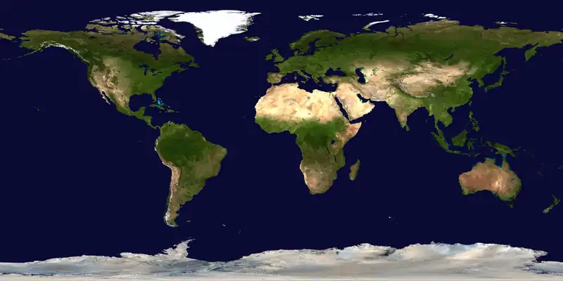


The world is the totality of entities, the whole of reality, or everything that exists. The nature of the world has been conceptualized differently in different fields. Some conceptions see the world as unique, while others talk of a "plurality of worlds". Some treat the world as one simple object, while others analyze the world as a complex made up of parts.
In scientific cosmology, the world or universe is commonly defined as "the totality of all space and time; all that is, has been, and will be". Theories of modality talk of possible worlds as complete and consistent ways how things could have been. Phenomenology, starting from the horizon of co-given objects present in the periphery of every experience, defines the world as the biggest horizon, or the "horizon of all horizons". In philosophy of mind, the world is contrasted with the mind as that which is represented by the mind.
Theology conceptualizes the world in relation to God, for example, as God's creation, as identical to God, or as the two being interdependent. In religions, there is a tendency to downgrade the material or sensory world in favor of a spiritual world to be sought through religious practice. A comprehensive representation of the world and our place in it, as is found in religions, is known as a worldview. Cosmogony is the field that studies the origin or creation of the world, while eschatology refers to the science or doctrine of the last things or of the end of the world.
In various contexts, the term "world" takes a more restricted meaning associated, for example, with the Earth and all life on it, with humanity as a whole, or with an international or intercontinental scope. In this sense, world history refers to the history of humanity as a whole, and world politics is the discipline of political science studying issues that transcend nations and continents. Other examples include terms such as "world religion", "world language", "world government", "world war", "world population", "world economy", or "world championship". (Full article...)
Selected articles -
 There are past and present public debates over certain aspects of climate change: how much has occurred in modern times, what causes it, what its effects will be, and what action should be taken to curb it now or later, and so forth. In the scientific literature, there is a very strong consensus that global surface temperatures have increased in recent decades and that the trend is caused by human-induced emissions of greenhouse gases.
The controversies are now primarily political rather than scientific, as there is a scientific consensus that global warming is occurring and is driven by human activities. Public debates that also reflect scientific debate include estimates of how responsive the climate system might be to any given level of greenhouse gases (climate sensitivity). Disputes over the key scientific facts of global warming are more prevalent in the media than in the scientific literature, where such issues are treated as resolved, and such disputes are more prevalent in the United States and Australia than globally. (Full article...)- The Internet (or internet) is the global system of interconnected computer networks that uses the Internet protocol suite (TCP/IP) to communicate between networks and devices. It is a network of networks that comprises private, public, academic, business, and government networks of local to global scope, linked by electronic, wireless, and optical networking technologies. The Internet carries a vast range of information services and resources, such as the interlinked hypertext documents and applications of the World Wide Web (WWW), electronic mail, discussion groups, internet telephony, streaming media and file sharing.
Most traditional communication media, including telephone, radio, television, paper mail, newspapers, and print publishing, have been transformed by the Internet, giving rise to new media such as email, online music, digital newspapers, news aggregators, and audio and video streaming websites. The Internet has enabled and accelerated new forms of personal interaction through instant messaging, Internet forums, and social networking services. Online shopping has also grown to occupy a significant market across industries, enabling firms to extend brick and mortar presences to serve larger markets. Business-to-business and financial services on the Internet affect supply chains across entire industries. (Full article...) - World Rugby is the governing body for the sport of rugby union. World Rugby organises the Rugby World Cup every four years, the sport's most recognised and most profitable competition. It also organises a number of other international competitions, such as the Nations Cup, the WXV Global Series, the Junior World Championship, the Pacific Nations Cup and the SVNS.
World Rugby's headquarters are in Dublin, Ireland. Its membership now comprises 133 national unions. Each member country must also be a member of one of the six regional unions into which the world is divided: Africa, North America, Asia, Europe, South America, and Oceania. (Full article...) - The fastest known time (FKT) for circumnavigation of the globe by bicycle is awarded for completing a continuous journey around the globe by bicycle and other means, consisting of a minimum 29,000 km (18,000 miles) in total distance cycled.
By convention, most FKT attempts follow the Guinness World Record (GWR) Rules. One can still have the FKT but not the GWR. For example, Lee Fancourt set an FKT which was not ratified due to him not strictly following the GWR Rules. (Full article...) - Around the World in 80 Days with Michael Palin is a 7-part BBC television travel series first broadcast on BBC1 from 11 October to 22 November 1989, and presented by comedian and actor Michael Palin. Inspired by Jules Verne's 1872 novel Around the World in Eighty Days, in which Phileas Fogg accepts a wager to circumnavigate the globe in eighty days or less, Palin takes on the same task, prohibited from using aircraft in order to use a combination of trains, boats and other forms of transport, to take him across several countries around his circumnavigation of the world, including Italy, India, Egypt, China, Japan, and the United States.
The programme was a critical and commercial success, gaining strong ratings in the UK and selling well abroad. It was also released on video tape and later on DVD. Following the trip Michael Palin wrote a book about the experience. The book contains much more detail, along with photographs, than could be presented in the TV programme, and Palin's personal views are also more evident. (Full article...) 
Early in the COVID-19 pandemic, convention centers (pictured here) were deemed to be ideal sites for temporary hospitals, due to their existing infrastructure (electrical, water, sewage). Hotels and dormitories were also considered appropriate because they can use negative pressure technology.
A pandemic (/pænˈdɛmɪk/ pan-DEM-ik) is an epidemic of an infectious disease that has a sudden increase in cases and spreads across a large region, for instance multiple continents or worldwide, affecting a substantial portion of the human population. Widespread endemic diseases with a stable number of infected individuals such as recurrences of seasonal influenza are generally excluded as they occur simultaneously in large regions of the globe rather than being spread worldwide.
Throughout human history, there have been a number of pandemics of diseases such as smallpox. The Black Death, caused by the Plague, caused the deaths of up to half of the population of Europe in the 14th century. The term pandemic had not been used then, but was used for later epidemics, including the 1918 H1N1 influenza A pandemic—more commonly known as the Spanish flu—which is the deadliest pandemic in history. The most recent pandemics include the HIV/AIDS pandemic, the 2009 swine flu pandemic and the COVID-19 pandemic. Almost all these diseases still circulate among humans though their impact now is often far less. (Full article...)
Cover of The Global Village: Transformations in World Life and Media in the 21st Century, published in 1989
Global village describes the phenomenon of the entire world becoming more interconnected as the result of the propagation of media technologies throughout the world. The term was coined by Canadian media theorist Marshall McLuhan in his books The Gutenberg Galaxy: The Making of Typographic Man (1962) and Understanding Media (1964), and the concept was expanded upon in The Global Village: Transformations in World Life and Media in the 21st Century (1989). Literary scholar Sue-Im Lee describes how the term global village has come to designate “the dominant term for expressing a global coexistence altered by transnational commerce, migration, and culture” (as cited in Poll, 2012). Economic journalist Thomas Friedman's definition of the global village as a world “tied together into a single globalized marketplace and village” is another contemporary understanding of the term (as cited in Poll, 2012). (Full article...)
General images -
 Lithified stromatolites on the shores of Lake Thetis, Western Australia. Archean stromatolites are the first direct fossil traces of life on Earth. (from History of Earth)
 Angkor Wat temple complex, Cambodia, early 12th century

 Pale orange dot, an impression of Early Earth, featuring its tinted orange methane-rich early atmosphere (from Earth)
 Great Pyramids of Giza, Egypt
 Last Moon landing: Apollo 17 (1972)
 Graph showing range of estimated partial pressure of atmospheric oxygen through geologic time (from History of Earth)
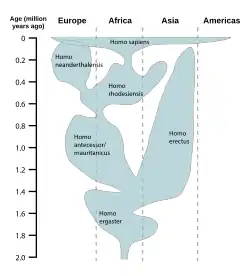 A reconstruction of human history based on fossil data. (from History of Earth)
 Image of the physical world, captured by the Hubble Space Telescope (from World)
 The Colosseum in Rome (from Human history)
 Cross-section through a liposome (from History of Earth)
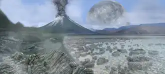 Artist's impression of Earth during the later Archean, the largely cooled planetary crust and water-rich barren surface, marked by volcanoes and continents, features already round microbialites. The Moon, still orbiting Earth much closer than today and still dominating Earth's sky, produced strong tides. (from History of Earth)
 A view of the Southern Pacific under moonlight with different layers of Earth's atmosphere visible: the troposphere with its clouds casting shadows, a band of stratospheric blue sky at the horizon, and a line of green airglow of the lower thermosphere around an altitude of 100 km, at the edge of space (from Earth)
 Satellite time-lapse imagery of Earth's rotation showing axis tilt (from Earth)
 Standing Buddha from Gandhara, 2nd century CE
 European migrations by mostly Germanic peoples, 2nd–6th centuries (from Human history)
 Artist's impression of the enormous collision that probably formed the Moon (from History of Earth)

 A reconstruction of Pannotia (550 Ma). (from History of Earth)


 COVID-19 pandemic, 2020 (from Human history)

 A depiction of the early Solar System's protoplanetary disk from which Earth and other Solar System bodies were formed (from Earth)
 A computer-generated image mapping the prevalence of artificial satellites and space debris around Earth in geosynchronous and low Earth orbit (from Earth)
 Japanese depiction of a Portuguese carrack, a result of globalizing maritime trade
 A map of heat flow from Earth's interior to the surface of Earth's crust, mostly along the oceanic ridges (from Earth)

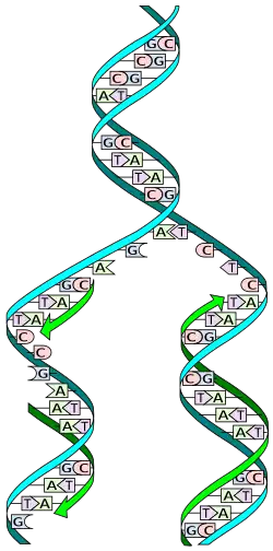 The replicator in virtually all known life is deoxyribonucleic acid. DNA is far more complex than the original replicator and its replication systems are highly elaborate. (from History of Earth)
 Ming dynasty section, Great Wall of China
 Artist's rendition of an oxinated fully-frozen Snowball Earth with no remaining liquid surface water. (from History of Earth)
 Pillar erected by Ashoka, a Mauryan Emperor in India
 An artist's impression of ice age Earth at glacial maximum. (from History of Earth)
 Artist's conception of Devonian flora (from History of Earth)
 Geologic map of North America, color-coded by age. From most recent to oldest, age is indicated by yellow, green, blue, and red. The reds and pinks indicate rock from the Archean.
 An animation of the changing density of productive vegetation on land (low in brown; heavy in dark green) and phytoplankton at the ocean surface (low in purple; high in yellow) (from Earth)
 A view of Earth with its global ocean and cloud cover, which dominate Earth's surface and hydrosphere; at Earth's polar regions, its hydrosphere forms larger areas of ice cover. (from Earth)
 A composite image of Earth with an opaque cloud cover, making the different types of surface discernible: Earth's surface dominating Ocean (blue), Africa with lush (green) to dry (brown) land and Earth's polar ice in the form of Antarctic sea ice (grey) covering the Antarctic or Southern Ocean and the Antarctic ice sheet (white) covering Antarctica. (from Earth)
 Yggdrasil, an attempt to reconstruct the Norse world tree which connects the heavens, the world, and the underworld. (from World)

 Machu Picchu, Inca Empire, Peru
 Chloroplasts in the cells of a moss (from History of Earth)
 Vitruvian Man, c. 1490 by Leonardo da Vinci, epitomizes the advances in art and science seen during the Renaissance. (from History of Earth)
- The pale orange dot, an artist's impression of the early Earth which might have appeared orange through its hazy methane rich prebiotic second atmosphere. Earth's atmosphere at this stage was somewhat comparable to today's atmosphere of Titan. (from History of Earth)
 Earth depicted to scale alongside the planetary-mass objects of the Inner Solar System. From left: Mercury, Venus, Earth, the Moon, Mars and Ceres. (from Earth)
 A banded iron formation from the 3.15 Ga Moodies Group, Barberton Greenstone Belt, South Africa. Red layers represent the times when oxygen was available; gray layers were formed in anoxic circumstances. (from History of Earth)
 Artist's conception of Hadean Eon Earth, when it was much hotter and inhospitable to all forms of life. (from History of Earth)
 Earth's history with time-spans of the eons to scale. Ma means "million years ago", Ga means "billion years ago". (from History of Earth)
 One of the eleven Rock-hewn Churches of Lalibela constructed during the Zagwe dynasty in Ethiopia (from Human history)

Megacities of the world -

Tianjin, previously romanized as Tienchin or Tientsin, is a provincial-level direct-administered municipality in China. It is located on the shore of the Bohai Sea. It has a total population of 13,866,009 inhabitants at the 2020 census.
Tianjin borders Hebei Province and Beijing Municipality, bounded to the east by the Bohai Gulf portion of the Yellow Sea. Part of the Bohai Economic Rim, it is the largest coastal city in Northern China and part of the Jing-Jin-Ji megapolis. (Full article...)
Did you know -

- ... that Classic Tetris World Champion Alex Thach celebrates victories by dumping Parmesan cheese on his head?
- ... that Panamanian earth scientist Erika Podest uses remote sensing to see how climate change has affected global soil moisture?
- ... that the satellite TRUTHS is planned to enable the precise calibration of Earth observation data from other satellites?
- ... that the excavator of the Palazzo delle Colonne had to publish his findings from photographs and memory after World War II interrupted the excavation and vandals destroyed the records?
- ... that the Wangdue Phodrang Dzong was destroyed by a fire in 1837, damaged by an earthquake in 1897 and destroyed again by a fire in 2012?
- ... that the deity of the Phoenician sanctuary of Kharayeb remains unidentified due to the absence of names of specific gods in unearthed inscriptions?
- ... that many North Carolina Farmers' Union members left the organization as a result of leader Henry Quincy Alexander's opposition to American entry into World War I?
- ... that the sarcophagus of Eshmunazar II, the Phoenician king of Sidon, is one of only three ancient Egyptian sarcophagi unearthed outside Egypt?
Countries of the world -

Uruguay, officially the Oriental Republic of Uruguay, is a country in the Southern Cone of southeastern South America. It shares borders with Argentina to its west and southwest and Brazil to its north and northeast, while bordering the Río de la Plata to the south and the Atlantic Ocean to the southeast. Uruguay covers an area of approximately 176,215 square kilometers (68,037 sq mi). It has a population of almost 3.5 million people, of whom nearly 2 million live in the metropolitan area of its capital and largest city, Montevideo.
The area that became Uruguay was first inhabited by groups of hunter gatherers 13,000 years ago. The first European explorer to reach the region was Juan Díaz de Solís in 1516, but the area was colonized later than its neighbors. At the time of European arrival, the Charrúa were the predominant tribe, alongside other groups such as the Guaraní and the Chaná. However, none of these peoples were socially or politically organized in large groups, which contributed to their decline. Amid territorial disputes, the Portuguese established Colônia do Sacramento in 1680, and the Spanish founded Montevideo as a military stronghold. Uruguay secured its independence between 1811 and 1828, following a four-way struggle involving Portugal, Spain, and later the United Provinces of the Río de la Plata and the Empire of Brazil. In 1830, the country enacted its constitution and was formally established as an independent state. (Full article...)

The New 7 Wonders of the World was a campaign started in 2001 to choose Wonders of the World from a selection of 200 existing monuments. The popularity poll via free web-based voting and telephone voting was led by Canadian-Swiss Bernard Weber and organized by the New 7 Wonders Foundation (N7W) based in Zurich, Switzerland, with winners announced on 7 July 2007 at Estádio da Luz in Lisbon. The poll was considered unscientific partly because participants were allowed to vote repeatedly. According to John Zogby, founder and current President/CEO of the US polling organization Zogby International, New 7 Wonders Foundation drove "the largest poll on record".
The program drew a wide range of official reactions. Some countries touted their finalist and tried to get more votes cast for it, while others downplayed or criticized the contest. After supporting the New 7 Wonders Foundation at the beginning of the campaign by providing advice on nominee selection, the United Nations Educational, Scientific, and Cultural Organization (UNESCO), bound by its bylaws to record and give equal status to all World Heritage Sites, distanced itself from the undertaking in 2001 and again in 2007. (Full article...)
Related portals
Protected areas of the world -
- This is a list of protected areas in Bulgaria which includes 3 national parks, 11 nature parks and 55 nature reserves. The national policy for governing and management of the protected areas is implemented by the Ministry of Environment and Water. The first nature park in Bulgaria and the Balkan Peninsula is Vitosha Nature Park, established in 1934. All of the nationally protected areas in Bulgaria are also part of the Natura 2000 network of protected natural areas in the territory of the European Union. Bulgaria has some of the largest Natura 2000 areas in the European Union covering 33.8% of its territory.
- Parks and reserves in italic letters are part of Global 200 ecoregions.
- This is a list of protected areas of Sierra Leone, including national parks, game reserves, conservation areas, wetlands, and those that are listed as proposed protected areas in the UN Environment Programme World Conservation Monitoring Centre (UNEP WCM) database. (Full article...)

A Bengal Tiger in Bardiya National Park
The protected areas of Nepal cover mainly forested land and are located at various altitudes in the Terai, in the foothills of the Himalayas and in the mountains, thus encompassing a multitude of landscapes and preserving a vast biodiversity in the Palearctic and Indomalayan realms.
Nepal covers 147,181 km2 (56,827 sq mi) in the central part of the Himalayas. Altitudes range from 67 m (220 ft) in the south-eastern Terai to 8,848 m (29,029 ft) at Mount Everest within a short horizontal span. This extreme altitudinal gradient has resulted in 11 bio-climatic zones ranging from lower tropical below 500 m (1,600 ft) to nival above 5,000 m (16,000 ft) in the High Himalayas, encompassing nine terrestrial ecoregions with 36 vegetation types.
Additionally, nine Ramsar sites were declared between 1988 and 2008. Two wildlife reserves were declared as national parks in 2017. (Full article...)
Upolu Island, Samoa
This is a list of some protected areas of Samoa which include national parks, reserves, community conservation areas, marine protected areas and fish reserves and other areas of significant biodiversity and conservation.
In 1994, Samoa ratified the international and legally binding treaty, the Convention on Biological Diversity to develop national strategies for conservation and sustainable use of biological diversity. In 2010, protected areas in the country cover 5% of land although the government aims to increase protected areas coverage to 15%. (Full article...)- A list of protected areas of Oman:
- Al Jabal Algharbi Nature Reserve
- Aldhahra Nature Reserve
- Alburaimi Oasis Nature Reserve
- Oryx Nature Reserve
- Turtle Reserve
- Ad Dimaniyat Islands Reserve
- Al Saleel National Park (As Salil Natural Park)
- Jabal Samhan Nature Reserve
- Al Jabal Al Akhdar Scenic Reserve
- Western Hajer Stars Lights Reserve
- Al Rustaq Wildlife Reserve
- Al Wusta Wetland Reserve
- Jabal Qahwan Nature Reserve
- Al Sareen Nature Reserve
- Ras al Shajar Nature Reserve
- Al Khuwuair Nature Reserve
- Khawrs of the Dhofar Coast Reserve
- Khor Slalalah Nature Reserve
- Khawr al Mughsayl Reserve
- Khawr al Baleed Reserve
- Khawr Sawli Reserve
- Khawr al Dahareez Reserve
- Khawr Taqah Reserve
- Khawr Rawri Reserve
- Khawr Awqad Reserve
- Khawr al Qurum al Sagheer Reserve
- Khawr al Qurum al Kabeer Reserve
- The protected areas of Michigan come in an array of different types and levels of protection. Michigan has five units of the National Park Service system. There are 14 federal wilderness areas; the majority of these are also tribal-designated wildernesses. It has one of the largest state forest systems as well having four national forests. The state maintains a large state park system and there are also regional parks, and county, township and city parks. Still other parks on land and in the Great Lakes are maintained by other governmental bodies. Private protected areas also exist in the state, mainly lands owned by land conservancies. (Full article...)

Flamingos at the Ras Al Khor Wildlife Sanctuary
This is a list of protected areas of United Arab Emirates:- Abu Dhabi Mangrove and Coastal Wetland Reserve
- Ain al Faydah National Park
- Al Awir Nature Reserve
- Al Khawanij Nature Reserve
- Al Maha Nature Reserve
- Al Marmoom Desert Conservation Reserve
- Al Wohoosh Desert Conservation Reserve
- Dubai Desert Conservation Reserve National Park
- Hatta Nature Reserve
- Jabal Ali Wildlife Sanctuary
- Khor Kalba Nature Reserve
- Marawah Marine Protected Area
- Mushrif National Park
- Nadd Al Sheba Nature Reserve
- Rams Lagoon Reserve
- Ras Al Khor Wildlife Sanctuary
- Wadi Wurayah National Park
- Zirkuh Island Bird Sanctuary

The mountain of Stob Binnein lies in the Loch Lomond and The Trossachs National Park.
Many parts of Scotland are protected in accordance with a number of national and international designations because of their environmental, historical or cultural value. Protected areas can be divided according to the type of resource which each seeks to protect. NatureScot has various roles in the delivery of many environmental designations in Scotland, i.e. those aimed at protecting flora and fauna, scenic qualities and geological features. Historic Environment Scotland is responsible for designations that protect sites of historic and cultural importance. Some international designations, such as World Heritage Sites, can cover both categories of site.
The various designations overlap considerably with many protected areas being covered by multiple designations with different boundaries. (Full article...)
Bonampak is an ancient Maya archaeological site in the Mexican state of Chiapas, and is a natural monument.
There are currently 232 Protected Natural Areas in Mexico, covering 98 million hectares in total. They are protected and administered by the National Commission of Protected Natural Areas (Comisión Nacional de Áreas Naturales Protegidas, or 'CONANP'), a federal agency under the Secretariat of Environment and Natural Resources (SEMARNAT). CONANP administers:- 79 Mexican National Parks
- 48 biosphere reserves
- 57 flora and fauna protection areas
- 28 Mexican Nature Sanctuaries
- 15 natural resources protection areas
- 5 natural monuments
- Protected areas of West Bengal cover 4% of the state area. Forests make up 14% of the geographical area of West Bengal, which is lower than the national average of 33%. West Bengal has a wide variety of fauna, including Bengal tigers, Indian leopards, sloth and Himalayan black bears, chital and sambar (deer), Indian boars, pygmy hogs, Indian elephants, Indian peafowl, great Indian hornbills, Eurasian spoonbills, brahminy ducks, king and Indian cobras, white-lipped pit viper, Indian and reticulated pythons, mugger crocodiles, saltwater crocodiles, gharials, and many more. A huge montane forest, Dooars, is situated in the Northern West Bengal districts of Alipur Duar, Darjeeling, and Kalimpong. Part of the world's largest mangrove forest, Sundarbans, is located in southern West Bengal.
There are 6 national parks and 15 wildlife sanctuaries in West Bengal. (Full article...) 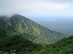
Mombacho Volcano Natural Reserve
The protected areas of Nicaragua are areas that have natural beauty or significance and are protected by Nicaragua. Nicaragua has 78 protected areas that cover 22,422 km2, about 17.3% of the nations landmass. The National System of Protected Areas (SINAP) is administered by the Ministry of the Environment and Natural Resources (MARENA). (Full article...)- Papua New Guinea is home to several protected areas, which receive protection because of their environmental, cultural or similar value.
The total area of Papua New Guinea protected territories is 14,330 km2 (5,530 sq mi), which amounts to approximately 3.07% of the country's territory. The total number of protected areas as 2018 is 71. (Full article...) - The Protected areas of New South Wales include both terrestrial and marine protected areas. As of June 2020 there are 225 national parks in New South Wales. A number established since the late 1970s followed campaigns by local residents and environmentalists.
Based on the Collaborative Australian Protected Area Database (CAPAD) 2020 data there are 2136 separate terrestrial protected areas with a total land area of 7,696,641 hectares (19,018,810 acres) (9.61% of the state's area). CAPAD data also shows 18 marine protected areas with a total area of 348,849 hectares (862,020 acres), covering 39.63% of NSW waters. (Full article...) 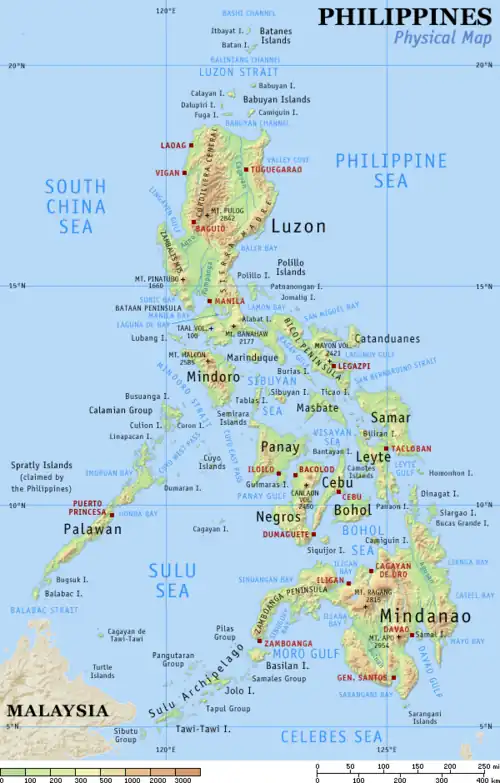
In the Philippines, protected areas are administered by the Biodiversity Management Bureau of the Department of Environment and Natural Resources (DENR) under the National Integrated Protected Areas System (NIPAS) Act of 1992.
As of 2020, there are 244 protected areas in the Philippines, covering a total area of about 7,760,000 hectares (19,200,000 acres) – 15.4% of the Philippines' total area. (Full article...)
Vegetation outside Goz Beïda
The wildlife of Chad is composed of its flora and fauna. West African lions, African buffalo, hippopotamuses, Kordofan giraffes, antelopes, African leopards, cheetahs, hyenas, bush elephants, and many species of snakes are found there, although most large carnivore populations have been drastically reduced since the early 20th century. Elephant poaching, particularly in the south of the country in areas such as Zakouma National Park, is a severe problem. (Full article...)
Selected world maps
 The world map by Gerardus Mercator (1569), the first map in the well-known Mercator projection
 The Goode homolosine projection is a pseudocylindrical, equal-area, composite map projection used for world maps.
 1516 map of the world by Martin Waldseemüller
 Index map from the International Map of the World (1:1,000,000 scale)
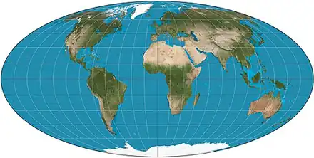 Mollweide projection of the world
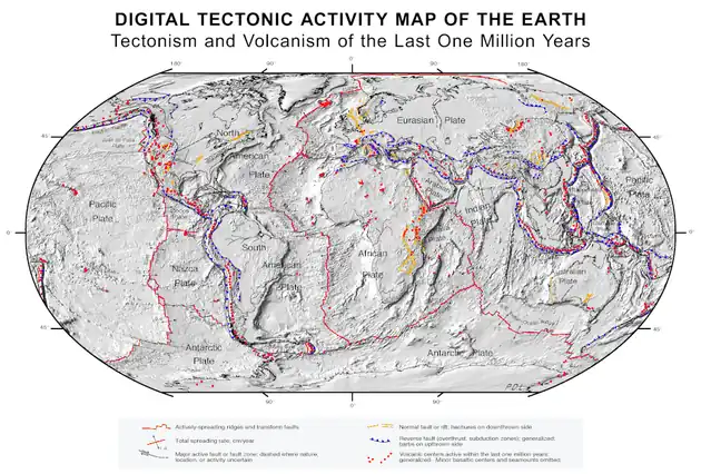 A plate tectonics map with volcano locations indicated with red circles
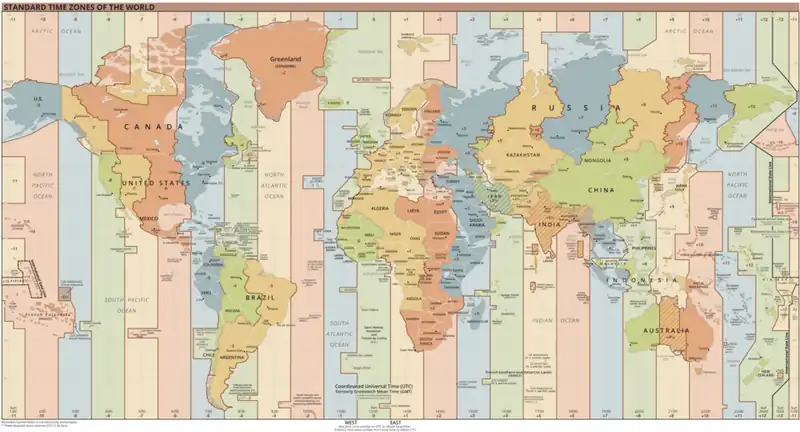 Time zones of the world
 Only a few of the largest large igneous provinces appear (coloured dark purple) on this geological map, which depicts crustal geologic provinces as seen in seismic refraction data
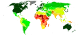 United Nations Human Development Index map by country (2016)
World records
- List of Olympic records in athletics
- List of world records in athletics
- List of junior world records in athletics
- List of world records in masters athletics
- List of world youth bests in athletics
- List of IPC world records in athletics
- List of world records in canoeing
- List of world records in chess
- List of cycling records
- List of world records in track cycling
- List of world records in finswimming
- List of world records in juggling
- List of world records in rowing
- List of world records in speed skating
- List of world records in swimming
- List of IPC world records in swimming
- List of world records in Olympic weightlifting
Topics

Continents of Earth | ||||||||
|---|---|---|---|---|---|---|---|---|
| ||||||||
| ||||||||
| ||||||||


| Cenozoic Era (present–66.0 Ma) |
|  | |||||||||||
|---|---|---|---|---|---|---|---|---|---|---|---|---|---|
| Mesozoic Era (66.0–252 Ma) |
| ||||||||||||
| Paleozoic Era (252–539 Ma) |
| ||||||||||||
| Proterozoic Eon (539 Ma–2.5 Ga) |
| ||||||||||||
| Archean Eon (2.5–4 Ga) | |||||||||||||
| Hadean Eon (4–4.6 Ga) | |||||||||||||
ka = kiloannum (thousand years ago); Ma = megaannum (million years ago); Ga = gigaannum (billion years ago). See also: Geologic time scale •  Geology portal •  World portal | |||||||||||||
| Locations |  | |
|---|---|---|
| Related | ||


| |||||||||||||||||||
| |||||||||||||||||||
| |||||||||||||||||||


Economic classification of countries | |||||
|---|---|---|---|---|---|
| Three-World Model | |||||
| Gross domestic product (GDP) |
| ||||
| Gross national income (GNI) | |||||
| Wages | |||||
| Wealth | |||||
| Other national accounts | |||||
| Human development | |||||
| Digital divide | |||||
| Net international investment position (NIIP) | |||||

| Technological |
| ||||
|---|---|---|---|---|---|
| Sociological | |||||
| Ecological |
| ||||
| Biological |
| ||||
| Astronomical | |||||
| Eschatological |
| ||||
| Others |
| ||||
| Fictional | |||||
| Organizations | |||||
Categories

Wikimedia
The following Wikimedia Foundation sister projects provide more on this subject:
-
 Commons
Free media repository -
 Wikidata
Free knowledge base -
 Wikiquote
Collection of quotations -
 Wikisource
Free-content library -
 Wikispecies
Directory of species -
 Wikiversity
Free learning tools -
 Wikivoyage
Free travel guide -
 Wiktionary
Dictionary and thesaurus
More portals
-
 List of all portals
-

-

-

-
-

-

-

-

-

-
 Random portal
-
 WikiProject Portals