This portal is manually maintainedbyNorthamerica1000.Please contact these user(s)when you plan to make significant changes.
This portal's subpages have been checked by an editor, and are needed.
Please take care when editing, especially if using automated editing software, and seek consensus before making major changes.Learn how to update the maintenance information here.
The Northwest Coast is the coastal region of the Pacific Northwest, and the Northwest Plateau (known simply as "the Interior" in British Columbia), is the inland region. The term "Pacific Northwest" should not be confused with the Northwest Territory (also known as the Great Northwest, a historical term in the United States) or the Northwest Territories of Canada.
The culture of the Pacific Northwest is influenced by the Canada–United States border, which had been established at a time when the region's inhabitants were composed mostly of indigenous peoples. Two sections of the border—one along the 49th parallel south of British Columbia and one between the Alaska Panhandle and northern British Columbia—have left a great impact on the region. According to Canadian historian Ken Coates, the border has not merely influenced the Pacific Northwest—rather, "the region's history and character have been determined by the boundary". (Full article...)
Selected article -
Eastern Oregon population according to the eight-county definition
Eastern Oregon is a region of the U.S. state of Oregon. It is not an officially recognized geographic entity; thus, the boundaries of the region vary according to context. It is sometimes understood to include only the eight easternmost counties in the state; in other contexts, it includes the entire area east of the Cascade Range. Cities in the basic eight-county definition include Baker City, Burns, Hermiston, Pendleton, Boardman, John Day, La Grande, and Ontario. Umatilla County is home to the largest population base in Eastern Oregon, accounting for 42% of the region's residents — more than twice that of the region’s second most populous, Malheur County. Hermiston, located in Umatilla County, is the largest city in the region, accounting for 10% of the population. Major industries include transportation/warehousing, timber, agriculture and tourism. The main transportation corridors are I-84, U.S. Route 395, U.S. Route 97, U.S. Route 26, U.S. Route 30, and U.S. Route 20.
Kenneth Callahan (1905–1986) was an American painter and muralist who served as a catalyst for Northwest artists in the mid-20th century through his own painting, his work as assistant director and curator at the Seattle Art Museum, and his writings about contemporary art. Born in Eastern Washington and largely self-taught as an artist, Callahan was committed to an art that went beyond the merely illustrative. He enrolled at the University of Washington in 1924 but did not stay long. He traveled widely, absorbing influences from the different countries and cultures he experienced. His talent was recognized early; his work was included in the first Whitney Biennial exhibition in 1933 and he went on to a distinguished painting career. Callahan is identified as one of the Northwest Mystics – along with Guy Anderson, Morris Graves, and Mark Tobey, who shared a muted palette and strong interest in Asian aesthetics. (Full article...)
Image 10The Coast Mountains are heavily eroded by glaciers, including Mount Waddington (far background, center). (from Geology of the Pacific Northwest)
Image 11Geology of the Cascade Range-related plate tectonics. (from Cascade Range)
Image 12Lumen Field, home of Seattle Seahawks and Sounders FC (from Pacific Northwest)
Image 17Pacific Northwest Trail at Blanchard Mountain in Washington (from Pacific Northwest Trail)
Image 18The Seawall around Stanley Park in Vancouver is the longest uninterrupted waterfront pathway in the world, and includes a popular bike route. (from Pacific Northwest)
Image 25Magnetic anomalies around the Juan de Fuca and Gorda Ridges, off the west coast of North America, color coded by age. (from Geology of the Pacific Northwest)
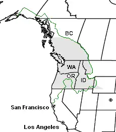
Image 29None of the multiple possible definitions of the Pacific Northwest are universally accepted. This map shows three possibilities: (1) The shaded area shows the historical Oregon Country. (2) The green line shows the Cascadia bioregion. (3) The labeled states and provinces include Washington, Idaho, Oregon and British Columbia. (from Pacific Northwest)
Image 30Vancouver's SkyTrain rapid transit system achieves daily ridership of over 500,000 passengers per day on weekdays and the overall transit ridership levels in the Metro Vancouver area rank third in North America per capita. (from Pacific Northwest)
Image 34Map of most of the Cascadia urban megaregion, showing population density (shades of yellow/brown), highways (red), and major railways (black). Public land shown in shades of green. This map omits the southern Willamette Valley, which is typically considered part of the megaregion. (from Pacific Northwest)
... that Warren Truitt served as a legislator in Oregon and a judge in Alaska in the 19th century, and as both a legislator and a judge in Idaho in the 20th?