Windom, Minneapolis
Windom | |
|---|---|
 Lake Mead | |
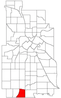 Location of Windom within the U.S. city of Minneapolis | |
Interactive map of Windom | |
| Country | United States |
| State | Minnesota |
| County | Hennepin |
| City | Minneapolis |
| Community | Southwest |
| Founded | 1849 |
| City Council Ward | 11 |
| Government | |
| • Council Member | Jamison Whiting |
| Area | |
• Total | 0.749 sq mi (1.94 km2) |
| Population (2020)[2] | |
• Total | 5,386 |
| • Density | 7,190/sq mi (2,780/km2) |
| Time zone | UTC-6 (CST) |
| • Summer (DST) | UTC-5 (CDT) |
| ZIP code | 55419 |
| Area code | 612 |
| Census | Pop. | Note | %± |
|---|---|---|---|
| 1980 | 5,061 | — | |
| 1990 | 5,188 | 2.5% | |
| 2000 | 4,984 | −3.9% | |
| 2010 | 4,980 | −0.1% | |
| 2020 | 5,386 | 8.2% |
The Windom neighborhood is located in the Southwest community of Minneapolis. Its borders are Diamond Lake Road and West 54th Street to the north, Interstate 35W to the east, West 62nd Street (Highway 62) to the south, and Lyndale Avenue South and Highway 121 to the west. Windom is a part of ward 11 of the Minneapolis City Council[3] and state legislative district 63B.[4]
On August 27, 2025, Windom was the site of a mass shooting targeting the Annunciation Catholic Church. Two schoolchildren were killed and there were multiple injuries.[5][6] The FBI is investigating the shooting as an anti-Catholic hate crime and as an act of domestic terrorism.[7]
Demographics
| Race/ethnicity | ||||||
|---|---|---|---|---|---|---|
| 2000[10] | 2010[10] | 2020[10] | ||||
| Number | % | Number | % | Number | % | |
| White alone | 3,492 | 70.06 | 3,036 | 60.96 | 3,023 | 58.48 |
| Black alone | 299 | 6.00 | 508 | 10.20 | 658 | 12.73 |
| Hispanic or Latino (any race) | 155 | 3.11 | 176 | 3.53 | 494 | 9.56 |
| Native American alone | 41 | 0.82 | 61 | 1.22 | 24 | 0.46 |
| Asian alone | 126 | 2.53 | 130 | 2.61 | 143 | 2.77 |
| Other race alone | 8 | 0.16 | 17 | 0.34 | 11 | 0.21 |
| Pacific Islander alone | 4 | 0.08 | 6 | 0.12 | 0 | 0.00 |
| Two or more races | 181 | 3.63 | 210 | 4.22 | 317 | 6.13 |
| Total | 4,984 | 100.0 | 4,980 | 100.0 | 5,169 | 100.0 |
References
- ↑ "Windom neighborhood in Minneapolis, Minnesota (MN), 55419 detailed profile". City-Data. 2011. Retrieved 2013-11-19.
- ↑ "Windom neighborhood data". Minnesota Compass. Retrieved 2023-02-19.
- ↑ "Find My Ward". City of Minneapolis. Retrieved 19 April 2024.
- ↑ "Metro Area Legislative Districts" (PDF). Minnesota Secretary of State. Retrieved 16 May 2025.
- ↑ Vancleave, Mark (August 27, 2025). "This was the first week back to class for Annunciation School". Associated Press. Retrieved August 27, 2025.
- ↑ Nace, Aki (August 27, 2025). "2 dead, up to 20 victims in Minneapolis shooting at Annunciation Catholic School; shooter dead - CBS Minnesota". CBS News. Retrieved August 27, 2025.
- ↑ Winter, Tom (2025-08-27). "Shooting to be investigated as domestic terrorism and hate crime, FBI director says". NBC News. Retrieved 2025-08-27.
- ↑ Windom, Minneapolis, MN. Google Earth. Retrieved 2011-03-09.
- ↑ Windom, Minneapolis, MN. Google Earth. Retrieved 2011-03-09.
- 1 2 3 "2000 - 2020 Minneapolis demographic changes by neighborhood dashboard". www.minneapolismn.gov. Retrieved 2024-06-13.
Businesses
External links
- Minneapolis Neighborhood Profile - Windom
- Windom neighborhood website
- Nicollet-East Harriet Business Association(NEHBA)
- Experience Southwest : Southwest Minneapolis Business Directory (NEHBA sponsored)
Places adjacent to Windom, Minneapolis | ||||||||||||||||
|---|---|---|---|---|---|---|---|---|---|---|---|---|---|---|---|---|
| ||||||||||||||||


