Timbaúba
Timbauba | |
|---|---|
 Flag | |
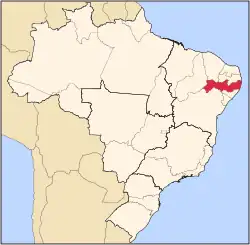
  Timbauba Location within Brazil | |
| Coordinates: 7°30′39″S 35°19′04″W / 7.51083°S 35.31778°W | |
| Country |  Brazil |
| Regions | Northeast |
| State | Pernambuco |
| Founded | 1879 |
| Area | |
| 292.28 km2 (112.85 sq mi) | |
| Elevation | 102 m (335 ft) |
| Population | |
| 46,147 | |
| 47,312 | |
| • Density | 157.89/km2 (408.92/sq mi) |
| • Metro | 55,213 |
| Time zone | UTC−3 (BRT) |
| Postal code | 55870 |
| Area code | (+55) 81 |
Timbaúba (Central northeastern portuguese pronunciation: [tĩbɐˈubɐ]) is a city in Pernambuco, Brazil. According to the Brazilian Institute of Geography and Statistics, it has an estimated population of 47,312 inhabitants as of 2025.[1]
Geography
- State - Pernambuco
- Region - Zona da mata Pernambucana
- Boundaries - Paraíba state (N); Vicência (S); Macaparana (W); Aliança, Ferreiros and Camutanga (E)
- Area - 289.51 km2
- Elevation - 102 m
- Hydrography - Goiana River
- Vegetation - Subcaducifólia forest
- Climate - Hot tropical and humid
- Annual average temperature - 24.6 c
- Distance to Recife - 96 km
Economy
The main economic activities in Timbaúba are based in commerce and agribusiness, especially growing sugarcane and bananas, and raising livestock such as cattle, sheep and goats.
Economic indicators
| Population[2] | GDP x(1000 R$).[3] | GDP pc (R$) | PE |
|---|---|---|---|
| 51.770 | 304.452 | 5.908 | 0.50% |
Economy by sector 2006
| Primary sector | Secondary sector | Service sector |
|---|---|---|
| 12.06% | 19.05% | 68.89% |
Health indicators
| HDI (2000) | Hospitals (2007) | Hospitals beds (2007) | Children's mortality every 1000 (2005) |
|---|---|---|---|
| 0.649 | 2 | 153 | 25.2 |
Sports
The main sport in Timbaúba is football, which is represented by Timbaúba Futebol Clube, currently playing the Campeonato Pernambucano's Série A2.
See also
References
- 1 2 3 Brazilian Institute of Geography and Statistics (IBGE). "IBGE 2025".
- ↑ http://www.ibge.gov.br/home/estatistica/populacao/estimativa2009/POP2009_DOU.pdf IBGE Population 2009 Timbaúba, page 35]
- ↑ Timbaúba 2007 GDP IBGE page 32 Archived 2016-03-04 at the Wayback Machine
- ↑ PE State site - City by city profile
Capital: Recife | ||||||||||||||
| Mesoregion Agreste Pernambucano |
|  | ||||||||||||
| Mesoregion Mata Pernambucana |
| |||||||||||||
| Mesoregion Metropolitana de Recife |
| |||||||||||||
| Mesoregion Sao Francisco Pernambucano |
| |||||||||||||
| Mesoregion Sertão Pernambucano |
| |||||||||||||
