Sandvinvatnet
| Sandvinvatnet | |
|---|---|
| Sandvevatnet[1] | |
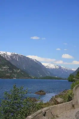 View of the lake | |
Interactive map of Sandvinvatnet | |
| Location | Ullensvang Municipality, Vestland |
| Coordinates | 60°02′30″N 6°32′28″E / 60.0416°N 6.5411°E |
| Storelvi river | |
| Opo river | |
| Basin countries | Norway |
| Max. length | 4.8 kilometres (3.0 mi) |
| Max. width | 1.5 kilometres (0.93 mi) |
Surface area | 4.36 km2 (1.68 sq mi) |
| Max. depth | 120 metres (390 ft) |
Shore length1 | 11.9 kilometres (7.4 mi) |
Surface elevation | 88 metres (289 ft) |
| Settlements | Odda |
| References | NVE[2] |
| 1 Shore length is not a well-defined measure. | |
Sandvinvatnet[1] is a lake in Ullensvang Municipality in Vestland county, Norway. The 4.3-square-kilometre (1.7 sq mi) lake lies on the southern edge of the town of Odda. The Buardalen valley and Buarbreen glacier lie to the west of the lake. The Norwegian National Road 13 runs along the east side of the lake. The lake water flows north into the short river Opo, before entering the Sørfjorden.[3]
See also
References
- 1 2 "Informasjon om stadnamn". Norgeskart (in Norwegian). Kartverket. Retrieved 2026-01-17.
- ↑ "Innsjødatabase". nve.no (in Norwegian). Retrieved 2026-01-17.
- ↑ Thorsnæs, Geir, ed. (2024-11-26). "Opo". Store norske leksikon (in Norwegian). Foreningen Store norske leksikon. Retrieved 2026-01-17.
Categories: