Andfiskvatnet
| Andfiskvatnet | |
|---|---|
 | |
Interactive map of Andfiskvatnet | |
| Location | Rana Municipality, Nordland |
| Coordinates | 66°16′20″N 14°07′49″E / 66.2721°N 14.1303°E / 66.2721; 14.1303 |
| Andfiskåga | |
| Basin countries | Norway |
| Max. length | 6 kilometres (3.7 mi) |
| Max. width | 0.8 kilometres (0.50 mi) |
Surface area | 2.7 km2 (1.0 sq mi) |
Shore length1 | 17.24 kilometres (10.71 mi) |
Surface elevation | 241 metres (791 ft) |
| References | NVE[1] |
| 1 Shore length is not a well-defined measure. | |
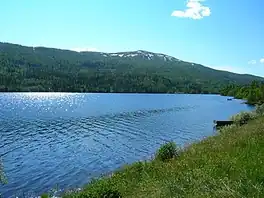
Andfiskvatnet[2] is a lake in Rana Municipality in Nordland county, Norway. The 2.7-square-kilometre (1.0 sq mi) lake lies about 3 kilometres (1.9 mi) southeast of the village of Hauknes and about 6 kilometres (3.7 mi) south of the town of Mo i Rana. The lake flows out into the river Andfiskåga which flows into the Ranfjorden.[3]
See also
References
- ↑ "Innsjødatabase". NVE.no (in Norwegian). Retrieved 2024-09-07.
- ↑ "Informasjon om stadnamn". Norgeskart (in Norwegian). Kartverket. Retrieved 2024-09-26.
- ↑ Store norske leksikon. "Andfiskåga" (in Norwegian). Retrieved 2011-12-15.
External links
 Media related to Andfiskvatnet at Wikimedia Commons
Hidden categories:
- Articles with short description
- Short description matches Wikidata
- Pages using gadget WikiMiniAtlas
- CS1 Norwegian-language sources (no)
- Coordinates on Wikidata
- Articles using infobox body of water without pushpin map
- Articles using infobox body of water without image bathymetry
- Articles using infobox body of water with mapframe
- Commons category link is on Wikidata
- All stub articles
- Pages using the Kartographer extension
This page is issued from Wikipedia. The text is available under Creative Commons Attribution-Share Alike 4.0 unless otherwise noted. Additional terms may apply for the media files.