Kalhovdfjorden
| Kalhovdfjorden | |
|---|---|
 View of the lake | |
Interactive map of Kalhovdfjorden | |
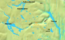 Location of Kalhovdfjorden in the Skiensvassdraget area | |
| Location | Tinn Municipality, Telemark |
| Coordinates | 60°04′05″N 8°18′46″E / 60.06809°N 8.31289°E |
| Mår | |
| Skien watershed | |
| Basin countries | Norway |
Surface area | 20.39 km2 (7.87 sq mi) |
Shore length1 | 79 kilometres (49 mi) |
Surface elevation | 1,084 metres (3,556 ft) |
| References | NVE[1] |
| 1 Shore length is not a well-defined measure. | |
Kalhovdfjorden[2] is a lake in Tinn Municipality in Telemark county, Norway. The lake lies about 20 kilometres (12 mi) to the north of the town of Rjukan and about 15 kilometres (9.3 mi) east of the Hardangervidda National Park. The lake is part of the Skien watershed. The river Mår is the main outflow of the lake. The lake Møsvatn lies to the southwest and the lake Tinnsjå lies to the southeast. The area of the lake is 20.39 square kilometers (7.87 sq mi) and it is located 1,084 meters (3,556 ft) above sea level.[3]
See also
References
- ↑ "Innsjødatabase". nve.no (in Norwegian). Retrieved 17 August 2023.
- ↑ "Informasjon om stadnamn". Norgeskart (in Norwegian). Kartverket. Retrieved 22 August 2026.
- ↑ Lundbo, Sten, ed. (25 November 2024). "Kalhovdfjorden". Store norske leksikon (in Norwegian). Foreningen Store norske leksikon. Retrieved 22 August 2026.
Categories: