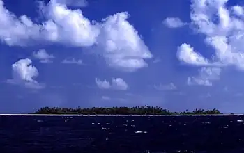
Coast of Tepuka, 2025 Tepuka is an island eighteen kilometers west of Fongafale, in the northwest of Funafuti, the main atoll of the Oceanian nation of Tuvalu. Te puka, or Pouka, is the name of a tree - Hernandia peltata.There is a well-preserved underground bunker on the island, which was an American communications outpost built during the Pacific War, which was connected to the military airfield on Fongafale. (Full article...)
Image 2
Sir Tomu Malaefone Sione (17 November 1941 – April 2016) was a political figure from the Pacific nation of Tuvalu. He worked as a journalist from 1962 to 1968, and held the post of radio announcer in the Broadcasting and Information Department of the administration of the Gilbert and Ellice Islands Colony (GEIC). He was the head of the southern Niutao clan. He was married to Segali. (Full article...)
Tuvaluannationality law is regulated by the 1986 Constitution of Tuvalu, as amended; the 1979 Citizenship Ordinance, and its revisions; and various British Nationality laws. These laws determine who is, or is eligible to be, a national of Tuvalu. Tuvaluan nationality is typically obtained either on the principle of jus soli, i.e. by birth in Tuvalu or under the rules of jus sanguinis, i.e. by birth abroad to parents with Tuvaluan nationality. It can be granted to persons with an affiliation to the country, or to a permanent resident who has lived in the country for a given period of time through naturalisation. Nationality establishes one's international identity as a member of a sovereign nation. Though it is not synonymous with citizenship, for rights granted under domestic law for domestic purposes, the United Kingdom, and thus the Commonwealth, have traditionally used the words interchangeably. (Full article...)
The population of Tuvalu is approximately 10,645 people (2017 Mini Census), but there are estimated to be more than 13,000 Tuvaluan speakers worldwide. In 2015, it was estimated that more than 3,500 Tuvaluans live in New Zealand, with about half that number born in New Zealand and 65 percent of the Tuvaluan community in New Zealand is able to speak Tuvaluan. (Full article...)
Vaitupu is the largest atoll of the nation of Tuvalu. It is located at 7.48 degrees south and 178.83 degrees east. There are 1,077 people (2022 Census) living on 5.6 square kilometres (2.2 square miles) with the main village being Asau. (Full article...)
Various names were given to individual islands by the captains and chartmakers on visiting European ships. In 1819 the island of Funafuti, was named Ellice Island; the name Ellice Islands was later applied to all nine islands, after the work of English hydrographer Alexander George Findlay. (Full article...)
Image 9
Tuvaluan woman performing a traditional dance at Auckland's Pasifika Festival in 2011. Women in Tuvalu continue to maintain a traditional Polynesian culture within a predominantly Christian society. Tuvaluan cultural identity is sustained through an individual's connection to their home island. In the traditional community system in Tuvalu, each family has its own task, or salanga, to perform for the community. The skills of a family are passed on from parents to children. The women of Tuvalu participate in the traditional music of Tuvalu and in the creation of the art of Tuvalu including using cowrie and other shells in traditional handicrafts. There are opportunities of further education and paid employment with non-government organisations (NGOs) and government enterprises, education and health agencies being the primary opportunities for Tuvaluan women.
The number of women holding positions of Assistant Secretaries in government departments has increased from 20% in 2012 to nearly 50% in 2014. Also at the nine Island Kaupule (Local Councils) the representation of women has increased from 1 in 2012 to 3 in 2014. (Full article...)
The Law of Tuvalu comprises the legislation voted into law by the Parliament of Tuvalu and statutory instruments that become law; certain acts passed by the Parliament of the United Kingdom (during the time Tuvalu was either a British protectorate or British colony); the common law; and customary law (particularly in relation to the ownership of land). The land tenure system is largely based on kaitasi (extended family ownership). (Full article...)
Image 12
The monarchy of Tuvalu is a system of government in which a hereditary monarch is the sovereign and head of state of Tuvalu. The current Tuvaluan monarch and head of state, since 8 September 2022, is King Charles III. As sovereign, he is the personal embodiment of the Tuvaluan Crown. Although the person of the sovereign is equally shared with 14 other independent countries within the Commonwealth of Nations, each country's monarchy is separate and legally distinct. As a result, the current monarch is officially titled King of Tuvalu and, in this capacity, he and other members of the royal family undertake public and private functions domestically and abroad as representatives of the Tuvaluan state. However, the King is the only member of the royal family with any constitutional role.
The Tuvalu Philatelic Bureau (now trading as Tuvalu Post Limited) is the government body in Tuvalu that issues new stamps and first day covers, which are available for purchase by stamp collectors around the world. The Bureau is located in Funafuti.
The sale of stamps has since the independence of Tuvalu in 1976 has been an important source of revenue for the country and government. However, such revenue has significantly declined in recent years. (Full article...)
Image 14
Tuvalu elects a legislature on a national level. The Parliament of Tuvalu (Palamene o Tuvalu) has 16 members, elected for a four-year term in 8 double-seat constituencies. Tuvalu is a de facto non-partisan democracy since it does not have political parties. The political system is based on personal alliances and loyalties derived from clan and family connections. It does tend to have both a distinct government and a distinct opposition. The 16 members of the current parliament are elected from eight two-seat constituencies via plurality block voting.
Severe Tropical Cyclone Raja was a tropical cyclone that holds the 24-hour rainfall record of 674.9mm (26.57in) for the French Overseas Territory of Wallis and Futuna. The system was first noted by the Fiji Meteorological Service (FMS) as a weak tropical disturbance northeast of Tokelau in mid-December 1986. The system developed further as it moved southwest over the next few days, and it was classified as Tropical Cyclone Raja on 23 December. The newly named system slowed and unexpectedly recurved southeast towards the French territory of Wallis and Futuna on 24 December. Over the next two days, Raja interacted with what would become Severe Tropical Cyclone Sally and executed a tight loop, passing within 55km (35mi) of Futuna. The system peaked as a Category 3 severe tropical cyclone on 28 December, with estimated 10-minute sustained winds of 90mph (150km/h). The storm turned southwest the next day and threatened Fiji, where it passed within 20km (10mi) of Vanua Levu and near (or over) several smaller islands in the Lau group during the following day. Raja gradually weakened over the next few days as it moved south of Fiji; it was last noted on 5 January 1987 after it filled up over the north Tasman Sea.
Raja caused one death as it impacted the island nations of Tuvalu, Wallis and Futuna, Tonga and Fiji. Gusty winds and rough seas associated with the system caused extensive damage to crops, coastal installations and buildings in Tuvalu, and flooded low-lying areas. The island of Futuna was the worst hit, with crops, coastal installations and buildings damaged or destroyed by the system. Raja affected the main islands of Fiji twice between 24 and 30 December, and was responsible for the worst flood of the Labasa River since 1929. As a result of the damage to Fiji and portions of Polynesia, the name Raja was retired from the South Pacific naming lists. (Full article...)
Selected picture -
The Dutch expedition found Tanrake island on the morning of June 14, 1825 and named the main island Nederlandsch Eiland.
The following are images from various Tuvalu-related articles on Wikipedia.
Image 1The atoll of Funafuti; borings into a coral reef and the results, being the report of the Coral Reef Committee of the Royal Society (1904). (from History of Tuvalu)
Image 17Ocean side of Funafuti atoll showing the storm dunes, the highest point on the atoll. (from Geography of Tuvalu)
Image 181st Lt. Louis Zamperini, peers through a hole in his B-24D Liberator 'Super Man' made by a 20mm shell over Nauru, 20 April 1943 (from History of Tuvalu)
Image 19A portrait of a woman on Funafuti in 1894 by Count Rudolf Festetics de Tolna (from History of Tuvalu)
Image 36Polynesia is the largest of three major cultural areas in the Pacific Ocean. Polynesia is generally defined as the islands within the Polynesian triangle. (from History of Tuvalu)
Cyclone Bebe passed over Funafuti on October 21 & 22, 1972. It knocked down 90% of the houses and trees and caused extensive damage to Princess Margaret Hospital and other public buildings.