This portal is manually maintainedbyNorthamerica1000 and Junosang.Please contact these user(s)when you plan to make significant changes.
This portal's subpages have been checked by an editor, and are needed.
Please take care when editing, especially if using automated editing software, and seek consensus before making major changes.Learn how to update the maintenance information here.
ကြိုဆိုပါတယ်။ / Welcome to the Myanmar Portal
Myanmar, officially the Republic of the Union of Myanmar and also referred to as Burma (the official English name until 1989), is a country in northwest Southeast Asia. It is the largest country by area in Mainland Southeast Asia and has a population of about 55 million. It is bordered by India and Bangladesh to the northwest, China to the northeast, Laos and Thailand to the east and southeast, and the Andaman Sea and the Bay of Bengal to the south and southwest. The country's capital city is Naypyidaw, while its largest city is Yangon (formerly Rangoon).
The University of Yangon (also known as Yangon University; Burmese: ရန်ကုန်တက္ကသိုလ်, pronounced[jàɰ̃ɡòʊɰ̃tɛʔkəθò]; formerly the University of Rangoon and Rangoon Arts and Sciences University) is a public university in Yangon, Myanmar. Located in Kamayut Township on the southwestern bank of Inya Lake, it is the country's oldest university and celebrated its centenary in 2020.
The university originated in Rangoon College and Judson College and was established under the University of Rangoon Act 1920. Modelled in part on British universities, it became closely associated with Burmese nationalism, and student strikes at the university in 1920, 1936, and 1938 were significant events in the country's anti-colonial movement. In the 1950s, the University of Rangoon was regarded as one of the leading universities in Asia. (Full article...)
Image 2
The royal Shwezigon Pagoda or Shwezigon Paya (ရွှေစည်းခုံဘုရား[ɕwèzíɡòʊɰ̃pʰəjá]) is a Buddhiststupa located in Nyaung-U, Myanmar. A prototype of Burmese stupas, it consists of a circular gold leaf-gilded stupa surrounded by smaller temples and shrines. Construction of the Shwezigon Pagoda began during the reign of King Anawrahta (r. 1044–1077), the founder of the Pagan Empire, in 1059–1060 and was completed in 1102, during the reign of his son King Kyansittha. Over the centuries, the pagoda had been damaged by many earthquakes and other natural calamities, and has been refurbished several times. In recent renovations, it has been covered by more than 30,000 copper plates. However, the lowest level terraces have remained as they were.
This pagoda, a sacred Buddhist religious place, is believed to enshrine a bone and tooth of Gautama Buddha. Some believe it is a replica of the Tooth Relic sent as a gift by the King of Sri Lanka. The pagoda is in the form of a cone formed by five square terraces with a central solid core. There are footprints below the four standing Buddha statues here. Jataka legends are depicted on glazed terra-cotta tiles set into three rectangular terraces. At the entrance of the pagoda there are large statues of guardians of the temple. There are also four bronze standing statues of Buddha which are stated to be of the current age Buddha. At the outer limits of the pagoda there are 37 nats deified along with an intricately carved wooden sculpture of Thagyamin, the Burmese version of the Indian god Indra. Within the compound of the Shwezigon Pagoda there is a stone pillar containing Mon language inscriptions dedicated by Kyansittha. (Full article...)
Image 3
A contemporaneous painting of the coronation depicts the king and queen seated in the pavilion, surrounded by a retinue of Brahmins.
Effect of the 2004 Indian Ocean earthquake on Myanmar
Official reports from the government of Myanmar (Burma) cite a death toll of 90 due to the tsunami caused by the 2004 Indian Ocean earthquake on 26 December 2004. However, some estimates put the toll at between 400 and 600. 30,000 citizens of Burma were estimated to be in need of shelter, food and water, and 788 buildings were reported damaged and destroyed.
An NGO estimated that 2,500 citizens of Burma based in Phang Nga Province, Thailand during the event may have been killed, and that 7,000 Burmese were still unaccounted for. Many of these missing were, however, not presumed to be dead. Many refugees fled to Thailand's interior after the destruction, or were deported or chased back into the hills that divide the countries by Thai authorities. (Full article...)
Image 5
A plate of mont kywe the, a rice flour cake sweetened with jaggery and garnished with grated coconut
In the Burmese language, the term mont (Burmese: မုန့်; pronounced[mo̰ʊɴ]) translates to "snack", and refers to a wide variety of prepared foods, ranging from sweet desserts to savory food items that may be cooked by steaming, baking, frying, deep-frying, or boiling. Foods made from wheat or rice flour are generally called mont, but the term may also refer to certain varieties of noodle dishes, such as mohinga. Burmese mont are typically eaten with tea during breakfast or afternoon tea time.
Each variety of mont is designated by a descriptive word or phrase that precedes or follows the word mont, such as htoe mont (lit.'snack that is prodded') or mont lone yay baw (lit.'floating snack balls'). The term mont has been borrowed into several regional languages, including into Shan as မုၼ်း and into Jingpho as muk. (Full article...)
Image 6
Hand-colored studio portrait of a woman in Burma, ca. 1910 Myanmar Photo Archive (MPA; Burmese: မြန်မာဓာတ်ပုံမော်ကွန်းသည်, romanized:myanmardharatpone mawkwann sai) is both a physical archive of photographs taken between 1889 and 1995 in Myanmar (Burma), and a public awareness project of the country's visual culture. The MPA presents exhibitions, online resources, public events, and publishes books on the history of photography in Myanmar and former Burma. The collection holds more than 30,000 images and other related materials, and is the largest archive for Myanmar's photographic history. (Full article...)
Image 7
Mohinga with fritters
Mohinga (Burmese: မုန့်ဟင်းခါး, MLCTS: mun.hang: hka:, IPA:[mo̰ʊɰ̃hɪ́ɰ̃ŋá]; also spelt mont hin gar) is the national dish of Myanmar. Mohinga is a fish soup made with rice noodles, typically served as a hearty breakfast. It features a rich broth flavored with lemongrass, turmeric, and fish sauce, often garnished with boiled eggs, cilantro, and crispy fritters. Mohinga is readily available in most parts of the country, sold by street hawkers and roadside stalls in larger cities. Mohinga is traditionally eaten for breakfast, but nowadays it is eaten at any time of day. Egg, onions, or parsley can be added to the dish. (Full article...)
Image 8
5.5-inch guns of the Royal Artillery firing on Japanese troops attempting to break out of the Sittang Bend in early August 1945
The Battle of the Sittang Bend and the Japanese Breakout across Pegu Yomas were linked Japanese military operations during the Burma Campaign, which took place nearly at the end of World War II. Surviving elements of the Imperial Japanese Army who had been driven into the Pegu Yoma attempted to break out eastwards in order to join other Japanese troops retreating from the British forces. The break-out was the objective of the Japanese Twenty-Eighth Army with support at first from the Thirty-Third Army and later the Fifteenth Army. As a preliminary, the Japanese Thirty-Third Army attacked Allied positions in the Sittang Bend, near the mouth of the river, to distract the Allies. The British had been alerted to the break-out attempt and it ended calamitously for the Japanese, who suffered many losses, with some formations being wiped out.
There were around 14,000 Japanese casualties, with well over half being killed, while British forces suffered only 95 killed and 322 wounded. The break-out attempt and the ensuing battle became the last significant land battle of the Western powers in the Second World War. (Full article...)
The Irrawaddy River (Burmese: ဧရာဝတီမြစ်, pronounced[ʔèjàwədìmjɪʔ], official romanisation:Ayeyarwady) is the principal river of Myanmar, running through the centre of the country. Myanmar's most important commercial waterway, it is about 1,350mi (2,170km) long. Originating from the confluence of the N'mai and Mali rivers, it flows from north to south before emptying through the Irrawaddy Delta in the Ayeyarwady Region into the Andaman Sea. Its drainage basin of about 156,000mi2 (400,000km2) covers 61% of the land area of Burma, and contains five of its largest cities.
As early as the sixth century, the river was used for trade and transport, and an extensive network of irrigation canals was developed to support agriculture. The river is still of great importance as the largest commercial waterway of Myanmar. It also provides important ecosystem services to different communities and economic sectors, including agriculture, fisheries, and tourism. (Full article...)
Did you know (auto-generated) -
... that the Myanmar Photo Archive(example photograph shown) revealed "a side of modern Myanmar that, until very recently, remained hidden in dusty attics"?
Image 2The royal outfit worn by novitiates-to-be before being samanera ordination, to re-enact Rahula's rejection of a princely life in exchange for a life of self-detachment. (from Shinbyu)
Image 6Political map of Burma (Myanmar) c. 1450 CE. (from History of Myanmar)
Image 7The restored Taungoo or Nyaungyan dynasty, c. 1650 CE (from History of Myanmar)
Image 8A 19th century watercolor depicting a shinbyu procession. (from Shinbyu)
Image 9The paddle steamer Ramapoora (right) of the British India Steam Navigation Company on the Rangoon river, having just arrived from Moulmein. 1895. Photographers: Watts and Skeen. (from History of Myanmar)
Image 10A bull fight, 19th-century watercolour (from Culture of Myanmar)
Image 20A wedding procession, with the groom and bride dressed in traditional Burmese wedding clothes, reminiscent of royal attire (from Culture of Myanmar)
Image 27Pagan Kingdom during Narapatisithu's reign. Burmese chronicles also claim Kengtung and Chiang Mai. Core areas shown in darker yellow. Peripheral areas in light yellow. Pagan incorporated key ports of Lower Burma into its core administration by the 13th century. (from History of Myanmar)
Image 28Recorder's Court on Sule Pagoda Road, with the Sule Pagoda at the far end, Rangoon, 1868. Photographer: J. Jackson. (from History of Myanmar)
Image 33Vegetable stall on the roadside at the Madras Lancer Lines, Mandalay, January 1886. Photographer: Hooper, Willoughby Wallace (1837–1912). (from History of Myanmar)
Image 35British soldiers dismantling cannons belonging to King Thibaw's forces, Third Anglo-Burmese War, Ava, 27 November 1885. Photographer: Hooper, Willoughby Wallace (1837–1912). (from History of Myanmar)
Image 37British soldiers remove their shoes at the entrance of Shwedagon Pagoda. To the left, a sign reads "Foot wearing is strictly prohibited" in Burmese, English, Tamil, and Urdu. (from Culture of Myanmar)
Image 38Portuguese ruler and soldiers mounting an elephant. Jan Caspar Philips (draughtsman and engraver). (from History of Myanmar)


 The University of Yangon (also known as Yangon University; Burmese: ရန်ကုန်တက္ကသိုလ်, pronounced [jàɰ̃ɡòʊɰ̃ tɛʔkəθò]; formerly the University of Rangoon and Rangoon Arts and Sciences University) is a public university in Yangon, Myanmar. Located in Kamayut Township on the southwestern bank of Inya Lake, it is the country's oldest university and celebrated its centenary in 2020.


 WikiProject Myanmar
 Aung San Suu Kyi addresses crowds at the NLD headquarters shortly after her release. (from History of Myanmar)
 The royal outfit worn by novitiates-to-be before being samanera ordination, to re-enact Rahula's rejection of a princely life in exchange for a life of self-detachment. (from Shinbyu)
 Surviving Wood carvings on Shwezigon Pagoda, Bagan (from Art of Myanmar)
 Protesters in Yangon carrying signs reading "Free Daw Aung San Suu Kyi" on 8 February 2021 (from History of Myanmar)
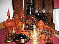 A wide range of Burmese lacquerware from Bagan (from Culture of Myanmar)
 Political map of Burma (Myanmar) c. 1450 CE. (from History of Myanmar)
 The restored Taungoo or Nyaungyan dynasty, c. 1650 CE (from History of Myanmar)
 A 19th century watercolor depicting a shinbyu procession. (from Shinbyu)
 The paddle steamer Ramapoora (right) of the British India Steam Navigation Company on the Rangoon river, having just arrived from Moulmein. 1895. Photographers: Watts and Skeen. (from History of Myanmar)
 A bull fight, 19th-century watercolour (from Culture of Myanmar)
 Grandfather Island, Dawei (from Geography of Myanmar)
 Military situation in Myanmar as of 2024. Areas controlled by the Tatmadaw are highlighted in red. (from History of Myanmar)
 The Birth of Buddha, 12th-century statue, Bagan (from Art of Myanmar)
 A group of Buddhist worshipers at Shwedagon Pagoda, an important religious site for Burmese Buddhists (from Culture of Myanmar)

 Aerial view of a burned Rohingya village in Rakhine state, September 2017 (from History of Myanmar)
 Bagan-style painting of Thingyan in Bagan (from Art of Myanmar)
 Two female musicians play the saung at a performance in Mandalay. (from Culture of Myanmar)
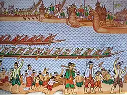 Hlei pyaingbwè - a Burmese regatta (from Culture of Myanmar)
 A wedding procession, with the groom and bride dressed in traditional Burmese wedding clothes, reminiscent of royal attire (from Culture of Myanmar)
 A large fracture on the Mingun Pahtodawgyi caused by the 1839 Ava earthquake. (from Geography of Myanmar)
 19th-century funeral cart and spire, which would form part of the procession from the home to the place of cremation (from Culture of Myanmar)
 The shores of Irrawaddy River at Nyaung-U, Bagan (from Geography of Myanmar)
 Buddha statue in Ananda Temple, Bagan (from Art of Myanmar)

 Parabaik of royal activities, 1870s–1880s (from Art of Myanmar)
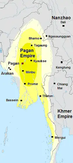 Pagan Kingdom during Narapatisithu's reign. Burmese chronicles also claim Kengtung and Chiang Mai. Core areas shown in darker yellow. Peripheral areas in light yellow. Pagan incorporated key ports of Lower Burma into its core administration by the 13th century. (from History of Myanmar)
 Recorder's Court on Sule Pagoda Road, with the Sule Pagoda at the far end, Rangoon, 1868. Photographer: J. Jackson. (from History of Myanmar)

 Salween river at Mae Sam Laep on the Thai-Myanmar border (from Geography of Myanmar)
 Hsan cha, shaving of the head. (from Shinbyu)
 Stucco on facade of Htilominlo Temple (from Art of Myanmar)
 Vegetable stall on the roadside at the Madras Lancer Lines, Mandalay, January 1886. Photographer: Hooper, Willoughby Wallace (1837–1912). (from History of Myanmar)
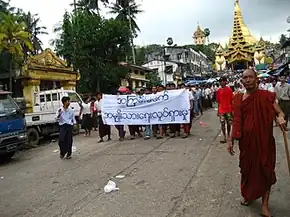 Protesters in Yangon with a banner that reads "non-violence: national movement" in Burmese. In the background is Shwedagon Pagoda. (from History of Myanmar)
 British soldiers dismantling cannons belonging to King Thibaw's forces, Third Anglo-Burmese War, Ava, 27 November 1885. Photographer: Hooper, Willoughby Wallace (1837–1912). (from History of Myanmar)

 British soldiers remove their shoes at the entrance of Shwedagon Pagoda. To the left, a sign reads "Foot wearing is strictly prohibited" in Burmese, English, Tamil, and Urdu. (from Culture of Myanmar)
 Portuguese ruler and soldiers mounting an elephant. Jan Caspar Philips (draughtsman and engraver). (from History of Myanmar)
 Former US President Barack Obama poses barefoot on the grounds of Shwedagon Pagoda, one of Myanmar's major Buddhist pilgrimage sites. (from Culture of Myanmar)
 Awakening of Buddha Taṇhaṅkara, Wall Painting in Upali Thein Temple, Bagan (from Art of Myanmar)
 Mountains near Pindaya on the Shan Plateau (from Geography of Myanmar)
 British soldiers on patrol in the ruins of the Burmese town of Bahe during the advance on Mandalay, January 1945 (from History of Myanmar)

 Myinhkin thabin - equestrian sport (from Culture of Myanmar)
 Myanmar (Burma) map of Köppen climate classification (from Geography of Myanmar)
 Jade Mine in Hpakant (from Geography of Myanmar)

 Crowned and jeweled Buddha sitting on an elephant throne; circa 1890; Art Institute of Chicago (USA) (from Art of Myanmar)
 A theatrical performance of the Mon dance (from Culture of Myanmar)
 A boy donning white monastic robes before being ordained as a samanera (shin thamane) (from Shinbyu)




 Commons
 Wikidata
 Wikiquote
 Wikisource
 Wikiversity
 Wikivoyage
 Wiktionary
 List of all portals





 Random portal
 WikiProject Portals