Portal:Maps

| Main page | Maps |
The Maps and Cartography Portal
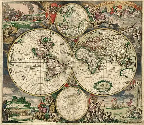
In cartography, a map is a representation or abstraction of geographic reality. Maps are used for a wide range of purposes, including navigation, scientific research, governance, and warfare. A common use is route planning, which enables users to find their way to their destination. Specialized maps, called charts, are used for nautical navigation (nautical charts) and aviation (aeronautical charts). Scientists use maps to organize spatial data in fields such as geology, meteorology, seismology and demographics. Governments use maps for administrative functions such as census, electoral districts, property taxation, dispatching police, and coordinating disaster relief. Military and security organizations use maps for mission planning, surveillance, border management, logistics, and intelligence analysis.
One of the earliest preserved maps is from the Akkadian Empire (in modern Iraq) inscribed on a clay tablet and dated to 2300 BCE. By the 5th century BCE, Greeks were drawing maps of their known world, encompassing the Mediterranean Sea and most of Europe, North Africa, and the Middle East. Maps were important tools in the Age of Discovery, when mariners used them to explore new lands. Applications of cartography expanded in the late 17th century with the development of thematic maps, which portrayed specific kinds of data – such as rainfall or population density – rather than focusing on geographic features such as rivers, mountains, and cities. The rapid expansion of road networks and mass transit systems in the 20th century created a market for mass-produced maps aimed at the traveling public.
The development of computer cartography and geographic information systems in the mid-20th century enabled the storage of vast amounts of geographic data, which could be dynamically displayed and analyzed. Unlike paper maps, interactive maps let users zoom, pan, and choose which data to view. Geographic data used for mapmaking includes imagery, scanned paper maps, surveying measurements, geographic features, and terrain data.
Designing a map is a complex process involving the selection and arrangement of graphical elements to create a map that is informative, useful, and uncluttered. Because the amount of available geographic data often exceeds what can be effectively displayed, map designers must apply a generalization process to decide which elements to display and which to omit. The amount of detail is influenced by the map scale, expressed as a ratio between a distance on the map and the corresponding distance on the ground. The choice of a map projection is fundamental, as every projection introduces characteristic distortions. Geographic coordinates may be displayed as latitude and longitude, or in a Cartesian (XY grid) system. In addition to geographic data, maps may include supplemental elements such as legends, scale bars, north arrows, or inset maps. (Full article...)
Cartography (/kɑːrˈtɒɡrəfi/) is the study and practice of making and using maps. Combining science, aesthetics and technique, cartography builds on the premise that reality (or an imagined reality) can be modeled in ways that communicate spatial information effectively. (Full article...)
Selected article -

A compass rose or compass star, sometimes called a wind rose or rose of the winds, is a polar diagram displaying the orientation of the cardinal directions (north, east, south, and west) and their intermediate points. It is used on compasses (including magnetic ones), maps (such as compass rose networks), or monuments. It is particularly common in navigation systems, including nautical charts, non-directional beacons (NDB), VHF omnidirectional range (VOR) systems, satellite navigation devices ("GPS"). (Full article...)
General images -
 The Mercator projection with Tissot's indicatrix of deformation. (The distortion increases without limit at higher latitudes) (from Scale (map))
 Map of the “Inhabited Quarter” by Sadiq Isfahani from Jaunpur c.1647. This was one of the only surviving Indian made maps. (from History of cartography)
 Lambert's normal cylindrical equal-area projection with Tissot's indicatrix of deformation (from Scale (map))
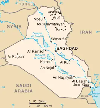 CIA map of Iraq, following typical labeling guidelines to maximize legibility and association (from Cartographic design)
 A chart of an unidentified area (from History of cartography)
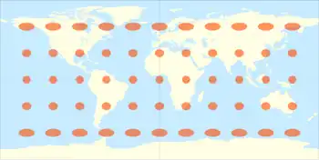 The equidistant projection with Tissot's indicatrix of deformation (from Scale (map))
 Map of Biscayne National Park, Florida, using a variety of point symbols, along with line and area symbols. Note the use of coordinated fill and stroke symbols for the national park area to solve the challenge of a water boundary. (from Cartographic design)
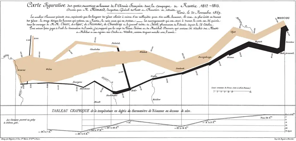 Charles Joseph Minard's map of Napoleon's Russian campaign of 1812 (1844) has been long recognized as a masterwork of cartographic design at a time when such was difficult and rare. (from Cartographic design)

 A bar scale with the nominal scale expressed as "1:600 000", meaning 1 cm on the map corresponds to 600,000 cm=6 km on the ground. (from Scale (map))
 The Equal Earth projection (2018), an increasingly popular equal-area pseudocylindrical projection for world maps (from Cartographic design)
 Surviving fragment of the first World Map of Piri Reis (1513) showing parts of the Americas. (from History of cartography)
 A portrait of a Dutch mapmaker looking up intently from his charts and holding a caliper, 1714. (from History of cartography)
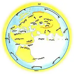 Al-Masudi's world map (10th century) (from History of cartography)
 A US civil war hachure paper map made in 1867 by cartographer Nathaniel Michler vs. modern aerial photos over Chancellorsville, Virginia (from History of cartography)
 Blaeu's world map, originally prepared by Joan Blaeu for his Atlas Maior, published in the first book of the Atlas Van Loon (1664) (from History of cartography)
 Map of the Holy Land, Pietro Vesconte, 1321. Described by Adolf Erik Nordenskiöld as "the first non-Ptolemaic map of a definite country". (from History of cartography)
 A general map of the world by Samuel Dunn, 1794, containing star chart, map of the Solar System, map of the Moon and other features along with Earth's both hemispheres. (from History of cartography)
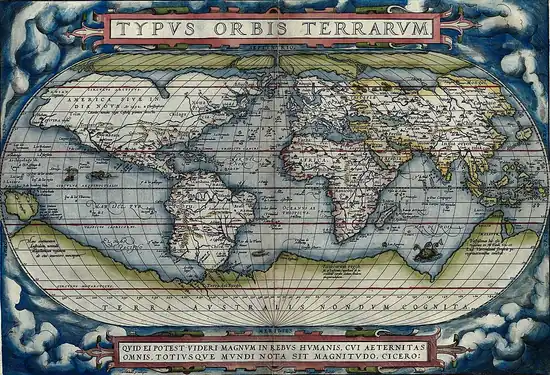
 The Mercator 1569 world map (from History of cartography)
 Universalis Cosmographia, the Waldseemüller wall map dated 1507, depicts the Americas, Africa, Europe, Asia, and the Pacific Ocean separating Asia from the Americas. (from History of cartography)
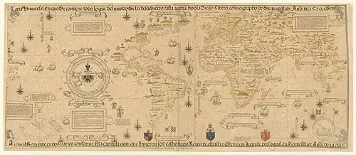 The Propaganda Map, a 1529 version of the Padrón Real now held by the Vatican Library. (from History of cartography)
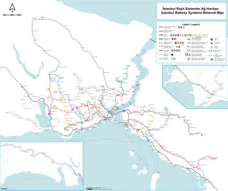 A well-composed transit map of Istanbul, with a high degree of contrast between the symbols, creating a strong visual hierarchy (transit lines are and look most important), figure-ground, and selectivity (the green national rail line can be isolated when necessary). Also note the harmonizing subdued tones of green and blue in the background. (from Cartographic design)
 Clay tablet with map of the Babylonian city of Nippur (c. 1400 BC) (from History of cartography)
 The pundit (explorer) cartographer Nain Singh Rawat (19th century) received a Royal Geographical Society gold medal in 1876. (from History of cartography)

 A graphical or bar scale. A map would also usually give its scale numerically ("1:50,000", for instance, means that one cm on the map represents 50,000cm of real space, which is 500 metres) (from Scale (map))
 Scale variation near the equator for the tangent (red) and secant (green) Mercator projections. (from Scale (map))
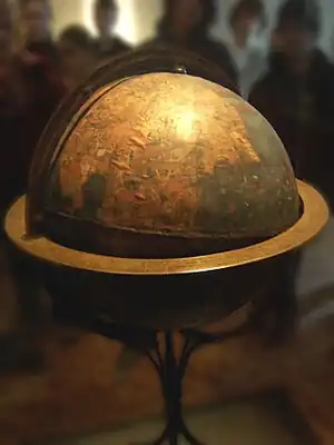 Martin Behaim's Erdapfel (1492) is considered to be the oldest surviving terrestrial globe. (from History of cartography)
 3D cartography of Washington State, Mount Rainier National Park, Pinnacle Peak trail. (from Cartographic design)
 The Tabula Rogeriana, drawn by Muhammad al-Idrisi for Roger II of Sicily in 1154. Note that the north is at the bottom, and so the map appears "upside down" compared to modern cartographic conventions. (from History of cartography)
 Infinitesimal elements on the sphere and a normal cylindrical projection (from Scale (map))
 A map of Sikkim, India using shaded relief and hypsometric tints (a form of isarithm) to visualize terrain (from Cartographic design)
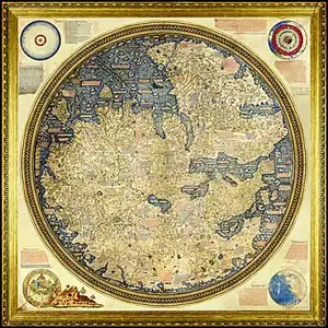 The Fra Mauro map, a medieval European map, was made around 1450 by the Italian monk Fra Mauro. It is a circular world map drawn on parchment and set in a wooden frame, about two meters in diameter. (from History of cartography)
 The world according to Hekatæus, 500 BC (from History of cartography)
 Modern version of the Roman Tabula Peutingeriana (5th century). (from History of cartography)
 The Winkel tripel projection with Tissot's indicatrix of deformation (from Scale (map))
 "Mapa de los Estados Unidos de Méjico by John Distrunell, the 1847 map used during the negotiations of the Treaty of Guadalupe Hidalgo ending the Mexican–American War. (from History of cartography)
 Reconstruction of Pomponius Mela's world map. (from History of cartography)
- Infinitesimal elements on the sphere and a normal cylindrical projection (from Scale (map))
 The Salviati Planisphere, a 1526 version of the Padrón Real provided by Charles V to the cardinal who officiated his wedding to Isabella of Portugal. (from History of cartography)
 The Da Ming Hun Yi Tu map, dating c. 1390, exists in multicolour format. (from History of cartography)
 The first Japanese printed map to depict the world, including Europe and America. Printed by woodblock in 1710, composed by the Buddhist monk Rokashi Hotan. (from History of cartography)
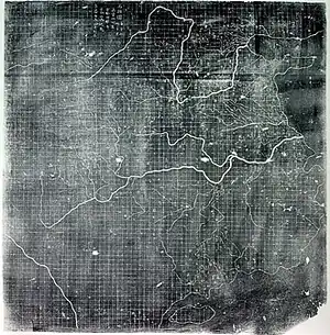 The Yu Ji Tu, or Map of the Tracks of Yu Gong, carved into stone in 1137, located in the Stele Forest of Xi'an. This 3 ft (0.91 m) squared map features a graduated scale of 100 li for each rectangular grid. China's coastline and river systems are clearly defined and precisely pinpointed on the map. Yu Gong is in reference to the Chinese deity described in the geographical chapter of the Classic of History, dated 5th century BC. (from History of cartography)
 An early Western Han dynasty (202 BC – 9 AD) silk map found in tomb 3 of Mawangdui Han tombs site, depicting the Kingdom of Changsha and Kingdom of Nanyue in southern China (note: the south direction is oriented at the top, north at the bottom). (from History of cartography)
 World Map by Juan de la Cosa (1500), the first map showing the Americas. (from History of cartography)
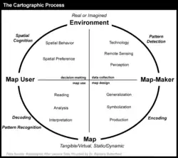 The cartographic process (from Cartographic design)
 A chorochromatic map of world land cover, using hue, value, and saturation to differentiate nominal values (from Cartographic design)
 Possibly the oldest surviving map has been engraved on this mammoth tusk, dated to 25,000 BC, found from Pavlov in the Czech Republic. (from History of cartography)
 Scale variation for the Lambert (green) and Gall (red) equal area projections. (from Scale (map))
 Nautical chart by Pedro Reinel (c. 1504), one of the first based on astronomical observations and to depict a scale of latitudes. (from History of cartography)
Selected quote
| “ | Map me no maps. | ” |
| — Henry Fielding, Rape upon Rape, 1730 | ||
Related portals
Related WikiProjects

Selected biography -

Leonardo di ser Piero da Vinci (15 April 1452–2 May 1519) was an Italian polymath of the High Renaissance who was active as a painter, draughtsman, engineer, scientist, theorist, sculptor, and architect. While his fame initially rested on his achievements as a painter, he has also become known for his notebooks, in which he made drawings and notes on a variety of subjects, including anatomy, astronomy, botany, cartography, painting, and palaeontology. Leonardo is widely regarded as a genius who epitomised the Renaissance humanist ideal, and his collective works contributed to the development of European art to an extent rivalled only by that of his younger contemporary Michelangelo.
Born out of wedlock to a successful notary and a lower-class woman in (or near) Vinci in Tuscany, he was educated in Florence by the Italian painter and sculptor Andrea del Verrocchio. He began his career in the city, but then spent much time in the service of Ludovico Sforza in Milan. Later, he worked in Florence and Milan again, as well as briefly in Rome, all while attracting a large following of imitators and students. Upon the invitation of Francis I, he spent his last three years in France, where he died in 1519. Since his death, there has not been a time when his achievements, diverse interests, personal life, and empirical thinking have failed to incite interest and admiration, making him a frequent namesake and subject in culture. (Full article...)
Selected picture

Did you know
- ... that the Canadian League for Peace and Democracy organized a 10,000-person rally at Maple Leaf Gardens in Toronto to protest a 2,500-person fascist rally?
- ... that Kathryn Maple won the Sunday Times Watercolour Competition twice in three years?
- ... that Maki Narukido researched the characters' travel times in her manga The End of the World With You using Google Maps?
- ... that Bartholomäus Scultetus tried to become the court cartographer of Ivan the Terrible?
- ... that Kaneza Schaal and Christopher Myers created Cartography after seeing a young boy playing music?
Topics
Map - Atlas - Geography - Topography
Cartography: Cartographers - History of cartography - Ancient world maps - World maps - Compass rose - Generalization - Geographic coordinate system - Geovisualization - Relief depiction - Scale - Terra incognita - Planetary cartography
Map projection: Azimuthal equidistant - "Butterfly" - Dymaxion - Gall–Peters - General Perspective - Goode homolosine - Mercator - Mollweide - Orthographic - Peirce quincuncial - Robinson - Sinusoidal - Stereographic
Maps: Animated mapping - Cartogram - Choropleth map - Estate map - Geologic map - Linguistic map - Nautical chart - Pictorial map - Reversed map - Road atlas - Thematic map - Topographic map - Weather map - Web mapping - World map
Map examples
World
Historical
Thematic

Geographic

Political

Nautical
Categories

Things you can do
|
|
WikiProject: Geography
Here are some Geography related tasks you can do:
|

Atlases and maps of the world at Wikimedia Commons
Associated Wikimedia
The following Wikimedia Foundation sister projects provide more on this subject:
-
 Commons
Free media repository -
 Wikidata
Free knowledge base -
 Wikiquote
Collection of quotations -
 Wikisource
Free-content library -
 Wikiversity
Free learning tools -
 Wiktionary
Dictionary and thesaurus
-
 List of all portals
-

-

-

-
-

-

-

-

-

-
 Random portal
-
 WikiProject Portals