Strandabyggð
Strandabyggð | |
|---|---|
 Coat of arms | |
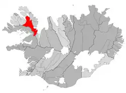 Location of the municipality | |
  Strandabyggð Location within Iceland | |
| Coordinates: 65°42′24″N 21°39′55″W / 65.706700°N 21.665320°W | |
| Country | Iceland |
| Region | Westfjords |
| Constituency | Northwest Constituency |
| Established | 10.06.2006 |
| Government | |
| • Manager | Þorgeir Pálsson |
| Area | |
• Total | 1,906 km2 (736 sq mi) |
| Population | |
• Total | 449 |
| • Density | 0.24/km2 (0.62/sq mi) |
| Postal code(s) | 510, 512 |
| Municipal number | 4911 |
| Website | strandabyggd |
Strandabyggð (Icelandic pronunciation: [ˈstrantaˌpɪɣθ] ⓘ) is a municipality, formed in 2006 when the districts Hólmavík and Broddaneshrepp merged, located in northwestern Iceland.[1]
References
- ↑ "Strandabyggð". RÚV (in Icelandic). 2 May 2014. Retrieved 1 August 2026.