Pra River (Ghana)
| Pra River | |
|---|---|
 | |
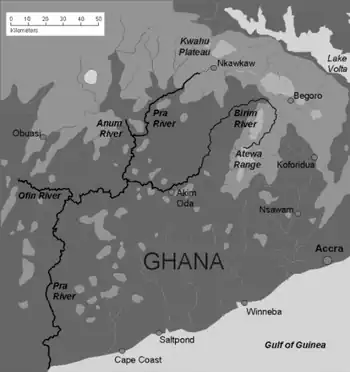 Pra River and major tributaries | |
| Physical characteristics | |
| Length | 240 km (150 mi) |
The Pra River is a river in Ghana, It is the easternmost and the largest of the three principal rivers that drain the area south of the Volta divide. Rising in the Kwahu Plateau near Mpraeso and flowing 240 km (149.129 mi) southward through rich cocoa and farming areas and valuable forests in the Akan lowlands. The Pra enters the Gulf of Guinea east of Takoradi.[1] In the 19th century, the Pra served as the border between the Ashanti Confederacy and the Gold Coast.
The Pra has many cataracts, notably the Bosomasi Rapids at Anyinabrim, and most of its length is not navigable even by canoe. However, in the early part of the twentieth century the Pra was used extensively to float timber to the coast for export. This trade is now carried by road and rail transportation. The main tributaries are the Ofin, Anum and Birim rivers. The northern part of the Pra is still worked for artisan gold with metallic mercury, which has caused some contamination.[2] The Birim river valley is a major source of diamonds.
Tributaries and Physical Characteristics
The main tributaries of the Pra River include the Ofin, Birim, Anum, and Oda rivers.[3]
The river is characterized by rapids and cataracts, which make navigation difficult along most of its course.[4]
Its basin includes diverse landscapes such as forest zones, agricultural lands, and mineral-rich areas.[5]
Environmental Issues and Pollution
The Pra River is heavily affected by illegal small-scale mining activities (galamsey), which introduce mercury and sediments into the water system.[5]
Studies show that water quality in many parts of the basin exceeds WHO limits for parameters such as iron and lead contamination.[6]
Climate and Hydrological Challenges
The Pra Basin is experiencing increasing climate variability, including higher temperatures and more extreme rainfall events.[7]
These changes increase risks of flooding, drought stress, and water insecurity across the basin.[7]
Hydrological studies show that land-use change significantly affects runoff and water balance in the basin.[8]
Akim Oda is the commercial centre of the northern Pra basin.
References
- ↑ "Ghana – Landforms". commonwealth.ednet.ns. Archived from the original on 19 December 2008. Retrieved 18 March 2009.
- ↑ "Mercury in different environmental compartments of the Pra River Basin, Ghana". Centre national de la recherche scientifique. Retrieved 18 March 2009.
- ↑ "Pra River-Water Resources Commission".
- ↑ "Pra | River, Ghana, Length, & Facts | Britannica". Encyclopedia Britannica. Retrieved 16 June 2026.
- 1 2 Awotwi, Alfred; Anornu, Geophrey Kwame; Quaye-Ballard, Jonathan; Annor, Thompson; Forkuo, Eric Kwabena (December 2017). "Analysis of climate and anthropogenic impacts on runoff in the Lower Pra River Basin of Ghana". Heliyon. 3 (12) e00477. Bibcode:2017Heliy...300477A. doi:10.1016/j.heliyon.2017.e00477. ISSN 2405-8440. PMC 5753612. PMID 29322102.
- ↑ Bessah, Enoch; Raji, Abdulganiy O.; Taiwo, Olalekan J.; Agodzo, Sampson K.; Ololade, Olusola O.; Strapasson, Alexandre; Donkor, Emmanuel (1 December 2021). "Assessment of surface waters and pollution impacts in Southern Ghana". Hydrology Research. 52 (6): 1423–1435. Bibcode:2021HydR...52.1423B. doi:10.2166/nh.2021.051. ISSN 0029-1277.
- 1 2 GNA (23 October 2025). "Pra River Basin experiencing extreme weather conditions". Ghana News Agency. Retrieved 16 June 2026.
- ↑ Awotwi, Alfred; Anornu, Geophrey Kwame; Quaye-Ballard, Jonathan Arthur; Annor, Thompson; Forkuo, Eric Kwabena; Harris, Emmanuel; Agyekum, Jacob; Terlabie, John Lawer (November 2019). "Water balance responses to land-use/land-cover changes in the Pra River Basin of Ghana, 1986–2025". CATENA. 182 104129. Bibcode:2019Caten.18204129A. doi:10.1016/j.catena.2019.104129.
External links

- "Fish Species in Pra River". Monga Bay. Retrieved 18 March 2009.