Portal:Washington (state)

The Washington Portal Panoramic view from Washington Pass Observation Site (a.k.a. Washington Pass Overlook), Okanogan County, Washington (2023)
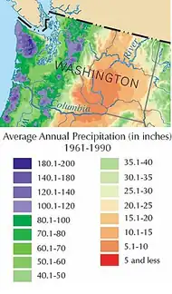
 Washington is a state in the Pacific Northwest region of the United States. It is often referred to as Washington state to distinguish it from the national capital; both are named after George Washington, a U.S. Founding Father and the first U.S. president. Washington borders the Pacific Ocean to the west, Oregon to the south, and Idaho to the east; it shares an international border with the Canadian province of British Columbia to the north. Olympia is the state capital, and the state's most populous city is Seattle. Washington is the 18th-largest state, with an area of 71,362 sq mi (184,830 km2), and the 13th-most populous state, with a population of over 8 million. The majority of Washington's residents live in the Seattle metropolitan area, the center of transportation, business, and industry on Puget Sound, an inlet of the Pacific Ocean consisting of numerous islands, deep fjords and bays carved out by glaciers. The remainder of the state consists of deep temperate rainforests in the west; mountain ranges in the west, center, northeast, and far southeast, and a semi-arid basin region in the east, center, and south, given over to intensive agriculture. Washington is the second-most populous state on the West Coast and in the Western United States, after California. Mount Rainier, an active stratovolcano, is the state's highest elevation at 14,400 feet (4,389 meters), and is the most topographically prominent mountain in the contiguous U.S. Washington is a leading lumber producer, the largest producer of apples, hops, pears, blueberries, spearmint oil, and sweet cherries in the U.S., and ranks high in the production of apricots, asparagus, dry edible peas, grapes, lentils, peppermint oil, potatoes and wheat. Livestock, livestock products, and commercial fishing—particularly of salmon, halibut, and bottomfish—are also significant contributors to the state's economy. Washington ranks third in wine production. Manufacturing industries in Washington include aircraft, missiles, shipbuilding, and other transportation equipment, food processing, metals, and metal products, chemicals, and machinery. (Full article...)
| ||||||||||||||||||||||||||||||||||||||||||||||||||||










| Federal |
| ||||||||||||||||||||||||||||
|---|---|---|---|---|---|---|---|---|---|---|---|---|---|---|---|---|---|---|---|---|---|---|---|---|---|---|---|---|---|
| State |
| ||||||||||||||||||||||||||||
| Other |
| ||||||||||||||||||||||||||||

Categories

New articles
This list was generated from these rules. Questions and feedback are always welcome! The search is being run daily with the most recent ~14 days of results. Note: Some articles may not be relevant to this project.
Rules | Match log | Results page (for watching) | Deleted articles| Last updated: 2026-08-30 20:45 (UTC)
Note: The list display can now be customized by each user. See List display personalization for details.
- Senator Swanson (disambiguation) (edit | talk | history | links | watch | logs | tools | Portal:Washington (Q10815220) ) by PA Uploader (talk · contribs · new pages (288)) started on 2026-08-30, score: 28
- King County Search and Rescue (edit | talk | history | links | watch | logs | tools | Portal:Washington (Q10815220) ) by Buidhe (talk · contribs · new pages (5)) started on 2026-08-29, score: 62
- Ajahn Nisabho (edit | talk | history | links | watch | logs | tools | Ajahn Nisabho (Q141217984) ) by Garisti (talk · contribs · new pages (11)) started on 2026-08-29, score: 21
- Ajahn Kovilo (edit | talk | history | links | watch | logs | tools | Ajahn Kovilo (Q141217930) ) by Garisti (talk · contribs · new pages (11)) started on 2026-08-29, score: 21
- Clear Mountain Monastery (edit | talk | history | links | watch | logs | tools | Clear Mountain Monastery (Q141216551) ) by Garisti (talk · contribs · new pages (11)) started on 2026-08-29, score: 33
- Ronald E. Walters (edit | talk | history | links | watch | logs | tools | Ronald E. Walters (Q141222357) ) by VasileArsenie (talk · contribs · new pages (12)) started on 2026-08-25, score: 24
- San Diego State University Marching Aztecs (edit | talk | history | links | watch | logs | tools | Portal:Washington (Q10815220) ) by Antriot (talk · contribs · new pages (4)) started on 2026-08-29, score: 28
- Mr. Epp And The Calculations (edit | talk | history | links | watch | logs | tools | Portal:Washington (Q10815220) ) by Juventinopw2 (talk · contribs · new pages (1)) started on 2026-08-29, score: 48
- Kenneth Dodson (edit | talk | history | links | watch | logs | tools | Kenneth Dodson (Q94126793) ) by MoviesandTelevisionFan (talk · contribs · new pages (101)) started on 2026-08-29, score: 34
- Uptown Espresso (edit | talk | history | links | watch | logs | tools | Uptown Espresso (Q141205952) ) by Another Believer (talk · contribs · new pages (54)) started on 2026-08-28, score: 48
- Tennessee House of Representatives 6th District (edit | talk | history | links | watch | logs | tools | Portal:Washington (Q10815220) ) by Basileus121 (talk · contribs · new pages (6)) started on 2026-08-28, score: 20
- Frank Richter (American football) (edit | talk | history | links | watch | logs | tools | Frank Richter (Q141222402) ) by WikiOriginal-9 (talk · contribs · new pages (118)) started on 2026-08-28, score: 34
- Mikhail Kogan (physician) (edit | talk | history | links | watch | logs | tools | Portal:Washington (Q10815220) ) by Powerviki (talk · contribs · new pages (1)) started on 2026-08-28, score: 24
- Jeffery Dagle (edit | talk | history | links | watch | logs | tools | Jeffery Dagle (Q141198300) ) by MoviesandTelevisionFan (talk · contribs · new pages (101)) started on 2026-08-27, score: 48
- Luis Perales (edit | talk | history | links | watch | logs | tools | Luis Perales (Q139737081) ) by Kudzu1 (talk · contribs · new pages (1)) started on 2026-08-27, score: 34
- Frank and Jane Phillips House (edit | talk | history | links | watch | logs | tools | Frank and Jane Phillips House (Q139300886) ) by Epicgenius (talk · contribs · new pages (57)) started on 2026-08-27, score: 20
- Johnny Taylor (American football) (edit | talk | history | links | watch | logs | tools | Johnny Taylor (Q141193371) ) by WikiOriginal-9 (talk · contribs · new pages (118)) started on 2026-08-27, score: 28
- John P. Rutherfoord (edit | talk | history | links | watch | logs | tools | John P. Rutherfoord (Q54183417) ) by Grand'mere Eugene (talk · contribs · new pages (3)) started on 2026-08-25, score: 34
- Bibliography of Alexander Hamilton (edit | talk | history | links | watch | logs | tools | bibliography of Alexander Hamilton (Q141189170) ) by TimothyBlue (talk · contribs · new pages (22)) started on 2026-08-24, score: 24
- Erin Malone (edit | talk | history | links | watch | logs | tools | Portal:Washington (Q10815220) ) by ~2026-45752-51 (talk · contribs · new pages (0)) started on 2026-08-22, score: 34
- Kent Sullivan (edit | talk | history | links | watch | logs | tools | Kent Sullivan (Q108053341) ) by WikiOriginal-9 (talk · contribs · new pages (118)) started on 2026-08-25, score: 34
- 194 (edit | talk | history | links | watch | logs | tools | 194 (Q395992) ) by BilledMammal (talk · contribs · new pages (131)) started on 2026-08-25, score: 24
- 193 (edit | talk | history | links | watch | logs | tools | 193 (Q395718) ) by BilledMammal (talk · contribs · new pages (131)) started on 2026-08-25, score: 28
- Derek Sheffield (edit | talk | history | links | watch | logs | tools | Portal:Washington (Q10815220) ) by ~2026-45752-51 (talk · contribs · new pages (0)) started on 2026-08-21, score: 38
- Union Arts Center (edit | talk | history | links | watch | logs | tools | ACT Theatre (Q4650897) ) by Shortride (talk · contribs · new pages (8)) started on 2026-08-24, score: 55
- Ken Times (edit | talk | history | links | watch | logs | tools | Ken Times (Q108053185) ) by WikiOriginal-9 (talk · contribs · new pages (118)) started on 2026-08-24, score: 32
- Bryant Winn (edit | talk | history | links | watch | logs | tools | Bryant Winn (Q108053127) ) by WikiOriginal-9 (talk · contribs · new pages (118)) started on 2026-08-24, score: 48
- 2023 Washington Freedom season (edit | talk | history | links | watch | logs | tools | 2023 Washington Freedom Season (Q125856042) ) by Sagarsq (talk · contribs · new pages (62)) started on 2026-08-24, score: 68
- 2024 Washington Freedom season (edit | talk | history | links | watch | logs | tools | Portal:Washington (Q10815220) ) by Sagarsq (talk · contribs · new pages (62)) started on 2026-08-24, score: 61
- 2026–27 Washington Huskies men's basketball team (edit | talk | history | links | watch | logs | tools | Portal:Washington (Q10815220) ) by Publicwalrus (talk · contribs · new pages (18)) started on 2026-08-23, score: 62
- Erik Tolman (edit | talk | history | links | watch | logs | tools | Erik Tolman (Q141131338) ) by Yankees10 (talk · contribs · new pages (18)) started on 2026-08-19, score: 34
- Brandon Korff (edit | talk | history | links | watch | logs | tools | Brandon Korff (Q133504778) ) by Terabyte646 (talk · contribs · new pages (21)) started on 2026-08-22, score: 24
- Hanneline Røgeberg (edit | talk | history | links | watch | logs | tools | Hanneline Røgeberg (Q28922859) ) by Miraclepine (talk · contribs · new pages (18)) started on 2026-08-22, score: 27
- Columbia Hills AVA (edit | talk | history | links | watch | logs | tools | Portal:Washington (Q10815220) ) by Bf2002 (talk · contribs · new pages (1)) started on 2026-08-21, score: 44
- Jim Canady (edit | talk | history | links | watch | logs | tools | Jim Canady (Q108053420) ) by KerbHopper (talk · contribs · new pages (86)) started on 2026-08-21, score: 30
- Kylee Lahners (edit | talk | history | links | watch | logs | tools | Kylee Lahners (Q141142542) ) by SwedishDrachma (talk · contribs · new pages (16)) started on 2026-08-21, score: 34
- Zaay Green (edit | talk | history | links | watch | logs | tools | Portal:Washington (Q10815220) ) by SwedishDrachma (talk · contribs · new pages (16)) started on 2026-08-21, score: 34
- John Wunder (edit | talk | history | links | watch | logs | tools | John Wunder (Q141139161) ) by Hepplerj (talk · contribs · new pages (2)) started on 2026-08-21, score: 34
- Front and Back Dollar Bills (edit | talk | history | links | watch | logs | tools | Portal:Washington (Q10815220) ) by Twixister (talk · contribs · new pages (9)) started on 2026-08-21, score: 22
- Al Siniscal (edit | talk | history | links | watch | logs | tools | Al Siniscal (Q141142298) ) by Ktkvtsh (talk · contribs · new pages (13)) started on 2026-08-21, score: 34
- P. L. Cady (edit | talk | history | links | watch | logs | tools | P. L. Cady (Q141138391) ) by PA Uploader (talk · contribs · new pages (288)) started on 2026-08-21, score: 20
- Bryce Butler (edit | talk | history | links | watch | logs | tools | Bryce Butler (Q141150801) ) by KerbHopper (talk · contribs · new pages (86)) started on 2026-08-21, score: 30
- Joseph Gastwirth (edit | talk | history | links | watch | logs | tools | Joseph Gastwirth (Q102205261) ) by Attractive Opposite (talk · contribs · new pages (2)) started on 2026-08-20, score: 24
- 2026–27 Washington Huskies women's basketball team (edit | talk | history | links | watch | logs | tools | Portal:Washington (Q10815220) ) by Bremerton98310 (talk · contribs · new pages (12)) started on 2026-08-20, score: 51
- 200 One Dollar Bills (edit | talk | history | links | watch | logs | tools | Portal:Washington (Q10815220) ) by Twixister (talk · contribs · new pages (9)) started on 2026-08-17, score: 22
- One Dollar Bill (Silver Certificate) (edit | talk | history | links | watch | logs | tools | Portal:Washington (Q10815220) ) by Twixister (talk · contribs · new pages (9)) started on 2026-08-17, score: 22
- Tennessee House of Representatives 7th district (edit | talk | history | links | watch | logs | tools | Portal:Washington (Q10815220) ) by Basileus121 (talk · contribs · new pages (6)) started on 2026-08-20, score: 20
- Diplacus cusickioides (edit | talk | history | links | watch | logs | tools | Diplacus cusickioides (Q17746311) ) by Tom Radulovich (talk · contribs · new pages (42)) started on 2026-08-20, score: 26
- Loveless Building (edit | talk | history | links | watch | logs | tools | Loveless Building (Q141145075) ) by HestHorse (talk · contribs · new pages (2)) started on 2026-08-19, score: 28
- Angelo Calfo (edit | talk | history | links | watch | logs | tools | Angelo Calfo (Q118289663) ) by Razorramos (talk · contribs · new pages (1)) started on 2026-08-19, score: 28
- Hiawatha Playfield and Community Center (edit | talk | history | links | watch | logs | tools | Portal:Washington (Q10815220) ) by WikiWanderer23 (talk · contribs · new pages (4)) started on 2026-08-19, score: 28
- Senator McEwen (edit | talk | history | links | watch | logs | tools | Senator McEwen (Q141123697) ) by PA Uploader (talk · contribs · new pages (288)) started on 2026-08-18, score: 28
- Senator McCutcheon (edit | talk | history | links | watch | logs | tools | Senator McCutcheon (Q141128375) ) by PA Uploader (talk · contribs · new pages (288)) started on 2026-08-18, score: 28
- Set the Dial (edit | talk | history | links | watch | logs | tools | Portal:Washington (Q10815220) ) by Jericho735 (talk · contribs · new pages (10)) started on 2026-08-18, score: 28
- Senator Ludwig (edit | talk | history | links | watch | logs | tools | Senator Ludwig (Q141118682) ) by PA Uploader (talk · contribs · new pages (288)) started on 2026-08-18, score: 28
- Senator Kohl (disambiguation) (edit | talk | history | links | watch | logs | tools | Portal:Washington (Q10815220) ) by PA Uploader (talk · contribs · new pages (288)) started on 2026-08-17, score: 24
- Edith Mirick (edit | talk | history | links | watch | logs | tools | Edith Mirick (Q141112237) ) by Alizardbreath (talk · contribs · new pages (2)) started on 2026-08-17, score: 22
- Spokane free speech fight (edit | talk | history | links | watch | logs | tools | Portal:Washington (Q10815220) ) by Generalissima (talk · contribs · new pages (11)) started on 2026-08-15, score: 24
- Jerrell Pippens (edit | talk | history | links | watch | logs | tools | Jerrell Pippens (Q108051631) ) by WikiOriginal-9 (talk · contribs · new pages (118)) started on 2026-08-17, score: 32
- Senator Jolly (edit | talk | history | links | watch | logs | tools | Senator Jolly (Q141108498) ) by PA Uploader (talk · contribs · new pages (288)) started on 2026-08-17, score: 28
- Mathis Picard (edit | talk | history | links | watch | logs | tools | Mathis Picard (Q99677834) ) by Absurdum4242 (talk · contribs · new pages (39)) started on 2026-08-17, score: 28
- Senator Houser (edit | talk | history | links | watch | logs | tools | Senator Houser (Q141108483) ) by PA Uploader (talk · contribs · new pages (288)) started on 2026-08-16, score: 28
- Senator Houghton (edit | talk | history | links | watch | logs | tools | Senator Houghton (Q141108481) ) by PA Uploader (talk · contribs · new pages (288)) started on 2026-08-16, score: 28
- Sinlahekin Fire (edit | talk | history | links | watch | logs | tools | Portal:Washington (Q10815220) ) by Bri (talk · contribs · new pages (9)) started on 2026-08-16, score: 61
- Joseph Anderson Glasgow (edit | talk | history | links | watch | logs | tools | Joseph Anderson Glasgow (Q104874519) ) by DMVHistorian (talk · contribs · new pages (29)) started on 2026-08-16, score: 27
- George C. Wilson (edit | talk | history | links | watch | logs | tools | George C. Wilson (Q141104783) ) by Jim20007 (talk · contribs · new pages (0)) started on 2026-08-15, score: 34
- Cassius M. Coe (edit | talk | history | links | watch | logs | tools | Cassius M. Coe (Q141102601) ) by Amateur genealogy (talk · contribs · new pages (5)) started on 2026-08-11, score: 48
- Keith Cheng (edit | talk | history | links | watch | logs | tools | Keith C Cheng (Q54217061) ) by ~2026-40969-38 (talk · contribs · new pages (0)) started on 2026-08-08, score: 34
WikiProjects

- WikiProject Washington
- WikiProject United States
Tasks
 |
Here are some tasks awaiting attention:
|
Associated Wikimedia
The following Wikimedia Foundation sister projects provide more on this subject:
-
 Commons
Free media repository -
 Wikidata
Free knowledge base -
 Wikiquote
Collection of quotations -
 Wikisource
Free-content library -
 Wikiversity
Free learning tools -
 Wikivoyage
Free travel guide -
 Wiktionary
Dictionary and thesaurus
Sources
-
 List of all portals
-

-

-

-

-

-

-

-

-

-
 Random portal
-
 WikiProject Portals