Nine Mile station
Nine Mile   | ||||||||||||||||
|---|---|---|---|---|---|---|---|---|---|---|---|---|---|---|---|---|
 | ||||||||||||||||
| General information | ||||||||||||||||
| Location | 3179 South Parker Road[1] Aurora, Colorado | |||||||||||||||
| Coordinates | 39°39′28″N 104°50′41″W / 39.6577°N 104.8446°W | |||||||||||||||
| Owner | Regional Transportation District | |||||||||||||||
| Line | Southeast Corridor[2] | |||||||||||||||
| Platforms | 1 island platform | |||||||||||||||
| Tracks | 2 | |||||||||||||||
| Connections |
| |||||||||||||||
| Construction | ||||||||||||||||
Structure type | Freeway median, above grade | |||||||||||||||
| Parking | 1,225 spaces,[3] | |||||||||||||||
Cycle facilities | 16 racks, 28 lockers, Colorado Front Range Trail | |||||||||||||||
| Accessible | Yes | |||||||||||||||
| History | ||||||||||||||||
| Opened | November 17, 2006 | |||||||||||||||
| Passengers | ||||||||||||||||
| 2025 | 1,629 (average daily) | |||||||||||||||
| Rank | 20 out of 75 | |||||||||||||||
| Services | ||||||||||||||||
| ||||||||||||||||
| ||||||||||||||||
| ||||||||||||||||

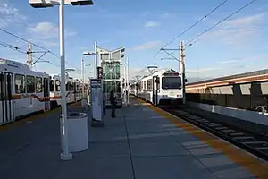
Nine Mile station is an RTD light rail station in Aurora, Colorado, United States.[4] The station opened on November 17, 2006, and is operated by the Regional Transportation District as part of the H and R lines.[4][5] When it opened in 2006, it was the outbound terminus of the H Line.[6] After the R Line began operations in 2017, the terminus of the H Line was extended northeast to Florida station.
Station layout
| 2F
Platform Level |
←  I-225 northbound | |
| Northbound | ← toward Florida (Iliff) ← toward Peoria (Iliff) | |
| Island platform, doors will open on the left | ||
| Southbound | toward 18th & California (Dayton) → toward Lincoln (Dayton) → | |
| I-225 southbound → | ||
| 1F | Pedestrian tunnel | |
 SH 83 / Parker Road; bus bays; parking | ||
The station is in the median of Interstate 225. A pedestrian tunnel under the southbound lanes links the station to its bus bays and parking lot, located in the middle of the interchange between I-225 and Parker Road. The station serves as a major transit hub for southeast Denver and south Aurora. The AT and ATA bus routes provide nonstop service from Nine Mile to Denver International Airport, often completing the journey quicker (albeit much less frequently) than the R Line.
Nine Mile station is named after, and built at the approximate location of, the historic Nine Mile House, one of several stage stops along the Smoky Hill Trail. This stop was nine miles from Denver.[7][8]
References
- ↑ Regional Transportation District Light rail system map. Accessed 2009-11-02.
- ↑ "Southeast Corridor Light Rail Line". RTD - Denver. March 2018. Archived from the original on February 27, 2022. Retrieved February 27, 2022.
- ↑ "Alphabetical park-n-Ride List". Regional Transportation District. Archived from the original on September 17, 2010. Retrieved September 26, 2010.
- 1 2 Leib, Jeffrey (November 21, 2006). "A rail easy commute SE line's regular service debuts smoothly". The Denver Post. p. A1.
- ↑ "RTD: Southeast Corridor" (PDF). Regional Transportation District. Archived from the original (PDF) on September 28, 2011. Retrieved September 26, 2010.
- ↑ "Light rail system map". Regional Transportation District. Retrieved September 26, 2010.
- ↑ "Cherokee and Smoky Hill Trails". Parker Area Historical Society — Parker Colorado. Parker Area Historical Society. Retrieved December 5, 2016.
- ↑ "Nomination Form for Seventeen Mile House, National Register of Historic Places Inventory". National Park Service - NPGallery. National Park Service. Retrieved December 5, 2016.
Regional Transportation District bus and rail services | |||||||||||
|---|---|---|---|---|---|---|---|---|---|---|---|
| Operators |
|  | |||||||||
| Rail services |
| ||||||||||
| Bus services | |||||||||||
| Other topics | |||||||||||


