Conicavel
| Conicavel | |
|---|---|
 Conicavel village, 2025 | |
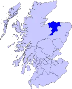
  Conicavel Location within Moray | |
| OS grid reference | NH9953 |
| Council area | |
| Lieutenancy area | |
| Country | Scotland |
| Sovereign state | United Kingdom |
| Post town | FORRES |
| Postcode district | IV36 |
| Police | Scotland |
| Fire | Scottish |
| Ambulance | Scottish |
Conicavel is a small settlement in Moray, Scotland, situated south-west of Forres on the edge of Darnaway Forest and a short distance west of the River Findhorn.[1] The settlement lies in the historic civil parish of Edinkillie and forms part of the Dyke Landward Community Council area.[2][3]
The village developed in association with the neighbouring Darnaway Estate, and a number of its surviving early nineteenth-century cottages were constructed to accommodate commercial salmon fishermen working on the nearby Findhorn.[3] Conicavel is now principally a residential rural settlement surrounded by farmland and extensive woodland.
History
Conicavel's history is closely connected with the Darnaway Estate, the principal seat of the Earl of Moray. Darnaway Forest has a much older history than the settlement itself: woodland in the area formed part of a medieval royal hunting forest, and the cutting of oak there is recorded as early as the 13th century.[4] Extensive planting subsequently transformed the estate, particularly from the 18th century onwards, while systematic commercial forestry was developed during the later 19th century.[4]
Many of the historic buildings of Conicavel developed during the 19th century as part of the estate.[3] Numbers 43 and 43B, known as Dowans and Sharpies, are an early 19th-century pair of estate cottages, constructed of rubble with ashlar stone dressings and local slate roofs.[5] Numbers 44 and 45 are of similar date and design.[6] These are Category B listed buildings.[3][5][6]
Another surviving building, Bunties at No. 38 Conicavel, dates from the mid-19th century and is Category C listed.[7] The surviving buildings therefore preserve much of the character of the 19th-century estate settlement.
Conicavel also formerly had its own school which was subsequently used as a post office.[8]
Geography

Conicavel lies at grid reference NH9953 in the rural countryside between Forres and the middle reaches of the River Findhorn.[9] It is approached by minor roads from the direction of Darnaway and Brodie and lies on the northern edge of the extensive Darnaway Forest.[4] Darnaway Forest contains both commercial plantations and older woodland. Historic Environment Scotland records that the estate's plantations have been progressively developed since at least the mid-18th century and that a major period of commercial forestry began after Daniel Scott was appointed estate forester in 1872.[4] Woodland walks were subsequently laid out through the estate,and paths south of Conicavel continue towards Dun Earn and the River Findhorn.[10]
River Findhorn
The River Findhorn flows through a steep wooded gorge east and south-east of Conicavel. The Darnaway stretches of the river contain a series of traditional salmon fishing pools, and access to part of the estate's Lower Home fishing beat is through Darnaway Forest from Conicavel.[11] Salmon fishing consequently played an important part in the historic economy of the settlement, as demonstrated by the estate cottages constructed specifically for commercial fishermen.[3] The gorge forms part of the wider Lower Findhorn Woods, a designated Special Area of Conservation. The protected area extends along approximately 7 km (4.3 mi) of the river and contains ancient semi-natural woodland on the steep gorge sides.[12]
Nearby places of interest
Immediately north of Conicavel is Darnaway Castle, the historic seat of the Earls of Moray. The present Category A listed castellated mansion was largely built between 1802 and 1812 to designs by Alexander Laing, but incorporates the much older Randolph's Hall, dating from about 1450.[13] The hall retains a medieval timber roof and is incorporated into the south side of the later mansion.[13] The castle stands within an extensive designed landscape of woodland, drives, an arboretum and gardens.[4]
South of Conicavel, paths through Darnaway Forest lead towards Dunearn (a pehistoric hillfort) and the western side of the Findhorn gorge. The Dunearn path begins about a mile south of the village and follows woodland above the river before returning through the forest.[10]
See also
References
- ↑ "Conicavel from The Gazetteer for Scotland". Gazetteer for Scotland. Retrieved 2026-08-13.
- ↑ "Dyke Landward Community Council". Moray Council. Retrieved 11 August 2026.
- 1 2 3 4 5 "41, 41B Conicavel (LB2163)". Historic Environment Scotland. Retrieved 11 August 2026.
- 1 2 3 4 5 "Darnaway Castle (GDL00133)". Historic Environment Scotland. Retrieved 11 August 2026.
- 1 2 "43 Conicavel (Dowans), 43B Conicavel (Sharpies) (LB2164)". Historic Environment Scotland. Retrieved 11 August 2026.
- 1 2 "44, 45 Conicavel (LB2165)". Historic Environment Scotland. Retrieved 11 August 2026.
- ↑ "38 Conicavel, Bunties (LB2162)". Historic Environment Scotland. Retrieved 11 August 2026.
- ↑ "Darnaway Hall: former Conicavel School". Historic Environment Record. Retrieved 11 August 2026.
- ↑ "Gazetteer". Birds in Moray and Nairn. Retrieved 11 August 2026.
- 1 2 "Logie – Dunearn Path". Moray Ways. Retrieved 11 August 2026.
- ↑ "Darnaway – Findhorn". FishPal. Retrieved 11 August 2026.
- ↑ "Lower Findhorn Woods". Joint Nature Conservation Committee. Retrieved 11 August 2026.
- 1 2 "Darnaway Castle and Terraces (LB2283)". Historic Environment Scotland. Retrieved 11 August 2026.