Chalinargues
Chalinargues | |
|---|---|
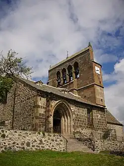 The church in Chalinargues | |
Location of Chalinargues | |
  Chalinargues Location within France  Chalinargues Location within Auvergne-Rhône-Alpes | |
| Coordinates: 45°09′21″N 2°55′59″E / 45.1558°N 2.9331°E | |
| Country | France |
| Region | Auvergne-Rhône-Alpes |
| Department | Cantal |
| Arrondissement | Saint-Flour |
| Canton | Murat |
Area 1 | 27.55 km2 (10.64 sq mi) |
| Population (2023)[1] | 304 |
| • Density | 11.0/km2 (28.6/sq mi) |
| Time zone | UTC+01:00 (CET) |
| • Summer (DST) | UTC+02:00 (CEST) |
| INSEE/Postal code | 15035 /15170 |
| Elevation | 909–1,169 m (2,982–3,835 ft) (avg. 1,060 m or 3,480 ft) |
| 1 French Land Register data, which excludes lakes, ponds, glaciers > 1 km2 (0.386 sq mi or 247 acres) and river estuaries. | |
Chalinargues (French pronunciation: [ʃalinaʁɡ]; Auvergnat: Chinargues) is a commune in the Cantal department in south-central France. Between December 2016 and January 2025, it was part of Neussargues en Pinatelle.[2][3]
Population
| Year | Pop. | ±% p.a. |
|---|---|---|
| 1968 | 635 | — |
| 1975 | 527 | −2.63% |
| 1982 | 440 | −2.54% |
| 1990 | 442 | +0.06% |
| 1999 | 433 | −0.23% |
| 2007 | 435 | +0.06% |
| 2012 | 426 | −0.42% |
| 2017 | 401 | −1.20% |
| 2023 | 304 | −4.51% |
| Source: INSEE[4] | ||
See also
References
- ↑ "Populations de référence 2023" (in French). National Institute of Statistics and Economic Studies. 18 December 2025.
- ↑ Arrêté préfectoral 21 September 2016 (in French)
- ↑ "Neussargues en Pinatelle : modification des limites territoriales de la commune". Les services de l'État dans le Cantal (in French). Retrieved 2025-01-03.
- ↑ Population municipale entre 1968 et 2023, INSEE

Wikimedia Commons has media related to Chalinargues.
