Villelongue-dels-Monts
Villelongue-dels-Monts
Vilallonga dels Monts | |
|---|---|
 A view within Villelongue-Dels-Monts | |
 Coat of arms | |
Location of Villelongue-dels-Monts | |
  Villelongue-dels-Monts Location within France  Villelongue-dels-Monts Location within Occitanie | |
| Coordinates: 42°31′35″N 2°54′15″E / 42.5264°N 2.9042°E | |
| Country | France |
| Region | Occitania |
| Department | Pyrénées-Orientales |
| Arrondissement | Céret |
| Canton | Vallespir-Albères |
| Intercommunality | CC des Albères, de la Côte Vermeille et de l'Illibéris |
| Government | |
| • Mayor (2020–2026) | Christian Nifosi[1] |
Area 1 | 11.55 km2 (4.46 sq mi) |
| Population (2023)[2] | 1,976 |
| • Density | 171.1/km2 (443.1/sq mi) |
| Time zone | UTC+01:00 (CET) |
| • Summer (DST) | UTC+02:00 (CEST) |
| INSEE/Postal code | 66225 /66740 |
| Elevation | 36–1,030 m (118–3,379 ft) (avg. 117 m or 384 ft) |
| 1 French Land Register data, which excludes lakes, ponds, glaciers > 1 km2 (0.386 sq mi or 247 acres) and river estuaries. | |
Villelongue-dels-Monts (French pronunciation: [vil.lɔ̃ɡ dɛls mɔ̃ts] ⓘ; Catalan: Vilallonga dels Monts) is a commune in the Pyrénées-Orientales department in southern France.[3]
The inhabitants are called Villelonguais.
Geography
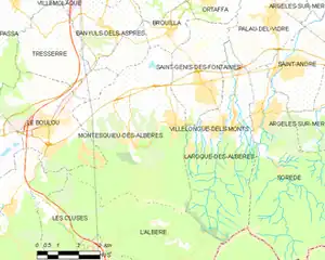
Villelongue-dels-Monts is located in the south of the department of Pyrénées-Orientales, 33 km south of Perpignan, 18 km east from the Mediterranean Sea and 17 km from the Spanish border by Le Perthus, in the canton of Vallespir-Albères and in the arrondissement of Céret.
Its close neighbouring communities are : in the north Banyuls-dels-Aspres, Brouilla and Saint-Génis-des-Fontaines; in the east Laroque-des-Albères; in the south l'Albère and in the west Montesquieu-des-Albères.
With a surface of 1155 hectares, the territory is narrow and long (2 km from east to west and 8 km from north to south).[4]
History
Villelongue-dels-Monts is named after the peak above the village which means « Villelongue-du-Mont ». It was mentioned for the first time in 981. Eventually, the monastery of Saint-Génis-des-Fontaines possessed a freehold on "Villalonga". The phrase "Castrum Sancti Christophori" appeared in 1095 to indicate the fortress constructed on the rocky peak.
Politics and administration
Mayors
|
|
Demography
The communal demography is marked by a certain stability between 1851 and 1975, fluctuating in a minimum of population of 408 in 1968 and a maximum of 533 in 1891, and alternating between the periods of growth and decline.
From the 1970s, Villelongue-dels-Monts began to grow rapidly, related to the growth of the metropolitan area of Perpignan.
Historical population | ||||||||||||||||||||||||||||||||||||||||||||||||||||||||||||||||||||||||||||||||||||||||||||||||||||||||||||||||||||||
|
| |||||||||||||||||||||||||||||||||||||||||||||||||||||||||||||||||||||||||||||||||||||||||||||||||||||||||||||||||||||
 | ||||||||||||||||||||||||||||||||||||||||||||||||||||||||||||||||||||||||||||||||||||||||||||||||||||||||||||||||||||||
| Source: EHESS[5] and INSEE (1968-2023)[6] | ||||||||||||||||||||||||||||||||||||||||||||||||||||||||||||||||||||||||||||||||||||||||||||||||||||||||||||||||||||||
Sites of interest
 Santa Maria del Vilar
 Église Saint-Étienne
See also
References
- ↑ "Répertoire national des élus: les maires". data.gouv.fr, Plateforme ouverte des données publiques françaises (in French). 2 December 2020.
- ↑ "Populations de référence 2023" (in French). National Institute of Statistics and Economic Studies. 18 December 2025.
- ↑ INSEE commune file
- ↑ Rapport de présentation - PLU de Villelongue dels Monts
- ↑ Des villages de Cassini aux communes d'aujourd'hui: Commune data sheet Villelongue-dels-Monts, EHESS (in French).
- ↑ Population municipale entre 1968 et 2023, INSEE
External links

