Syaphru
Syaphru
स्याफ्रु Syafru | |
|---|---|
Ward | |
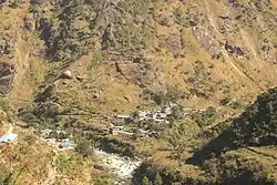 Syabrubesi in 2016 | |
  Syaphru Location in Bagmati Province, Nepal  Syaphru Syaphru (Nepal) | |
| Coordinates: 28°09′49″N 85°20′11″E / 28.1635°N 85.3363°E | |
| Country |  Nepal |
| Province | Bagmati Province |
| District | Rasuwa District |
| Rural municipality | Gosaikunda Rural Municipality |
| Ward | 5 |
| Population (2011)[1] | |
• Total | 2,271 |
| Former Syafru Village Development Committee | |
| Time zone | UTC+5:45 (Nepal Time) |
Syaphru (स्याफ्रु), spelled Syafru in Nepal's 2011 census, is Ward No. 5 of Gosaikunda Rural Municipality in Rasuwa District, Bagmati Province, Nepal.[2] Before Nepal's local-government restructuring, Syafru was a village development committee (VDC).[2]
The 2011 Nepal census recorded 2,271 people living in 621 households in the former Syafru VDC, including 1,172 males and 1,099 females.[1] Of the population, 1,844 were recorded as Tamang, making them the largest ethnic group in the former VDC.[1]
Syabrubesi is a settlement in the Syaphru area. A 2018 study in Food Security described Syabrubesi as a town situated within the former Syafru VDC.[3]
History

The Syaphru area has been identified with Xiebulu or Syapruk, the site of fighting during the second campaign of the Sino-Nepalese War in 1792. Historian Lucette Boulnois connected the place names recorded in Qing and Nepalese accounts with the area of modern Syaphru.[4]
According to the Weizangtongzhi, as discussed by Boulnois, Qing forces attacked the Gorkhali defensive position at Xiebulu around 23–24 July 1792. The Gorkhali forces subsequently withdrew further south towards Dhunche.[4]
Transport
Syabrubesi is an important road junction in northern Rasuwa.[3] The Pasang Lhamu Highway (NH18) connects Syabrubesi with Dhunche, Bidur and Kathmandu, and has its northern terminus at Syabrubesi.[5]
The Trishuli Corridor (NH42) also passes through the Syabrubesi area. The north–south highway continues towards Rasuwagadhi on the Nepal–China border, while its southern route follows the Trishuli River corridor through Mailung and Galchhi.[5]
The Department of Roads administers a dedicated Galchhi–Trishuli–Mailung–Syaphrubesi–Rasuwagadhi road project covering this section of the corridor.[6]
Syabrubesi is also a major trailhead for trekking in the Langtang region. The Nepal Tourism Board identifies it as one of the starting points of the Tamang Heritage Trail, which passes through settlements including Goljung, Gatlang, Chilime, Thuman, Timure and Briddim before returning towards Syabrubesi or joining routes into the Langtang Valley.[7]
2026 flood
On 26 August 2026, a major flash flood and debris-flow event struck northern Rasuwa District, severely affecting Syabrubesi, Timure and other settlements along the Bhote Koshi–Trishuli river corridor.[8] The flood damaged settlements, markets, roads, bridges and hydropower infrastructure.[8]
The Copernicus Emergency Management Service classified the event in its rapid-mapping dataset as a flash flood triggered by a glacial lake outburst flood on the Bhote Koshi.[9]
Copernicus satellite mapping delineated approximately 111 hectares (270 acres) of mass movement in its Syapru Besi assessment area. Of 559 mapped buildings there, 433 were classified as affected. Across the Syapru Besi and Timure assessment areas, six bridges, a helipad and approximately 9.5 kilometres (5.9 mi) of primary road, including part of the Pasang Lhamu Highway, were classified as destroyed.[9] The assessment was based on post-event satellite imagery acquired on 27 August and was produced as an emergency rapid-mapping product; it had not yet been validated by a field survey.[9]
The flood also directly affected local administration. The offices of Gosaikunda Rural Municipality and Ward No. 5 in Syabrubesi were reported to have been swept away, while road, electricity and telephone connections were disrupted. Municipal officials subsequently prepared to conduct administrative work from Dhunche.[10]
References
- 1 2 3 "National Population and Housing Census 2011: Rasuwa VDC Level Report" (PDF). Central Bureau of Statistics, Government of Nepal. Retrieved 31 August 2026.
- 1 2 "परिचय" [Introduction] (in Nepali). Gosaikunda Rural Municipality. Retrieved 31 August 2026.
- 1 2 Merrey, Douglas James; Hussain, Abid; Tamang, Deepak Dorje; Thapa, Bhuwan; Prakash, Anjal (23 July 2018). "Evolving high altitude livelihoods and climate change: a study from Rasuwa District, Nepal". Food Security. 10: 1055–1071. doi:10.1007/s12571-018-0827-y.
- 1 2 Boulnois, Lucette (1989). "Chinese Maps and Prints on the Tibet-Gorkha War of 1788–92". Kailash: A Journal of Himalayan Studies. 15 (1–2): 85–112. Retrieved 31 August 2026.
- 1 2 "Statistics of National Highways [SNH], 2022–023". Department of Roads, Government of Nepal. 14 July 2024. Retrieved 31 August 2026.
- ↑ "गल्छी त्रिशुली मैलुङ स्याफ्रुवेशी रसुवागढी सडक योजना" [Galchhi–Trishuli–Mailung–Syaphrubesi–Rasuwagadhi Road Project] (in Nepali). Department of Roads, Government of Nepal. Retrieved 31 August 2026.
- ↑ "Langtang Region". Nepal Tourism Board. Retrieved 31 August 2026.
- 1 2 "Flash flood hits Rasuwa, damages hydropower projects and markets". The Kathmandu Post. 26 August 2026. Retrieved 31 August 2026.
- 1 2 3 "Flood and mass movement damage grading, Syapru Besi and Timure, Rasuwa District, Nepal (27 August 2026) – Copernicus EMS EMSR927". UNESCO IHP Water Information Network System. European Commission, Joint Research Centre. 28 August 2026. doi:10.63253/bkdj361r. Retrieved 31 August 2026.
- ↑ BC, Ganga (29 August 2026). "Floods wipe out local governments' ability to lead rescue, relief". The Kathmandu Post. Retrieved 31 August 2026.
