St. Isidore, Ontario
St. Isidore | |
|---|---|
Unincorporated community | |
 | |
  St. Isidore Location within Southern Ontario | |
| Coordinates: 45°23′06″N 74°54′20″W / 45.38500°N 74.90556°W | |
| Country | Canada |
| Province | Ontario |
| County | Prescott and Russell |
| Municipality | The Nation |
| Settled | 1845 |
| Incorporated | 1965 |
| Dissolved (amalgamated) | January 1, 1998 |
| Government | |
| • Fed. riding | Prescott—Russell—Cumberland |
| • Prov. riding | Glengarry—Prescott—Russell |
| Area | |
| • Land | 1.17 km2 (0.45 sq mi) |
| Population (2021)[1] | |
• Total | 892 |
| • Density | 763.4/km2 (1,977/sq mi) |
| Time zone | UTC-5 (EST) |
| • Summer (DST) | UTC-4 (EDT) |
| Postal code | K0C 2B0 |
| Area codes | 613, 343 |
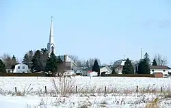
St. Isidore (formerly known as St. Isidore de Prescott) is a community in The Nation Municipality in the United Counties of Prescott and Russell in Ontario, Canada. A designated place, St. Isidore had a population of 892 in the 2021 Canadian census.[1]
The town was originally called St. Isidore de Prescott, but in 1989, the name was shortened to St. Isidore.[2] The community became an incorporated village in 1965 when it separated from Caledonia and South Plantagenet Township.[3] However, the incorporated village was short-lived and became part of The Nation Municipality on January 1, 1998, along with the Townships of Caledonia, Cambridge, and South Plantagenet.[4]
St-Isidore has a French elementary school (Kindergarten to 6) called L'école Catholique de St-Isidore . The school has between 200 and 300 students.
A 24 megawatt solar power plant is located near the town.
The St-Isidore Catholic Church, built in 1879 was destroyed by fire on July 23, 2016.[5]
Demographics

In the 2021 Census of Population conducted by Statistics Canada, St. Isidore had a population of 892 living in 370 of its 385 total private dwellings, a change of 10.8% from its 2016 population of 805. With a land area of 1.17 km2 (0.45 sq mi), it had a population density of 762.4/km2 (1,974.6/sq mi) in 2021.[1]
Statistics from 2011 census:[6]
- Population in 2011: 752
- Total private dwellings: 330
- Land area (square km): 1.15
- Population density per square km: 652.4
- Median age of the population: 45.1
- Total number of occupied private dwellings by structural type of dwelling: 315
- Single-detached house: 225
- Other dwelling: 15
- Apartment, duplex: 10
- Apartment, building that has fewer than five storeys: 55
| Mother tongue (2021)[1] | Population | Percentage |
|---|---|---|
| English | 190 | 22.2% |
| French | 610 | 71.3% |
| English and French | 25 | 2.9% |
Historical census populations – St. Isidore (Village 1965–1997, Designated place 1998–...) | |||||||||||||||||||||||||||||||||||||||||||
|
| ||||||||||||||||||||||||||||||||||||||||||
| Population counts are not adjusted for boundary changes. Source: Statistics Canada[1][3][6] | |||||||||||||||||||||||||||||||||||||||||||
Notable people
- Royal Galipeau - politician
- Valérie Grenier - Canadian alpine ski racer who competed in the 2018, 2022, and 2026 Winter Olympics
- Benoît Pouliot - professional ice hockey player
- Francis Wathier - professional ice hockey player
References
- 1 2 3 4 5 6 "St. Isidore, Dissolved municipality (DMU), Ontario [Designated place] Census Profile, 2021 Census of Population". www12.statcan.gc.ca. Government of Canada - Statistics Canada. Retrieved 2026-07-29.
- ↑ Place names of Ontario, page 302, Alan Rayburn (1997) ISBN 0-8020-7207-0
- 1 2 "1971 Census of Canada - Population Census Subdivisions (Historical)". Catalogue 92-702 Vol I, part 1 (Bulletin 1.1-2). Statistics Canada. July 1973.
- ↑ "Municipal restructuring activity summary table - Dataset - Ontario Data Catalogue". data.ontario.ca. Government of Ontario. Retrieved 1 July 2026.
- ↑ "Press Release – The St-Isidore Church Is Engulfed in Flames". La municipalité de la Nation Municipality. 20 August 2016. Archived from the original on 2016-08-20.
- 1 2 "St. Isidore, DMU, Ontario (Designated place) Census Profile, 2011 Census of Population". www12.statcan.gc.ca. Government of Canada - Statistics Canada. Retrieved 2026-07-29.
External links
 Media related to St. Isidore, Ontario at Wikimedia Commons