Sand Bridge State Park
| Sand Bridge State Park | |
|---|---|
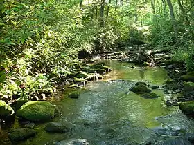 Rapid Run | |
  Location within Pennsylvania  Location within the United States | |
Interactive map of Sand Bridge State Park | |
| Location | Lewis Township, Union County, Pennsylvania, United States |
| Coordinates | 40°59′14″N 77°07′36″W / 40.9872°N 77.12665°W[1] |
| Area | 3 acres (1.2 ha)[2] |
| Elevation | 1,572 feet (479 m) |
| Established | 1978 |
| Administrator | Pennsylvania Department of Conservation and Natural Resources |
| Website | Official website  |
| Pennsylvania State Parks | |
Sand Bridge State Park is a Pennsylvania state park on 3 acres (0.01 km2) in Lewis Township, Union County, Pennsylvania in the United States. The park is the smallest state park in Pennsylvania and consists of a picnic area just off Pennsylvania Route 192. It has three picnic pavilions that were built by the Civilian Conservation Corps during the Great Depression. Rapid Run, a trout stream that is stocked by the Pennsylvania Fish and Boat Commission, flows through Sand Bridge State Park. The park attracted 17,000 visitors in 2008.[3] The name Sand Bridge remains a mystery. No one, according to the parks official website knows why the area is known as Sand Bridge. The park is surrounded by Bald Eagle State Forest and became a Pennsylvania State park in 1978.[1]
References
- 1 2 "Sand Bridge State Park". Pennsylvania Department of Conservation and Natural Resources. Retrieved January 18, 2026.
- ↑ Forrey, William C. (2017). "History of Pennsylvania's State Parks 1984 to 2015" (PDF). Pennsylvania Department of Conservation and Natural Resources. p. 73. Retrieved January 18, 2026.
- ↑ Laeplle, Wayne (May 30, 2009). "State's budget idea baffles Valley anglers, campers". The Daily Item. Retrieved September 14, 2010.
External links

- Sand Bridge State Park Pennsylvania Department of Conservation and Natural Resources
- "Sand Bridge State Park official map" (PDF). Archived from the original (PDF) on November 15, 2012. (123.6 KB)
