Rolleston, Queensland
Rolleston | |||||||||||||
|---|---|---|---|---|---|---|---|---|---|---|---|---|---|
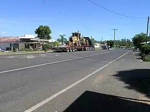 The main street of Rolleston | |||||||||||||
  Rolleston | |||||||||||||
Interactive map of Rolleston | |||||||||||||
| Coordinates: 24°27′47″S 148°37′25″E / 24.4630°S 148.6236°E | |||||||||||||
| Country | Australia | ||||||||||||
| State | Queensland | ||||||||||||
| LGA | |||||||||||||
| Location |
| ||||||||||||
| Government | |||||||||||||
| • State electorate | |||||||||||||
| • Federal division | |||||||||||||
| Area | |||||||||||||
• Total | 140.1 km2 (54.1 sq mi) | ||||||||||||
| Population | |||||||||||||
| • Total | 132 (2021 census)[1] | ||||||||||||
| • Density | 0.942/km2 (2.440/sq mi) | ||||||||||||
| Time zone | UTC+10:00 (AEST) | ||||||||||||
| Postcode | 4702 | ||||||||||||
| Mean max temp | 29.5 °C (85.1 °F) | ||||||||||||
| Mean min temp | 14.1 °C (57.4 °F) | ||||||||||||
| Annual rainfall | 635 mm (25.0 in) | ||||||||||||
| |||||||||||||
Rolleston is a rural town and locality in the Central Highlands Region, Queensland, Australia.[2][3] In the 2021 census, the locality of Rolleston had a population of 132 people.[1]
Geography

Rolleston is located on the Comet River, 335 kilometres (208 mi) west of Gladstone, 263 kilometres (163 mi) north of Roma and 694 kilometres (431 mi) northwest of Brisbane. Springsure, the nearest town, lies 71 kilometres (44 mi) to the north-west. Rolleston is at the junction of the Carnarvon and Dawson highways.[4]
There is a large coal mine 13 kilometres (8.1 mi) to the west called the Rolleston coal mine.[5]
Climate
| Climate data for Rolleston Airport (1991–2020) | |||||||||||||
|---|---|---|---|---|---|---|---|---|---|---|---|---|---|
| Month | Jan | Feb | Mar | Apr | May | Jun | Jul | Aug | Sep | Oct | Nov | Dec | Year |
| Record high °C (°F) | 44.5 (112.1) |
43.2 (109.8) |
41.2 (106.2) |
37.0 (98.6) |
34.5 (94.1) |
31.4 (88.5) |
30.8 (87.4) |
35.4 (95.7) |
40.7 (105.3) |
41.6 (106.9) |
43.0 (109.4) |
44.0 (111.2) |
44.5 (112.1) |
| Mean daily maximum °C (°F) | 34.8 (94.6) |
33.7 (92.7) |
32.7 (90.9) |
29.8 (85.6) |
26.0 (78.8) |
23.0 (73.4) |
22.9 (73.2) |
25.1 (77.2) |
28.6 (83.5) |
31.3 (88.3) |
33.2 (91.8) |
34.4 (93.9) |
29.6 (85.3) |
| Daily mean °C (°F) | 28.0 (82.4) |
27.3 (81.1) |
25.7 (78.3) |
22.2 (72.0) |
18.2 (64.8) |
15.2 (59.4) |
14.4 (57.9) |
16.0 (60.8) |
19.7 (67.5) |
23.0 (73.4) |
25.6 (78.1) |
27.2 (81.0) |
21.9 (71.4) |
| Mean daily minimum °C (°F) | 21.3 (70.3) |
20.9 (69.6) |
18.8 (65.8) |
14.6 (58.3) |
10.4 (50.7) |
7.5 (45.5) |
5.9 (42.6) |
6.9 (44.4) |
10.8 (51.4) |
14.8 (58.6) |
18.0 (64.4) |
20.0 (68.0) |
14.1 (57.4) |
| Record low °C (°F) | 14.5 (58.1) |
11.9 (53.4) |
9.5 (49.1) |
2.9 (37.2) |
−1.0 (30.2) |
−1.5 (29.3) |
−3.0 (26.6) |
−3.0 (26.6) |
0.5 (32.9) |
4.5 (40.1) |
7.2 (45.0) |
8.9 (48.0) |
−3.0 (26.6) |
| Average precipitation mm (inches) | 89.1 (3.51) |
97.1 (3.82) |
53.9 (2.12) |
34.2 (1.35) |
25.4 (1.00) |
33.6 (1.32) |
15.2 (0.60) |
20.6 (0.81) |
31.2 (1.23) |
47.4 (1.87) |
57.1 (2.25) |
85.3 (3.36) |
590.1 (23.23) |
| Average precipitation days (≥ 1 mm) | 6.7 | 5.9 | 4.1 | 2.8 | 2.3 | 2.9 | 1.7 | 1.9 | 2.8 | 4.8 | 5.2 | 6.6 | 47.6 |
| Source: National Oceanic and Atmospheric Administration[6] | |||||||||||||
History
First Nations
Rolleston was built on Kanolu land. The Kanolu language group encompasses Rolleston.[7]
Wadja is also an Australian Aboriginal language in Central Queensland. The language region includes the local government areas of the Aboriginal Shire of Woorabinda and Central Highlands Region, including the Blackdown Tablelands. the Comet River, and the Expedition Range, and the towns of Woorabinda, Springsure and Rolleston.[8]
European exploration
Ludwig Leichhardt's 1844 expedition through the region marked the first entry of Europeans. Leichhardt named the area "Brown's Lagoon" after Harry Brown, an Indigenous Awabakal guide from Newcastle who was employed on the expedition. They found many huts built by the Kanolu around the lagoon indicating the vicinity was well populated.[9]
The township of Rolleston
The township was first called Brown's Lagoon and then Brown Town[10][11] before being named Rolleston after Christopher Rolleston, a pastoralist who was involved in leasing a number of pastoral runs in the area in the 1860s.[2][3]
Rolleston State School opened on 9 October 1871.[12]
Queensland's last legendary cattle thieves and bushrangers, the notorious Patrick and James Kenniff, frequently lived at Lethbridge Pocket, which is now within Carnarvon National Park. It was here on Easter Sunday, 30 March 1902, that they murdered Constable George Doyle and cattle station manager Albert Dahlke.[13]
All Saints Anglican Church was officially opened on Sunday 10 June 1934 by Bishop Fortescue Ash.[14][15]
Mining began at the Rollestone coal mine in October 2005 and is expected to last more than 20 years.[5]
Demographics
In the 2006 census, the locality of Rolleston had a population of 217 people.[16]
In the 2011 census, the locality of Rolleston had a population of 129 people.[17]
In the 2016 census, the locality of Rolleston had a population of 309 people.[18]
In the 2021 census, the locality of Rolleston had a population of 132 people.[1]
Education

Rolleston State School is a government primary (Prep-6) school for boys and girls at 16 Warrijo Street (24°27′45″S 148°37′26″E / 24.4624°S 148.6240°E).[19][20][21] In 2018, the school had an enrolment of 63 students with 6 teachers (4 full-time equivalent) and 7 non-teaching staff (3 full-time equivalent).[22]
There are no secondary schools in Rolleston or nearby. The nearest government schools offering secondary education are Springsure State School (to Year 10) in Springsure to the north-west and Emerald State High School (to Year 12) in Emerald to the north. Distance education and boarding schools are options.[23]
Amenities
The Central Highlands Regional Council operates a public library on Planet Street.[24]

There are two churches in Rolleston:
- All Saints' Anglican Church, 2 Warrijo Street (24°27′42″S 148°37′31″E / 24.4617°S 148.6253°E)[25]
- St Theresa's Catholic Church, 28 Orion Street (24°27′58″S 148°37′32″E / 24.4661°S 148.6255°E)[26]
Facilities
Emergency services available in Rolleston include:
- Rolleston Police Station (24°27′47″S 148°37′14″E / 24.4630°S 148.6206°E)[27]
- Rolleston Fire Station (24°27′41″S 148°37′22″E / 24.4614°S 148.6229°E)[27]
- Rolleston SES Facility (24°27′50″S 148°37′36″E / 24.4638°S 148.6267°E)[27]
See also

References
- 1 2 3 Australian Bureau of Statistics (28 June 2022). "Rolleston (SAL)". 2021 Census QuickStats. Retrieved 28 February 2023.
- 1 2 "Rolleston – town in Central Highlands Region (entry 28948)". Queensland Place Names. Queensland Government. Retrieved 13 February 2022.
- 1 2 "Rolleston – locality in Central Highlands Region (entry 46975)". Queensland Place Names. Queensland Government. Retrieved 13 February 2022.
- ↑ "Layers: Locality; Road and rail; Railways; Railway stations". Queensland Globe. Queensland Government. Retrieved 6 January 2026.
- 1 2 Department of Infrastructure and Planning. "Rolleston Coal Project". Government of Queensland. Archived from the original on 29 June 2009. Retrieved 30 June 2009.
- ↑ "Rolleston Airport Climate Normals for 1991-2020" (CSV). National Oceanic and Atmospheric Administration. Retrieved 1 March 2025.
- ↑ "Kanolu (QLD)". South Australian Museum. Retrieved 6 January 2026.
- ↑
 This Wikipedia article incorporates CC BY 4.0 licensed text from: "Wadja". Queensland Aboriginal and Torres Strait Islander languages map. State Library of Queensland. Retrieved 5 February 2020.
- ↑ Leichhardt, Ludwig (1847). Journal of an Overland Expedition in Australia from Moreton Bay to Port Essington. London: T & W Boone.
- ↑ "OUR HISTORY". The Morning Bulletin. No. 26, 916. Queensland, Australia. 26 September 1947. p. 12. Retrieved 15 August 2026 – via National Library of Australia.
- ↑ "HISTORY IN PLACE NAMES". The Morning Bulletin. No. 27, 642. Queensland, Australia. 2 February 1950. p. 7. Retrieved 15 August 2026 – via National Library of Australia.
- ↑ "Opening and closing dates of Queensland Schools". Queensland Government. Retrieved 18 April 2019.
- ↑ "George Doyle". Police Memorial. Queensland Police. Archived from the original on 12 April 2021. Retrieved 23 February 2022.
- ↑ "ALL SAINTS'". Morning Bulletin. No. 21, 183. Queensland, Australia. 15 June 1934. p. 12. Archived from the original on 24 February 2022. Retrieved 24 February 2022 – via National Library of Australia.
- ↑ "NEW ROLLESTON CHURCH". The Central Queensland Herald. Vol. 6, no. 234. Queensland, Australia. 21 June 1934. p. 55. Archived from the original on 24 February 2022. Retrieved 24 February 2022 – via National Library of Australia.
- ↑ Australian Bureau of Statistics (25 October 2007). "Rollestone (SSC)". 2006 Census QuickStats. Retrieved 24 February 2022.
- ↑ Australian Bureau of Statistics (31 October 2012). "Rolleston (SSC)". 2011 Census QuickStats. Retrieved 10 March 2017.
- ↑ Australian Bureau of Statistics (27 June 2017). "Rolleston (SSC)". 2016 Census QuickStats. Retrieved 20 October 2018.
- ↑ "State and non-state school details". Queensland Government. 9 July 2018. Archived from the original on 21 November 2018. Retrieved 21 November 2018.
- ↑ "Rolleston State School". Rolleston State School. 29 November 2020. Retrieved 14 February 2025.
- ↑ "Rolleston State School". Archived from the original on 1 August 2012. Retrieved 21 November 2018.
- ↑ "ACARA School Profile 2018". Australian Curriculum, Assessment and Reporting Authority. Archived from the original on 27 August 2020. Retrieved 28 January 2020.
- ↑ "Queensland Globe". State of Queensland. Retrieved 24 February 2022.
- ↑ "Rolleston Library". Public Libraries Connect. State Library of Queensland. 31 March 2017. Archived from the original on 29 January 2018. Retrieved 29 January 2018.
- ↑ "Anglican Parish of Springsure". anglicanchurchcq.org.au. Archived from the original on 3 March 2021. Retrieved 24 February 2022.
- ↑ "Springsure". Roman Catholic Diocese of Rockhampton. Archived from the original on 6 December 2021. Retrieved 24 February 2022.
- 1 2 3 "Emergency services facilities - Queensland". Queensland Open Data. Queensland Government. 18 November 2020. Archived from the original on 24 November 2020. Retrieved 24 November 2020.
External links

