Rio Vermelho
Rio Vermelho | |
|---|---|
| Municipality of Rio Vermelho | |
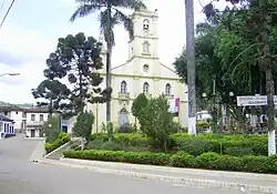 | |
 Flag  Coat of arms | |
 Location in Minas Gerais | |
| Country |  Brazil |
| State |  Minas Gerais |
| Region | Southeast |
| Intermediate Region | Governador Valadares |
| Immediate Region | Guanhães |
| Founded | 31 January 1938 |
| Government | |
| • Mayor | Marcus Vinicius Dayrell de Oliveira (PSD) |
| Area | |
• Total | 986.561 km2 (380.913 sq mi) |
| [1] | |
| Elevation | 831 m (2,726 ft) |
| Population | |
• Total | 12,641 |
| 12,770 | |
| Demonym | rio-vermelhense |
| Time zone | UTC−3 (BRT) |
| Postal Code | 39170-000 to 39179-999 |
| HDI (2010) | 0.558 – medium[4] |
| Website | riovermelho |
Rio Vermelho is a Brazilian municipality located in the state of Minas Gerais. The city belongs to the mesoregion Metropolitana de Belo Horizonte and to the microregion of Conceição do Mato Dentro. As of 2025, the estimated population was 12,770.[3]
See also
References
- ↑ "IBGE Rio Vermelho". IBGE. Retrieved 29 May 2023.
- ↑ "Município de Rio Vermelho". cidade-Brasil. Retrieved 29 May 2023.
- 1 2 3 Brazilian Institute of Geography and Statistics (IBGE). "IBGE 2025".
- ↑ "Archived copy" (PDF). United Nations Development Programme (UNDP). Archived from the original (PDF) on 8 July 2014. Retrieved 13 March 2022.
{{cite web}}: CS1 maint: archived copy as title (link)
18°17′38″S 43°00′32″W / 18.29389°S 43.00889°W
