Municipio VIII
Municipio VIII di Roma | |
|---|---|
Municipio of Rome | |
 Location of Municipio VIII of Rome | |
| Country | Italy |
| Region | Lazio |
| Comune | Rome |
| Established | 19 January 2001 11 March 2013 (renamed) |
| Government | |
| • President | Amedeo Ciaccheri (SI) |
| Area | |
• Total | 1,826 sq mi (4,729 km2) |
| Population (2023) | |
• Total | 130,089 |
| • Density | 7,184.1/sq mi (2,773.79/km2) |
| Time zone | UTC+1 (CET) |
| • Summer (DST) | UTC+2 (CEST) |
| Website | Municipio VIII of Rome |
Municipio VIII is one of the 15 administrative subdivisions of the city of Rome, Italy.[1]
It was first created by Rome's City Council on 19 January 2001 as Municipio XI and features a president who is elected during the mayoral elections. On 11 March 2013, following a municipal reorganization, its designation was officially changed to Municipio VIII.[2]
Subdivision
Municipio VIII is divided into 9 urban zones:
| Urban zone |
Population |  |
| 11A. Ostiense |
7,673 | |
| 11B. Valco San Paolo |
7,488 | |
| 11C. Garbatella |
43,601 | |
| 11D. Navigatori |
5,124 | |
| 11E. Tor Marancia |
33,026 | |
| 11F. Tre Fontane |
11,836 | |
| 11G. Grottaperfetta |
15,636 | |
| 11X. Appia Antica North |
2,641 | |
| 11Y. Appia Antica South |
755 | |
| Not localized |
2,309 | |
| Total | 130,089 |
Municipal Government
The area has its own local authority called Consiglio di Municipio (Municipal Council), composed by a president and 25 members directly elected by citizens every five years. The council is responsible for most local services, such as schools, social services, waste collection, roads, parks, libraries and local commerce in the area, and manages funds (if any) provided by the city government for specific purposes, such as those intended to guarantee the right to education for poorer families.
The current president is Amedeo Ciaccheri (SI). He was elected in the 2021 Rome municipal election together with the 25-member Municipal Council, whose composition is shown below:
| Alliance or political party |
Members | ||
|---|---|---|---|
| 2021–2027 | |||
| Centre-left (PD-SI) |
16 | 16 / 25 | |
| Brothers of Italy (FdI) | 5 | 5 / 25 | |
| Action (A) | 2 | 2 / 25 | |
| Five Star Movement (M5S) | 2 | 2 / 25 | |
Here is a list of presidents of the Municipio VIII since 2001:
| President | Party | Coalition | Term of office | ||
|---|---|---|---|---|---|
| Massimiliano Smeriglio | PRC | Centre-left | 30 May 2001 | 30 May 2006 | |
| Andrea Catarci | PRC/SEL | Centre-left | 30 May 2006 | 20 June 2016 | |
| Paolo Pace | M5S | 20 June 2016 | 10 April 2017[a] | ||
| Special Commissioner (2017–2018) | |||||
| Amedeo Ciaccheri | SI | Centre-left | 10 June 2018 | Incumbent | |
- ↑ Resigned.
Geography


The territory of Municipio VIII extends across the southern quadrant of Rome, covering an area of 47.23 square kilometers and acting as a transition zone between the city's historic center and its southern suburban expansion.[3] Its geographical boundaries are defined by a mix of natural elements, ancient infrastructure, and modern transport lines. To the north, the boundary is marked by the Aurelian Walls near Porta San Paolo and Piazzale Ostiense, separating the district from Municipio I.[4] The western border is naturally formed by the urban course of the Tiber, which divides Municipio VIII from Municipio XI, running along the Marconi and Ostiense districts.[5] To the east, the boundary follows the valley of the Caffarella Park and the initial stretch of the Via Appia Antica, bordering Municipio VII.[6] Topographically, the landscape is characterized by the low alluvial plains near the riverbanks and the typical Roman tuff hills, such as those hosting the historic garden-city of Garbatella, alongside heavily urbanized areas like San Paolo and Montagnola, and vast protected green zones like Tor Marancia.[7]
Ostiense
The Ostiense district is located in the northern area of Municipio VIII, positioned immediately outside the ancient city walls of Rome.[8] Topographically, the district occupies a flat alluvial valley formed by the slow loop of the Tiber, a geographical element that historically favored its development as an industrial and logistical hub for the capital.[9] The boundaries of Ostiense are strictly defined by both natural and man-made infrastructure. To the north, the quarter is separated from the historic center (rione Testaccio and rione San Saba) by the layout of the Aurelian Walls, stretching between Porta San Paolo and the Campo Boario area.[10] Its western border is entirely formed by the path of the Tiber, which separates Ostiense from the Portuense and Gianicolense quarters, while its southern limit extends down to Via delle Sette Chiese and the massive complex of the Basilica of Saint Paul Outside the Walls.[11] To the east, the district's boundary runs along the historical route of the Via Ostiense and the Rome-Lido railway line, which divides it from the neighboring Garbatella and Tor Marancia areas, creating a highly interconnected urban corridor.[12]
Garbatella
Garbatella represents one of the most distinctive urban anomalies in Rome, dualistic in its classification as both a historic neighborhood and an official administrative entity.[13] Geographically, it is located within the northern section of Municipio VIII, sitting on a system of rolling tuff hills adjacent to the Basilica of Saint Paul Outside the Walls.[14] While the layperson colloquially refers to it as a "quartiere," it legally constitutes Urban Zone 11C and sits entirely inside the broader, official limits of the Ostiense district.[15]
The physical boundaries of Garbatella are carved out by massive infrastructural barriers and historical thoroughfares. Its western perimeter is bounded by the route of the Via Ostiense and the parallel Rome-Lido railway line, which isolates the neighborhood from the heavy industrial docks of the Tiber River.[16] To the east, the neighborhood is strictly framed by the massive transit corridor of Via Cristoforo Colombo, which separates it from the Appia Antica system and the Tor Marancia zone.[17] Its northern frontier is defined by the Circonvallazione Ostiense and the Settimia Spizzichino bridge, while the southern boundary tapers off along the ancient pilgrimage route of Via delle Sette Chiese.[18] This precise insulation allowed the core area to develop its iconic, insular "Garden City" layout—consisting of private, low-rise architectural blocks or "lotti" grouped around shared courtyards—which stands in stark contrast to the surrounding dense, high-rise urban expansion.[19]
The historical origin of Garbatella is deeply connected to the industrial development of Rome during the early twentieth century, specifically linked to the construction of the river port in the adjacent Ostiense district.[20] On 18 February 1920, King Victor Emmanuel III laid the foundation stone at Piazza Benedetto Brin, officially initiating a project spearheaded by the Istituto Case Popolari (ICP) under the guidance of Alberto Calza Bini.[21] The initial societal objective was to provide affordable, decent housing for the working-class families employed in the nearby maritime harbor and factories, drawing inspiration from Ebenezer Howard's British "Garden City" movement.[22] However, the demographic nature of the neighborhood shifted dramatically following the Fascist regime's urban demolitions in the historic center of Rome during the late 1920s; the newly displaced families from rioni like Borgo and Monti were mass-relocated to Garbatella, forcing the sudden construction of large-scale collective housing blocks, such as the iconic "Alberghi Suburbani" (Suburban Hotels).[23]
From an architectural standpoint, Garbatella serves as an open-air museum for the "Barocchetto Romano," a unique stylistic compromise engineered by prominent architects and urban planners of the era, including Gustavo Giovannoni, Innocenzo Sabbatini, and Costantino Costantini.[24] This style rejected the cold, monotonous geometry of traditional working-class tenements, opting instead for low-rise, organic residential units known as "lotti" that harmonized with the natural curves of the tuff hills.[17] The buildings feature an eclectic mix of elements borrowed from Roman Renaissance, Baroque, and medieval vernacular traditions, utilizing affordable yet highly decorative plasterwork, friezes, stuccoes, and whimsical moldings representing local flora and fauna.[15] The core layout is centered around shared, semi-private inner courtyards and public gardens, which were designed not only to maximize natural light and ventilation but also to deliberately foster a tight-knit communal lifestyle among the residents, a social fabric that remains exceptionally vibrant to this day.[25]
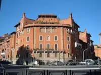 Suburban Hotel in Garbatella
 The Lovers' Staircase
 Public square and Suburban Hotel in Garbatella
 Palladium Theatre
 Typical street art in Garbatella
Appia Antica

The easternmost boundary of Municipio VIII is defined by the initial stretch of the Via Appia Antica, historically renowned as the "Regina Viarum" (Queen of Roads), which was originally laid out in 312 BC by the censor Appius Claudius Caecus.[26] Within the context of modern municipal geography, this ancient infrastructural axis separates the urban zones of Municipio VIII from the dense residential quarters of Municipio VII, acting as a protected green buffer and a monumental open-air museum.[8] Topographically, the road runs parallel to the alluvial valley of the Caffarella, traversing a landscape dominated by volcanic pozzolana and tuff formations deposited by the ancient Latium Volcano.[27]
This specific municipal sector contains an extraordinary density of archaeological and sepulchral monuments that reflect the ancient Roman law prohibiting burials within the city walls. Near the northern apex, where the road originates close to the Aurelian Walls and Porta San Sebastiano, lies the complex of the Catacombs of Saint Callixtus, a massive underground cemetery network that serves as the official burial site for early popes.[28] Moving further south along the municipal border, the ancient paved stones lead to the monumental complex of Maxentius, which encompasses the imperial palace, the remarkably preserved Circus of Maxentius, and the dynastic Mausoleum of Romulus.[29] Immediately adjacent to this complex stands the iconic Tomb of Caecilia Metella, a circular concrete and travertine mausoleum that was later transformed into a medieval fortified castle (the Caetani Castrum), showcasing how the physical geography of the Appia Antica shifted from a sacred funerary highway to a strategic military bottleneck guarding the southern access to Rome.
Education
Higher Education

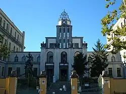
The territory of Municipio VIII hosts a dense concentration of high schools and public university facilities.[30] One of the universities in the area is the Roma Tre University (Università degli Studi Roma Tre), which was founded in 1992.[31]
Culture
Public Libraries
The public library network within Municipio VIII provides essential cultural services, research facilities, and community spaces.
- Biblioteca Joyce-Lussu – Located in the San Paolo area near Villa Certosa, this library specializes in modern literature, gender studies, and intercultural projects, offering large reading rooms and hosting frequent public book presentations.[32]
- Biblioteca Hub Culturale Garbatella – Situated within the historic core of the Garbatella garden-city, this innovative space combines traditional lending services with digital co-working areas, focusing heavily on local history, urban planning archives, and civic community workshops.[33]
- Biblioteca Area Umanistica (Roma Tre) – While primarily a university infrastructure located along Via Ostiense, this academic library opens its consultation spaces to the local public.[34]
Museums

Centrale Montemartini

The Centrale Montemartini is located along Via Ostiense. The complex originally opened in 1912 as Rome's very first public thermoelectric power plant, named after Giovanni Montemartini, an economist and theorist of municipal public services.[35]
The building's architectural fate changed dramatically in 1997, when it was selected to temporarily host a massive collection of ancient Roman sculptures during the structural renovation of the main Capitoline complexes on the Capitoline Hill.[36] The collection would later be permanently hosted in the building.
Transport
Stations of Rome Metro in the Municipio VIII are:

Stations of Lazio regional railways in the Municipio II are:


Other major infrastructures are:
- Roma Ostiense railway station – It serves as one of the largest railway station in Rome.
Public parks

The territory of Municipio VIII features an exceptional wealth of green spaces, acting as one of the primary ecological lungs of Rome by blending vast natural landscapes with protected archaeological environments.[37] While the broader regional reserve of the Appian Way connects this area to neighboring districts—including the famous Parco degli Acquedotti which sits entirely further east within the borders of Municipio VII—the green infrastructure within the strict administrative boundaries of Municipio VIII provides vital regional biodiversity sanctuaries.[38]
- Parco della Caffarella – Sprawling across the eastern border, this massive alluvial valley represents one of the largest urban parks in Europe, containing functioning historic farms, the Almone river, and unique wildlife habitats alongside Roman ruins.[39]
- Tenuta di Tor Marancia – This protected area covers over 200 hectares of raw Roman countryside inside the city, featuring dense oak woodlands, ancient Roman villas, and natural valleys that were saved from building speculation through public preservation movements.[40]
- Parco di Commodilla – Located in the heart of the San Paolo district, this urban park serves as an essential neighborhood garden and rests directly on top of the ancient Catacombs of Commodilla, blending daily community recreation with underground historical heritage.[41]
- Parco Schuster – Situated immediately adjacent to the Basilica of Saint Paul Outside the Walls, this large lawned park serves as a highly popular social gathering spot for university students and families, hosting cultural events, concerts, and local civilian memorials.[42]
Gallery
 Business Centre in Appio-Latino
 Seat of Regional Government of Lazio
 Ardeatine massacre monument
 Ostiense post office

References
- ↑ "Roma Capitale". Roma Capitale (in Italian). Retrieved 14 August 2026.
{{cite web}}: Text "Municipi" ignored (help); Text "Sito Istituzionale" ignored (help) - ↑ "Roma, sì all'accorpamento dei municipi: il Consiglio li riduce da 19 a 15". Il Messaggero. 11 March 2013. Retrieved 13 March 2013.
- ↑ For official administrative data and land extension, see the Roma Capitale Portal for Municipio VIII.
- ↑ The historical urban demarcations are mapped in the ISTAT territorial breakdowns for Rome, accessible via ISTAT Administrative Boundaries.
- ↑ The relationship between the river valley and the urban layout is detailed by the Lazio Regional Environment Authority.
- ↑ Environmental and park limits are documented by the Parco Regionale dell'Appia Antica Official Site.
- ↑ Urban zones and topographic features are classified under the Roma Capitale Department of Urban Planning.
- 1 2 For the official territorial classification and boundary definitions of the Roman quarters, see the Roma Capitale Portal. Cite error: The named reference "roma-capitale" was defined multiple times with different content (see the help page).
- ↑ The hydrogeological history of the Ostiense plains and the Tiber waterfront is detailed by the Lazio Regional Environmental Authority.
- ↑ The historical limits dictated by the Roman fortifications are mapped by the Sovrintendenza Capitolina ai Beni Culturali.
- ↑ The geographical expansion around the monumental area of Saint Paul is cataloged in the territorial studies of Istituto Geografico Militare.
- ↑ The socio-geographic limits and urban zones within the quarter are managed by the Roma Capitale Department of Urban Planning.
- ↑ For the statistical and urban planning division of the municipality, see the mapping profiles on Roma Tre Press Urban Studies.
- ↑ The topographic history and foundation layout are documented on the Garbatella Wikipedia Page.
- 1 2 The legal and technical distinction between the official quarter and the local urban zone is outlined by the Rome Vatican Card Cultural Portal. Cite error: The named reference "rome-card" was defined multiple times with different content (see the help page).
- ↑ The overlapping borders between the historical neighborhood and the railway line are cataloged in the Ostiense Wikipedia Entry.
- 1 2 The boundary landmarks, including Via Cristoforo Colombo, are mapped by the official Italia.it Tourism Portal. Cite error: The named reference "italia-it" was defined multiple times with different content (see the help page).
- ↑ The historical alignment along the old pilgrim roads is analyzed by urban historians on Understanding Rome.
- ↑ The historical preservation of these internal garden boundaries is a subject of constant municipal debate, as detailed in recent territorial updates by Urlo Web.
- ↑ For a comprehensive overview of the neighborhood's working-class origins, see the historical essays on Garbatella Wikipedia Page.
- ↑ The archival data concerning the foundation and the socio-economic context of the 1920s are detailed in the scholarly papers of Roma Tre Press.
- ↑ The adaptation of the British garden city model to the Roman suburban landscape is analyzed by architectural historians on Understanding Rome.
- ↑ The structural transition from single-family cottages to collective suburban hotels is documented by the Sovrintendenza Capitolina.
- ↑ The formal classification and evolution of the Barocchetto style are curated by the Roma Capitale Department of Urban Planning.
- ↑ The ongoing preservation efforts regarding the open spaces of the historic lotti are continuously updated by Urlo Web.
- ↑ For the historical mapping and territorial jurisdiction of the archaeological park, see the Parco Archeologico dell'Appia Antica Official Portal.
- ↑ The geological composition and volcanic history of the Appian valley are documented by the Lazio Regional Environment Authority.
- ↑ The subterranean cartography and historical significance of the early Christian sites are curated by the Pontifical Commission for Sacred Archaeology.
- ↑ The structural architectural assessments of the imperial estate are cataloged by the Sovrintendenza Capitolina ai Beni Culturali.
- ↑ For a detailed analysis of the academic decentralization in the southern quadrant of Rome, see the urban studies by Roma Tre Press.
- ↑ The infrastructural conversion of former factories into modern university faculties is documented on the official Roma Tre University Portal.
- ↑ The specific cultural program and archival collections of the San Paolo branch are curated on the Biblioteca Joyce Lussu Page.
- ↑ The development of multi-functional cultural hubs in former industrial or historic buildings is tracked by Urlo Web.
- ↑ The cross-functional use of university libraries by the civic community is documented by Roma Tre Press.
- ↑ The historical industrial blueprint and municipalization archives are curated by the Sovrintendenza Capitolina ai Beni Culturali.
- ↑ The museum restructuring and the transfer of the classical collection are detailed by the Musei Capitolini Historical Archives.
- ↑ The official classification, maintenance, and ecological monitoring of these urban green spaces are overseen by the Roma Capitale Department of Environmental Protection.
- ↑ The local environmental initiatives and public accessibility charts are managed by the Municipio VIII Administrative Portal.
- ↑ The historical conservation, trails, and environmental projects of the valley are detailed by the Parco Regionale dell'Appia Antica.
- ↑ The geological features and biodiversity safeguards of the estate are tracked by regional environmental reports on Urlo Web.
- ↑ The relationship between urban surface parks and underlying Christian antiquities is curated by the Pontifical Commission for Sacred Archaeology.
- ↑ The community events and urban revitalization programs for the San Paolo park corridor are documented by Roma Tre Press.
 | ||