Mulwala Bridge
Mulwala Bridge | |
|---|---|
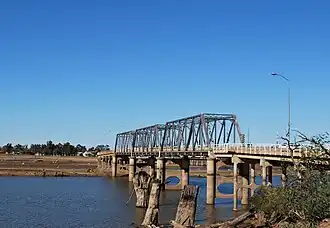 The Mulwala Bridge over an empty Lake Mulwala, in 2009. Yarrawonga can be seen on the far side of the empty lake and the original path of the Murray River is clearly visible. | |
| Coordinates | 36°00′15″S 146°00′15″E / 36.0043°S 146.0041°E |
| Carries | Motor vehicles, pedestrians |
| Crosses | Lake Mulwala, Murray River |
| Locale | Mulwala, New South Wales, Australia |
| Other name | Melbourne Street Bridge |
| Named for | Mulwala |
| Owner | |
| Maintained by | Transport for New South Wales |
Preceded by | John Foord Bridge |
Followed by | Yarrawonga Rail Bridge |
| Characteristics | |
| Design | Pratt truss |
| Material | Steel |
Trough construction | Concrete |
Pier construction | Concrete |
| Total length | 488 m (1,601 ft) |
| No. of spans | 3 |
| No. of lanes | 2 |
| History | |
| Designer | Percy Allan |
| Construction start | 1917 |
| Construction end | 1924 |
| Replaces | Wooden bridge (1891) |
| Statistics | |
| Daily traffic | c.8,500 vehicles |
| Location | |
Interactive map of Mulwala Bridge | |
The Mulwala Bridge is a road bridge that crosses the Murray River and connects Yarrawonga in Victoria and Mulwala in New South Wales, Australia. Completed in 1924, the Pratt truss bridge was designed by Percy Allan. The bridge spans Lake Mulwala, a reservoir formed by the Yarrawonga Weir, and forms part of the border between New South Wales and Victoria.[1]
History
The first formal crossing of the river between Mulwala village and the growing town of Yarrawonga was via a punt. A wooden bridge was built between 1889 and 1891,[2] and was the first road bridge built across the river. The lift bridge had four McDonald truss spans, the longest of which was 14.1 metres (46 ft).[3] Customs were collected for trade and passage across the bridge between the two colonies.[4] However, by 1915, the timber bridge started to become unsafe.[5] Remnants of the wooden pylons from the original bridge can be seen when water levels in the lake are low.
Commenced in 1917 and completed in 1924, the two-laned road bridge bridge was started from both ends, by the Victorian and NSW state governments. However, they did not coordinate their efforts, As a result the bridge has a dip and a bend in the middle to make the two ends meet.[4] Jointly owned by the respective state governments, the bridge is maintained by Transport for New South Wales, with costs shared equally.
The bridge was added to the New South Wales Heritage Inventory in 1999 as an item of local significance.[6]
Proposed new crossing
Since the late 1990s, there have been calls to replace the bridge.[7][8] In 2013, following Phase II of the Yarrawonga-Mulwala Bridge Planning Study, three routes were proposed for a new bridge:
- 'green' – aligned with the railway bridge, located approximately 200 metres (660 ft) to the west of the existing bridge;[9]
- 'yellow' – located approximately 150 metres (490 ft) west of the existing bridge; and
- 'grey' – located approximately 75 metres (246 ft) west of the existing bridge.[10]
In 2015, both the NSW and Victorian government endorsed the 'grey' route as the preferred option.[11] Following local plebiscites endorsing the 'green' route, further community consultation took place during 2021,[12][13] and in July 2022, the NSW Government changed its decision to endorse the 'green' route.[14] A further study of options was considered by the Victorian Government in 2025,[15][16] and they also changed their decision and endorsed the 'green' route in February 2026.[17][18] As of May 2026, the project was unfunded.
Adjacent crossings
A small bridge along the weir that served as a road crossing of the Murray was in operation from 1939 until its closure to motor vehicles in 2021, in order to protect the structural integrity of the weir.[19]
Gallery
 A sign mid-way across the bridge, entering the Pratt truss section, from the south-west
 Viewed from Yarrawonga, looking north-east across the lake towards Mulwala
See also
References
- ↑ "Mulwala Bridge over Murray River". Roads and Transport Authority (NSW). Retrieved 19 July 2010.
- ↑ March, Peter; Roads and Traffic Authority (May 1998). Murray River crossings heritage assessment: Mulwala bridge. Sydney: Hughes Trueman Reinhold. Retrieved 18 May 2026 – via Victorian Government Library Service.
- ↑ GHD Group (13 February 2014). "Appendices - Movable Span Bridge Study - Project, 22/16519" (PDF). Transport for New South Wales. Sydney. Retrieved 18 May 2026.
- 1 2 "Our History: Early Transport & Bridges of Yarrawonga Mulwala". Yarrawonga Mulwala Tourism Inc. n.d. Retrieved 18 May 2026.
- ↑ "Unusual bridge explained". S. E. Australia Memories, 1948-1951. n.d. Retrieved 18 May 2026 – via weebly.com.
- ↑ "Mulwala Bridge over Murray River". New South Wales Heritage Database. 2 February 1999. Retrieved 18 May 2026.
- ↑ "Petition gathers green route support for Yarrawonga-Mulwala bridge". ABC News. Australia. 1 May 2014. Retrieved 18 May 2026.
- ↑ "Federation Council raises bridge concerns with roads minister". Inside Local Government. 5 July 2022. Retrieved 18 May 2026.
- ↑ Prior, Emma (27 February 2023). "Bridge action in federal government". Dairy News Australia. Retrieved 18 May 2026.
- ↑ Yarrawonga-Mulwala Bridge planning study animation (streaming animated video). Transport Victoria. 5 May 2013 – via YouTube.
- ↑ Andrews, Daniel (18 November 2015). "Certainty For Yarrawonga And Mulwala Communities" (Press release). Victorian Government. Retrieved 18 May 2026.
- ↑ Planning for a future Murray River crossing at Mulwala: Community update (Report includes a map showing the proposed 'green' and 'grey' routes). Transport for New South Wales (Report). June 2021. Retrieved 18 May 2026.
- ↑ Mulwala Bridge: Community consultation summary (PDF). Transport for New South Wales (Report). December 2021. Retrieved 18 May 2026.
- ↑ "Mulwala Bridge: Project information: NSW Government confirms 'Green' route as preferred option". Transport for New South Wales. 27 October 2023. Retrieved 18 May 2026.
- ↑ Bunn, Anthony (10 April 2025). "'This crucial work....': Victorian government defends another crossing study" (Article includes aerial image of existing weir, railway bridge and road bridge). The Border Mail. Retrieved 18 May 2026.
- ↑ McKee, Christine (12 November 2025). "Editorial: A bridge too far". Yarrawonga Chronicle. Retrieved 18 May 2026.
- ↑ "Green light for 'Green' route" (Press release). Moira Shire. 23 February 2026. Retrieved 18 May 2026.
- ↑ Bunn, Anthony (24 February 2026). "Crucial decision made in the saga surrounding new Yarrawonga-Mulwala bridge". The Border Mail. Retrieved 18 May 2026.
- ↑ Smyrk, Katherine (14 October 2021). "Yarrawonga-Mulwala residents frustrated with fewer Murray River crossings amid bridge closure". ABC News. Australia. Retrieved 18 May 2026.
External links
 Media related to Mulwala Bridge at Wikimedia Commons
- Chapman, W. D. (1929). Construction of bridge over River Murray at Yarrawonga - superstructure (photo). Retrieved 18 May 2026 – via State Library of Victoria.