Magliano Sabina
Magliano Sabina | |
|---|---|
| Comune di Magliano Sabina | |
 View of Magliano Sabina | |
  Magliano Sabina Location of Magliano Sabina in Italy  Magliano Sabina Magliano Sabina (Lazio) | |
| Coordinates: 42°22′N 12°29′E / 42.367°N 12.483°E | |
| Country | Italy |
| Region | Lazio |
| Province | Province of Rieti (RI) |
| Area | |
• Total | 43.7 km2 (16.9 sq mi) |
| Elevation | 222 m (728 ft) |
| Population (Dec. 2004)[2] | |
• Total | 3,829 |
| • Density | 87.6/km2 (227/sq mi) |
| Demonym | Maglianesi |
| Time zone | UTC+1 (CET) |
| • Summer (DST) | UTC+2 (CEST) |
| Postal code | 02046 |
| Dialing code | 0744 |
| Website | Official website |
Magliano Sabina (Local dialect: Majjanu) is a comune (municipality) in the Province of Rieti in the Italian region of Latium, at Tiber Valley.
Territory
Located long Tiber Valley, about 65 kilometres (40 mi) north of Rome, about 35 kilometres south of Terni, 40 kilometres east of Viterbo and 50 kilometres (31 mi) west of Rieti. As of 31 December 2004, it had a population of 3,829 and an area of 43.7 square kilometres (16.9 mi2).[3]
Magliano Sabina borders the following municipalities: Calvi dell'Umbria, Civita Castellana, Collevecchio, Gallese, Montebuono, Orte, Otricoli.
Its frazione of Foglia is one of I Borghi più belli d'Italia ("The most beautiful villages of Italy").[4]
The Cathedral is also known as the Concattedrale di San Liberatore Vescovo e Martire.
Demographic evolution
Historical population | |||||||||||||||||||||||||||||||||||||||||||||||||||||
|
|
| |||||||||||||||||||||||||||||||||||||||||||||||||||
 | |||||||||||||||||||||||||||||||||||||||||||||||||||||
| Source: Data from ISTAT | |||||||||||||||||||||||||||||||||||||||||||||||||||||
Gallery
 The old Felice bridge in 1676
 Stamnos red figure ceramic attic vase in the Civic Archaeological Museum of Magliano
 Archaic iron weapons from the Archaeological Museum of Magliano Sabina
 Iron and bronze repert in the Civic Archaeological Museum of Magliano
 Roman anphore in the Civic Archaeological Museum of Magliano
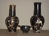 Archaic aphore in the Civic Archaeological Museum of Magliano
 Litic repert, flint scrapers, Archaeological area of Poggio Sommavilla, at Civic Archaeological Museum of Magliano
 Olletta with archaic inscription of Gilio's necropolis, Civic Archaeological Museum of Magliano
 Flaminia Verga, Archaeological map of Tiber Valley, Florence 2006
 Magliano Sabina in Archaeological map - Falerii e la sua regione rivelata dai sepolcreti, Mancinelli Scotti Francesco
Museum
- Civic archaeological museum of Magliano Sabina [it]
See also
References
- ↑ "Superficie di Comuni Province e Regioni italiane al 9 ottobre 2011". Italian National Institute of Statistics. Retrieved 16 March 2019.
- ↑ "Popolazione Residente al 1° Gennaio 2018". Italian National Institute of Statistics. Retrieved 16 March 2019.
- ↑ All demographics and other statistics: Italian statistical institute Istat.
- ↑ "Lazio" (in Italian). Retrieved 1 August 2023.
External links