Knippa, Texas
Knippa, Texas | |
|---|---|
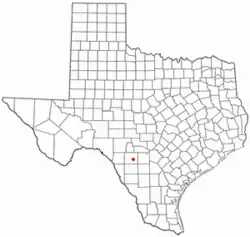 Location of Knippa, Texas | |
 | |
| Coordinates: 29°18′28″N 99°37′50″W / 29.30778°N 99.63056°W | |
| Country | United States |
| State | Texas |
| County | Uvalde |
| Area | |
• Total | 5.2 sq mi (13.5 km2) |
| • Land | 5.1 sq mi (13.2 km2) |
| • Water | 0.077 sq mi (0.2 km2) |
| Elevation | 994 ft (303 m) |
| Population (2020) | |
• Total | 606 |
| • Density | 119/sq mi (45.9/km2) |
| Time zone | UTC-6 (Central (CST)) |
| • Summer (DST) | UTC-5 (CDT) |
| ZIP code | 78870 |
| Area code | 830 |
| FIPS code | 48-39664[2] |
| GNIS feature ID | 2408497[1] |
Knippa (/kəˈnɪpə/ kə-NIP-ə) is a census-designated place (CDP) in Uvalde County, Texas, United States. Its population was 606 at the 2020 census, down from 689 in 2010. It is part of the Uvalde, Texas micropolitan statistical area.
Geography
Knippa is accessible via U.S. Route 90 and Farm to Market Road 1049.[3]
According to the United States Census Bureau, the CDP has a total area of 5.2 square miles (13.5 km2), of which 0.08 square miles (0.2 km2), or 1.82%, is covered by water.[4]
Demographics
| Census | Pop. | Note | %± |
|---|---|---|---|
| 2000 | 739 | — | |
| 2010 | 689 | −6.8% | |
| 2020 | 606 | −12.0% | |
| U.S. Decennial Census[5] 1850–1900[6] 1910[7] 1920[8] 1930[9] 1940[10] 1950[11] 1960[12] 1970[13] 1980[14] 1990[15] 2000[16] 2010[17] 2020[18] | |||
Knippa first appeared as a CDP in the 2000 U.S. census.[16]
2020 census
| Race / Ethnicity (NH = Non-Hispanic) | Pop 2000[19] | Pop 2010[20] | Pop 2020[21] | % 2000 | % 2010 | % 2020 |
|---|---|---|---|---|---|---|
| White alone (NH) | 318 | 265 | 217 | 43.03% | 38.46% | 35.81% |
| Black or African American alone (NH) | 2 | 1 | 8 | 0.27% | 0.15% | 1.32% |
| Native American or Alaska Native alone (NH) | 5 | 2 | 2 | 0.68% | 0.29% | 0.33% |
| Asian alone (NH) | 0 | 0 | 1 | 0.00% | 0.00% | 0.17% |
| Native Hawaiian or Pacific Islander alone (NH) | 0 | 0 | 0 | 0.00% | 0.00% | 0.00% |
| Other race alone (NH) | 0 | 0 | 0 | 0.00% | 0.00% | 0.00% |
| Multiracial (NH) | 5 | 1 | 20 | 0.68% | 0.15% | 3.30% |
| Hispanic or Latino (any race) | 409 | 420 | 358 | 55.35% | 60.96% | 59.08% |
| Total | 739 | 689 | 606 | 100.00% | 100.00% | 100.00% |
As of the census[2] of 2000, 739 people, 246 households, and 180 families resided in the CDP. The population density was 70.9 inhabitants per square mile (27.4/km2). There were 280 housing units at an average density of 26.9 per square mile (10.4/km2). The racial makeup of the CDP was 71.58% White, 0.27% African American, 0.81% Native American, 0.41% Pacific Islander, 20.57% from other races, and 6.36% from two or more races. Hispanic or Latino people of any race were 55.35% of the population.
Of the 246 households, 42.7% had children under 18 living with them, 60.6% were married couples living together, 10.2% had a female householder with no husband present, and 26.8% were not families. About 24.8% of all households were made up of individuals, and 9.3% had someone living alone who was 65 or older. The average household size was 3.00, and the average family size was 3.69.
In the CDP, the age distribution was 33.6% under 18, 10.3% from 18 to 24, 27.2% from 25 to 44, 19.8% from 45 to 64, and 9.2% who were 65 or older. The median age was 30 years. For every 100 females, there were 98.7 males. For every 100 females 18 and over, there were 97.2 males.
The median income for a household in the CDP was $29,375 and for a family was $31,667. Males had a median income of $20,741 versus $19,722 for females. The per capita income for the CDP was $9,790. About 15.5% of families and 20.0% of the population were below the poverty line, including 24.1% of those under 18 and 23.2% of those 65 or over.
Education
Knippa is served by the Knippa Independent School District.
Climate
The climate in this area is characterized by hot, humid summers and generally mild to cool winters. According to the Köppen climate classification, Knippa has a humid subtropical climate, Cfa on climate maps.[22]
References
- 1 2 U.S. Geological Survey Geographic Names Information System: Knippa, Texas
- 1 2 "U.S. Census website". United States Census Bureau. Retrieved January 31, 2008.
- ↑ Transportation Planning and Programming Division (2018). Texas County Mapbook (PDF) (Map) (2018 ed.). 1:72,224. Texas Department of Transportation. p. 1901. Retrieved June 7, 2023.
- ↑ "Geographic Identifiers: 2010 Demographic Profile Data (G001): Knippa CDP, Texas". United States Census Bureau. Retrieved March 29, 2012.
- ↑ "Decennial Census by Decade". United States Census Bureau.
- ↑ "1900 Census of Population - Population of Texas By Counties And Minor Civil Divisions" (PDF). United States Census Bureau.
- ↑ "1910 Census of Population - Supplement for Texas" (PDF). United States Census Bureau. Archived from the original (PDF) on March 30, 2025. Retrieved July 13, 2024.
- ↑ "1920 Census of Population - Number of Inhabitants - Texas" (PDF). United States Census Bureau.
- ↑ "1930 Census of Population - Number of Inhabitants - Texas" (PDF). United States Census Bureau.
- ↑ "1940 Census of Population - Number of Inhabitants - Texas" (PDF). United States Census Bureau.
- ↑ "1950 Census of Population - Number of Inhabitants - Texas" (PDF). United States Census Bureau.
- ↑ "1960 Census of Population - Number of Inhabitants - Texas" (PDF). United States Census Bureau.
- ↑ "1970 Census of Population - Number of Inhabitants - Texas" (PDF). United States Census Bureau.
- ↑ "1980 Census of Population - Number of Inhabitants - Texas" (PDF). United States Census Bureau.
- ↑ "1990 Census of Population - Population and Housing Unit Counts - Texas" (PDF). United States Census Bureau.
- 1 2 "2000 Census of Population - Population and Housing Unit Counts - Texas" (PDF). United States Census Bureau.
- ↑ "2010 Census of Population - Population and Housing Unit Counts - Texas" (PDF). United States Census Bureau.
- ↑ "Census Bureau profile: Knipp, Texas". United States Census Bureau. May 2023. Retrieved June 4, 2024.
- ↑ "P004: Hispanic or Latino, and Not Hispanic or Latino by Race – 2000: DEC Summary File 1 – Knippa CDP, Texas". United States Census Bureau.
- ↑ "P2: Hispanic or Latino, and Not Hispanic or Latino by Race – 2010: DEC Redistricting Data (PL 94-171) – Knippa CDP, Texas". United States Census Bureau.
- ↑ "P2: Hispanic or Latino, and Not Hispanic or Latino by Race – 2020: DEC Redistricting Data (PL 94-171) – Knippa CDP, Texas". United States Census Bureau.
- ↑ Climate Summary for Knippa, Texas
Municipalities and communities of Uvalde County, Texas, United States | ||
|---|---|---|
| Cities |  | |
| CDPs | ||
| Other community | ||
| Ghost town | ||