Inchmickery
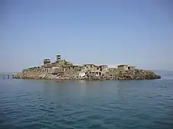

Inchmickery is a small island in the Firth of Forth in Scotland. It is about two miles (3.2 km) north of Edinburgh.
Its name comes from the Scottish Gaelic, Innis nam Biocaire, meaning Isle of the Vicars, implying that there may have been an old ecclesiastical or Culdee settlement here, as in nearby Inchcolm. It features occasionally in a riddle, "How many inches is the Forth?", playing on a pun on 'Inch' (Innis), the Gaelic word for island, and inch, the imperial measurement.
Inchmickery is tiny, only 100 metres by 200 metres. During both World War I and World War II the island was used as a gun emplacement. The concrete buildings make the island look (from a distance) like a battleship. Although the island is now uninhabited much of this concrete superstructure remains largely intact.
The conclusion of Iain Banks's 1993 novel Complicity was set here and the film adaptation used it as a location.
The island is now an RSPB reserve, and is home to breeding pairs of common eider, Sandwich terns and various gulls. It used to be a nesting site for the very rare roseate tern, but the roseate terns have now moved elsewhere in the Firth of Forth. There are exposed rocks off Inchmickery, known as the Cow & Calves.
Inchmickery was formerly known for its oyster-beds,[1] and used to be covered in moss and lichen.
Geography and geology
Inchmickery lies in the inner Firth of Forth, approximately 3 km (1.9 mi) north of Silverknowes on the Edinburgh shore, and has an area of about 1.3 ha (3.2 acres).[2] The island is low and small and the surviving military structures occupy much of its land area.[2]
Geologically, Inchmickery is formed by an igneous intrusion known as the Inchmickery Sill, composed of teschenitic dolerite.[3] The sill continues north-northeastwards beneath and above the waters of the Forth, with exposures forming the nearby Cow and Calves, Oxcars and Car Craig skerries.[3] The British Geological Survey records the sill as intruding rocks at the top of the Charles Hill Volcanic Member of the Anstruther Formation, placing Inchmickery within the complex Carboniferous volcanic and intrusive geology characteristic of the Edinburgh district.[3]
History

The island appears in surviving records as Mickry by 1630, with the part "Inch", derived from the Gaelic innis ("island") being added to the name only in the nineteenth century.[4]
Inchmickery was particularly associated with its surrounding oyster bed.[5] In 1899, the island was described as being renowned for the valuable oyster bed surrounding it, although the fishery had already become impoverished through excessive dredging.[5] The wider native oyster fishery of the Firth of Forth subsequently collapsed.[6] A native European flat oyster recorded at Inchmickery in 1947 was the only confirmed twentieth-century record from the firth of Forth identified in later research.[6]
Fortifications
Inchmickery formed part of the extensive system of coastal defences protecting the Firth of Forth, whose strategic importance increased with the development of Rosyth Dockyard and the use of the firth as a major naval anchorage.[7] Plans drawn up before the First World War envisaged a line of batteries on Inchcolm, Oxcars, Inchmickery and Cramond Island covering an anti-boat obstruction across the Forth, although it was subsequently recognised that Inchmickery and Oxcars were too small to accommodate all of the guns originally proposed.[8] The position of Inchmickery was important because it lay around 8,000 yd (7,300 m) east of the Forth Bridge, close to the distance at which contemporary torpedoes could threaten Royal Navy ships using the anchorage.[8]
During the First World War Inchmickery became part of the Middle Defences of the Forth.[9] The island was fortified in 1915 as part of the strengthening of the defences against German submarines and other enemy vessels approaching the naval anchorage.[10] The initial armament comprised quick firing guns intended to engage small, fast moving vessels if they attemlted to penetrate the defended area.[9] Following the wider reorganisation of the Forth defences during 1916, Inchmickery was equipped with 4 inch quick firing guns, weapons which had principally been developed for naval service but were also used in the Forth's coast defences.[7] The battery formed part of a coordinated defensive system in which guns, electric searchlights, booms and other obstructions were intended to prevent hostile vessels from reaching the important naval facilities farther upriver.[7] The island was fortified again during the Second World War as part of the anti-motor torpedo boat defences of the Forth.[7] Work undertaken in 1939–40 included reconstruction of the defences on Inchmickery and Inchcolm, with the Edinburgh firm John Best & Sons employed on the project.[7] Inchmickery was equipped with twin 6-pounder quick firing guns, a type specifically developed for coast defence against fast motor torpedo boats and other small coastal craft.[11] The twin mounting placed two barrels side by side in a rotating steel cabin and used a semi-automatic breech to permit a particularly high rate of fire, with targeting information supplied from a separate director and rangefinder.[11] At Inchmickery the guns were supported by defence electric lights and associated observation and fire control positions.[7]
By March 1944, Inchmickery had been reduced to care and maintenance as the perceived threat to the Forth diminished towards the end of the war and personnel were released from coast defence duties.[12] The surviving military remains occupy much of the small island and include gun emplacements from both world wars, battery observation and fire control structures, searchlight positions, engine and generating buildings, stores, a pillbox, pier and jetty.[10] The concentration of concrete buildings has resulted in a frequently repeated claim that the wartime structures were deliberately arranged to make Inchmickery resemble a battleship when seen from a distance, but a survey by the Royal Commission on the Ancient and Historical Monuments of Scotland found no evidence that this appearance was an intentional form of camouflage.[10] The surviving defences are protected as a scheduled monument.[10]
See also
References
- ↑ "Ibris – Issay – British History Online" – via British History Online.
- 1 2 "Forth Defences, Middle, Inchmickery Battery". Trove. Historic Environment Scotland. Retrieved 9 August 2026.
- 1 2 3 Browne, M. A. E.; Gould, D.; Akhurst, M. C.; Monaghan, A.; Reeves, T. (2025). Geology of the Edinburgh district (Report). British Geological Survey Open Report. British Geological Survey. pp. 93–94. Retrieved 9 August 2026.
- ↑ Taylor, Simon (2024). "The early Irish grammaticus: Cormac's Orthography, the cult of Columba and the place-name Inchcolm". Journal of Scottish Name Studies. 18: 371–401. Retrieved 9 August 2026.
- 1 2 Coastal Assessment Survey: The Firth of Forth from Dunbar to the Coast of Fife (PDF) (Report). GUARD. 1996. p. 149. Retrieved 9 August 2026.
- 1 2 Cooper-Young, E. L. M. Site optimisation for native oyster (Ostrea edulis) restoration in the Firth of Forth (PDF) (Thesis). Heriot-Watt University. Retrieved 9 August 2026.
- 1 2 3 4 5 6 Barclay, Gordon J.; Morris, Ron (2019). The Fortification of the Firth of Forth 1880–1977: 'The most powerful naval fortress in the British Empire'. Edinburgh: Society of Antiquaries of Scotland. pp. 120–124. doi:10.9750/9781908332264. ISBN 978-1-908332-14-1.
- 1 2 Barclay, Gordon J.; Morris, Ron (2019). The Fortification of the Firth of Forth 1880–1977: 'The most powerful naval fortress in the British Empire'. Edinburgh: Society of Antiquaries of Scotland. p. 44. doi:10.9750/9781908332264. ISBN 978-1-908332-14-1.
- 1 2 Barclay, Gordon J.; Morris, Ron (2019). The Fortification of the Firth of Forth 1880–1977: 'The most powerful naval fortress in the British Empire'. Edinburgh: Society of Antiquaries of Scotland. p. 117. doi:10.9750/9781908332264. ISBN 978-1-908332-14-1.
- 1 2 3 4 "Forth Defences, Middle, Inchmickery Battery". Trove. Historic Environment Scotland. Retrieved 9 August 2026.
- 1 2 Barclay, Gordon J.; Morris, Ron (2019). The Fortification of the Firth of Forth 1880–1977: 'The most powerful naval fortress in the British Empire'. Edinburgh: Society of Antiquaries of Scotland. pp. 18–20. doi:10.9750/9781908332264. ISBN 978-1-908332-14-1.
- ↑ Barclay, Gordon J.; Morris, Ron (2019). The Fortification of the Firth of Forth 1880–1977: 'The most powerful naval fortress in the British Empire'. Edinburgh: Society of Antiquaries of Scotland. p. 79. doi:10.9750/9781908332264. ISBN 978-1-908332-14-1.