Habung
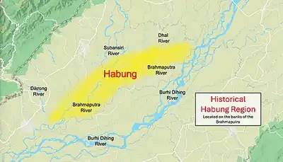
Habung is a historical region in present-day Lakhimpur district of Assam,[1][2] although some claim it to be a part of present-day Dhemaji district.[3][4] Some authors have identified "Habung" with the Havvaṅga-vishaya (rendered Havrnga-vishaya or Ha-Vrnga-vishaya in some earlier scholarship), a vishaya or province where a Brahmin was granted land by Ratna Pala of the Pala dynasty of Kamarupa in the 10th century,[5] After the fall of Kamrupa, the region became part of Chutia kingdom where Chutia kings made land grants to Brahmins.[6][7] Sukaphaa, the first Ahom king, is known to have spent three years in Habung before finally settling down at Charaideo in 1253.[8]
History
Early history
The earliest proposed reference to Habung, according to some historians, is found in the 10th-century copper-plate grant of Ratna Pala of the Pala dynasty, which mentions a province (vishaya) read by epigraphist D. C. Sircar as Havvaṅga-vishaya, where Brahmin settlements had been established. The name was rendered Havrnga, Havranga or Ha-Vrnga in some earlier scholarship, and some historians identified this province with the historical Habung region.[9][10]: 62
P. C. Choudhury supported this identification partly through his interpretation of the geographical boundaries in Ratnapala's Saratbari copper-plate grant, including the Divvaiśā (also rendered Dibbaisa) river forming the southern boundary and his reading of a supposed river named Saicha as the south-western boundary of the gifted land, which he identified with the modern Sessa river of Lakhimpur. On this basis, he identified Havranga-vishaya with the Habung country lying east of the Subansiri, broadly corresponding to the present-day Dhakuakhana region.[11]
This particular boundary interpretation was subsequently questioned by epigraphist D. C. Sircar in his re-edition of the Saratbari plates, in which the name of the province is read as Havvaṅga-vishaya. Sircar described the proposed identification of a Saicha river as one of Choudhury's "unwarranted suggestions" and stated that the relevant expression was not Saicha but s-aiva (sā eva, "that same"), referring back to the previously mentioned Divvaiśā river.[10]: 64–69 Sircar also noted that a river or stream called Divvaiśā occurs in the Ulubari plates of Balavarman; the land granted in that charter was situated at Dikkūra in Mañjai-vishaya, within Uttarakūla, the division lying north of the Brahmaputra, and thus belonged to a different vishaya from Havvaṅga.[12][10]: 64–69 It is known that Sukaphaa, the first Ahom king, spent a few years in Habung before finally settling at Charaideo in 1253.[8]
Medieval period

Copperplates of land grants made in this region are those by the Chutia kings, that date back to the year 1392 AD when king Satyanarayan donated 600 puti of land to a Brahman named "Narayan Dwij" at Dhenukhana.[13] This was the time when the Ahom prince Sudangphaa was still living with his Brahmin foster family at Habung.[14] The copper plate of Chutia king Dharmanarayan dated 1428 A.D. mentions Sri Vrihat-patra as Habung-aadhipati (lord of Habung). The plate records land grants of 400 puti given to a Brahmin named Purandar Vipra, indicating that Habung was a principality of the Chutia kingdom.[15]
The land grant reads,
“Purandharai Viprai Bhuputinang Saturkhatam
Nripadeshata Samagatya Dadadi-Sashana Dadou-Habung-adhi”
— Copper plate dated to 1428 found in Chapakhowa, Sadiya(Scribe: Swarnakara Krishna Sadhu)
Suhungmung, the Ahom king, following an expansionist policy and annexed Panbari of Habung in 1512 AD, which was a part of the Chutia kingdom.[16] The Chutia king Dhirnarayan attacked the Ahoms at Dikhoumukh the next year, but was unsuccessful. The Chutias again attacked the Ahoms in 1520 and occupied the areas up to Namdang and Mungkhrang.[17] The last copperplate recording a grant made in the region was issued by king Dhirnarayan in 1522 A.D. at a place known as Konwargaon (present-day Dhakuakhana) after which the region was finally annexed by the Ahom king Suhungmung in 1523 A.D.[18]
In 1525, the Ahoms created offices for the newly acquired regions, including Thao-mung Mung-teu (Bhatialia Gohain) with headquarters at Habung.[19][20] In 1527, Suhungmung created the office of the Borpatrogohain, apparently deriving its designation from the Chutia Vrhat-patra of Habung[21] and Klangseng (previously posted as Bhatialia Gohain) was given charge.[22][23][a] The Chutia Borpatra official appears to have been retained until the later part of the reign of Suklenmung. He was killed following a rebellion led by a Brahmin official against the king; the rebel Brahmin, however, escaped and fled to Koch Bihar.[26]
Popular culture
The Habung region finds mention in several folk songs and tales. For instance, there is a Nisukoni geet (a form of lullaby) where the author talks about an old man (Habungia Burha) and a carpenter (Habungia Barhoi) from Habung.
"Haliki ei baper koloi gol,
Habungia burhar logot kah kubai gol.
.....
Habungia Barhoiye Charanao haje
Kurular keruhen uru uru kore,
Uribo nuwarihe sagarote pore."
Notes
- ↑ Wade (1800), in An Account of Assam, notes that the region at the confluence of the Subansiri and the Brahmaputra rivers was known as Habung. He also mentions that it was located near the districts of Gazlung, Narua and Telehi, all of which are located near the Subansiri River.
- ↑ Neog, Maheswar (1977). "Light on a Ruling Dynasty of Arunachal Pradesh in the Fourteenth and Fifteenth Centuries". Annals of the Bhandarkar Oriental Research Institute. 58/59: 818. ISSN 0378-1143. JSTOR 41691751.
Habunga province (the Subansiri region of the present-day North Lakhimpur district)
- ↑ Saikia (2004), p. 28:"Dhemaji is more political and therefore somewhat more volatile than Patsako. Tai-ahom activism was very visible there, so much so that the first capital city of the Ahom swargadeos, Habung, was identified and claimed to be in Dhemaji."
- ↑ Saikia, Yasmin (1997). In the Meadows of Gold: Telling Tales of the Swargadeos at the Crossroads of Assam. Guwahati: Spectrum Publications. p. 188.
An important city within the Chutia domain. The exact location of Habung remains a controversy. Recently, on one of my field trips to Dhemaji, in the Lakhimpur district, I visited Borajaha Sapari, which since 1990 has been identified as Habung. The Ahom Land Demand Movement claims this spot as their future capital.
- ↑ "Habung was an ancient Brahmin settlement (Havrnga-Vishaya) situated near the mouth of the Dihing river." (Guha 1983:11) "According to tradition, Habung was a petty medieval principality governed by its Brahmin settlers themselves. It now appears from a recently found copper plate inscription that it was the same as the Ha-Vrnga Vishaya where a Brahmin was given land by King Ratnapala. (c 10th century) (Guha 1983:33f)
- ↑ Guha, Amalendu,Pre-Ahom Roots and the Medieval State in Assam: A Reply, p. 73, Before its annexation by Ahoms, Habung was a Chutia dependency
- ↑ A Chutia chief named Vrihat-patra referred to as Habung-adhipati is mentioned in the copper plate of Durlabhnarayan dated to 1428 A.D. Another plate of Dhirnarayan dated 1522 AD was found in the region which indicates that Habung was reclaimed by Chutias in 1520 A.D. during the war of Dihinhmukh
- 1 2 Phukan 1992, p. 53.
- ↑ Habung was a Chutiya dependency; that still earlier it was an autonomous principality of Brahmins; and that the latter's origins could be traced back to a circa 10th-century copper-plate grant issued by king Ratnapala. (Guha 1984:73)
- 1 2 3 Sircar, D. C. (1986). "Three Copper-Plate Grants from Assam" (PDF). Epigraphia Indica. 40. Archaeological Survey of India.
- ↑ The mention of Dibbaisa river forming southern boundary and Saica the south-western boundary led P.C. Choudhury to identify the Havranga visaya with Habung country lying to east of the river Suvansiri during the 10th-11th century A.D. Habung, comprising present Dhakuakhana region was for centuries a centre of Aryan culture
- ↑ Sircar, D. C. (1990), "Pragjyotisha-Kamarupa", in Barpujari, H. K. (ed.), The Comprehensive History of Assam, vol. 1, Guwahati: Publication Board, Assam, pp. 71–74
- ↑ (Baruah 2007:38–39) : Two of these copperplates were issued by king Satyanarayan in 1314 saka (1392 AD)....This land was part of the Habung region where several Brahmin families had been settled.
- ↑ (Baruah 1986:225)
- ↑ (Baruah 2007:585)
- ↑ (Baruah 2007:128) : Suhungmung attacked Panbari, the western region of Habung province, situated on the North bank of Luit (Brahmaputra) in the year 1512. Habung was a part of Chutia kingdom...This is the reason why the Chutia king Dhirnarayan launched a naval as well as land attack against the Ahoms in the year 1513 at Dikhoumukh.
- ↑ Gait, Edward, "A History of Assam, p.84 The Chutias made no effort to regain their lost territory until 1520, when they attacked the Ahom fort at Mungkhrang. The Ahom commander was killed in a sortie and the garrison fled; and for a time the Chutias once more ruled this tract of country.
- ↑ (Baruah 2007:41–42)
- ↑ Barua, Gopal Chandra, Ahom Buranji, p. 55
- ↑ (Gait 1963:8) In 1525, Suhungmung proceeded in person to the Dihing country and appointed officers to administer the frontier provinces of Habung, Dihing, and Banlung.
- ↑ (Guha 1983:20) "It appears that the novel designation of Barpatragohain was borrowed from the civil list of Habung where the local ruler, a dependent of the Chutiya king, had the title of Vrhat-Patra."
- ↑ Thao-mung mungteu(Bhatialia Gohain) was made Chao-sheng-lung in Lakni Rungrao 1527.(p.61.)
- ↑ Klangseng is mentioned as Chao-sheng-lung in Lakni Dapplao 1531.(p.64)
- ↑ Barua, Gopal Chandra, Ahom Buranji, p. 55
- ↑ Bhuyan, S.K., Deodhai Asam Buranji, Chapter 31
- ↑ Mahanta, Sukumar, Assam Buranji, p.25, "At that time, the king said, 'By subduing the Sutias and suppressing the Bhuyans, my father and I have taken their kingdom. Why, then, is a Brahmin seeking to become king—why have I appointed the Sutia Borpatro for?' Saying this, the Borpatra was executed. The king then attempted to execute the Brahmin as well, but he fled and escaped to Koch Bihar."
References
- Saikia, Yasmin (2004). Fragmented Memories: Struggling to be Tai-Ahom in India. Duke University Press. ISBN 9780822333739.
- Acharyya, N.N (1987). A Brief History of Assam. Omsons Publications. pp. 71–73.
- Gogoi, Padmeswar (1968). The Tai and the Tai kingdoms: with a fuller treatment of the Tai-Ahom kingdom in the Brahmaputra Valley (First ed.). Dept. Of publication, Gauhati University. pp. 259–265.
- Guha, Amalendu (1983), "The Ahom Political System: An Enquiry into the State Formation Process in Medieval Assam (1228-1714)" (PDF), Social Scientist, 11 (12): 3–34, doi:10.2307/3516963, JSTOR 3516963
- Gait, Sir Edward Albert (1963). A History of Assam. Thacker, Spink. Archived from the original on 6 July 2023. Retrieved 4 May 2020.
- Wade, John Peter (1800), An Account of Assam, pp. 13–16
- Guha, Amalendu (June 1984). "Pre-Ahom Roots and the Medieval State in Assam: A Reply". Social Scientist. 12 (6): 70. doi:10.2307/3517005. JSTOR 3517005.
- Baruah, Swarnalata (2007). Chutia Jatir Buranji.
- Phukan, J. N. (1992), "The Tai-Ahom Power in Assam", in Barpujari, H. K. (ed.), The Comprehensive History of Assam, vol. 2, Guwahati: Assam Publication Board, pp. 49–60
- Baruah, S L (1986), A Comprehensive History of Assam, Munshiram Manoharlal