Dikhow River
| Dikhow River | |
|---|---|
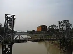 Old Dikhow Bridge in Sivasagar which was built by the British in 1935 | |
  Location within Assam  Location within India | |
| Location | |
| State | Assam, Nagaland |
| Districts | Sivasagar |
| Physical characteristics | |
| Source | Longleng |
| • location | Zunheboto district, Nagaland |
| • coordinates | 26°44′45.7″N 94°48′24.8″E / 26.746028°N 94.806889°E |
| Mouth | Brahmaputra River |
• location | Dikhowmukh, Sivasagar district, Assam |
• coordinates | 27°00′00.2″N 94°27′52.8″E / 27.000056°N 94.464667°E |
| Basin features | |
| Progression | Dikhow River- Brahmaputra River |
The Dikhow River is a left tributary of the Brahmaputra River in the Indian state of Assam. It rises in the Zunheboto district in Nagaland, flows through the Sivasagar district of Assam and joins the Brahmaputra at Dikhowmukh.[1][2]

Historical course
Historical accounts indicate that the lower course of the Dikhow has changed considerably. Early Buranji narratives describe Dikhaumukh as a point on the main Brahmaputra–Lohit river system from which the Dikhow could be entered and navigated upstream, while accounts of the seventeenth century describe a later configuration in which the Dikhow discharged into the former Dihing channel south of Majuli.
In the migration narrative of Sukaphaa preserved in the Ahom-Buranji, Sukaphaa is said to have left Habung and proceeded downstream along the Tilao (Lohit) until reaching Dikhaumukh, from where he travelled upstream along the Dikhow to Dilimukh and the interior of the present Sivasagar region.[3]
Dikhaumukh was also an important military position during the early sixteenth century. In 1513, during the Ahom–Chutia conflicts, the Ahom-Buranji records that the Chutia king Dhitnarayan advanced against the Ahoms and established his position at Dikhaumukh.[4] Other Buranji accounts of the conflict describe the Chutia forces as retreating eastwards from Dikhaumukh towards the Dihing and subsequently towards Dibrumukh and Sadiya.[5]
Accounts of the Koch invasions in the sixteenth century likewise describe Dikhaumukh in relation to the main Brahmaputra–Tilao channel. During an invasion in 1562, the Ahom-Buranji records that the Koch forces proceeded upstream along the Tilao to Dikhaumukh, where the Ahom commanders assembled to oppose them; after fighting there the Koch fleet withdrew downstream to the mouth of the Handia.[6] In the following campaign, the Koch king again advanced upstream along the Tilao and constructed a fort on the mouth of Dikhow (Sup-Nam-chao), on the other side of the Tilao, while the Ahoms constructed an opposing fort and stationed forces at the mouth of the Dihing (Sup-Nam-Jin). The same narrative subsequently records the devastation of the province of Marangi by the Koch forces.[7]
The distinction between the Dihing and Dikhaumukh is also apparent in an itinerary recorded for 1648. The Ahom-Buranji states that the Ahom king travelled downstream along the Dihing to Bholatali and subsequently travelled by the Tilao; later in the same journey he proceeded downstream along the Tilao from Barbil and stopped at the mouth of the Dikhow.[8]
By the time of Mir Jumla's invasion of Assam in 1662, however, a different drainage configuration is recorded. Edward Gait states that the Brahmaputra or Luit then flowed north of Majuli, while the Dihing followed approximately the channel now occupied by the Brahmaputra south of the island. In this configuration the Dihing received the Disang river and the Dikhow before rejoining the northern Brahmaputra at Lakhau, at the western extremity of Majuli.[9] During the Mughal occupation, outposts were established north of Garhgaon at Ramdang and Trimohini, the latter being identified by Gait as the place where the Dikhow then fell into the Dihing.[10]
Gait also recorded a native tradition concerning a still earlier course of the river. According to this tradition, the Dikhow formerly had an independent course extending as far west as Kajalimukh, with portions of the former channel believed to survive as the Tuni river in Majuli and the Kallang in Nagaon district.[11]
References
- ↑ "Action Plan for Dikhow River at Dikhow Bridge by Pollution Control Board of Assam" (PDF). Pollution Control Board, Assam.
- ↑ "Ground Water Information Booklet Sibsagar District, Assam" (PDF). General Portal of Central Ground Water Board, Ministry of Jal Shakti, Department of Water Resources, Government of India.
- ↑ Barua, Golap Chandra (1930). Ahom-Buranji: From the Earliest Time to the End of Ahom Rule. Calcutta: Assam Administration. pp. 46–47.
As the place was very often flooded by water, he proceeded downstream the river Tilao (Lohit) and arrived at Dikhaumukh. He advanced upstream the Dikhau river and came to Dilimukh.
- ↑ Barua, Golap Chandra (1930). Ahom-Buranji: From the Earliest Time to the End of Ahom Rule. Calcutta: Assam Administration. p. 55.
In lakni, Mungmut (i.e., in 1513 A.D.), the Chutia king, Dhirnarayan made a hostile march against our king and took his station at Dikhaumukh.
- ↑ Bhuyan, S. K. (ed.). Satsari Assam Buranji. Gauhati: Gauhati University.
- ↑ Barua, Golap Chandra (1930). Ahom-Buranji: From the Earliest Time to the End of Ahom Rule. Calcutta: Assam Administration. pp. 84–85.
- ↑ Barua, Golap Chandra (1930). Ahom-Buranji: From the Earliest Time to the End of Ahom Rule. Calcutta: Assam Administration. pp. 85–86.
the Koch king invaded our country and coming upstream the river Tilao, prepared a fort in front of the Dikhau river on the other side of the Tilao.
- ↑ Barua, Golap Chandra (1930). Ahom-Buranji: From the Earliest Time to the End of Ahom Rule. Calcutta: Assam Administration. p. 131.
the king proceeded down-stream the Dihing river to Bholatali ... the king proceeded downstream the Tilao from Barbil and stopped at the mouth of the Dikhau river.
- ↑ Gait, Edward Albert (1926). A History of Assam (2nd ed.). Calcutta and Simla: Thacker, Spink & Co. p. 132.
the Dihing followed the present channel of the Brahmaputra to the south of it, and, after receiving the waters of the Disang and the Dikhu, united with the Brahmaputra at its western extremity.
- ↑ Gait, Edward Albert (1926). A History of Assam (2nd ed.). Calcutta and Simla: Thacker, Spink & Co.
- ↑ Gait, Edward Albert (1926). A History of Assam (2nd ed.). Calcutta and Simla: Thacker, Spink & Co. p. 132.
At that time, according to native traditions, the Dikhu had an independent course as far as Kajalimukh, part of which still survives in the Majuli as the Tuni river, and part in Nowgong, as the Kallang.