Geshur (Israeli settlement)
Geshur
| |
|---|---|
 | |
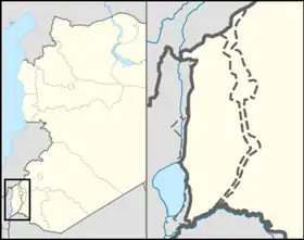  Geshur Location within the Golan Heights  Geshur Location within the Golan Heights | |
| Coordinates: 32°49′10″N 35°42′56″E / 32.81944°N 35.71556°E | |
| Country | Israel |
| District | Northern |
| Subdistrict | Golan |
| Council | Golan |
| Region | Golan Heights |
| Affiliation | Kibbutz Movement |
| Founded | 1971 |
| Founded by | Hashomer Hatzair members |
| Population (2024)[1] | 357 |
Geshur (Hebrew: גְּשׁוּר, lit. Bridging) is an Israeli settlement organized as a kibbutz on the ridge of the southern Golan Heights.[2][3] The international community considers Israeli settlements in the Golan Heights illegal under international law, but the Israeli government disputes this.[4] In 2024 it had a population of 357.[1]
Etymology
The kibbutz is named after a biblical kingdom[5] which may or may not have been in the same area.
History
Bronze age

According to the Bible, during the time of King David, Geshur was an independent kingdom (Joshua 13:13). David married Maachah, a daughter of Talmai, King of Geshur. (2 Samuel 3:3, 1 Chronicles 3:2) Her son Absalom fled to his mother's native country, after the murder of his half-brother and David's eldest son, Amnon. Absalom stayed there for three years before being rehabilitated by David. (ib. 13:37, 15:8) Geshur managed to maintain its independence from the Aramean kingdoms until after the time of King Solomon.[6][7]
Modern period
Kibbutz Geshur was founded in 1971 by Hashomer Hatzair, a socialist-Zionist youth movement,[8] The village was established to the south of the Syrian village of Al-Adaisa, which was depopulated and razed, after being occupied by Israel in 1967. The first Golan Heights vineyards were planted in Geshur in 1976.[9]
Transportation
The Golan Regional Council operates five buses per day from Geshur to the Israeli city of Tiberias. The bus line also stops at Giv'at Yoav, Bnei Yehuda, Ne'ot Golan, Afik, Metzar, Kfar Haruv, and Mevo Hama.[10] The bus ride to Tiberias takes approximately 1 hour and 4 minutes.[11] Geshur is also located 5 kilometers from Highway 98, the primary road through the Golan Heights.
References
- 1 2 "Regional Statistics". Israel Central Bureau of Statistics. Retrieved 21 March 2026.
- ↑ Who's left in Israel?: radical political alternatives for the future of Israel, p. 106, Dan Leon, Sussex Academic Press, 2004, ISBN 978-1-903900-56-7, accessed December 20, 2009
- ↑ Geography and politics in Israel since 1967, p. 119, Elisha Efrat, Routledge, 1988, ISBN 978-0-7146-3303-9, accessed December 20, 2009
- ↑ "The Geneva Convention". BBC. December 10, 2009.
- ↑ Hanna Bitan (1999) 1948-1998: Fifty Years of 'Hityashvut': Atlas of Names of Settlements in Israel, Jerusalem, Carta, p. 19, ISBN 965-220-423-4
- ↑ The history of ancient Palestine, pp. 397-400, Gösta Werner Ahlström, Fortress Press, 1993, ISBN 978-0-8006-2770-6, accessed December 20, 2009
- ↑ Ancient Damascus: a historical study of the Syrian city-state from earliest times until its fall to the Assyrians in 732 B.C.E., pp. 88-89, Wayne Thomas Pitard, Eisenbrauns, 1987, ISBN 0-931464-29-3, accessed December 20, 2009
- ↑ Ashkenazi, Eli, "On the Golan Heights, people say that all this talk about talks is 'just talk'", Haaretz, May 22, 2008, accessed December 20, 2009
- ↑ Ben Joseph, Michael, "Golan Heights wines are fuel for the soul," Archived 2012-10-24 at the Wayback Machine Jerusalem Post, October 25, 2001, accessed December 20, 2009
- ↑ https://route.bus.gov.il/?tab=lines&saveParams=true&routeId=9539&line=24&boardingStation=51745&dropingStation=58471
- ↑ https://route.bus.gov.il/?tab=source-destination&saveParams=true&org=Afiq&oll=32.77773_35.70206&dest=Tiberias&dll=32.7872553_35.53638257&routeId=MzIuNzc3NzMwLDM1LjcwMjA2MHwzMi43ODcyNTUsMzUuNTM2MzgzfDE3ODU3ODY5NjAwMDB8MTc4NTc4OTg0MDAwMHwyODgw
Further reading
- Duel for the Golan: the 100-hour battle that saved Israel, Jerry Asher, Eric M. Hammel, W. Morrow, 1987 ISBN 0-688-06911-8
- Zohar, Mattanyahu, "The Land of Geshur Project: Regional Archaeology of the Southern Golan (1987-1988 season)", Israel Exploration Journal, Volume 39, Israel Exploration Society, 1989