Franklin County, Kansas
Franklin County, Kansas | |
|---|---|
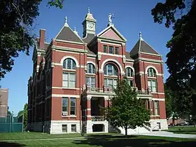 Franklin County Courthouse in Ottawa (2009) | |
 Location within the U.S. state of Kansas | |
| Coordinates: 38°35′00″N 95°17′00″W / 38.5833°N 95.2833°W | |
| Country |  United States |
| State |  Kansas |
| Founded | August 25, 1855 |
| Named after | Benjamin Franklin |
| Seat | Ottawa |
| Largest city | Ottawa |
| Area | |
• Total | 577 sq mi (1,490 km2) |
| • Land | 572 sq mi (1,480 km2) |
| • Water | 5.4 sq mi (14 km2) 0.9% |
| Population | |
• Total | 25,996 |
• Estimate (2025) | 26,299  |
| • Density | 45.4/sq mi (17.5/km2) |
| Time zone | UTC−6 (Central) |
| • Summer (DST) | UTC−5 (CDT) |
| ZIP Codes | 66042, 66067, 66076, 66078, 66079, 66080, 66092, 66095 |
| Area code | 785 |
| Congressional district | 3rd |
| Website | FranklinCoKS.org |
Franklin County is a county located in the eastern portion of the U.S. state of Kansas. Its county seat and most populous city is Ottawa.[2] As of the 2020 census, the county population was 25,996.[1] The county was named for Benjamin Franklin, a founding father of the United States. Formerly it was considered part of the Kansas City metropolitan area, but was removed in 2013.
History
Early history
For many millennia, the Great Plains of North America was inhabited by nomadic Native Americans. From the 16th century to 18th century, the Kingdom of France claimed ownership of large parts of North America. In 1762, after the French and Indian War, France secretly ceded New France to Spain, per the Treaty of Fontainebleau.
19th century
In 1802, Spain returned most of the land to France, but keeping title to about 7,500 square miles. In 1803, most of the land for modern day Kansas was acquired by the United States from France as part of the 828,000 square mile Louisiana Purchase for 2.83 cents per acre.
The area was included in a treaty ceding land to the Osage Nation in 1808, and ceded back to the federal government in 1825. After 1825 and prior to 1867, treaties with various Indian nations set off parts of what was later to become Franklin County for the use of Indian tribes removed from their ancestral lands. These tribes included: Ottawa, Chippewa, Sac and Fox, Peoria, and Potawatomi.[3][4]
In 1854, the Kansas Territory was organized under the provisions of the Kansas-Nebraska Act. In 1855, Franklin County was established as one of the 33 original Kansas Territory counties created by the first Territorial Legislature of 1855.[5] The county was named after Benjamin Franklin.[6] In 1861, Kansas became the 34th U.S. state.
Geography
According to the U.S. Census Bureau, the county has a total area of 577 square miles (1,490 km2), of which 572 square miles (1,480 km2) is land and 5.4 square miles (14 km2) (0.9%) is water.[7]
Adjacent counties
- Douglas County (north)
- Johnson County (northeast)
- Miami County (east)
- Linn County (southeast)
- Anderson County (south)
- Coffey County (southwest)
- Osage County (west)
Demographics
| Census | Pop. | Note | %± |
|---|---|---|---|
| 1860 | 3,030 | — | |
| 1870 | 10,385 | 242.7% | |
| 1880 | 16,797 | 61.7% | |
| 1890 | 20,279 | 20.7% | |
| 1900 | 21,354 | 5.3% | |
| 1910 | 20,884 | −2.2% | |
| 1920 | 21,946 | 5.1% | |
| 1930 | 22,024 | 0.4% | |
| 1940 | 20,889 | −5.2% | |
| 1950 | 19,928 | −4.6% | |
| 1960 | 19,548 | −1.9% | |
| 1970 | 20,007 | 2.3% | |
| 1980 | 22,062 | 10.3% | |
| 1990 | 21,994 | −0.3% | |
| 2000 | 24,784 | 12.7% | |
| 2010 | 25,992 | 4.9% | |
| 2020 | 25,996 | 0.0% | |
| 2025 (est.) | 26,299 | [8] | 1.2% |
| U.S. Decennial Census[9] 1790–1960[10] 1900–1990[11] 1990–2000[12] 2010-2020[1] | |||
Franklin County comprises the Ottawa, KS Micropolitan Statistical Area, which is included in the Kansas City-Overland Park-Kansas City, MO-KS Combined Statistical Area.
2020 census
As of the 2020 census, the county had a population of 25,996. The median age was 40.2 years, with 23.3% of residents under the age of 18 and 18.1% aged 65 years or older.[13]
For every 100 females there were 99.7 males, and for every 100 females age 18 and over there were 98.8 males age 18 and over. 47.9% of residents lived in urban areas, while 52.1% lived in rural areas.[13][14]
The racial makeup of the county was 89.2% White, 1.2% Black or African American, 0.8% American Indian and Alaska Native, 0.4% Asian, 0.0% Native Hawaiian and Pacific Islander, 1.5% from some other race, and 6.9% from two or more races. Hispanic or Latino residents of any race comprised 4.4% of the population.[15]
There were 10,233 households in the county, of which 30.3% had children under the age of 18 living with them and 23.4% had a female householder with no spouse or partner present. About 26.8% of all households were made up of individuals and 12.2% had someone living alone who was 65 years of age or older.[13]
There were 11,149 housing units, of which 8.2% were vacant. Among occupied housing units, 69.7% were owner-occupied and 30.3% were renter-occupied. The homeowner vacancy rate was 2.0% and the rental vacancy rate was 6.4%.[13]
2000 census
As of the U.S. Census in 2000,[16] there were 24,784 people, 9,452 households, and 6,720 families residing in the county. The population density was 43 people per square mile (17 people/km2). There were 10,229 housing units at an average density of 18 per square mile (6.9/km2). The racial makeup of the county was 95.05% White, 1.21% Black or African American, 0.94% Native American, 0.31% Asian, 0.78% from other races, and 1.71% from two or more races. Hispanic or Latino of any race were 2.62% of the population.
There were 9,452 households, out of which 34.70% had children under the age of 18 living with them, 58.10% were married couples living together, 8.90% had a female householder with no husband present, and 28.90% were non-families. 24.80% of all households were made up of individuals, and 11.30% had someone living alone who was 65 years of age or older. The average household size was 2.56 and the average family size was 3.04.
In the county, the population was spread out, with 27.50% under the age of 18, 8.90% from 18 to 24, 28.30% from 25 to 44, 21.20% from 45 to 64, and 14.00% who were 65 years of age or older. The median age was 36 years. For every 100 females there were 98.30 males. For every 100 females age 18 and over, there were 94.10 males.
The median income for a household in the county was $39,052, and the median income for a family was $45,197. Males had a median income of $31,223 versus $22,992 for females. The per capita income for the county was $17,311. About 5.60% of families and 7.70% of the population were below the poverty line, including 8.40% of those under age 18 and 7.30% of those age 65 or over.
Government and politics
| Year | Republican | Democratic | Third party(ies) | |||
|---|---|---|---|---|---|---|
| No. | % | No. | % | No. | % | |
| 1888 | 2,422 | 50.47% | 1,113 | 23.19% | 1,264 | 26.34% |
| 1892 | 2,209 | 46.06% | 0 | 0.00% | 2,587 | 53.94% |
| 1896 | 2,609 | 44.91% | 3,152 | 54.25% | 49 | 0.84% |
| 1900 | 2,872 | 51.55% | 2,605 | 46.76% | 94 | 1.69% |
| 1904 | 2,855 | 62.84% | 1,310 | 28.84% | 378 | 8.32% |
| 1908 | 2,658 | 52.74% | 2,155 | 42.76% | 227 | 4.50% |
| 1912 | 672 | 13.75% | 1,970 | 40.29% | 2,247 | 45.96% |
| 1916 | 3,885 | 45.17% | 4,128 | 47.99% | 588 | 6.84% |
| 1920 | 5,216 | 65.16% | 2,606 | 32.55% | 183 | 2.29% |
| 1924 | 6,008 | 67.05% | 2,324 | 25.94% | 628 | 7.01% |
| 1928 | 7,346 | 78.40% | 1,951 | 20.82% | 73 | 0.78% |
| 1932 | 4,887 | 50.16% | 4,690 | 48.14% | 165 | 1.69% |
| 1936 | 6,007 | 57.00% | 4,503 | 42.73% | 28 | 0.27% |
| 1940 | 6,393 | 63.80% | 3,542 | 35.35% | 85 | 0.85% |
| 1944 | 5,375 | 64.68% | 2,880 | 34.66% | 55 | 0.66% |
| 1948 | 5,145 | 58.24% | 3,467 | 39.25% | 222 | 2.51% |
| 1952 | 6,983 | 72.86% | 2,532 | 26.42% | 69 | 0.72% |
| 1956 | 6,557 | 71.42% | 2,591 | 28.22% | 33 | 0.36% |
| 1960 | 6,158 | 68.20% | 2,824 | 31.28% | 47 | 0.52% |
| 1964 | 3,725 | 45.31% | 4,410 | 53.64% | 86 | 1.05% |
| 1968 | 4,875 | 59.17% | 2,524 | 30.63% | 840 | 10.20% |
| 1972 | 6,011 | 72.71% | 2,056 | 24.87% | 200 | 2.42% |
| 1976 | 4,760 | 55.49% | 3,607 | 42.05% | 211 | 2.46% |
| 1980 | 5,525 | 62.73% | 2,726 | 30.95% | 557 | 6.32% |
| 1984 | 6,284 | 70.61% | 2,523 | 28.35% | 92 | 1.03% |
| 1988 | 4,777 | 56.43% | 3,592 | 42.43% | 96 | 1.13% |
| 1992 | 3,699 | 37.43% | 2,968 | 30.03% | 3,216 | 32.54% |
| 1996 | 5,007 | 50.91% | 3,552 | 36.12% | 1,276 | 12.97% |
| 2000 | 5,925 | 61.35% | 3,321 | 34.39% | 412 | 4.27% |
| 2004 | 7,391 | 64.40% | 3,921 | 34.17% | 164 | 1.43% |
| 2008 | 7,079 | 60.04% | 4,433 | 37.60% | 279 | 2.37% |
| 2012 | 6,984 | 63.55% | 3,694 | 33.61% | 312 | 2.84% |
| 2016 | 7,185 | 65.53% | 2,892 | 26.37% | 888 | 8.10% |
| 2020 | 8,479 | 67.96% | 3,690 | 29.57% | 308 | 2.47% |
| 2024 | 8,773 | 69.04% | 3,676 | 28.93% | 259 | 2.04% |
| Voter Registration by County as of June 2026[20] | |||||
|---|---|---|---|---|---|
| Party | Number of Voters | Percentage | |||
| Democratic | 3,209 | 16.61% | |||
| Libertarian | 244 | 0.01% | |||
| Republican | 10,472 | 54.21% | |||
| Others | 5,391 | 27.91% | |||
| Total | 19,316 | 100% | |||
Government
At the federal level, Franklin County is represented in the United States Senate by Jerry Moran and Roger Marshall, both Republicans. It is represented in the United States House of Representatives as part of Kansas's 2nd congressional district by Republican Derek Schmidt. At the state level, Franklin County is in the Kansas Senate's 12th district, represented by Republican Caryn Tyson. It is largely in the Kansas House of Representatives's 59th district, represented by Republican Rebecca Schmoe, with a small portion lying in the 5th district, represented by Republican Courtney Sappington. Judicially, Franklin County is within the 4th district court district. It also has a board of county commissioners and several elected county officials.
| Office | Name | Party | |
|---|---|---|---|
| Commissioner, District 1 | Colton Waymire | Republican | |
| Commissioner, District 2 | Rod Harris | Republican | |
| Commissioner, District 3 | Sabrina Meador | Republican | |
| Commissioner, District 4 | Scott Hornbuckle | Republican | |
| Commissioner, District 5 | Donald Stottlemire | Republican | |
Politics
Historically a Free-Stater stronghold with unionist sympathies (Franklin County was the site of the infamous Pottawatomie massacre)[21], Franklin County, like most of the state, voted strongly Republican throughout most of the 19th century. Suffering from severe drought and a national economic downturn in the late 19th century, the county began voting for populist candidates and was the home base of Peter Percival Elder, a Republican who later became a state house speaker under the Farmers' Alliance, which evolved into the Populist Party.[22] Franklin County continued to deliver strong majorities to populist candidates until the 1920s, when it, like the rest of the state, shifted heavily towards the Republican Party. Since then, Franklin County has been a Republican stronghold, being one of few Kansas counties to never vote for Franklin D. Roosevelt in any of his four runs. Aside from 1964, when the county was won by Lyndon B. Johnson amidst a national landslide, the county has voted continuously for Republicans since 1920, and Republicans have improved their margins in every election since 2008.
Transportation
Airport
The county contains one airport, Ottawa Municipal Airport. The airport is civilian use.
Major highways


Education
Unified school districts
School districts include:[23]
- West Franklin USD 287
- Central Heights USD 288
- Wellsville USD 289
- Ottawa USD 290
- Baldwin City USD 348
- Garnett USD 365
- Marais des Cygnes Valley USD 456
- Santa Fe Trail USD 434
- Paola USD 368
- Lebo-Waverly USD 243
Colleges and universities
- Ottawa University, Ottawa
- Neosho County Community College (branch campus), Ottawa
Communities

List of townships / incorporated cities / unincorporated communities / extinct former communities within Franklin County.[24]
Cities
- Lane
- Ottawa (county seat)
- Pomona
- Princeton
- Rantoul
- Richmond
- Wellsville
- Williamsburg
Unincorporated places
† means a community is designated a Census-Designated Place (CDP) by the United States Census Bureau.
Ghost towns
Townships
Franklin County is divided into sixteen townships. The city of Ottawa is considered governmentally independent and is excluded from the census figures for the townships. In the following table, the population center is the largest city (or cities) included in that township's population total, if it is of a significant size.
Notable people
- Foster Dwight Coburn, Secretary of Agriculture, Kansas
- Steve Grogan, NFL quarterback, who grew up in Ottawa.
- Chely Wright, Singer
- James Still (playwright), writer, who grew up in Pomona
- Gary Hart, Democratic US Senator
See also
- Community information for Kansas
References
- 1 2 3 "QuickFacts; Franklin County, Kansas; Population, Census, 2020 & 2010". United States Census Bureau. Archived from the original on August 16, 2021. Retrieved August 16, 2021.
- ↑ "Find a County". National Association of Counties. Archived from the original on May 31, 2011. Retrieved June 7, 2011.
- ↑ Tucker, Patrick. "When War Under Heaven Ended: Tracking Pontiac's and Atawang's Band of Odawa and Ojibwa in Ohio, Walpole Island (Canada), Kansas, and Oklahoma, 1764-1938".
- ↑ "A brief sketch of Indian tribes in Franklin County, Kansas in 1862-1906 - 23 - Kansas Memory".
- ↑ Blackmar, Frank Wilson (1912). Kansas: A Cyclopedia of State History, Embracing Events, Institutions, Industries, Counties, Cities, Towns, Prominent Persons, Etc. Standard Publishing Company. pp. 680.
- ↑ Gannett, Henry (1905). The Origin of Certain Place Names in the United States. Govt. Print. Off. pp. 131.
- ↑ "US Gazetteer files: 2010, 2000, and 1990". United States Census Bureau. February 12, 2011. Retrieved April 23, 2011.
- ↑ "County Population Totals and Components of Change: 2020-2025". United States Census Bureau. Retrieved April 14, 2026.
- ↑ "U.S. Decennial Census". United States Census Bureau. Retrieved July 24, 2014.
- ↑ "Historical Census Browser". University of Virginia Library. Retrieved July 24, 2014.
- ↑ "Population of Counties by Decennial Census: 1900 to 1990". United States Census Bureau. Retrieved July 24, 2014.
- ↑ "Census 2000 PHC-T-4. Ranking Tables for Counties: 1990 and 2000" (PDF). United States Census Bureau. Archived (PDF) from the original on March 27, 2010. Retrieved July 24, 2014.
- 1 2 3 4 "2020 Decennial Census Demographic Profile (DP1)". United States Census Bureau. 2021. Retrieved December 15, 2025.
- ↑ "2020 Decennial Census Demographic and Housing Characteristics (DHC)". United States Census Bureau. 2023. Retrieved December 15, 2025.
- ↑ "2020 Decennial Census Redistricting Data (Public Law 94-171)". United States Census Bureau. 2021. Retrieved December 15, 2025.
- ↑ "U.S. Census website". United States Census Bureau. Retrieved January 31, 2008.
- ↑ Leip, David. "Dave Leip's Atlas of U.S. Presidential Elections". uselectionatlas.org.
- ↑ Kobach, Kris (November 8, 2016). "2016 General Election Presidential Results by County". Secretary of State of Kansas. Archived from the original on February 23, 2020. Retrieved June 8, 2026.
- ↑ Schwab, Scott (November 5, 2024). "Election Results". Secretary of State of Kansas. Retrieved April 13, 2026.
- ↑ "Voter Registration Statistics". Kansas Secretary of State. Retrieved August 9, 2026.
- ↑ "Pottawatomie Massacre". civilwaronthewesternborder.org. Retrieved August 9, 2026.
- ↑ listing for the Financial History in a populist pamphlets collection
- ↑ "2020 CENSUS - SCHOOL DISTRICT REFERENCE MAP: Franklin County, KS" (PDF). U.S. Census Bureau. Retrieved November 10, 2024. - Text list
- 1 2 "General Highway Map of Franklin County, Kansas" (PDF). Kansas Department of Transportation (KDOT). October 2009. Archived (PDF) from the original on May 18, 2024.
- Notes
Further reading
- Franklin County: Its Past, Its Present & Its Coming Future; Queen City Printing Co; 1983.
- Reflections of Franklin County & Chautauqua Days; Franklin County Centennial Committee; Franklin County Historical Society; 1961.
- Standard Atlas of Franklin County, Kansas; Geo. A. Ogle & Co; 69 pages; 1920.
- Plat Book of Franklin County, Kansas; North West Publishing Co; 36 pages; 1903.
External links

- County
- Historical
- Franklin County Genealogical Society Archived February 6, 2017, at the Wayback Machine
- Maps
- Historic County Township Boundary Maps - Kansas Department of Transportation
- Historic County Road Maps - Kansas Department of Transportation
- Historic State Highway Maps - Kansas Department of Transportation
- Historic State Railroad Maps: 1996, 1929, 1915, 1907 - Kansas Historical Society
Places adjacent to Franklin County, Kansas | ||||||||||||||||
|---|---|---|---|---|---|---|---|---|---|---|---|---|---|---|---|---|
| ||||||||||||||||


Municipalities and communities of Franklin County, Kansas, United States | ||
|---|---|---|
| Cities | | |
| CDP | ||
| Unincorporated communities | ||
| Ghost towns | ||
| Townships | ||
| Footnotes | †This community is designated a Census-Designated Place (CDP) by the United States Census Bureau. | |