Escornebœuf
Escornebœuf | |
|---|---|
 The town hall in Escornebœuf | |
Location of Escornebœuf | |
  Escornebœuf Location within France  Escornebœuf Location within Occitanie | |
| Coordinates: 43°39′21″N 0°54′45″E / 43.6558°N 0.9125°E | |
| Country | France |
| Region | Occitania |
| Department | Gers |
| Arrondissement | Auch |
| Canton | Gimone-Arrats |
| Government | |
| • Mayor (2020–2026) | Sergine Ageorges[1] |
Area 1 | 25.45 km2 (9.83 sq mi) |
| Population (2023)[2] | 579 |
| • Density | 22.8/km2 (58.9/sq mi) |
| Time zone | UTC+01:00 (CET) |
| • Summer (DST) | UTC+02:00 (CEST) |
| INSEE/Postal code | 32123 /32200 |
| Elevation | 135–232 m (443–761 ft) (avg. 153 m or 502 ft) |
| 1 French Land Register data, which excludes lakes, ponds, glaciers > 1 km2 (0.386 sq mi or 247 acres) and river estuaries. | |
Escornebœuf (French pronunciation: [ɛskɔʁnəbœf]; Occitan: Escòrnabueu) is a commune in the Gers department in southwestern France.
Geography
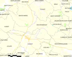
The commune is primarily rural, with agriculture being the main economic activity. The surrounding countryside features vineyards, grain fields, and livestock farming.
Population
| Year | Pop. | ±% p.a. |
|---|---|---|
| 1968 | 434 | — |
| 1975 | 403 | −1.05% |
| 1982 | 383 | −0.72% |
| 1990 | 473 | +2.67% |
| 1999 | 497 | +0.55% |
| 2007 | 473 | −0.62% |
| 2012 | 508 | +1.44% |
| 2017 | 565 | +2.15% |
| 2023 | 579 | +0.41% |
| Source: INSEE[3] | ||
See also
References
- ↑ "Répertoire national des élus: les maires". data.gouv.fr, Plateforme ouverte des données publiques françaises (in French). 2 December 2020.
- ↑ "Populations de référence 2023" (in French). National Institute of Statistics and Economic Studies. 18 December 2025.
- ↑ Population municipale entre 1968 et 2023, INSEE

Wikimedia Commons has media related to Escornebœuf.

Categories: