East Branch Croton River
| East Branch Croton River | |
|---|---|
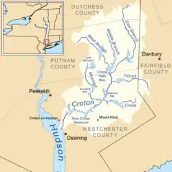 Map of the Croton River watershed showing the East Branch to the northeast | |
| Location | |
| Country | United States |
| State | New York |
| Counties | Dutchess, Putnam, Westchester |
| Physical characteristics | |
| Source | |
| • location | near Pawling |
| • coordinates | 41°33′50″N 73°34′23″W / 41.56379°N 73.57310°W[1] |
| Mouth | confluence with West Branch Croton River |
• location | near Croton Falls |
• coordinates | 41°20′49″N 73°39′51″W / 41.34698°N 73.66421°W[2] |
| Basin features | |
| Progression | Croton → Hudson → New York Harbor |
| River system | Croton River watershed |
| Cities | |
| Waterbodies | |
The East Branch Croton River is a tributary of the Croton River in Dutchess, Putnam, and Westchester counties in the state of New York. It lies within the Croton River watershed and is part of the New York City water supply system's Croton Watershed.[3]
Path
The river rises in the town of Pawling in Dutchess County, flowing west and then south through the village of Pawling. It crosses into Putnam County, flowing through the Great Swamp in the town of Patterson. It then flows south, west and southwest through the town of Southeast, passing through the East Branch Reservoir, the village of Brewster, and the Diverting Reservoir. Finally, it crosses into Westchester County, joining the West Branch Croton River at the hamlet of Croton Falls in North Salem to form the main Croton River.
See also
References
- ↑ "Node: 8813224191". OpenStreetMap. Retrieved 20 July 2026.
- ↑ "Node: 11540771760". OpenStreetMap. Retrieved 20 July 2026.
- ↑ "Map of the Croton Watershed, at New York City Department of Environmental Protection". Archived from the original on 2019-02-21. Retrieved 2019-02-27.