Administrative divisions of Myanmar
| Administrative divisions of Myanmar | |
|---|---|
 | |
| Category | Unitary state |
| Location | Republic of the Union of Myanmar |
| Number | 7 regions 7 states 1 union territory (as of 2024) |
| Populations | 286,627 (Kayah State) - 7,360,703 (Yangon Region) |
| Areas | 7,054 km2 (2,724 sq mi) (Naypyidaw Union Territory) - 155,801 km2 (60,155 sq mi) (Shan State) |
| Government | |
| Subdivisions | |
| Administrative divisions of Myanmar |
|---|
| First level |
| Sub-first level |
| Second level |
| Third level |
| Fourth level |
| Fifth level |
According to the 2008 Constitution, the Republic of the Union of Myanmar constitutes seven regions, seven states and one union territory.[1] The constitution also mentions one self-administered division and five self-administered zones which are parts of some of the states and regions.[1] In addition to these constitutional administrative subdivisions, there are also extraconstitutional special regions controlled by ethnic armed groups which recognize the central government's sovereignty after the cease-fire agreements of 1989 and 1990s.[2]
Structural hierarchy
| Union level | ||||
|---|---|---|---|---|
| The Republic of the Union | ||||
| First level | ||||
| Union Territory | State | Region | ||
| Second level | ||||
| District | City | Special Region | Self-Administered Division | Self-Administered Zone |
| District | ||||
| Third level | ||||
| Township | Township | |||
| Subtownship | ||||
| Local level | ||||
| Ward | Village Tract | Town | ||
| Village | Ward | |||
The regions were called divisions prior to August 2010,[3] and four of them are named after their capital city, the exceptions being Sagaing Region, Ayeyarwady Region and Tanintharyi Region. The regions can be described as ethnically predominantly Burman (Bamar), while the states are dominated by ethnic minorities.
Regions and states are made up of districts, as well as self-administered zones and self-administered divisions if they exist.[1] The self-administered divisions are also constituted by districts. The districts and the self-administered zones consist of townships that include towns, wards and village tracts. Village tracts are groups of adjacent villages.
Yangon Region has the largest population and is the most densely populated. The smallest population is Kayah State. In terms of land area, Shan State is the largest and Naypyidaw Union Territory is the smallest.
The self-administered division (SAD) exists at an administrative level half-a-step below that of states, regions and the union territory, and the self-administrative zones (SAZ) exists at the district level.[4] The self-administered areas were formed by statutes on territory controlled by Myanmar's ethnic armed organisations.[5]
Within the hierarchy, the most significant unit of local governance below the first level is the township which form the a consistent set of administrative units across the country. Often, local governance will go directly from the township to the ward. Most of the country do not have separate town offices. For example, in 2015, only 7 of the 27 townships of Ayeyarwady Region had a town office at all.[6]
Additionally, some townships are divided into Subtownships (မြို့နယ်ခွဲ), which are semi-official parts of a township administered separately, often revolving around a town separate from the township's principal town. Many reports will use subtownships, especially more established subtownships used by the main townships themselves.[7]
The extraconstitutional cities of Yangon, Mandalay and Nay Pyi Taw are defined by development committee law. The territories of each city development committee contain multiple districts, below the city. In the cities of Yangon and Mandalay, township development committees are de jure subdivisions of the city development committee, without a district level.[8][9]
System of administration

The administrative structure of the states, regions and self-administering bodies is outlined in the new constitution adopted in 2008.[1]
Regions, States and Union Territories
| Flag | Name | Burmese | Capital | ISO | Region | Pop. (2024)[10] |
Area (km2) |
Density (per km2) |
|---|---|---|---|---|---|---|---|---|
 |
Ayeyarwady Region | ဧရာဝတီတိုင်းဒေသကြီး | Pathein | MM-07 | Lower | 5,546,415 | 35,031.9 | 158.3 |
 |
Bago Region | ပဲခူးတိုင်းဒေသကြီး | Bago | MM-02 | Lower | 4,453,687 | 39,404.5 | 113.02 |
 |
Chin State | ချင်းပြည်နယ် | Hakha | MM-14 | Upper | 373,023 | 36,018.9 | 10.4 |
 |
Kachin State | ကချင်ပြည်နယ် | Myitkyina | MM-11 | Upper | 2,153,483 | 89,041.9 | 24.2 |
 |
Kayah State | ကယားပြည်နယ် | Loikaw | MM-12 | Upper | 296,901 | 11,731.5 | 25.3 |
 |
Kayin State | ကရင်ပြည်နယ် | Hpa-an | MM-13 | Lower | 1,502,774 | 30,382.8 | 49.5 |
 |
Magway Region | မကွေးတိုင်းဒေသကြီး | Magwe | MM-03 | Upper | 4,077,653 | 44,820.6 | 91.0 |
 |
Mandalay Region | မန္တလေးတိုင်းဒေသကြီး | Mandalay | MM-04 | Upper | 6,323,554 | 30,888.1 | 204.7 |
 |
Mon State | မွန်ပြည်နယ် | Mawlamyine | MM-15 | Lower | 2,054,393 | 12,296.6 | 149.0 |
 |
Naypyidaw Union Territory | နေပြည်တော် ပြည်ထောင်စုနယ်မြေ | Naypyidaw | MM-18 | Upper | 1,129,322 | 7,057.1 | 160.0 |
 |
Rakhine State | ရခိုင်ပြည်နယ် | Sittwe | MM-16 | Lower | 2,526,792 | 36,778.1 | 68.7 |
 |
Sagaing Region | စစ်ကိုင်းတိုင်းဒေသကြီး | Monywa | MM-01 | Upper | 5,977,292 | 93,702.5 | 63.8 |
 |
Shan State | ရှမ်းပြည်နယ် | Taunggyi | MM-17 | Upper | 6,412,501 | 155,801.5 | 41.2 |
 |
Tanintharyi Region | တနင်္သာရီတိုင်းဒေသကြီး | Dawei | MM-05 | Lower | 1,399,965 | 43,344.9 | 32.3 |
 |
Yangon Region | ရန်ကုန်တိုင်းဒေသကြီး | Yangon | MM-06 | Lower | 7,369,989 | 10,276.7 | 717.2 |
Executive authority is held in each state or region by a Regional or State Government consisting of a Chief Minister, other ministers and an Advocate General.[1] The President appoints the Chief Minister from a list of qualified candidates in the regional or state legislature; the legislature must approve this choice unless it is proven that the candidate does not meet constitutional qualifications.[1] Since 4th March 2026, the Region or State minister responsible for development affairs is appointed as the mayor for the capital of the respective Region or State.[11]
Legislative authority resides with the State Hluttaw or Region Hluttaw made up of elected civilian members and representatives of the Armed Forces. Both divisions are considered equivalent, the only distinction being that states have large ethnic minority populations and regions are mostly populated by the national majority Burmans / Bamar.[12]
Naypyidaw Union Territory
The constitution states that Naypyidaw shall be a Union Territory under the direct administration of the President. Day-to-day functions would be carried out on the President's behalf by the Naypyidaw Council led by a Chairperson. The Chairperson and members of the Naypyidaw Council are appointed by the President and shall include civilians and representatives of the Armed Forces.
Self-Administered Division and Self-Administered Zones

| Flag | Name | Burmese | Capital | State | Population |
|---|---|---|---|---|---|
 |
Danu Self-Administered Zone | ဓနုကိုယ်ပိုင်အုပ်ချုပ်ခွင့်ရဒေသ | Pindaya | Shan State | 161,835 |
 |
Kokang Self-Administered Zone | ကိုးကန့်ကိုယ်ပိုင်အုပ်ချုပ်ခွင့်ရဒေသ | Laukkai | Shan State | 123,733 |
 |
Naga Self-Administered Zone | နာဂကိုယ်ပိုင်အုပ်ချုပ်ခွင့်ရဒေသ | Lahe | Sagaing Region | 116,828 |
 |
Pa Laung Self-Administered Zone | ပလောင်းကိုယ်ပိုင်အုပ်ချုပ်ခွင့်ရဒေသ | Namhsan | Shan State | 110,805 |
 |
Pa'O Self-Administered Zone | ပအိုဝ့်ကိုယ်ပိုင်အုပ်ချုပ်ခွင့်ရဒေသ | Hopong | Shan State | 380,427 |
 |
Wa Self-Administered Division | ဝကိုယ်ပိုင်အုပ်ချုပ်ခွင့်ရတိုင်း | Hopang | Shan State | 558,000 |
Self-Administered Zones and Self-Administered Divisions are subdivisions of some of the states and regions. Self-administered zones are equivalent to the administrative level of districts while the self-administered division is above the district level. Each of them is administered by a Leading Body consisting of at least ten members and includes State or Regional Hluttaw members elected from the Zones or Divisions and other members nominated by the Armed Forces. The Leading Body has both executive and legislative powers. A Chairperson is head of each Leading Body.
Within Sagaing Region:[13]
- Naga Self-Administered Zone (Leshi, Lahe, and Namyun townships)
Within Shan State:
- Danu Self-Administered Zone (Ywangan and Pindaya townships),
- Kokang Self-Administered Zone (Konkyan and Laukkai townships)
- Pa Laung Self-Administered Zone (Namshan and Manton townships)
- Pa'O Self-Administered Zone (Hopong, Hshihseng, and Pinlaung townships),
- Wa Self-Administered Division (Hopang, Mongmao, Panwai, Pangsang, Naphan, and Metman townships)
Special Regions
Special Regions refer to areas not under the control of the central government that are co-administerd by an ethnic armed organisations under ceasefire agreements.[14] These regions were first formed in 1989 and through the 1990s under the State Peace and Development Council. The special regions are numbered and are as follows:[15]
- Kachin State
- Kachin State Special Region 1 (New Democratic Army – Kachin, 1989-2024) covering Chipwi District[16]
- Kachin State Special Region 2 (Kachin Independence Organisation, 1994-2011)[17]
- Shan State
- Shan State Special Region 1 (Kokang, 1989 - present, overlaps with Kokang SAZ)[14]
- Shan State Special Region 2 (Wa State, 1989 - present, overlaps with Wa SAD)[18]
- Shan State Special Region 3 (Shan State Progress Party, 1989 - present) [19]
- Shan State Special Region 4 (National Democratic Alliance Army, 1989 - present)
- Shan State Special Region 5 (Kachin Defense Army, 1991 - 2023)[20]
- Shan State Special Region 6 (Pa-O National Organisation, 1991 - present, overlaps with Pa'O SAZ)[21]
- Shan State Special Region 7 (Palaung State Liberation Army), 1991 - 2009, overlaps with Palaung SAZ)[22]
- Kayah State[23]
- Kayah State Special Region 1 (Kayan National Guard, 1992 - present)
- Kayah State Special Region 2 (Karenni National People's Liberation Front, 1994 - present)
- Kayah State Special Region 3 (Kayan New Land Party, 1994 - present)
The special regions in Shan State are often further distinguished by cardinal direction, such as Eastern Shan State Special Region 4 or Wa Special Region 2.
Districts and Townships
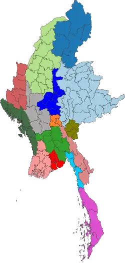
Districts are the second-order divisions of Myanmar and are often named after a population center within the district of the same name. Shan State has the most districts, even excluding Self-Administered Zones and Divisions. Naypyidaw Union Territory, Tanintharyi and Mon State have the least with just 4 districts.[24] The District's role is more supervisory as the 330 townships are the basic administrative unit of local governance and are the only type of administrative division that covers the entirety of Myanmar. A District is led by a District Administrator and a Township is administered by a Township Administrator. Both are appointed civil servants through the General Administration Department (GAD) of the Ministry of Home Affairs (MOHA). The Minister of Home Affairs is to be appointed by the military according to the 2008 constitution.[25] The 2008 Constitution of Myanmar defined 75 districts. In April 2022, 46 additional districts were formed by MOHA bringing the total up to 121 districts.[26]
Most local governance services are offered at the Township level; few services are offered at the District level. The Township Administrator is the key focal point for most interactions with the government and the Township Administrator serves as a representative of the State or Region government and executes functions on behalf of the State or Region.[25] All Township governments are staffed by 34 GAD civil servants regardless of population, although larger townships may have several Township committees that coordinate with the Township and report to the District.[6] Subtownships exist for many but not all townships. They can be created for many reasons including, townships with large areas, townships with a large natural barrier or townships with a lopsided population distribution. These subtownships are unofficial, but can be used by the Township administration and national ministries for data collection and administrative ease.
Cities and Development Committees
The definition of a city or a town is ambiguous with the Burmese term မြို့ ("myo") being translated as any urban area. The term မြို့တော် ("myodaw"; royal myo) is used for a city to distinguish from a mere town. The General Administration Department only explicitly defines the three cities of Yangon, Mandalay and Naypyidaw.[27] The municipality is functionally administered at the city level with townships acting as subdivisions of the city in Yangon and Mandalay according to the development laws of each city.[8][9] In Yangon, the administrative jurisdiction of the Yangon City Development Committee overlap across 34 townships.[28][29] While the city of Yangon exists de facto, as the boundaries determined by the Yangon City Development Committee, the de jure relationship is between township development committees and the city development committee.[8] The city of Mandalay, in contrast, is slightly more defined in law, establishing a "city" with boundaries and constituent townships in its development law.[9]
Prior to the expansion of districts in 2022, the city of Mandalay was functionally administered at the Mandalay District level with townships acting de facto as subdivisions of a city.[30] The city of Yangon overlapped with all four pre-2022 districts.[28]
Towns / Village Tracts and Wards / Villages
Other settlements colloquially called "cities" are considered towns in Myanmar. All towns are contained within one township like Pathein. In some cases, the rural portions of the township centred on a different town may be administered semi-independently as sub-townships.[31]
The lowest level of practical administration is the ward for urban areas and village for rural areas. Villages are grouped into and administered as village tracts.[4] Village Tracts may contain up to 8 distinct villages. Some townships include areas not part of any ward or village tract. Most townships contain at least one ward/town, and are usually named after the population center. As of reforms in 2012 and 2013, Ward and Village Tract administrators are now typically elected, but report to the appointed Township Administrator. Ward Administrators and Village Tract Administrators (also called just Village Administrators) are supported by 100-household-heads and 10-household-heads who are collectively called area leaders.[6]
History
British colonisation
In 1900, Burma was a province of British India, and was divided into two subdivisions: Lower Burma, whose capital was Rangoon with four divisions (Arakan, Irrawaddy, Pegu, Tenasserim), and Upper Burma, whose capital was Mandalay with six divisions (Meiktila, Minbu, Sagaing, North Federated Shan States and South Federated Shan States).
On 10 October 1922, the Karenni States of Bawlake, Kantarawaddy, and Kyebogyi became a part of the Federated Shan States. In 1940, Minbu division's name was changed to Magwe, and Meiktila Divisions became part of Mandalay District.
Post-independence
Upon independence, on 4 January 1948, the Chin Hills area was split from Arakan Division to form Chin Special Division, and Kachin State was formed by carving out the Myitkyina and Bhamo districts of Mandalay Division. Karen State was also created from Amherst, Thaton, and Toungoo Districts of Tenasserim Division. Mongpai State of the Federated Shan States was separated to form Karenni State, and Shan State was formed by merging the other Federated Shan States and the Wa States.
In 1952, Karenni State was renamed Kayah State. Preparing since 1951, Karen State was officially founded in 1954. In 1964, Rangoon Division was separated from Pegu Division, whose capital shifted to Pegu. In addition, Karen State was renamed as Kawthoolei.
In 1972, the Hanthawaddy and Hmawbi districts were moved under Rangoon Division's jurisdiction. Tenasserim Division was divided into two separate divisions: Moulmein District and Thaton District came under the Tenasserim Division (1) with Moulmein as the capital, and Myeik District and Tavoy District constituted the Tenasserim Division (2) with Tavoy becoming its capital.[32]
The present-day structure of seven states and seven divisions was adopted after the coming into force of the 1974 Constitution. Chin Special Division became Chin State, and its capital moved from Falam to Hakha. The name of Kawthoolei was reverted to Karen State. Tenasserim Division (1) gained statehood as Mon State, whereas Tenasserim Division (2) became the only Tenasserim Division. In addition, Arakan Division was granted statehood as Arakan State. Notably, the district level was abolished and townships were put directly below the level of states and divisions.
After the coup d'état by the State Law and Order Restoration Council military junta in 1988, the new level of township zones was introduced between the level of state and divisions and the township level. In 1989, the names of many divisions in Burma were altered in English to reflect Burmese pronunciations.[33] The township zones were redefined as districts in 1992. In 1994, a new level of sub-states and sub-divisions were introduced between the level of states and divisions and the district level.
From 1989 onward, the military government granted the status of special regions to the territories controlled by some (not all) of the ethnic armed groups which entered into cease-fire agreement with the government. After 1995, in Kachin State Mohnyin District was created out of Myitkyina District as part of the peace agreement with the Kachin Independence Army.
2008 Constitution
The 2008 Constitution stipulates the renaming of the 7 "divisions" (တိုင်း in Burmese) as "regions" (တိုင်းဒေသကြီး in Burmese). It also stipulates the creation of Union territory which includes the capital Nay Pyi Taw with the same level as the states and regions, and the ethnic self-administered zones (ကိုယ်ပိုင်အုပ်ချုပ်ခွင့်ရဒေသ in Burmese) and self-administered divisions (ကိုယ်ပိုင်အုပ်ချုပ်ခွင့်ရတိုင်း in Burmese) which are the subdivisions of states and regions.[1] These self-administered regions include the following:
- Danu Self-Administered Zone: consisting of Ywangan and Pindaya townships in Shan State
- Kokang Self-Administered Zone: consisting of Konkyan and Laukkai townships in Shan State
- Naga Self-Administered Zone: consisting of Leshi, Lahe, and Namyun townships in Sagaing Region
- Pa Laung Self-Administered Zone: consisting of Namhsan and Manton townships in Shan State
- Pa-O Self-Administered Zone: consisting of Hopong, Hsihseng, and Pinlaung townships in Shan State
- Wa Self-Administered Division: consisting of Hopang, Mongmao, Panwai, Nahpan, Metman, and Pangsang (Pankham) townships in Shan State
On 20 August 2010, the renaming of the 7 divisions and the naming of the 6 self-administered zones was announced by Burmese state media.[3]
Evolution and changes in hierarchy
Historical evolution of states/regions
Below is a summary of how Myanmar's first-level administrative divisions have evolved since independence:
| 1948–1952 | 1952–1954 | 1954–1964 | 1964–1972 | 1972–1974 | 1974–1989 | 1989–2011 | 2011–present |
|---|---|---|---|---|---|---|---|
| [34][35] | [36] | [37] | [32] | [38][34] | [39] | [1][40] | |
| Kachin State | Kachin State | Kachin State | Kachin State | Kachin State | Kachin State | Kachin State | Kachin State |
| Shan State | Shan State | Shan State | Shan State | Shan State | Shan State | Shan State | Shan State |
| Karenni State | Kayah State | Kayah State | Kayah State | Kayah State | Kayah State | Kayah State | Kayah State |
| Chin Special Division | Chin Special Division | Chin Special Division | Chin Special Division | Chin Special Division | Chin State | Chin State | Chin State |
| Arakan Division | Arakan Division | Arakan Division | Arakan Division | Arakan Division | Arakan State | Rakhine State | Rakhine State |
| Tenasserim Division | Tenasserim Division | Karen State | Kawthoolei | Kawthoolei | Karen State | Kayin State | Kayin State |
| Tenasserim Division | Tenasserim Division | Tenasserim Division (1) | Mon State | Mon State | Mon State | ||
| Tenasserim Division (2) | Tenasserim Division | Tanintharyi Division | Tanintharyi Region | ||||
| Pegu Division | Pegu Division | Pegu Division | Pegu Division | Pegu Division | Pegu Division | Bago Division | Bago Region |
| Rangoon Division | Rangoon Division | Rangoon Division | Yangon Division | Yangon Region | |||
| Irrawaddy Division | Irrawaddy Division | Irrawaddy Division | Irrawaddy Division | Irrawaddy Division | Irrawaddy Division | Ayeyarwady Division | Ayeyarwady Region |
| Magwe Division | Magwe Division | Magwe Division | Magwe Division | Magwe Division | Magwe Division | Magway Division | Magway Region |
| Sagaing Division | Sagaing Division | Sagaing Division | Sagaing Division | Sagaing Division | Sagaing Division | Sagaing Division | Sagaing Region |
| Mandalay Division | Mandalay Division | Mandalay Division | Mandalay Division | Mandalay Division | Mandalay Division | Mandalay Division | Mandalay Region |
| Nay Pyi Taw Union Territory |
Historical changes in hierarchy
| 1974–1988 | 1988–1989 | 1989–1992 | 1992–1994 | 1994–2011 | 2011–present | ||||||||||||||||||||
|---|---|---|---|---|---|---|---|---|---|---|---|---|---|---|---|---|---|---|---|---|---|---|---|---|---|
| [38][40] | [40] | [40] | [40] | [40] | [1][40] | ||||||||||||||||||||
| The State | The State | The State | The State | The State | The Republic | ||||||||||||||||||||
| First level | First level | First level | First level | First level | First level | ||||||||||||||||||||
| State | Division | State | Division | State | Division | State | Division | State | State | Division | Division | Union Territory | State | Region | |||||||||||
| Sub-State | Sub-Division | ||||||||||||||||||||||||
| Second level | Second level | Second level | Second level | Second level | Second level | ||||||||||||||||||||
| City | Township | City | Township Zone | Special Region | City | Township Zone | Special Region | City | District | Special Region | City | District | District | City | Special Region | Self-Administered Division | Self-Administered Zone | ||||||||
| Township Zone | Township Zone | District | District | District | |||||||||||||||||||||
| Township | Third level | Third level | Third level | Third level | Third level | ||||||||||||||||||||
| Township | Township | Township | Township | Township | Township | ||||||||||||||||||||
| Subtownship | |||||||||||||||||||||||||
| Local level | Local level | Local level | Local level | Local level | Local level | ||||||||||||||||||||
| Ward | Village Tract | Town | Ward | Village Tract | Town | Ward | Village Tract | Town | Ward | Village Tract | Town | Ward | Village Tract | Town | Ward | Village Tract | Town | ||||||||
| Village | Ward | Village | Ward | Village | Ward | Village | Ward | Village | Ward | Village | Ward | ||||||||||||||
See also
Notes
References
- 1 2 3 4 5 6 7 8 9 10 Constitution of the Republic of the Union of Myanmar, 2008
- ↑ Kudo, Toshihiro (2012), China’s policy toward Myanmar: Challenges and prospects (PDF), Institute of Developing Economies-Japan External Trade Organization, retrieved 8 July 2026
- 1 2 "တိုင်းခုနစ်တိုင်းကို တိုင်းဒေသကြီးများအဖြစ် လည်းကောင်း၊ ကိုယ်ပိုင်အုပ်ချုပ်ခွင့်ရ တိုင်းနှင့် ကိုယ်ပိုင်အုပ်ချုပ်ခွင့်ရ ဒေသများ ရုံးစိုက်ရာ မြို့များကို လည်းကောင်း ပြည်ထောင်စုနယ်မြေတွင် ခရိုင်နှင့်မြို့နယ်များကို လည်းကောင်း သတ်မှတ်ကြေညာ". Weekly Eleven News (in Burmese). 20 August 2010. Retrieved 23 August 2010.
- 1 2 "Summary of the Myanmar P-Code version- 9.2 Mar 2020" (PDF). MIMU. Myanmar Information Management Unit. Retrieved 4 April 2025.
- ↑ "Asymmetrical Federalism in Myanmar: A Modern Mandala System?" (PDF). Yusof Ishak Institute. ISEAS. Retrieved 4 April 2025.
- 1 2 3 Arnold, Matthew; Ye Thu Aung; Kempel, Susanne; Kyi Pyar Chit Saw (July 2015). Municipal Governance in Myanmar: An Overview of Developmental Affairs Organisations (PDF) (Report). Asia Foundation.
- ↑ Department of Population (23 November 2017). Census Atlas Myanamr (Report). UNFPA. p. XIII.
- 1 2 3 ရန်ကုန်မြို့တော်စည်ပင်သာယာရေးဥပဒေ [Yangon City Development Law]. Yangon Region Hluttaw. 28 June 2018.
- 1 2 3 မန္တလေးမြို့တော်စည်ပင်သာယာရေးဥပဒေ [Mandalay City Development Law]. Mandalay Region Hluttaw. 23 December 2014.
- ↑ The 2024 Myanmar Population and Housing Census: The Union Report. The 2014 Myanmar Population and Housing Census. Vol. 2. Nay Pyi Taw: Ministry of Immigration and Population. October 2025. p. 15.
- ↑ "Amendment to Region or State Government Law". Myanmar Digital News. Nay Pyi Taw: News and Periodical Enterprise, Ministry of Information. 4 March 2026. Retrieved 13 April 2026.
- ↑ "Myanmar's States and Regions – The Asia Foundation" (PDF). Asiafoundation.org. Retrieved 16 January 2018.
- ↑ "Ethnic Politics in Burma: The Time for Solutions". Tni.org. 14 February 2011. Retrieved 16 January 2018.
- 1 2 "Myanmar National Democratic Alliance Army (MNDAA)". Institute for Strategy and Policy - Myanmar. January 2024.
- ↑ UNODC Global SMART programme (December 2010). Myanmar: Situation Assessment on Amphetamine-Type Stimulants (PDF) (Report).
- ↑ "KIA Captures Last Kachin BGF Battalion Headquarters". BNI Online. 2 November 2024.
- ↑ Untold Miseries: Wartime Abuses and Forced Displacement in Burma's Kachin State. Human Rights Watch. 2012. ISBN 978-1564328748.
- ↑ Ong, Andrew (2023). Stalemate: Autonomy and Insurgency on the China-Myanmar Border. Cornell University Press. p. 111-112. ISBN 978-1-5017-7071-5. JSTOR 10.7591/j.ctv2t8b78b.
- ↑ Shan State Progress Party (SSPP). Institute for Strategy and Policy - Myanmar (Report). 20 August 2025.
- ↑ "စစ်ကောင်စီလက်အောက်ခံ ကောင်းခါးပြည်သူ့စစ် KIA ထံ ဘက်ပြောင်းခိုလှုံ" [Kaung Kha People's Militia Under Military Council Defects to KIA]. Myanmar Now. 4 January 2024.
- ↑ Ko Oo (18 February 2025). "The Junta's Ethnic Allies: What Motivates EAOs Fighting for the Myanmar Military?". The Irrawaddy.
- ↑ Phyu Phyu Ko (17 May 2013). "Two Joint Ta'ang Objectives: War on Drugs and National Liberation".
- ↑ "Kayah State Profile" (PDF). UNHCR Southeast Myanmar Information Managment Unit. June 2014. p. 5.
- ↑ "Expansion of new districts in Nay Pyi Taw, regions and states according to political, administrative, economic and social development". Ministry of Information. 2 May 2022.
- 1 2 UNDP (June 2015). Mapping the State of Local Governance in Myanmar: Background and Methodology (Report). United Nations.
- ↑ "Expansion of new districts: New districts expanded in Nay Pyi Taw, regions and states". Myanmar International Television. 2 May 2022.
- ↑ Department of Population, Ministry of Labour, Immigration and Population (December 2016). THEMATIC REPORT ON MIGRATION AND URBANIZATION (PDF) (Report). UNFPA. p. 109.
{{cite report}}: CS1 maint: multiple names: authors list (link) - 1 2 "Districts in Yangon Region" (PDF). Myanmar Information Management Unit. Archived from the original (PDF) on 3 March 2019. Retrieved 13 October 2019.
- ↑ Ford, William; Owen, James; Pillai, Sunil. Insight into Urban Well-Being in Myanmar: The 2018 City Life Survey (PDF) (Report). The Asia Foundation.
- ↑ "THE CITY OF MANDALAY DEVELOPMENT LAW (1992)" (PDF). State Law and Order Restoration Council Law. 29 December 1992. Archived from the original (PDF) on 30 June 2015. Retrieved 27 June 2015.
- ↑ Pathein Township. မြို့နယ်အထွေထွေအုပ်ချုပ်ရေးဦးစီးဌာန ပုသိမ်မြို့နယ် ဒေသဆိုင်ရာအချက်လက်များ (Report). Myanmar Information Management Unit.
- 1 2 "မွန်ပြည်နယ်၏ နောက်ခံသမိုင်း" [Background history of Mon State]. Mon State Government. Archived from the original on 11 February 2017. Retrieved 18 August 2026.
- ↑ "An Introduction to the Toponymy of Burma" The Permanent Committee of Geographic Names (PCGN), United Kingdom, October 2007, accessed 18 April 2010
- 1 2 Jap, Jangai; Courtin, Constant (2022). Deciphering Myanmar's Ethnic Landscape: A Brief Historical and Ethnic Description of Myanmar's Administrative Units. International IDEA. doi:10.31752/idea.2022.57. ISBN 978-91-7671-577-2. Retrieved 12 May 2025.
- ↑ Houng Kyaw Gei (May 2016), Chin Special Division (1948-1974) (PDF), Department of History, University of Yangon
- ↑ ဆန်းနွေဦး (12 January 2020). "သာစွဌာနီ ကန္ဒရဝတီ" (in Burmese). Retrieved 26 August 2026.
- ↑ "ကရင်ပြည်နယ်နေ့ဖြစ်ပေါ်လာပုံ" [The Origin of Karen State Day]. Karen Information Center (in Burmese). 28 October 2016. Retrieved 26 August 2026.
- 1 2 Constitution of the Socialist Republic of the Union of Burma (PDF), 1974
- ↑ The Adaptation of Expressions Law. State Law and Order Restoration Council. 18 June 1989.
- 1 2 3 4 5 6 7 "အထွေထွေအုပ်ချုပ်ရေးဦးစီးဌာနသမိုင်းကြောင်း" [History of General Administration Department]. 2026. Retrieved 26 August 2026.
External links
| States |  | |
|---|---|---|
| Regions | ||
| Self-Administered Zones | ||
| Self-Administered Divisions | ||
| Union Territories | ||


