Damavand County
Damavand County
Persian: شهرستان دماوند | |
|---|---|
 The city of Damavand | |
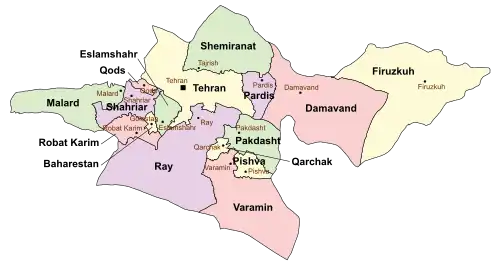 Location of Damavand County in Tehran province (right, pink) | |
 Location of Tehran province in Iran | |
| Coordinates: 35°38′N 52°13′E / 35.633°N 52.217°E[1][2] | |
| Country | Iran |
| Province | Tehran |
| Capital | Damavand |
| Districts | Central, Rudehen |
| Elevation | 2,000 m (6,600 ft) |
| Population (2016)[3] | |
• Total | 125,480 |
| Time zone | UTC+3:30 (IRST) |
| Damavand County at GEOnet Names Server | |
Damavand County (Persian: شهرستان دماوند) is in Tehran province, Iran. The capital of the county is the city of Damavand.[4]
Demographics
Population
At the time of the 2006 National Census, the county's population was 96,860 in 27,419 households.[5] The following census in 2011 counted 100,690 people in 30,060 households.[6] The 2016 census measured the population of the county as 125,480 in 39,373 households.[3]
According to the information of the State Meteorological Organization of Iran, the long-term average annual rainfall of Damavand is around 377.6 mm.[7]
Administrative divisions
Damavand County's population history and administrative structure over three consecutive censuses are shown in the following table.
| Administrative Divisions | 2006[5] | 2011[6] | 2016[3] |
|---|---|---|---|
| Central District | 69,829 | 71,359 | 84,375 |
| Abarshiveh RD | 10,059 | 11,492 | 11,567 |
| Jamabrud RD | 4,773 | 4,878 | 4,635 |
| Tarrud RD | 5,661 | 5,491 | 6,263 |
| Absard (city) | 9,865 | 9,202 | 10,648 |
| Damavand (city) | 36,433 | 37,315 | 48,380 |
| Kilan (city) | 3,038 | 2,981 | 2,882 |
| Rudehen District | 27,031 | 29,330 | 41,104 |
| Abali RD | 2,047 | 2,537 | 2,902 |
| Mehrabad RD | 2,842 | 2,794 | 6,911 |
| Abali (city) | 2,607 | 2,522 | 2,758 |
| Rudehen (city) | 19,535 | 21,477 | 28,533 |
| Total | 96,860 | 100,690 | 125,480 |
| RD = Rural District | |||
See also
 Media related to Damavand County at Wikimedia Commons
References
- ↑ OpenStreetMap contributors (18 September 2024). "دهستان جمع آبرود [Jamabrud Rural District], Central District (Damavand County), Damavand County, Tehran Province, Iran" (Map). OpenStreetMap (in Persian). Retrieved 18 September 2024.
- ↑ "J6M8+8MM Zan, Tehran Province, Iran" (Map). Google Maps. Retrieved 23 June 2025.
- 1 2 3 سرشماري عمومي نفوس و مسكن 1395 : استان تهران [General Population and Housing Census 2016: Tehran Province]. مرکز آمار ایران [Statistical Centre of Iran] (in Persian). Archived from the original (Excel) on 12 December 2021. Retrieved 23 June 2025.
- ↑ Habibi, Hassan (12 September 1990) [تاریخ تصویب (Approval date) 1369/06/21 (Iranian Jalali calendar)]. تصویب سازمان و سلسله تابعیت عناصر و واحدهای تقسیمات کشوری استان تهران به مرکزیت شهر تهران [Approval of the organization and chain of citizenship of the elements and units of the national divisions of Tehran province centered on the city of Tehran]. لام تا کام [Lam ta Kam] (in Persian). وزارت کشور [Ministry of the Interior]. کمیسیون سیاسی دفاعی هیأت دولت [Political Defense Commission of the Government Board]. شناسه [ID] B559F46F-4863-4D87-ACAB-5274C02BA3C5. شماره دوره [Course number] 69, شماره جلد [Volume number] 3. Archived from the original on 21 June 2025. Retrieved 21 June 2025.
- 1 2 سرشماري عمومي نفوس و مسكن 1385 : استان تهران [General Population and Housing Census 2006: Tehran Province]. مرکز آمار ایران [Statistical Centre of Iran] (in Persian). Archived from the original (Excel) on 20 September 2011. Retrieved 23 June 2025.
- 1 2 سرشماري عمومي نفوس و مسكن 1390 : استان تهران [General Population and Housing Census 2011: Tehran Province]. Iran Data Portal—Syracuse University (in Persian). مرکز آمار ایران [Statistical Centre of Iran]. Archived from the original (Excel) on 20 January 2023. Retrieved 23 June 2025.
- ↑ "بولتن اداره کل هواشناسی استان تهران" [Bulletin of the General Meteorological Department of Tehran Province] (PDF). tehranmet.ir (in Persian).

| Capital | |||||||||||||||||||||||
|---|---|---|---|---|---|---|---|---|---|---|---|---|---|---|---|---|---|---|---|---|---|---|---|
| Districts |
| ||||||||||||||||||||||

Categories: