Chimney Rock, Colorado
Chimney Rock, Colorado | |
|---|---|
  Chimney Rock Location of Chimney Rock, Colorado.  Chimney Rock Chimney Rock (Colorado) | |
| Coordinates: 37°13′42″N 107°20′52″W / 37.22833°N 107.34778°W[1] | |
| Country | United States |
| State | Colorado |
| County | Archuleta[2] |
| Government | |
| • Type | Unincorporated community |
| • Body | Archuleta County[2] |
| Elevation | 6,560 ft (2,000 m) |
| Time zone | UTC−07:00 (MST) |
| • Summer (DST) | UTC−06:00 (MDT) |
| ZIP code[3] | |
| Area codes | 970/748 |
| GNIS place ID | 196439[1] |
Chimney Rock is an unincorporated community and former post office in Archuleta County, Colorado, United States.[1] The Chimney Rock community is located along U.S. Route 160, 3.4 miles (5.5 km) northwest of the Chimney Rock pillar in Chimney Rock National Monument.
History
The Chimney Rock, Colorado, post office operated from November 1, 1950, until April 7, 1967.[4]
In the 1960 Census, Chimney Rock's population was 2.[5]
See also
References
- 1 2 3 4 U.S. Geological Survey Geographic Names Information System: Chimney Rock, Colorado
- 1 2 "Colorado Counties". Colorado Department of Local Affairs. Retrieved July 8, 2025.
- ↑ "ZIP Code Lookup". United States Postal Service. Retrieved July 8, 2025.
- ↑ Bauer, William H.; Ozment, James L.; Willard, John H. (1990). Colorado Post Offices 1859–1989. Golden, Colorado: Colorado Railroad Historical Foundation. ISBN 0-918654-42-4.
- ↑ "Colorado". World Book Encyclopedia. Vol. C. Chicago: Field Enterprises Educational Corporation. 1960. pp. 672–673.
External links

Wikimedia Commons has media related to Archuleta County, Colorado.
Municipalities and communities of Archuleta County, Colorado, United States | ||
|---|---|---|
| Town | 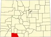 | |
| CDP | ||
| Unincorporated communities | ||
| Ghost towns | ||
| Indian reservation | ||
| Footnotes | ‡This populated place also has portions in an adjacent county or counties | |
