Berabuchina
Berabuchna
বেড়াবুচিনা | |
|---|---|
Interactive map of Berabuchna | |
| Coordinates: 24°12′27″N 89°54′06″E / 24.207501°N 89.901534°E | |
| Country |  Bangladesh |
| Division | Dhaka Division |
| District | Tangail District |
| Time zone | UTC+6 (BST) |
| Postal Code | 1207 |
Berabuchina (also spelt as Berabuchna) is a mahalla (neighborhood) in Ward No. 11 in the Bangladeshi city of Tangail.
History
Santosh, 2 km from Berabuchina, is the place where Biswanath Choudhury established the Santosh zamindari, that had control over the surrounding area, including Berabuchina, and his son Manmatha Nath Roy Chowdhury (1883–1939) made it famous with his philanthropic and other activities, The last zamindar, Golok Nath Roy Choudhury, migrated to India with his family after abolition of the zamindari system.[1][2]
Personality
Jnanjan Niyogi, a noted freedom fighter and a social reformer, belonged to a family which had hailed from Berabuchina.[3]
Geography

2.5miles

U:union parishads, M: mahalla or neighbourhood
Owing to space constraints in the small map, the actual locations in a larger map may vary slightly
Berabuchina is in Tangail municipal corporation and is situated on the banks of the Louhajang River in a floodplain near the Jamuna River, which contributes to its fertile land. It is 83 kilometers northwest of Dhaka, the capital of Bangladesh. The city experiences a tropical savanna climate, characterized by hot, humid summers and warm, dry winters.[4]
Demographics
Berabuchna had a total population of 3,194 in 734 households as per 2011 census.[5]
In the administrative unit of Berabuchna in ward no 11 of Tangail Poursabha, Berabuchna had a population of 3194 of which 3170 were Muslims and 24 were Hindus.[6]
Economy
Approximately 6 to 7 lakh looms, including both hand and power looms, are currently operating in Bangladesh. Most are concentrated in Pabna, Sirajganj, Tangail, Narsingdi, and the hill districts. The number of handlooms has been declining every year, while power looms are on the rise and about 1 lakh handlooms remain closed at present due to economic factors.[7]
Mir Shanowar Ali owns the Agro and Dairy Farm in Berabuchna, indicating the rise of expansion of alternative means of earning.[8]
Education
Berabuchna Government Primary School is a Bengali-medium school.[9]
Mawlana Bhashani Science and Technology University at Santosh nearby.[10]
Facilities
As per 2011 census, Berabuchna had 726 households. 89.8% of the households drew their water from tube wells and 10.2% households used tap water. 97.5% of the households had electricity. 77.4% of households owned their houses. [11]
A large water tank of Tangail Pourosava is located in Berabuchina.[12]
Pictures
 Berabuchina Post Office
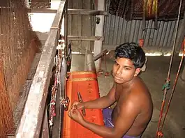 A weaver Berabuchina
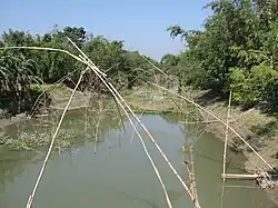 Louhajang River near Berabuchina
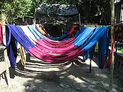 Coloured coton thread left to dry in Aloa village adjacent to Berabuchina
 A pond in Berabuchina
 Jahnavai High School in Santosh as seen from the road to Berabuchina
References
- ↑ "The Zamindars of Muslim Bengal". Shamsul Arefin Shakti. Retrieved 9 June 2026.
- ↑ Moymonsingher Itihas o Moymonsingher Bibaran in Bengali, history and description of Mymensingh District of Bangladesh by Kedarnath Mazumdar, pages 129-130. Published by Anandadhara, Dhaka in 2005.
- ↑ Our Light Our Lineage by Prosad Kamal Niyogi, published by Bee Books, ISBN 978-81-980783-0-8
- ↑ "Tangail". banglaNest. Retrieved 8 June 2026.
- ↑ "Table C-01 : Area, household, population and density by residence and community, page 128" (PDF). Population and Housing Census 2011. Archived from the original on 2 December 2016. Retrieved 8 June 2026.
{{cite web}}: CS1 maint: bot: original URL status unknown (link) - ↑ "Table C-13: Distribution of population by religion, residence and community, Page 904" (PDF). Population and Housing Census 2011. Archived from the original (PDF) on 2 December 2016. Retrieved 8 June 2026.
- ↑ "Weavers face sluggish sales ahead of Eid by Ahmed Humayun Kabir Topu". The Daily Star. 6 March 2026. Retrieved 8 June 2026.
- ↑ "Giant 'Rajababu' bull create attention in Tangail". Daily Industry. Retrieved 8 June 2026.
- ↑ "Berabuchna Government Primary School". archive south asia. Retrieved 7 June 2026.
- ↑ "Mawlana Bhashani Science and Technology University". MBSTU. Retrieved 7 June 2026.
- ↑ "Table C-15: Percentage distribution of general household by source of drinking water, electricity connection, tenancy status of house, residence and community" (PDF). Bangladesh Population and Housing Census, Tangail, page 1056. Archived from the original on 2 December 2016. Retrieved 9 June 2026.
{{cite web}}: CS1 maint: bot: original URL status unknown (link) - ↑ "Berabuchna Panir Tank, Tangail Pourashava Water Supply". Cybo. Retrieved 8 June 2026.
| Upazilas/thanas | | |
|---|---|---|
Tangail District Populated Places | |||||||||||||||||||||||||
|---|---|---|---|---|---|---|---|---|---|---|---|---|---|---|---|---|---|---|---|---|---|---|---|---|---|
| Union Councils |
| ||||||||||||||||||||||||
| Cities and towns |
| ||||||||||||||||||||||||
| Villages | |||||||||||||||||||||||||
| Neighbourhoods | |||||||||||||||||||||||||
| Related topics | |||||||||||||||||||||||||
