B2 road (Namibia)
 | ||||
|---|---|---|---|---|
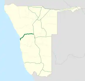 Map of the B2. | ||||
| Route information | ||||
| Maintained by Roads Authority Namibia | ||||
| Length | 320 km (200 mi) | |||
| Major junctions | ||||
| East end |   A1 / B1 near Okahandja | |||
| West end |  C14 in Walvis Bay | |||
| Location | ||||
| Country | Namibia | |||
| Towns | Okahandja, Karibib, Usakos, Arandis, Swakopmund, Walvis Bay | |||
| Highway system | ||||
| ||||

B2 is a major road in Namibia. The highway runs east–west between the major sea port of Walvis Bay and the nation's capital Windhoek.[1]
The B2's entire route forms the first section of both the Trans-Kalahari Corridor and the Walvis Bay-Ndola-Lubumbashi Development Road.

Route
B2 begins in Walvis Bay at a roundabout intersection with the C14 and heads north along the coast of the South Atlantic Ocean for about 35 kilometers to Swakopmund. The route then heads northeast & east through inland Namibia for 291 kilometers where it ends at an intersection with B1 near Okahandja, approximately 74 kilometres north of Windhoek. The route passes through the Namib-Naukluft National Park and the Namib Desert. Major towns along the route are Arandis, Usakos, and Karibib.
References
- ↑ "Along the B2 from Windhoek to the coast, Okahandja, Karibib and Usakos - The Bradt guide to Namibia". www.namibia-travel-guide.com. Retrieved 2026-05-17.
| Freeways | | |
|---|---|---|
| Trunk routes | ||
| Secondary routes | ||
| International routes | ||
