Đất Mũi
Đất Mũi | |
|---|---|
 Đất Mũi Market | |
Interactive map of Đất Mũi | |
| Country |  Vietnam |
| Province | Cà Mau |
| Establishment | June 16, 2025 |
| Area | |
• Total | 271.20 km2 (104.71 sq mi) |
| Population (2025) | |
• Total | 33.298 |
| • Density | 0.12278/km2 (0.31800/sq mi) |
| Time zone | UTC+07:00 |
Đất Mũi is a commune (xã) and village in Cà Mau province, in Vietnam.
The Standing Committee of the National Assembly issued Resolution No. 1655/NQ-UBTVQH15[1] on the rearrangement of commune-level administrative units of Cà Mau province in 2025 (the resolution takes effect from 16 June 2025). Accordingly, Đất Mũi commune was established in Cà Mau province on the basis of the entire natural area of 147.20 km² and a population of 18,032 people of Đất Mũi commune; the adjustment of 119.30 km² in natural area with a population of 15,266 people from Viên An commune; and the adjustment of 4.70 km² in natural area with no residents from the Hòn Khoai island cluster of Tân Ân commune, Ngọc Hiển district.
Geography
Đất Mũi is the southernmost commune on the mainland of Vietnam. It is home to the national coordinate marker and Mũi Cà Mau National Park. Its geographical location is as follows:
- To the east, it borders Phan Ngọc Hiển Commune.
- To the south, it borders the South China Sea.
- To the west, it borders the Gulf of Thailand.
- To the north, it borders Đất Mới Commune.
Đất Mũi Commune covers an area of 271.20 km²; as of 2024, it has a population of 33,298 people, resulting in a population density of approximately 123 people/km².
Administration divisions
Dat Mui Commune is divided into 22 hamlets: Ba Khue, Cai Hoang, Cai Moi, Cai Xep, Con Cat, Con Mui, Khai Long, Kinh Dao, Kinh Dao Dong, Kinh Nam, Mui, Nguyen Quyen, Ong Linh, Ong Trang, Rach Tau, Rach Tau Dong, Rach Tho, Sac Co, So Dua, Vinh Nuoc Soi, Xeo Mam, and Xom Bien.[2][3]
History
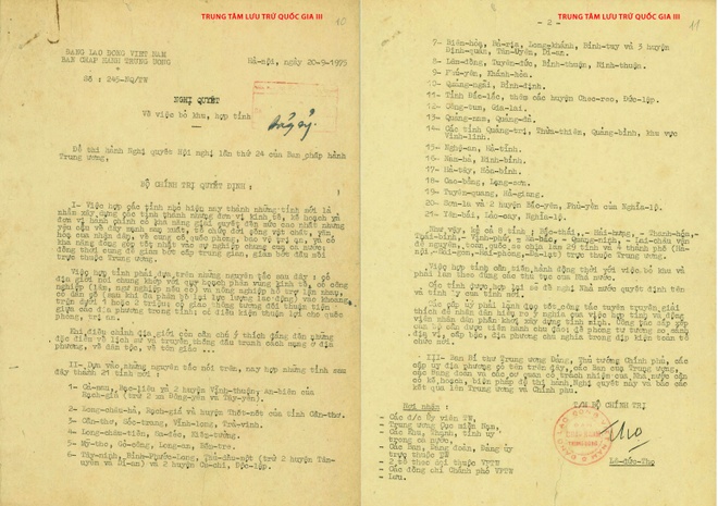
On September 20, 1975, the Politburo issued Resolution No. 245-NQ/TW[4] regarding the merger of Bạc Liêu province, Cà Mau province and 2 districts An Biên district and Vĩnh Thuận district (excluding Dong Yen and Tay Yen communes) of Rạch Giá province into a new province. The name of the new province and the location of the provincial capital will be proposed by the local authorities.
On December 20, 1975, the Politburo issued Resolution No. 19/NQ[5] Regarding the merger of Bạc Liêu and Cà Mau provinces into a new province, the name of the new province and the location of the provincial capital will be proposed by the local authorities.
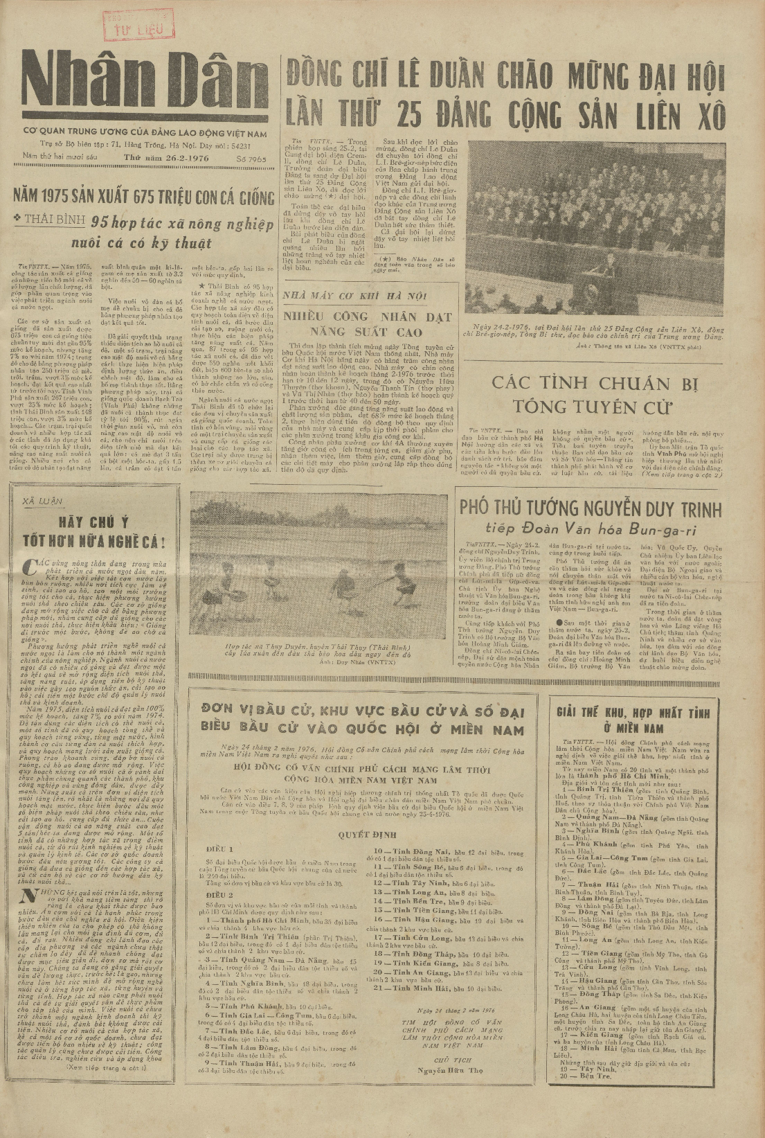
On February 24, 1976, the Provisional Revolutionary Government of the Republic of South Vietnam issued Decree No. 3/NQ/1976[6] regarding the merger of Bạc Liêu province and Cà Mau province into a new province, named Bạc Liêu – Cà Mau province.
On March 10, 1976, the Government issued a Resolution[7] regarding the establishment of Minh Hải province on the basis of renaming Bạc Liêu – Cà Mau province.
On July 25, 1979, the Government Council issued Decision No. 275-CP[8] on dividing Vien An commune in Ngọc Hiển district into 3 communes: Duyên An Đông (Viên An Đông), Duyên An Tây (Viên An Tây), and Đất Mũi.
On December 17, 1984, the Government Council issued Decision No. 168-HĐBT[9] Regarding:
- Changing the name of Ngọc Hiển district to Ngọc Hiển district.
- Transferring Dat Mui commune from Ngọc Hiển district to the newly renamed Ngọc Hiển district.
On November 6, 1996, the National Assembly issued Resolution[10] on the division of Minh Hải into Bạc Liêu and Cà Mau provinces.
On June 12, 2025, the National Assembly issued Resolution No. 202/2025/QH15[11] on the arrangement of provincial-level administrative units (Resolution effective from June 12, 2025). Accordingly, the province of Bac Lieu is merged into the province of Ca Mau.
June 16, 2025:
- The National Assembly issued Resolution No. 203/2025/QH15[12] regarding the amendment and supplementation of several articles of the Constitution of the Socialist Republic of Vietnam. Accordingly, the operation of district-level administrative units nationwide will cease from July 1, 2025.
- The Standing Committee of the National Assembly issued Resolution No. 1655/NQ-UBTVQH15[13] Regarding the reorganization of commune-level administrative units in Ca Mau province in 2025 (resolution effective from June 16, 2025). Accordingly, Dat Mui commune is established in Ca Mau province based on the entire 147.20 km² of natural area and a population of 18,032 people of Dat Mui commune; adjusting 119.30 km² of natural area and a population of 15,266 people of Vien An commune; and adjusting 4.70 km² of uninhabited natural area of Hon Khoai island cluster belonging to Tan An commune, Ngoc Hien district.
Dat Mui commune has a natural area of 271.20 km² and a population of 33,298 people.[14]
Tourism
Đất Mũi Commune features:
- Đất Mũi Tourist Area
- Khai Long Tourist Area
- GPS Coordinate Marker 0001
- Mũi Cà Mau National Park
- Hon Khoai
Transportation
The road transportation network—specifically the Ho Chi Minh Highway—has been constructed and fully completed up to the commune's administrative center. From the administrative center to the various hamlets, roads with concrete surfaces are in place, though they are not yet suitable for large tourist coaches.
Waterway transportation is highly developed, thanks to an extensive and dense network of canals and creeks.
References
- ↑ "Cổng thông tin điện tử Quốc hội". quochoi.vn. Retrieved 2026-05-09.
{{cite web}}: CS1 maint: url-status (link) - ↑ Ministry of Ethnic Affairs and Religion (2026-01-29). "List of Hamlets in ethnic minority and mountainous regions, and hamlets facing extreme difficulties for the 2026–2030 period within Ca Mau Province" (PDF). Electronic Information Portal of the Ministry of Ethnic Affairs and Religion. Archived (PDF) from the original on 2026-04-25. Retrieved 2026-04-25.
- ↑ Dat Mui Commune Electronic Information Portal - Ca Mau Province (2026-03-03). "Dat Mui Commune Election Committee Announces Official List of Candidates for the Dat Mui Commune People's Council, 2026–2031 Term". Archived from the original on 2026-05-16. Retrieved 2026-03-29.
- ↑ "Resolution No. 245-NQ/TW on abolishing zones and merging provinces". 1975-09-20. Archived from the original on 2025-04-07. Retrieved 2025-04-07.
- ↑ "Resolution No. 19/NQ on adjusting the merger of some provinces in the South". National Archives Center I. 1975-12-20. Archived from the original on 2025-05-07. Retrieved 2025-05-07.
- ↑ "Decree No. 3/NQ/1976 on the dissolution of zones and consolidation of provinces in Southern Vietnam". National Archives Center I. 1976-02-24. Archived from the original on 2025-05-07. Retrieved 2025-05-07.
- ↑ Resolution on renaming certain provinces.
- ↑ "Decision No. 275-CP of 1979 on adjusting the boundaries of some communes and towns in Minh Hai province". Law Library. 1979-07-25.
{{cite web}}: CS1 maint: url-status (link) - ↑ "Decision No. 168-HĐBT of 1984 on renaming some districts in Minh Hai province". 1984-12-17. Archived from the original on 2021-12-16. Retrieved 2021-12-16.
{{cite web}}: CS1 maint: bot: original URL status unknown (link) - ↑ "Resolution on the division and adjustment of administrative boundaries of some provinces". Law Library. 1996-11-06.
{{cite web}}: CS1 maint: url-status (link) - ↑ "Resolution No. 202/2025/QH15 on the arrangement of provincial-level administrative units". Vietnam National Assembly Electronic Information Portal. 2025-06-12. Archived from the original on 2025-06-12. Retrieved 2025-06-12.
- ↑ "Resolution No. 203/2025/QH15 on amending and supplementing a number of articles of the Constitution of the Socialist Republic of Vietnam". Vietnam National Assembly Electronic Information Portal. 2025-06-16. Archived from the original on 2025-06-16. Retrieved 2025-06-16.
- ↑ "Resolution No. 1655/NQ-UBTVQH15 on the arrangement of commune-level administrative units of Ca Mau province in 2025". Vietnam National Assembly Electronic Information Portal. 2025-06-16. Archived from the original on 2025-06-16. Retrieved 2025-06-16.
- ↑ Ca Mau Provincial People's Council (2025-04-28). "Resolution No. 15/NQ-HĐND on approving the policy of rearranging commune-level administrative units of Ca Mau province in 2025" (PDF). Ca Mau Provincial People's Council. Archived from the original (PDF) on 2025-06-11. Retrieved 2025-06-11.