Zvërnec Island
Native name: Ishulli i Zvërnecit | |
|---|---|
 Zvërnec Island | |
Interactive map of Zvërnec Island | |
| Geography | |
| Location | Narta Lagoon, Adriatic Sea |
| Coordinates | 40°31′02″N 19°24′06″E / 40.51722°N 19.40167°E |
| Area | 0.09 km2 (0.035 sq mi) |
| Length | 0.43 km (0.267 mi) |
| Width | 0.30 km (0.186 mi) |
| Highest elevation | 25 m (82 ft) |
| Administration | |
Albania | |
Zvërnec Island is an island within the Narta Lagoon in southern Albania.
The island is nearly all covered with tall pine trees and is just east of a much smaller island. It is 430m in length and has a maximum width of 300m. Zvërnec Island is connected to the mainland by a 270m long wooden bridge.
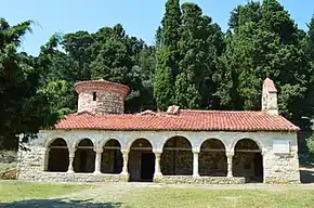
The island is a tourist attraction because it contains the well preserved 13th-14th century Byzantine Zvërnec Monastery.[1] Located nearby is the village of Zvërnec, from which the island derives its name.[2] The island has an area about 9 hectares.
Historically, the island’s St. Mary's Monastery, Zvërnec was under the ecclesiastical jurisdiction of nearby Nartë, as the present-day village of Zvërnec did not yet exist when the monastery was founded; today both Nartë and Zvërnec belong to the Qendër Vlorë administrative unit of Vlorë Municipality. The monastery complex has been protected as a Cultural Monument since 1963.[3]
Zvërnec Monastery
 Zvernec Monastery


See also
References
- ↑ Elsie, Robert (2001). Balkanistica, Vol. 13: The Christian Saints of Albania. American Association for South Slavic Studies. p. 39 – via books.google.com.
- ↑ Laurìa, Antonio; Flora, Valbona; Guza, Kamela (2020). Five Albanian Villages. Guidelines for a Sustainable Tourism Development through the Enhancement of the Cultural Heritage (PDF). Firenze University Press. p. 227. ISBN 978-88-5518-174-7. Archived (PDF) from the original on 7 December 2025.
- ↑ "Njësitë Administrative". Porta Vendore. Archived from the original on 24 October 2025. Retrieved 4 July 2026.
40°31′N 19°24′E / 40.517°N 19.400°E