Whatitirinui Island
| Whatitirinui Island | |
|---|---|
 1910 Gilmour Brothers photo of Whatitirinui Island | |
Interactive map of Whatitirinui Island | |
| Nearest city | Raglan |
| Coordinates | 37°45′50″S 174°55′19″E / 37.764°S 174.922°E |
| Max. elevation | 30 ft (9.1 m) |
Whatitirinui Island is a small island in the Whāingaroa Harbour, north of Paritata Peninsula and less than a kilometre west of Te Teko Island. It is about 5 km (3.1 mi) north of Raglan.[1]
Ownership
The island is referred to in the Iwi Environmental Management Plan of Ngāti Tamainupō[2] and Tainui Awhiro and Ngāti Māhanga also have interests in Whāingaroa Harbour, which are being considered by the Waitangi Tribunal.[3]
Name
Whatitirinui Island is the New Zealand Geographic Board official name, the origin of which is unknown. The Board say it has also been called Watatounui Island[4] and in 1880 it was described as Tawata, a very small island, some 30 ft (9.1 m) high.[5] It was sometimes also called Sugar Loaf.[6][7] Whatitiri is one of the Māori names for Pomaderris phylicifolia[8] and nui translates as large.[9] Pomaderris is a threatened – nationally critical, flowering shrub,[10] growing up to 1.5 m (4 ft 11 in) high, which prefers poor, dry, soils and is shaded out in forests.[11] In 1959 it was recorded on the nearby Motukokako Reserve.[12]
Geology
Like most of the surrounding headlands, Whatitirinui Island is mainly formed of Mangiti sandstone, a hard calcareous fine to medium sandstone and lesser siltstone deposited in beds of roughly decimetre thickness, laid on a deepening mid to outer shelf in the Whaingaroan age, about 40 million years ago.[13]
On top of the sandstone is the much more recent Whakarau Formation, inferred to be mid to late Haweran, which is about 30,000 years old. It has fossils of macrofauna which still live in the harbour, including Austrovenus stutchburyi, Cyclomactra tristis, Dosinia lambata and Zeacumantus. The formation was formed in a flooded harbour, due to a rise in sea level following the late Pleistocene glaciation.[13]
Environment
A site on the mudflats, near Whatitirinui Island, has been sampled quarterly since 2001[14] for macrofauna and sediment chemistry. Results indicate macrofauna have been moderately affected by mud, with scores generally between 3 and 4, on a scale of 1 (best) to 6 (worst). Heavy metal levels have been very low.[15] Of the six sites monitored in Whāingaroa Harbour, it is generally in the top two for healthy macrofauna.[16]
 Whatitirinui viewed from Karioi (left in the northern arm of the harbour)
 Whatitirinui aerial view
 Whatitirinui from east
 Whatitirinui from south
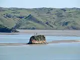 Whatitirinui from Paritata
 Whatitirinui north end
See also
Notes
References
- ↑ "Whatitirinui Island, Waikato". NZ Topo Map. Retrieved 3 May 2026.
- ↑ "Ngāti Tamainupō Mātauranga and Taonga Management Plan" (PDF). December 2021.
- ↑ "Te Mana Whatu Ahuru" (PDF). Waitangi Tribunal. 2018. p. 96.
- ↑ "Whatitirinui Island". gazetteer.linz.govt.nz. 31 March 1949. Retrieved 3 May 2026.
- ↑ "Raglan And Its Neighbourhood. Waikato Times". 28 February 1880.
- ↑ "Raglan as a health resort. Waikato Times". 11 November 1903.
- ↑ "A Sunday school picnic. Waikato Times". 21 March 1931.
- ↑ "whatitiri". Te Aka Māori Dictionary. Retrieved 3 May 2026.
- ↑ "Pomaderris phylicifolia. Tauhinu". Manaaki Whenua - Landcare Research. 30 October 2023.
- ↑ "Pomaderris phylicifolia" (PDF). New Zealand Plant Conservation Network. 30 July 2025.
- ↑ "Pomaderris phylicifolia subsp. phylicifolia". New Zealand Plant Conservation Network. Retrieved 3 May 2026.
- ↑ M. G. Gudex (16 September 1959). "The Native Flora of Motukokako Reserve".
- 1 2 B C Waterhouse; P J White (1994). Geology of the Raglan-Kawhia Area.
{{cite book}}: CS1 maint: multiple names: authors list (link) - ↑ "Waikato Regional Estuary Monitoring - sediments". www.waikatocoastaldatabase.org.nz. Retrieved 4 May 2026.
- ↑ "Whatitirinui Island (WI)". Land, Air, Water Aotearoa (LAWA). Retrieved 4 May 2026.
- ↑ "Coastal ecosystem health". www.waikatoregion.govt.nz. 2024. Retrieved 4 May 2026.