Utingeradeel
Utingeradeel
Utingeradiel | |
|---|---|
Former municipality | |
 | |
 Flag  Coat of arms | |
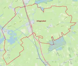 Location in Friesland | |
| Coordinates: 53°02′54″N 5°50′16″E / 53.048437°N 5.83786°E | |
| Country | Netherlands |
| Province | Friesland |
| Established | 1 October 1816 [1] |
| Dissolved | 1 January 1984 |
| Area | |
• Total | 152.50 km2 (58.88 sq mi) |
| Population (1980)[2] | |
• Total | 5,369 |
| • Density | 35.21/km2 (91.2/sq mi) |
| Time zone | UTC+1 (CET) |
| • Summer (DST) | UTC+2 (CEST) |
Utingeradeel (West Frisian: Utingeradiel) is a former municipality in the province of Friesland in the Netherlands.
The municipality was split into two parts on 1 January 1984, Boornsterhem and Skarsterlân.
Population centres
The municipality of Utingeradeel contained six villages as of its dissolution in 1983. Its capital was Oldeboorn until 1932, followed by Akkrum.
| Dutch Name | West Frisian |
|---|---|
| Akkrum | Akkrum |
| Oldeboorn | Aldeboarn |
| Terhorne | Terherne |
| Terkaple | Terkaple |
| Nes | Nes |
| Akmarijp | Eagmaryp |
There were also a number of hamlets in the municipality; Birstum, Henshuizen, Oude Schouw, Poppenhuizen, Sorremorre and Warniahuizen.
References
- ↑ "Utingeradeel". gemeentegeschiedenis.nl (in Dutch). Gemeentegeschiedenis. Retrieved 18 July 2026.
- ↑ "Bevolkingsontwikkeling; levend geborenen, overledenen en migratie per region" [Population development; live births, deaths and migration by region]. CBS Statline (in Dutch). CBS. 10 July 2026. Retrieved 18 July 2026.
External links
 Media related to Utingeradeel at Wikimedia Commons