Gate District, St. Louis
The Gate District | |
|---|---|
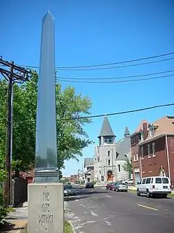 The entrance to the Gate District on Compton Avenue. | |
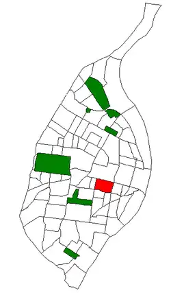 Location (red) of the Gate District within St. Louis | |
| Country | United States |
| State | Missouri |
| City | St. Louis |
| Wards | 7 |
| Government | |
| • Aldermen | Alisha Sonnier |
| Area | |
• Total | 0.65 sq mi (1.7 km2) |
| Population (2020)[1] | |
• Total | 3,419 |
| • Density | 5,300/sq mi (2,000/km2) |
| ZIP code(s) | Part of 63104 |
| Area code(s) | 314 |
| Website | stlouis-mo.gov |
The Gate District is a neighborhood of St. Louis, Missouri. The Gate District is defined as the area between Chouteau Avenue and Interstate 44 on the north and south and between South Jefferson Avenue and South Grand Boulevard on the east and west. This area is just south of the central corridor and west of Lafayette Square. The term Gate was added to define this neighborhood due to the number of ironclad gates lining the streets. Today, the neighborhood is the subject of increased gentrification.
Demographics
In 2020 The Gate District's racial makeup was 72.5% Black, 19.2% White, 0.1% Native American, 1.9% Asian, 5.1% Two or More Races, and 1.1% Some Other Race. 3.0% of the population was of Hispanic or Latino origin.[2]
| Year | Pop. | ±% |
|---|---|---|
| 1990 | 3,403 | — |
| 2000 | 3,491 | +2.6% |
| 2010 | 3,456 | −1.0% |
| 2020 | 3,419 | −1.1% |
| [3] | ||
| Racial composition | 2000[4] | 2010[5] | 2020 |
|---|---|---|---|
| White | 10.1% | 14.4% | 19.2% |
| Black or African American | 86.7% | 82.0% | 72.5% |
| Hispanic or Latino (of any race) | 1.1% | 1.1% | 3.0% |
| Asian | 0.5% | 1.3% | 1.9% |
Household & Housing Households: ~1,616, average 2 people per household
Family households: ~677 (41.9%)
Non-family households: ~939 (58.1%) Point2
Housing units: ~1,761, with occupancy rates above 90% City of St. Louis, MO
Income & Education Median household income: ~$68,764–$89,198 depending on source
Education: Higher than national averages — 22% with master’s degrees, 24% with bachelor’s degrees, 32% with some college, and 14% with high school diplomas
Neighborhood Parks
The Gate District is subdivided into four neighborhoods:[6]
- St. Vincent
Public Library
Barr Branch:https://www.slpl.org/ https://www.google.com/maps/place/St.+Louis+Public+Library+-+Barr+Library/@38.6146846,-90.2216846,3a,75y,126.53h,90t/data=!3m7!1e1!3m5!1swNdLK-
Fire Station Number 7
2600 LaSalle Street, 63104, in The Gate District https://www.stlouis-mo.gov/government/departments/public-safety/fire/firehouse-locations.cfm
University
St Louis university Medical School: https://www.slu.edu/medicine/index.php
Center for advanced Dental education: https://www.slu.edu/cade/index.php
Florist ROW
- Walter Knoll
- Baisch & Skinner
- Verdtech
- Belli Fiori
- Floral Supply Syndicate
- Harld's Wholesale florist
References
- ↑ 2020 Census Neighborhood Results
- ↑ "City of St. Louis" (PDF). Retrieved September 15, 2021.
- ↑ "Census". Archived from the original on May 16, 2012. Retrieved August 15, 2012.
- ↑ "The City of St. Louis Missouri". City of St. Louis.
- ↑ "The City of St. Louis Missouri". City of St. Louis. Archived from the original on May 16, 2012. Retrieved August 15, 2012.
- ↑ The Gate District: Map


38°37′11″N 90°13′46″W / 38.6196°N 90.2294°W