Katowice–Legnica railway
| Sudeten Main Line | |||
|---|---|---|---|
 Sudeten main line in Prudnik. View of the railway towards Kędzierzyn-Koźle, on the right is a disused signal box | |||
| Overview | |||
| Native name | Polish: Magistrala Podsudecka | ||
| Status | Operational | ||
| Owner | PKP PLK | ||
| Line number | 137 | ||
| Locale | Poland | ||
| Termini | |||
| Connecting lines | See connecting lines | ||
| Stations | 47 | ||
| Service | |||
| Type | Heavy rail | ||
| Operator(s) | PKP Intercity Polregio Lower Silesian Railways Silesian Railways PKP Cargo Private railway companies | ||
| History | |||
| Work began | 1844 | ||
| Opened | 21 July 1844 | ||
| Last extension | 15 August 1876 | ||
| Completed | 1876 | ||
| Technical | |||
| Line length | 284.1 km (176.5 mi) | ||
| Number of tracks | Single and Dual track | ||
| Track gauge | 1,435 mm (4 ft 8+1⁄2 in) standard gauge | ||
| Electrification | Partly, 3 kV DC | ||
| Operating speed | 120 km/h (75 mph) | ||
| |||

The Katowice–Legnica railway, also known as the Sudeten Main Line (Polish: Magistrala Podsudecka) is a 284.1 km (176.5 mi) long partly electrified mainline in Poland, connecting both cities of Katowice and Legnica.[1] The railway is located within the borders of the Silesian, Opole, and Lower Silesian voivodeships, within the operational areas of the PKP PLK railway line units in Sosnowiec, Tarnowskie Góry, Opole, Wałbrzych, and Wrocław.[2] The railway is called Sudeten Main Line due to the location along the Sudetes mountain range stretching from Prudnik to Legnica.[3]
The railway was built and opened in sections between 1844 and 1876. It provided a connection between the industrialized settlements of the Sudeten Foreland and the mines of Upper Silesia. Prior to the nationalization of the railways, the railway was owned entirely by Upper Silesian Railway. From its inception, it was classified as a first-rate railway of major national importance.[3]
The railway used to be numbered 74 according to D29 from 1949, the number changed to 103 in 1971, and changed to the current number 137 in 1985 where its current number is still being used today.[4]
Route
Geography
The line starts at Katowice railway station at Środmieście in Katowice on the end point of the Warsaw–Katowice railway and the Oświęcim–Katowice railway, it heads west passing Katowice Załęże, Chorzów Batory, Świętochołcice, Ruda Śląska, Zabrze and Gliwice. From there, it continues through Gliwice Łabędy to Kędzierzyn-Koźle, where the Kędzierzyn-Koźle–Opole Groszowice railway begins.[5]
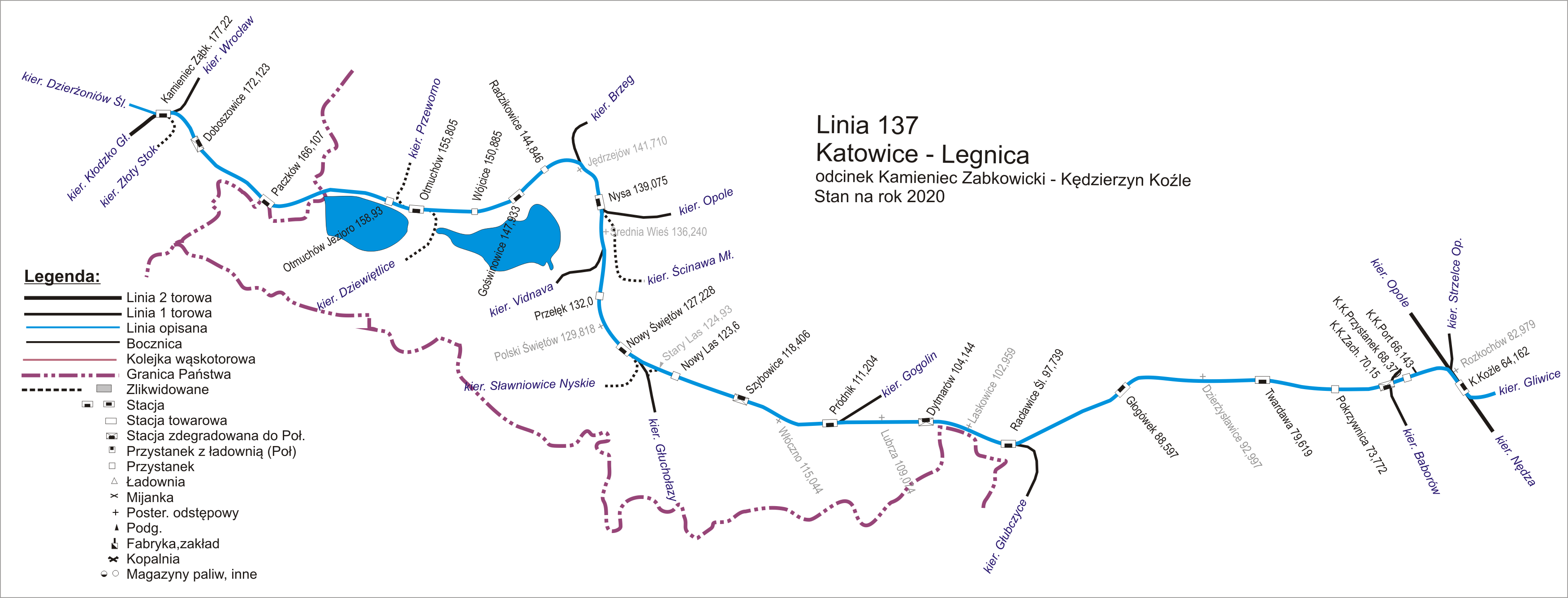
The line still heads east passing Kędzierzyn Koźle Przystanek, Kędzierzyn Koźle Zachodnie, Głogówek, Racławice Śląskie and to Prudnik, where the Krapkowice–Prudnik railway ends. Next it runs through Nowy Świętów, Nysa, Otmuchów, Paczków and to Kamieniec Ząbkowicki where it crosses the Wrocław–Międzylesie railway.[5]
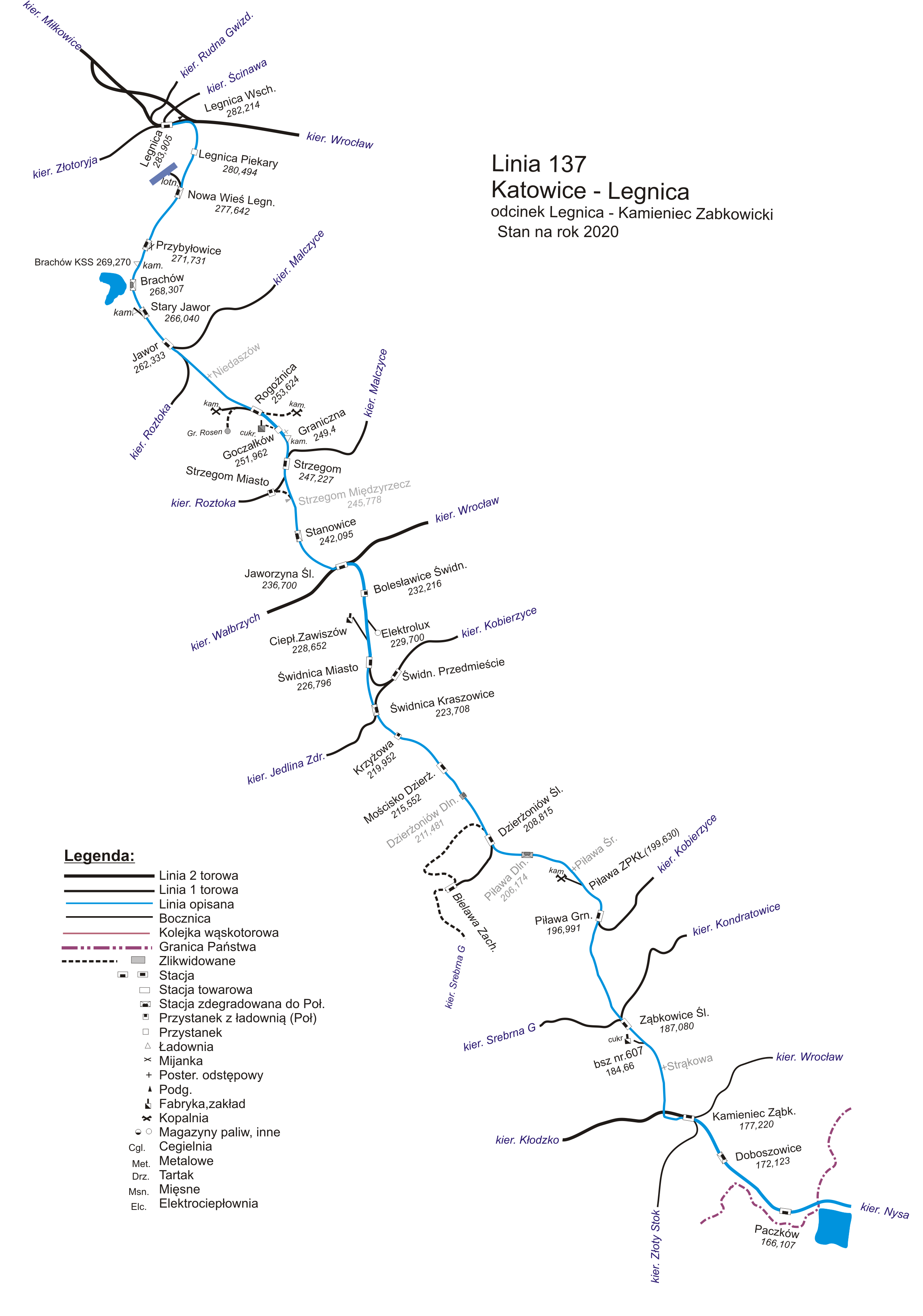
From there, the line heads north through Ząbkowice Śląskie, Piława Górna, Dzierżoniów Śląski, Świdnica Miasto, Jaworzyna Śląska, where it crosses with line Wrocław Świebodzki–Zgorzelec railway, Strzegom, and Jawor. The line ends at Legnica railway station, where it connects with Wrocław Muchobór–Gubinek railway.[5]
Connecting lines
Operational
- Warszawa Zachodnia–Katowice railway
- Oświęcim–Katowice railway
- Katowice –Zwardoń railway
- Chorzów Batory–Tczew railway
- Ruda Chebzie–Zabrze Biskupice railway
- Zabrze Biskupice–Gliwice railway
- Katowice Ligota–Gliwice railway
- Gliwice Łabędy–Pyskowice railway
- Toszek–Rudziniec Gliwicki railway
- Kędzierzyn-Koźle–Chałupki railway
- Kędzierzyn Koźle–Opole railway
- Krapkowice–Prudnik railway
- Nowy Świętów–Głuchołazy railway
- Opole–Nysa railway
- Nysa–Brzeg railway
- Wrocław–Międzylesie railway
- Bielawa–Dzierżoniów railway
- Wrocław–Jedlina Zdrój railway
- Wrocłąw Świebodzki–Zgorzelec railway
- Wielkie Piekary–Miłkowice railway
- Wrocław–Gubinek railway
Partly operational
- Malczyce–Grabina railway
- Jawor–Roztoka railway
Defunct
- Polska Cerekiew–Baborów railway
- Głubczyce–Racławice Śląskie railway
- Nowy Świętów–Sławniowice Nyskie railway
- Nysa–Kałków Łąka railway
- Nysa–Ścinawa Mała railway
- Otmuchów–Dziewiętlice railway
- Otmuchów–Przeworno railway
- Kamieniec Ząbkowicki–Złoty Stok railway
- Malczyce–Jawor railway
Under revitalization
- Kobierzyce–Piława Górna railway
Sections
The line is divided into 16 sections[6]
- A: Katowice – Chorzów Batory (0,070 to 6,166)
- B: Chorzów Batory – Gliwice (6,166 to 27,100)
- C: Gliwice – Szobiszowice (27,100 to 28,530)
- D: Szobiszowice – Gliwice Łabędy (28,530 to 32,985)
- E: Gliwice Łabędy – Rudziniec Gliwicki (32,985 to 49,056)
- F: Rudziniec Gliwicki – Nowa Wieś (49,056 to 61,623)
- G: Nowa Wieś – Kędzierzyn-Koźle (61,623 to 64,162)
- H: Kędzierzyn-Koźle – Kędzierzyn-Koźle Zachodnie (64,162 to 70,150)
- J: Kędzierzyn-Koźle Zachodnie – Prudnik (70,150 to 111,696)
- K: Prudnik – Nysa (111,696 to 139,075)
- L: Nysa – Kamieniec Ząbkowicki (139,075 to 177,219)
- M: Kamieniec Ząbkowicki – Świdnica Miasto (177,219 to 226,796)
- N: Świdnica Miasto – Jaworzyna Śląska (226,796 to 236,765)
- O: Jaworzyna Śląska – Strzegom (236,765 to 247,227)
- P: Strzegom – Jawor (247,227 to 262,333)
- R: Jawor – Legnica (262,333 to 284,190)
History
Jaworzyna Śląska – Świdnica section
Plans and construction

In 1841, plans were underway in Silesia to build additional connections, including from Legnica through Jawor, Strzegom, Świdnica, and Dzierżoniów to Ząbkowice Śląskie, from where two branches were to extend: through Kłodzko and Międzylesie to the Czech lands (Austria) and through Nysa to Koźle. In order to avoid the delay of the line construction due to the resistance of the Świdnica military authorities, it was decided to route it to Świebodzice, hoping that over time the fortress command would change its position. Difficult "military" negotiations continued and intensified significantly in 1843, when there was already an argument in hand in the form of an almost completed line to Świebodzice. Ultimately, in November 1843, after the first section of the line had already been commissioned, the authorities of the Wrocław Regency were presented with a compromise project, which outlined, among other things, the route of the line, the location of the terminal station in Świdnica (also a dead-end), and the planned opening date of the line.[7]
The branch from Jaworzyna Śląska was laid perpendicular to the main line in a south-eastern direction. After leaving the station, the tracks led in a gentle curve to the right. About 1,300 metres (4,300 ft) from the junction, they crossed the old coal road Ciernie — Kąty almost at a right angle, after which they ran straight for 7.4 kilometres (4.6 mi) to the terminal station in Świdnica. By constructing several embankments and cuttings, it was possible to lay the line almost "as on a table." From 233 metres (764 ft) above sea level in Jaworzyna Śląska to 231 metres (758 ft) above sea level in Świdnica. The deepest and longest cuttings were created north of Bolesławice and west of Tomkowa, while the highest embankments, along with water culverts, were at the points where the line crossed the Bagieniecka River and its tributary, as well as the Jabłoniec. Between the two towns, there was no intermediate station, although the line passed just west of Bolesławice and just east of Tomkowa. The length of this single-track line was nearly 9 kilometres (5.6 mi), and the terminal station in Świdnica was located right at the fortress boundary.[7]
Price of the construction
The Wrocław–Świdnica–Świebodzice Railway Company was, during its construction and the first years of operation, conventionally divided into two parts. The main line from Wrocław Świebodzki through Jaworzyna Śląska to Świebodzice, and the branch line from Jaworzyna Śląska to Świdnica. The former had a length of 15,278 rods, which is 57.445 kilometres (35.695 mi), while the latter was 2,380 rods, which is 8.949 kilometres (5.561 mi). One rod (German: Ruthe) measured 3.76 metres (12.3 ft). Overall expenditures on the construction of the main line amounted to nearly 1,724,000 thalers, and for the construction of the branch line, over 290,000 thalers. In total, 2,014,131 thalers were spent.[7]
On the branch line from Jaworzyna Śląska to Świdnica, the largest amount was spent on constructing the track surface, which is the trackbed, sleepers, rails, other, totaling over 66,000 talers (426,000 — the corresponding expenditure amounts for the main line are given in parentheses). Only slightly less, 57,000 talers (202,000), was spent on preparing the areas for construction, which is line surveying. The next item was the construction of the railway station in Świdnica — 43,778 talers. The total cost of building the other five stations on the main line amounted to nearly 364,000 talers. Additionally, although relatively small, there were costs for building stops in Smolec (392 talers) and Mietków (491 talers).[7]
The purchase of land for the construction of the branch line consumed over 33,000 talers (214,000 for the main line), the construction of railway crossings over 12,000 talers (50,300), and bridges and culverts nearly 11,400 (60,900 talers). The remaining common costs were divided proportionally between both lines. For example, the purchase of cars — 20,500 talers (133,000), locomotives nearly 17,000 talers (107,500), the construction of a coking plant for the railway's needs in the village of Ciernie 4,000 talers (32,300), or the purchase of uniforms for staff 685 talers (4,200).[7]
Certain additional costs on the branch line arose due to the Świdnica fortress. For example, more than 55 thalers were paid for the transfer of gunpowder, stored in the fortress magazine located near the newly constructed station. Furthermore, it was necessary to maintain a financial reserve of as much as 30,000 thalers to cover the potential costs of constructing a bridge 75 metres (246 ft) long, which, according to the authorities’ demand, was to be built in the area of the Świdnica fortress as a necessary defensive element. Presumably, this was intended in which the final section of the track before the station could be blown up, thereby preventing the enemy from advancing with a train directly to the fortress's borders. Moreover, similar demands were made by the military authorities 10 years later, when permission was finally granted to extend this line to Dzierżoniów, and that through the fortress itself.[7]
References
- ↑ "Wykaz linii ld-12 (D-29)" (PDF). plk-sa.pl (in Polish). 2009-02-09. p. 22. Retrieved 2026-06-25.
- ↑ "Linie kolejowe wg obszarów działania zakładów linii kolejowych" (PDF). plk.sa.pl (in Polish). Retrieved 2026-06-27.
- 1 2 "KolejPodsudecka". kolejpodsudecka.pl. Retrieved 2026-06-25.
- ↑ "Index". www.jelenia.rail.pl. Retrieved 2026-07-10.
- 1 2 3 Waguła, Hubert; Fedorowicz, Sławomir; Ślęzok, Robert. "Linia kolejowa 137 (PL) • Katowice - Legnica / Atlas Kolejowy Europy Środkowej". www.atlaskolejowy.net. Retrieved 2026-06-25.
- ↑ "Wykaz linii ld-12 (D-29)" (PDF). plk.sa.pl (in Polish). 2016-12-30. p. 93. Retrieved 2026-06-27.
- 1 2 3 4 5 6 Scheer, Andrzej (1994). "Sto pięćdziesiąt lat kolei w Świdnicy na tle kolei śląskich" (in Polish). pp. 28–98. Retrieved 2026-07-11.
External links
 Media related to Railway line 137 (Poland) at Wikimedia Commons
- Kędzierzyn-Koźle–Kamieniec Ząbkowicki section diagram - Jelenia Rail (in Polish)
- Kamieniec Ząbkowicki–Legnica section diagram - Jelenia Rail (in Polish)
| Railway stations |
|  |
|---|---|---|
| Railway lines |
| |
- Rail transport in Legnica County
- Standard-gauge railways in Poland
- Railway lines in Lower Silesian Voivodeship
- Railway lines in Opole Voivodeship
- Railway lines opened in 1844
- 1844 establishments in Poland