Seymour Canal
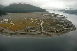
Seymour Canal is an inlet penetrating deep into the southeastern part of Admiralty Island, Southeast Alaska, United States.[1]
The canal gave its name to the Seymour Canal Formation, a major geological formation composed of graywacke, argillite, and conglomerate rocks dating from the Late Jurassic and Early Cretaceous periods.[2]
History
The inlet was first charted in 1794 by Joseph Whidbey, master of HMS Discovery during George Vancouver's 1791–95 expedition. Vancouver later named it "Seymour's Channel",[3] which evolved into the modern name Seymour Canal. Two large islands are located within it: Swan Island to the north, and Tiedeman Island just to its south.
Wildlife
Seymour Canal is one of the world's highest concentrations of nesting bald eagles. There is also large populations of brown bears.[4]
References
- ↑ U.S. Geological Survey Geographic Names Information System: Seymour Canal
- ↑ "Geolex — SeymourCanal publications". ngmdb.usgs.gov. Retrieved 2026-06-25.
- ↑ Vancouver, George, and John Vancouver (1801). A voyage of discovery to the North Pacific ocean, and round the world. London: J. Stockdale.
{{cite book}}: CS1 maint: multiple names: authors list (link) - ↑ "Oliver Inlet State Marine Park". dnr.alaska.gov. Retrieved 2026-06-25.