San Augustine, Texas
San Augustine, Texas | |
|---|---|
 Imogene Cafe in downtown San Augustine | |
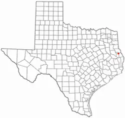 Location of San Augustine, Texas | |
 | |
| Coordinates: 31°31′48″N 94°06′41″W / 31.53000°N 94.11139°W | |
| Country | United States |
| State | Texas |
| County | San Augustine |
| Area | |
• Total | 4.80 sq mi (12.44 km2) |
| • Land | 4.72 sq mi (12.22 km2) |
| • Water | 0.089 sq mi (0.23 km2) |
| Elevation | 345 ft (105 m) |
| Population (2020) | |
• Total | 1,920 |
| • Density | 400.2/sq mi (154.53/km2) |
| Time zone | UTC-6 (Central (CST)) |
| • Summer (DST) | UTC-5 (CDT) |
| ZIP code | 75972 |
| Area code | 936 |
| FIPS code | 48-65024[3] |
| GNIS feature ID | 2411775[2] |
| Website | City website |
San Augustine is the county seat of San Augustine County[4] in East Texas, United States. Its population was 1,920 at the 2020 census.
History
The first European settlement in the area began in 1717 with the establishment of Mission Nuestra Señora de los Dolores de los Ais by Spanish missionaries. The mission was abandoned and re-established in 1721. It lasted until 1773 and is now preserved as Mission Dolores State Historic Site.
Before the establishment of the town, a small number of residents lived in the Ayish Bayou area. They had briefly fled during the Fredonian Rebellion in 1822 to escape Mexican forces. The town was established in 1832 under alcalde William McFarland by the site of the mission, then owned by Thomas S. McFarland. The town was named after the Presidio de San Agustín de Ahumada, which had been named in honor of the (1755–1761) Viceroy of New Spain, Don Agustín de Ahumada y Villalón.[5] McFarland laid out a grid of 356 plots,[6] making it the first town laid out in the Anglo-American style rather than the Spanish one.[7]
In 1832, residents sent men to fight in the Battle of Nacogdoches. They elected Sam Houston as delegate for the Convention of 1833. They again fled from Mexican forces during the Texas Revolution, during the Runaway Scrape. After the end of the war, San Augustine was made seat of San Augustine County. Methodist, Presbyterian, and Methodist Episcopal churches were established. Its Presbyterian church was the first Protestant church in Texas, established in 1839. Three universities were established, the University of San Augustine, the Wesleyan College, and the University of Eastern Texas, all of which shut down within a few years of their founding.[6]
Three companies of soldiers were sent from the city during the Civil War.[6]
Cotton and lumber were major industries in the town's early history, with railroad expansions allowing for industrial sawmill operations. The lumber industry largely left the town in the Great Depression,[6] but returned later. The town's location in the Piney Woods make it an excellent lumber area.[7]
Newspapers published in the town began with the San Augustine Red-Lander, and continued with the San Augustine Rambler, the Cotton Belt News, the Saxon, the Herald, and the still-publishing San Augustine Tribune.[6]
Geography
San Augustine is located at 31°31′52″N 94°06′39″W / 31.531086°N 94.110971°W (31.531086, –94.110971).[8]
According to the United States Census Bureau, the city has a total area of 4.8 square miles (12 km2), of which 0.1 square miles (0.26 km2) (2.08%) is covered by water.
Climate
The climate in this area is characterized by hot, humid summers and generally mild to cool winters. According to the Köppen climate classification, San Augustine has a humid subtropical climate, Cfa on climate maps.[9]
| Climate data for San Augustine, Texas (1991–2020 normals, extremes 1909–1917, 2000–present) | |||||||||||||
|---|---|---|---|---|---|---|---|---|---|---|---|---|---|
| Month | Jan | Feb | Mar | Apr | May | Jun | Jul | Aug | Sep | Oct | Nov | Dec | Year |
| Record high °F (°C) | 83 (28) |
85 (29) |
95 (35) |
93 (34) |
98 (37) |
104 (40) |
105 (41) |
112 (44) |
108 (42) |
97 (36) |
89 (32) |
90 (32) |
112 (44) |
| Mean daily maximum °F (°C) | 59.5 (15.3) |
63.2 (17.3) |
70.2 (21.2) |
76.9 (24.9) |
84.0 (28.9) |
90.3 (32.4) |
93.5 (34.2) |
94.4 (34.7) |
88.5 (31.4) |
79.5 (26.4) |
69.7 (20.9) |
61.0 (16.1) |
77.6 (25.3) |
| Daily mean °F (°C) | 47.4 (8.6) |
51.1 (10.6) |
57.7 (14.3) |
64.7 (18.2) |
72.5 (22.5) |
79.0 (26.1) |
82.0 (27.8) |
82.1 (27.8) |
76.4 (24.7) |
66.5 (19.2) |
56.6 (13.7) |
48.8 (9.3) |
65.4 (18.6) |
| Mean daily minimum °F (°C) | 35.4 (1.9) |
39.0 (3.9) |
45.3 (7.4) |
52.5 (11.4) |
60.9 (16.1) |
67.7 (19.8) |
70.4 (21.3) |
69.9 (21.1) |
64.3 (17.9) |
53.4 (11.9) |
43.5 (6.4) |
36.5 (2.5) |
53.2 (11.8) |
| Record low °F (°C) | 7 (−14) |
1 (−17) |
17 (−8) |
22 (−6) |
35 (2) |
50 (10) |
57 (14) |
56 (13) |
38 (3) |
22 (−6) |
14 (−10) |
8 (−13) |
1 (−17) |
| Average precipitation inches (mm) | 4.95 (126) |
5.11 (130) |
5.22 (133) |
4.65 (118) |
4.30 (109) |
4.80 (122) |
3.22 (82) |
4.28 (109) |
4.18 (106) |
4.75 (121) |
4.70 (119) |
5.40 (137) |
55.56 (1,411) |
| Average snowfall inches (cm) | 0.1 (0.25) |
0.1 (0.25) |
0.0 (0.0) |
0.0 (0.0) |
0.0 (0.0) |
0.0 (0.0) |
0.0 (0.0) |
0.0 (0.0) |
0.0 (0.0) |
0.0 (0.0) |
0.0 (0.0) |
0.0 (0.0) |
0.2 (0.51) |
| Average precipitation days (≥ 0.01 in) | 9.2 | 8.4 | 8.0 | 7.1 | 7.3 | 8.2 | 7.0 | 6.5 | 6.3 | 6.0 | 7.6 | 8.9 | 90.5 |
| Average snowy days (≥ 0.1 in) | 0.1 | 0.1 | 0.0 | 0.0 | 0.0 | 0.0 | 0.0 | 0.0 | 0.0 | 0.0 | 0.0 | 0.0 | 0.2 |
| Source: NOAA[10][11] | |||||||||||||
Demographics
| Census | Pop. | Note | %± |
|---|---|---|---|
| 1870 | 250 | — | |
| 1880 | 503 | 101.2% | |
| 1890 | 744 | 47.9% | |
| 1900 | 261 | −64.9% | |
| 1910 | 1,204 | 361.3% | |
| 1920 | 1,268 | 5.3% | |
| 1930 | 1,247 | −1.7% | |
| 1940 | 1,516 | 21.6% | |
| 1950 | 2,510 | 65.6% | |
| 1960 | 2,584 | 2.9% | |
| 1970 | 2,539 | −1.7% | |
| 1980 | 2,930 | 15.4% | |
| 1990 | 2,337 | −20.2% | |
| 2000 | 2,475 | 5.9% | |
| 2010 | 2,108 | −14.8% | |
| 2020 | 1,920 | −8.9% | |
| U.S. Decennial Census[12] | |||
Racial and ethnic composition
| Race / Ethnicity (NH = Non-Hispanic) | Pop 2000[13] | Pop 2010[14] | Pop 2020[15] | % 2000 | % 2010 | % 2020 |
|---|---|---|---|---|---|---|
| White alone (NH) | 894 | 767 | 629 | 36.12% | 36.39% | 32.76% |
| Black or African American alone (NH) | 1,430 | 1,092 | 968 | 57.78% | 51.80% | 50.42% |
| Native American or Alaska Native alone (NH) | 2 | 1 | 0 | 0.08% | 0.05% | 0.00% |
| Asian alone (NH) | 17 | 9 | 13 | 0.69% | 0.43% | 0.68% |
| Native Hawaiian or Pacific Islander alone (NH) | 0 | 0 | 0 | 0.00% | 0.00% | 0.00% |
| Other race alone (NH) | 0 | 5 | 0 | 0.00% | 0.24% | 0.00% |
| Mixed race or Multiracial (NH) | 5 | 13 | 38 | 0.20% | 0.62% | 1.98% |
| Hispanic or Latino (any race) | 127 | 221 | 272 | 5.13% | 10.48% | 14.17% |
| Total | 2,475 | 2,108 | 1,920 | 100.00% | 100.00% | 100.00% |
2020 census
As of the 2020 census, 1,920 people, 741 households, and 536 families resided in the city, the median age was 42.2 years, 23.6% of residents were under the age of 18, and 23.0% were 65 years of age or older.[16][17]
For every 100 females there were 89.0 males, and for every 100 females age 18 and over there were 87.7 males age 18 and over.[16]
0.0% of residents lived in urban areas, while 100.0% lived in rural areas.[18]
There were 741 households in San Augustine, of which 33.5% had children under the age of 18 living in them. Of all households, 34.5% were married-couple households, 18.9% were households with a male householder and no spouse or partner present, and 40.5% were households with a female householder and no spouse or partner present. About 33.2% of all households were made up of individuals and 15.3% had someone living alone who was 65 years of age or older.[16]
There were 935 housing units, of which 20.7% were vacant. The homeowner vacancy rate was 1.9% and the rental vacancy rate was 5.4%.[16]
| Race | Number | Percent |
|---|---|---|
| White | 661 | 34.4% |
| Black or African American | 970 | 50.5% |
| American Indian and Alaska Native | 3 | 0.2% |
| Asian | 15 | 0.8% |
| Native Hawaiian and Other Pacific Islander | 0 | 0.0% |
| Some other race | 136 | 7.1% |
| Two or more races | 135 | 7.0% |
2000 census
As of the census[3] of 2000, 2,475 people, 859 households, and 573 families were living in the city. The population density was 525.2 inhabitants per square mile (202.8/km2). The 1,076 housing units had an average density of 228.3 per square mile (88.1/km2). The racial makeup of the city was 37.82% White, 57.94% African American, 0.08% Native American, 0.69% Asian, 3.07% from other races, and 0.40% from two or more races. Hispanics or Latino of any race were 5.13% of the population.
Of the 859 households, 29.8% had children under 18 living with them, 37.3% were married couples living together, 26.0% had a female householder with no husband present, and 33.2% were not families. About 30.5% of all households were made up of individuals, and 17.0% had someone living alone who was 65 or older. The average household size was 2.57 and the average family size was 3.23. The age distribution was 26.9% under 18, 8.1% from 18 to 24, 22.6% from 25 to 44, 19.7% from 45 to 64, and 22.7% who were 65 or older. The median age was 38 years. For every 100 females, there were 80.4 males. For every 100 females 18 and over, there were 67.6 males.
The median income for a household in the city was $25,489, and for a family was $33,203. Males had a median income of $23,750 versus $17,628 for females. The per capita income for the city was $14,918. About 19.1% of families and 24.7% of the population were below the poverty line, including 35.0% of those under age 18 and 30.7% of those age 65 or over.
Education
The city of San Augustine is served by the San Augustine Independent School District. The city was once home to the University of San Augustine (Texas)
Notable people

- Kenneth Lewis Anderson, The last vice president of the Republic of Texas
- Edward A. Clark, U.S. ambassador to Australia
- Dominique Edison, Seattle Seahawks wide receiver
- Joseph Barton Elam, U.S. representative from Louisiana's 4th congressional district from 1877 to 1881
- John A. Greer, lieutenant governor of Texas
- Frances Cox Henderson, wife of Governor Henderson, helped establish Episcopal Church in San Augustine
- J. Pinckney Henderson, the first governor of the State of Texas
- Sam Houston, the first president of the Republic of Texas
- Kenneth M. Hoyt, U.S. district judge
- Memucan Hunt, Jr., secretary of the Navy of the Republic of Texas and Texas' minister to the United States
- Ben Ramsey, Texas lieutenant governor
- John A. Ramsey, prominent libertarian entrepreneur and philanthropist
- Oran M. Roberts, governor
- Franklin Barlow Sexton, Texas senator, grand commander of the Knights Templar of Texas
Photo gallery
 Retail stores in Historic Commercial District
 Angus Theater
 San Augustine Drug Store and Heart of Texas Grill
 Texas State Bank
 Presbyterian Church
 San Augustine County Courthouse
 Retail stores in Historic Commercial District
 Historic building in downtown San Augustine
 Hail Blount House, April 2012
 Lewis Hotel
 Christ Church Episcopal Church
 The Columns Bed and Breakfast

See also
References
- ↑ "2019 U.S. Gazetteer Files". United States Census Bureau. Retrieved August 7, 2020.
- 1 2 U.S. Geological Survey Geographic Names Information System: San Augustine, Texas
- 1 2 "U.S. Census website". United States Census Bureau. Retrieved January 31, 2008.
- ↑ "Find a County". National Association of Counties. Retrieved June 7, 2011.
- ↑ "City of San Augustine, Texas". City of San Augustine, Texas. Archived from the original on April 17, 2012. Retrieved August 4, 2012.
- 1 2 3 4 5 Association, Texas State Historical. "History and Development of San Augustine, Texas". Texas State Historical Association. Retrieved June 25, 2026.
- 1 2 West, Richard. "The Petrified Forest". Texas Monthly. Retrieved June 25, 2026.
- ↑ "US Gazetteer files: 2010, 2000, and 1990". United States Census Bureau. February 12, 2011. Retrieved April 23, 2011.
- ↑ Climate Summary for San Augustine, Texas
- ↑ "NOWData - NOAA Online Weather Data". National Oceanic and Atmospheric Administration. Retrieved November 2, 2023.
- ↑ "Summary of Monthly Normals 1991-2020". National Oceanic and Atmospheric Administration. Retrieved November 2, 2023.
- ↑ "Census of Population and Housing". Census.gov. Retrieved June 4, 2015.
- ↑ "P004: Hispanic or Latino, and Not Hispanic or Latino by Race – 2000: DEC Summary File 1 – San Augustine city, Texas". United States Census Bureau.
- ↑ "P2: Hispanic or Latino, and Not Hispanic or Latino by Race – 2010: DEC Redistricting Data (PL 94-171) – San Augustine city, Texas". United States Census Bureau.
- ↑ "P2: Hispanic or Latino, and Not Hispanic or Latino by Race – 2020: DEC Redistricting Data (PL 94-171) – San Augustine city, Texas". United States Census Bureau.
- 1 2 3 4 "2020 Decennial Census Demographic Profile (DP1)". United States Census Bureau. 2021. Retrieved February 13, 2026.
- 1 2 "2020 Decennial Census Redistricting Data (Public Law 94-171)". United States Census Bureau. 2021. Retrieved February 13, 2026.
- ↑ "2020 Decennial Census Demographic and Housing Characteristics (DHC)". United States Census Bureau. 2023. Retrieved February 13, 2026.
External links

- Official website
- Texas State Historical Association
- Chamber of Commerce Archived January 16, 2012, at the Wayback Machine
Municipalities and communities of San Augustine County, Texas, United States | ||
|---|---|---|
| City |  | |
| Town | ||
| Unincorporated communities | ||
| Ghost town | ||