Lake Salagou

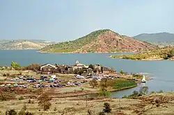

Lake Salagou (French: lac du Salagou) is a reservoir formed by the Salagou Dam. It is located in the central part of the Hérault department in southern France, on the Salagou river, a tributary of the Lergue River, which in turn flows into the Hérault River.[1]
Geography
The lake has an average depth of 15 metres[1] and a maximum measured depth of 50 metres.[2] Its normal operating level is 139 metres above sea level. The original plan envisaged raising the level to 150 metres, which would have submerged the village of Celles. Although the village was evacuated, the higher level was never implemented; in 1996, the maximum level was definitively fixed at 139 metres.[3][4] The lake covers approximately 750 hectares and has a storage capacity of 103 million cubic metres.[1]
The surrounding mountains and plateaus rise to 300 metres in the east and 407 metres at Carels in the west.[5] To the south, Mont Liausson rises to 535 metres and forms a natural barrier between Lake Salagou and the dolomitic cirque of Mourèze.[6]
Communes
The lake extends across six communes: Celles, Clermont-l'Hérault, Le Puech, Liausson, Octon, Salasc.[1]
References
- 1 2 3 4 "Lac du Salagou". Hérault (in French). Conseil départemental de l'Hérault. Retrieved 3 August 2026.
- ↑ "Salagou". L'eau dans le bassin Rhône-Méditerranée (in French). Agence de l'eau Rhône Méditerranée Corse. Retrieved 3 August 2026.
- ↑ Boyer, Jean-Marc (May 2017). "Opération Grand Site Salagou - Cirque de Mourèze" (in French). Ministry of Ecological Transition (France). p. 10. Retrieved 3 August 2026.
- ↑ Krémer, Pascale (27 April 2024). "Sur les rives du lac du Salagou, un village fantôme sauvé des eaux renait en cité idéale". Le Monde (in French). Retrieved 3 August 2026.
- ↑ Rouet, Michel (6 January 2012). "Le lac du Salagou (Hérault)". Association Vendéenne de Géologie (in French). Retrieved 3 August 2026.
- ↑ "La Montagne de Liausson". Grand Site Salagou–Cirque de Mourèze (in French). Syndicat Mixte Salagou–Cirque de Mourèze. 11 April 2019. Retrieved 3 August 2026.

43°39′33″N 3°22′05″E / 43.65912°N 3.36813°E