Princess Royal Harbour
| Princess Royal Harbour | |
|---|---|
| Mamang Koort (Menang Noongar) | |
 The harbour in 2022 | |
Interactive map of Princess Royal Harbour | |
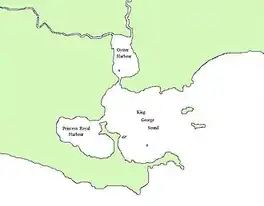 Location relative to King George Sound | |
| Location | Albany, Western Australia |
| Coordinates | 35°S 118°E / 35°S 118°E |
| Type | Harbour |
| Etymology | Charlotte, Princess Royal |
| Part of | King George Sound |
Ocean/sea sources | Indian Ocean |
| Max. length | 8 km (5.0 mi) (NW to SE) |
| Max. width | 4 km (2.5 mi) |
Surface area | 28.8 km2 (11.1 sq mi) |
| Settlements | |
Princess Royal Harbour (Menang Noongar: Mamang Koort[1]) is a part of King George Sound on the south coast of Western Australia, and harbour to Albany. On its northern shore is the Port of Albany. The name Princess Royal also appears in Albany in Princess Royal Fortress and Princess Royal Drive.
History

- Princess Royal Harbour, 1854,
- watercolour by Duncan Cooper
The first European to explore the waters was George Vancouver on HMS Discovery in September 1791; he named the harbour after Princess Charlotte Augusta Matilda, the first daughter and fourth child of King George III.
The harbour was surveyed by Matthew Flinders in 1802, Jules Dumont d'Urville in 1826, John Lort Stokes in 1848, and Henry Mangles Denham in 1858.[2]
The harbour was less than 2 metres (6 ft 7 in) deep until it was dredged in 1901,[3] and its entrance was dredged in 1952.[4]
Princess Royal Harbour was the departure location for a large convoy of Australian troops in November 1914.[5][6]
The entrance to the harbour was named Ataturk Channel in 1985 for Mustafa Kemal Atatürk;[7] it is also known as Atatürk Entrance.[8][9][10][11]
Geography
Princess Royal Harbour is an almost landlocked extension of King George Sound on the south coast of Western Australia. Roughly elliptical in shape, it is 8 km (5.0 mi) long northwest to southeast, 4 km (2.5 mi) wide, and has a surface area of 28.8 km2 (11.1 sq mi).[12]
The harbour is a deep basin with an average water depth of 3.1 m (10 ft) at mean sea level. It is bordered by a shallow intertidal to subtidal zone, most extensive off its western and southern shores.[12]
No significant rivers flow into the harbour. Its entrance from King George Sound – Ataturk Channel – is short and narrow. Through that entrance, which has a minimum sectional area of 3,470 m2 (37,400 sq ft), there is a shipping channel, maintained to a depth of 12.5 m (41 ft). Within the harbour, a turning basin adjacent to the port wharfs on the northeast shore has been dredged to 12 m (39 ft) deep.[12]
Ecology
The harbour is the location of a seagrass meadow of Posidonia.[13]
Water quality has been tested and monitored over time.[14][15][16]
References
- ↑ "Princess Royal Harbour Coastal Hazard Risk Management and Adaptation Plan (CHRMAP)" (PDF). City of Albany. 12 May 2026. Retrieved 1 August 2026.
- ↑ Great Britain. Hydrographic Department; Denham, Henry Mangles, Sir, 1800–1887; Dumont d'Urville, Jules-Sébastien-César, 1790–1842; Flinders, Matthew, 1774–1814; Stokes, J. Lort (John Lort), 1811–1885; Potter, J. D. (John D.); J. & C. Walker (1859), Western Australia, King George Sound and Princess Royal Harbour (Additions to 1859 ed.), Published at the Admiralty, 24th Sepr. 1858 under the superintendence of Captn. Washington, R.N. F.R.S. hydrographer : Sold by J.D. Potter, Agent for the Admiralty charts, 31 Poultry and 11 King St., Tower Hill, retrieved 1 May 2016
{{citation}}: CS1 maint: multiple names: authors list (link) CS1 maint: numeric names: authors list (link) - ↑ "Country". The West Australian. Perth: National Library of Australia. 19 January 1904. p. 3. Retrieved 30 June 2012.
- ↑ "Dredges Work Long Hours At Albany". The West Australian. Perth: National Library of Australia. 26 February 1952. p. 9. Retrieved 30 June 2012.
- ↑ "Drama of... the convoys". The Argus. Melbourne: National Library of Australia. 24 April 1937. p. 30 Supplement: Week–End Magazine. Retrieved 30 June 2012.
- ↑ "Services Tattoo". The Sydney Morning Herald. National Library of Australia. 6 April 1938. p. 23. Retrieved 30 June 2012.
- ↑ "Atatürk Channel". Anzac Albany. Retrieved 13 June 2016.
- ↑ "PM salutes Turks for generosity to Anzacs". The Canberra Times. Vol. 64, no. 20, 100. Australian Capital Territory, Australia. 24 April 1990. p. 3. Retrieved 13 June 2016 – via National Library of Australia.
- ↑ "Quaranup and Ataturk Entrance from King Point". 1994. Retrieved 13 June 2016 – via National Library of Australia.
- ↑ "Ataturk Entrance". visitalbany.com. Retrieved 13 June 2016.
- ↑ Monument Australia Plaque details Mustafa Kemal Ataturk, 25 April 1985, retrieved 29 October 2022
- 1 2 3 Mills, D A; D'Adamo, N (March 1993). Water circulation and flushing characteristics of Princess Royal Harbour (PDF) (Report). Technical Series No. 51. Perth: Environmental Protection Authority (Western Australia). p. 3. Retrieved 1 August 2026.
- ↑ Gordon, David Mackintosh; Western Australia. Department of Environmental Protection (1994), Changes to the structure and productivity of a Posidonia sinuosa seagrass meadow in Princess Royal Harbour, Western Australia, during and after imposed shading, Dept. of Environmental Protection, ISBN 978-0-7309-4685-4
- ↑ Platell, N. E. (Noel Edward); Western Australia. Government Chemical Laboratories (1978), Water quality monitoring survey of Princess Royal Harbour, Albany, Govt. Chemical Laboratories, ISBN 978-0-7244-7912-2
- ↑ Atkins, R. P., 1951-; Western Australia. Department of Conservation and Environment; Western Australia; Atkins, R (1980), A Technical report on the water quality of Princess Royal Harbour, Albany, Dept. of Conservation and Environment, ISBN 978-0-7244-8453-9
{{citation}}: CS1 maint: multiple names: authors list (link) CS1 maint: numeric names: authors list (link) - ↑ Princess Royal Harbour : summary of technical report on the water quality of Princess Royal Harbour, Albany, Dept. of Conservation & Environment, 1980, retrieved 1 May 2016
External links
 Media related to Princess Royal Harbour at Wikimedia Commons