Pitt Island (Canada)
 Northern End of Pitt Island as seen from Grenville Channel | |
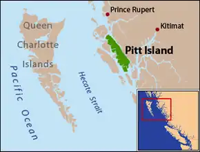 Pitt Island is located between Banks Island and the mainland. | |
| Geography | |
|---|---|
| Coordinates | 53°30′00″N 129°47′00″W / 53.50000°N 129.78333°W |
| Area | 1,398.55 km2 (539.98 sq mi) (2026)[a] |
| Area rank | 40th in Canada & 270th worldwide |
| Length | 90 km (56 mi) |
| Width | 8 km (5 mi) |
| Highest elevation | 962 m (3156 ft) |
| Administration | |
Canada | |
| Province | British Columbia |
Pitt Island is an island located on the north coast of British Columbia, Canada.[1] The island is of cultural and ecological importance.[2]
Pitt island is located between Banks Island, across Grenville Channel (part of the Inside Passage) from the mainland, and is separated from Banks Island by Principe Channel.[3] The island is mountainous and heavily dissected by valleys, fjords, and inlets and has an area of 1,398.55 km2 (539.98 sq mi),[a] is 90 km (56 mi) long, and ranges from 8 to 23 km (5.0 to 14.3 mi) wide. Its highest point is at 962 m (3,156 ft).
Pitt Island is the only island in British Columbia known to host a resident population of moose.[6]
History
The Gitxaala occupied the island in the past, with a fishing and hunting village for each family group, [7] and have identified this island as part the laxyuup (traditional territories and waters)[8] of the Gitxaala. [9]
In 1792, Jacinto Caamafio commanding the frigate Aránzazu visited a village on the island.[10]
Geology
Pitt Island lies within the Coast Range Arc, part of the broader Coast Mountains geological province formed by subduction and terrane accretion along the edge of North American Plate. The island is part of an ancient collage that makes up the British Columbia Coast, where multiple island arcs and seafloor were accreted onto the Continental margin over hundreds of millions of years. The Coast Range Intrusive Complex, which includes Pitt Island, formed primarily in the mid to late Mesozoic as subduction processes drove extensive magmatism and crustal growth[11].
The dominant bedrock consists of intrusive rocks, mainly diorites and quartz diorites of acidic composition, that make up much of the island’s interior. These rocks represent magma that crystallized deep underground during the Cretaceous and were later exposed at the surface by tectonic uplift and erosion[11]. Like much of the coast, the island's superficial deposits, soils, colluvium, and glacial drift, were influenced by Pleistocene glaciation, which carved steep relief across the landscape[12].
Features
Protected Areas
- Union Passage Marine Provincial Park[29]
- Maxtaktsm'Aa/Union Passage Conservancy[30]
- Monckton Nii Luutiksm Conservancy[31]
- Pa-aat Conservancy[32]
Notes
- 1 2 Area from the United States Geological Survey, Esri, and the United Nations Environment Programme - World Conservation Monitoring Centre unless indicated otherwise[4][5]
References
- ↑ "Pitt Island". Natural Resources Canada. February 16, 2021.
- ↑ "Gitxaała Community‑led Planning and Management of the Pitt Island Mink Trap Watersheds". Watershed Security Fund. Watershed Security Fund. Retrieved 1 January 2026.
- ↑ "Pitt Island". BC Geographical Names. Government of British Columbia – B.C. Geographical Names Office (BCGNO).
- ↑ "Global Islands (USGS, ESRI, UNEP-WCMC)". 16 March 2026. Retrieved 19 July 2026.
- ↑ "Global Islands (USGS, ESRI, UNEP-WCMC) - USGSEsriWCMC GlobalIslandsv3 BigIslands". 16 March 2026. Retrieved 22 July 2026.
- ↑ Price Michael H, Darimont Chris T, Winchester Neville N, Paquet Paul C (2005). "Facts from faeces: prey remains in Wolf, Canis lupus, faeces revise occurrence records for mammals of British Columbia's coastal archipelago". Canadian Field-Naturalist. 119 (2): 192–196. doi:10.22621/cfn.v119i2.105. Retrieved 2020-06-22.
- ↑ Marsden, Susan (December 2011). The Gitkxaala, Their History, and Their Territories (Porcher Island, Banks Island, Pitt Island and Adjacent Islands) (PDF) (Report). Canadian Environmental Assessment Agency. Retrieved 2 January 2026.
- ↑ Menzies, Charles R. (2016). ""Laxyuup: The Land and Ocean Territories of Gitxaała"". People of the Saltwater: An Ethnography of Git Lax M’oon. University of Nebraska Press. ISBN 9780803291706. Retrieved 2026-01-02.
- ↑ "Our Story". Gitxaała Enterprises Corporation. Gitxaała Nation. Retrieved 1 January 2026.
- ↑ Golder Associates Ltd (13 April 2000). Report on an Archaeological Overview of the North Coast Timber Supply Area (PDF) (Report). British Columbia Ministry of Forests, North Coast District.
- 1 2 Warne, Jeff; Lloyd, John (May 1983). A Geophysical Report on a VLF-EM Survey on the Pit Claim for Ryan Exploration Ltd (Report). Vancouver, British Columbia: BC Ministry of Energy, Mines and Low Carbon Innovation, Assessment Report Indexing System (ARIS). Retrieved 27 December 2025.
- ↑ Clague, John J.; Ward, Bob (2011). "Pleistocene Glaciation of British Columbia" (PDF). Quaternary Science Reviews. 15: 563–577. doi:10.1016/B978-0-444-53447-7.00044-1.
In western British Columbia, ice streamed down fjords and valleys in the coastal mountains, producing erosional and depositional features characteristic of alpine and ice-sheet glaciation
- ↑ "Anchor Mountain". BC Geographical Names. Government of British Columbia – B.C. Geographical Names Office (BCGNO).
- ↑ "Captain Cove". BC Geographical Names. Government of British Columbia – B.C. Geographical Names Office (BCGNO).
- ↑ "Holmes Lake". BC Geographical Names. Government of British Columbia – B.C. Geographical Names Office (BCGNO).
- ↑ "Hevenor Inlet". BC Geographical Names. Government of British Columbia – B.C. Geographical Names Office (BCGNO).
- ↑ "Newcombe Harbour". BC Geographical Names. Government of British Columbia – B.C. Geographical Names Office (BCGNO).
- ↑ "Pa-aat River". BC Geographical Names. Government of British Columbia – B.C. Geographical Names Office (BCGNO).
- ↑ "Patterson Inley". BC Geographical Names. Government of British Columbia – B.C. Geographical Names Office (BCGNO).
- ↑ "Port Stevens". BC Geographical Names. Government of British Columbia – B.C. Geographical Names Office (BCGNO).
- ↑ "Monckton Inlet". BC Geographical Names. Government of British Columbia – B.C. Geographical Names Office (BCGNO).
- ↑ "Mount Hulke". BC Geographical Names. Government of British Columbia – B.C. Geographical Names Office (BCGNO).
- ↑ "Mount Patterson". BC Geographical Names. Government of British Columbia – B.C. Geographical Names Office (BCGNO).
- ↑ "Mount Frank". BC Geographical Names. Government of British Columbia – B.C. Geographical Names Office (BCGNO).
- ↑ "Mount Saunders". BC Geographical Names. Government of British Columbia – B.C. Geographical Names Office (BCGNO).
- ↑ "Mount Shields". BC Geographical Names. Government of British Columbia – B.C. Geographical Names Office (BCGNO).
- ↑ "Wyndham Lake". BC Geographical Names. Government of British Columbia – B.C. Geographical Names Office (BCGNO).
- ↑ "Red Bluff Lake". BC Geographical Names. Government of British Columbia – B.C. Geographical Names Office (BCGNO).
- ↑ "Union Passage Marine Park". BC Geographical Names. Government of British Columbia – B.C. Geographical Names Office (BCGNO).
- ↑ "Maxtaktsm'Aa/Union Passage Conservancy". BC Geographical Names. Government of British Columbia – B.C. Geographical Names Office (BCGNO).
- ↑ "Monckton Nii Luutiksm Conservancy". BC Geographical Names. Government of British Columbia – B.C. Geographical Names Office (BCGNO).
- ↑ "Pa-aat Conservancy". BC Geographical Names. Government of British Columbia – B.C. Geographical Names Office (BCGNO).
External links
